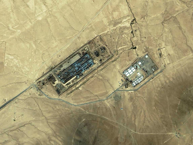
 In what now seems another life, I wrote about US torture during the early years of the “war on terror”, in ‘The Black Flag’ (which was specifically about Guantanamo, and which opened with three ‘suicides’ that we now have good reason to believe were anything but: see here and here) and ‘Vanishing Points’ (which extended the argument to Abu Ghraib and the archipelago of black sites like the ‘Salt Pit’ [shown below] within the global war prison). Both are available in their original forms under the DOWNLOADS tab, and form part of the material I’ve been working with for a new essay to be included in The everywhere war.
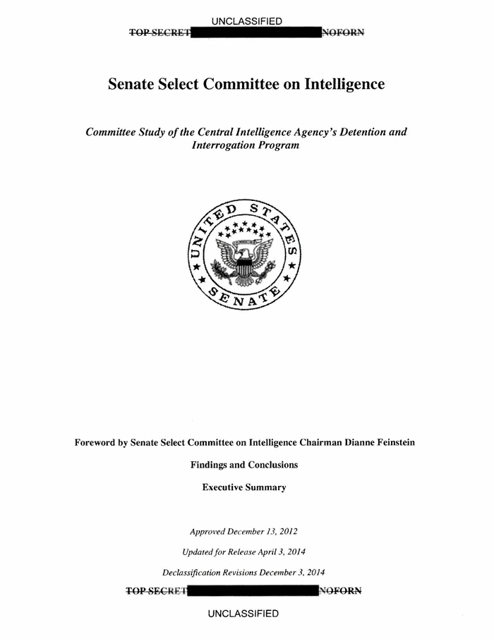 Now I’m digesting the Executive Summary that has been released by the Senate Select Committee on Intelligence on the CIA’s Detention and Interrogation Program, but you can download the original (redacted) summary here, ‘Other Views’ here, and the Minority View from the Republicans – and please God it remains a minority view – here.
The New York Times‘ coverage is here, the Washington Post‘s here, and the Guardian‘s here.
In the meantime, some of the best work on the dispersed geography of this vast apparatus was carried out by Trevor Paglen (see my updated discussion here).
Readers of his Blank spaces on the map will know of Trevor’s own attempt to see the ‘Salt Pit’ for himself, on the ground rather than from the air, and the images that result from this dimension of his work make clear – in plain sight, so to speak – their constitutive difficulties: see, for example, Jonah Weiner‘s essay on his work, ‘Prying eyes’, that appeared in the New Yorker here.
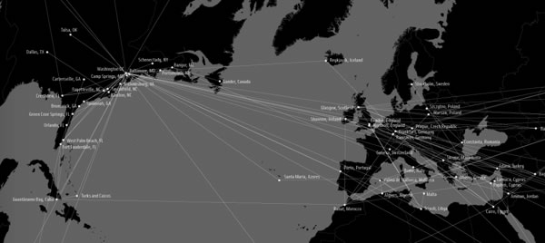
But here is part of what Trevor had to say about the mappings like the one above involved in his Torture Taxi and Terminal Air projects in An Atlas of Radical Cartography:
I’ve actually tried to stay away from cartography and “mapping” as much as possible in my work. The “God’s eye” view implicit in much cartography is usually not helpful in terms of describing everyday life, nor in describing the qualities of the relationships that cartography depicts. Because of what cartography cannot represent… it becomes pretty clear why it (and the forms of power that the cartographic viewpoint suggests) have traditionally been such powerful instruments of both colonialism and the contemporary geopolitical ordering of the world (which of course very much comes out of colonialism)…
I tend to be far more attracted to “on the ground” viewpoints and to embrace their fragmentedness and incompleteness. This project, as well as the “Terminal Air” project with the Institute for Applied Autonomy, are of course notable exceptions. With both of these projects that use the cartographic viewpoint, I was interested in taking what might seem like a familiar image and trying to and make it strange – trying to capture the feeling I had when I first started following CIA flights: it was the constant domestic flights to places like Tulsa, Las Vegas, Fresno, Fort Lauderdale and such that made a big impression on me. In working with John Emerson and the IAA, I insisted that we try to show a continuum between the domestic landscape and the landscape “somewhere else.” Neither of these projects are in my view not particularly useful as didactic tools but are instead useful in helping to see the point that we talked about above: that the “darkest” spaces of the war on terror blur into the everyday landscapes here “at home” and are in many way mutually constitutive. In this sense, they’re … images rather than analytic tools.
As I’ve noted before, this is part of the ‘capture’ side of the US kill-capture apparatus that uses drones (and often Special Forces) for the ‘kill’. I say ‘US’, but it’s clear – not least from the map above – that a network of other states that radiates far beyond the other ‘Five Eyes‘ which have been so deeply involved in providing geospatial intelligence for drone strikes (and more) has been complicit in the production and concealment of this global archipelago of torture.
But there’s an irony in all this: even as the Obama administration ramped up drone strikes – and after a lull they have been resumed with a vengeance in Pakistan’s Federally Administered Tribal Areas – it was also condemning torture and, last month, committed the United States to acknowledging the extraterritorial reach of the Convention Against Torture (see Sarah Cleveland at Just Security here and Ryan Goodman and Eric Messenger here). The refusal of the Bush administration to do so was a central part of the argument about legal geographies that I developed in both ‘The Black Flag’ and ‘Vanishing Points’.
So now we have an administration that recognises extra-territoriality to proscribe torture – and insists on it (or its own version of extra-territoriality) to authorise targeted killing.

Pingback: MAPAS | URBANISMO DE GUERRA
Pingback: More tortured geographies | geographical imaginations
Pingback: Joining the dots… | geographical imaginations
Pingback: Torture and raison d’état | geographical imaginations