Big Data and Bombs on Fifth Avenue

Big Data, No Thanks

James Bridle has posted a lightly edited version of the excellent presentation he gave to “Through Post-Atomic Eyes” in Toronto last month – Big Data, No Thanks – at his blog booktwo.  It’s an artful mix of text and images and, as always with James, both repay close scrutiny.

If you look at the situation we are in now, a couple of years after the Snowden revelations, most if not all of the activities which they uncovered have been, if not secretly authorised already, signed into law and continued without much fuss.

As Trevor Paglen has said: Wikileaks and the NSA have essentially the same political position: there are dark secrets at the heart of the world, and if we can only bring them to light, everything will magically be made better. One legitimises the other. Transparency is not enough – and certainly not when it operates in only one direction.  This process has also made me question my own practice and that of many others, because making the invisible visible is not enough either.

James talks about the ‘existential dread’ he feels caused not ‘by the shadow of the bomb, but by the shadow of data’:

It’s easy to feel, looking back, that we spent the 20th Century living in a minefield, and I think we’re still living in a minefield now, one where critical public health infrastructure runs on insecure public phone networks, financial markets rely on vulnerable, decades-old computer systems, and everything from mortgage applications to lethal weapons systems are governed by inscrutable and unaccountable softwares. This structural and existential threat, which is both to our individual liberty and our collective society, is largely concealed from us by commercial and political interests, and nuclear history is a good primer in how that has been standard practice for quite some time.

newyorker-720-loIt’s a much richer argument than these snippets can convey.  For me, the high spot comes when James talks about IBM’s Selective Sequence Electronic Calculator (really), which turns out to be the most explosive combination of secrecy and visibility that you could possibly imagine.

I’m not going to spoil it – go and read it for yourself, and then the title of this post will make horrible sense.  You can read more in George Dyson‘s absorbingly intricate account of Turing’s Cathedral: the origins of the digital universe (Allen Lane/Penguin, 2012).

More tortured geographies

Route Map 2

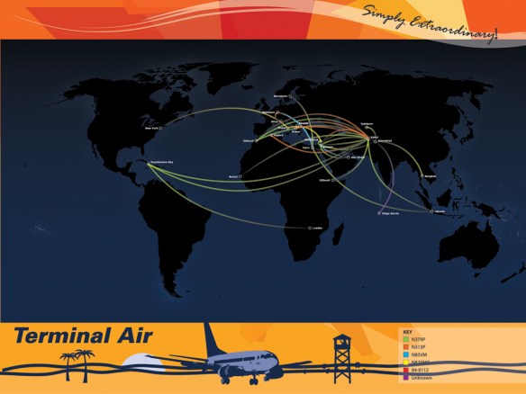
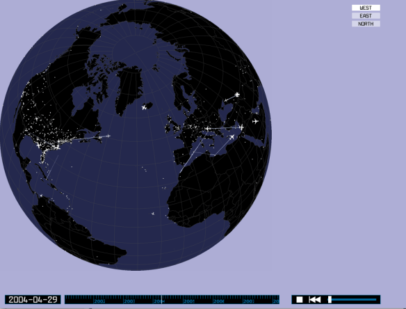
There have been several attempts to reconstruct the geography of the CIA’s program of extraordinary rendition. I’ve long admired the work of my good friend Trevor Paglen, described in his book with A.C. ThompsonTorture Taxi: on the trail of the CIA’s rendition flights, available in interactive map form through Trevor’s collaboration with the Institute for Applied Autonomy as Terminal Air. (I’ve commented on the project before, here and especially here).

terminal-air

And you can only applaud Trevor’s chutzpah is displaying the results of his work on a public billboard:

paglenemerson-cia-flights-2001-6

The project, which involved the painstaking analysis of countless flight records and endless exchanges with the geeks who track aircraft as a hobby, triggered an installation in which the CIA was reconfigured as a ‘travel agency‘:

Terminal Air travel agency

At the time (2007), Rhizome – which co-sponsored the project – explained:

Terminal Air is an installation that examines the mechanics of extraordinary rendition, a current practice of the United States Central Intelligence Agency (CIA) in which suspected terrorists detained in Western countries are transported to so-called “black sites” for interrogation and torture. Based on extensive research, the installation imagines the CIA office through which the program is administered as a sort of travel agency coordinating complex networks of private contractors, leased equipment, and shell companies. Wall-mounted displays track the movements of aircraft involved in extraordinary rendition, while promotional posters identify the private contractors that supply equipment and personnel. Booking agents’ desks feature computers offering interactive animations that enable visitors to monitor air traffic and airport data from around the world, while office telephones provide real-time updates as new flight plans are registered with international aviation authorities. Seemingly-discarded receipts, notes attached to computer monitors, and other ephemera provide additional detail including names of detainees and suspected CIA agents, dates of known renditions, and images of rendition aircraft. Terminal Air was inspired through conversations with researcher and author Trevor Paglen (Torture Taxi: On the Trail of the CIA’s Rendition Flights – Melville House Publishing). Data on the movements of the planes was compiled by Paglen, author Stephen Grey (Ghost Plane: The True Story of the CIA Torture Program – St. Martin’s Press) and an anonymous army of plane-spotting enthusiasts.

There’s a short video documenting the project on Vimeo here and embedded below (though strangely Trevor isn’t mentioned and doesn’t appear in it):

Although Trevor subsequently explained why he tried to ‘stay away from cartography and “mapping” as much as possible’ in his work, preferring instead the ‘view from the ground’, the cartography of all of this matters in so many ways – from the covert complicity of many governments around the world in a global geopolitics of torture through to the toll exerted on the bodies and minds of prisoners as they were endlessly shuffled in hoods and chains over long distances from one black site to another.

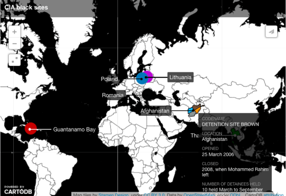
And now, thanks to the equally admirable work of the Bureau of Investigative Journalism, it’s possible to take the analysis even further.  Here is Crofton Black and Sam Raphael introducing their project, ‘The boom and bust of the CIA’s secret torture sites‘:

In spring 2003 an unnamed official at CIA headquarters in Langley sat down to compose a memo. It was 18 months after George W Bush had declared war on terror. “We cannot have enough blacksite hosts,” the official wrote. The reference was to one of the most closely guarded secrets of that war – the countries that had agreed to host the CIA’s covert prison sites.

Between 2002 and 2008, at least 119 people disappeared into a worldwide detention network run by the CIA and facilitated by its foreign partners.

Lawyers, journalists and human rights organisations spent the next decade trying to figure out whom the CIA had snatched and where it had put them. A mammoth investigation by the US Senate’s intelligence committee finally named 119 of the prisoners in December 2014. It also offered new insights into how the black site network functioned – and gruesome, graphic accounts of abuses perpetrated within it.

Many of those 119 had never been named before.

The report’s 500-page summary, which contained the CIA official’s 2003 remarks, was only published after months of argument between the Senate committee, the CIA and the White House. It was heavily censored, while the full 6,000-page study it was based on remains secret. All names of countries collaborating with the CIA in its detention and interrogation operations were removed, along with key dates, numbers, names and much other material.

In nine months of research, the Bureau of Investigative Journalism and The Rendition Project have unpicked these redactions to piece together the hidden history of the CIA’s secret sites. This account unveils many of the censored passages in the report summary, drawing on public data sources such as flight records, aviation contracts, court cases, prisoner testimonies, declassified government documents and media and NGO reporting.

Although many published accounts of individual journeys through the black site network exist, this is the first comprehensive portrayal of the system’s inner dynamics from beginning to end.

CIA black sites (BOIJ:REndition Project)

At present the mapping is rudimentary (see the screenshot above), but the database matching prisoners to black sites means that it ought to be possible to construct a more fine-grained representation of the cascade of individual movements.  The Rendition Project has already identified more than 40 rendition circuits involving more than 60 renditions of CIA prisoners: see here and the interactive maps here.

Tortured geographies

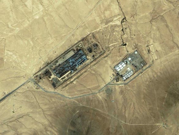
Guantanamo 'Suicides' In what now seems another life, I wrote about US torture during the early years of the “war on terror”, in ‘The Black Flag’ (which was specifically about Guantanamo, and which opened with three ‘suicides’ that we now have good reason to believe were anything but: see here and here) and ‘Vanishing Points’ (which extended the argument to Abu Ghraib and the archipelago of black sites like the ‘Salt Pit’ [shown below] within the global war prison).  Both are available in their original forms under the DOWNLOADS tab, and form part of the material I’ve been working with for a new essay to be included in The everywhere war.

Salt Pit

cia-report-p1-normalNow I’m digesting the Executive Summary that has been released by the Senate Select Committee on Intelligence on the CIA’s Detention and Interrogation Program, but you can download the original (redacted) summary here, ‘Other Views’ here, and the Minority View from the Republicans – and please God it remains a minority view – here.

The New York Times‘ coverage is here, the Washington Post‘s here, and the Guardian‘s here.

In the meantime, some of the best work on the dispersed geography of this vast apparatus was carried out by Trevor Paglen (see my updated discussion here).

map_paglen_emerson_r1_c1

Readers of his Blank spaces on the map will know of Trevor’s own attempt to see the ‘Salt Pit’ for himself, on the ground rather than from the air, and the images that result from this dimension of his work make clear – in plain sight, so to speak – their constitutive difficulties: see, for example, Jonah Weiner‘s essay on his work, ‘Prying eyes’, that appeared in the New Yorker here.

But here is part of what Trevor had to say about the mappings like the one above involved in his Torture Taxi and Terminal Air projects in An Atlas of Radical Cartography:

I’ve actually tried to stay away from cartography and “mapping” as much as possible in my work. The “God’s eye” view implicit in much cartography is usually not helpful in terms of describing everyday life, nor in describing the qualities of the relationships that cartography depicts. Because of what cartography cannot represent… it becomes pretty clear why it (and the forms of power that the cartographic viewpoint suggests) have traditionally been such powerful instruments of both colonialism and the contemporary geopolitical ordering of the world (which of course very much comes out of colonialism)…

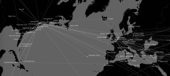
I tend to be far more attracted to “on the ground” viewpoints and to embrace their fragmentedness and incompleteness. This project, as well as the “Terminal Air” project with the Institute for Applied Autonomy, are of course notable exceptions. With both of these projects that use the cartographic viewpoint, I was interested in taking what might seem like a familiar image and trying to and make it strange – trying to capture the feeling I had when I first started following CIA flights: it was the constant domestic flights to places like Tulsa, Las Vegas, Fresno, Fort Lauderdale and such that made a big impression on me. In working with John Emerson and the IAA, I insisted that we try to show a continuum between the domestic landscape and the landscape “somewhere else.” Neither of these projects are in my view not particularly useful as didactic tools but are instead useful in helping to see the point that we talked about above: that the “darkest” spaces of the war on terror blur into the everyday landscapes here “at home” and are in many way mutually constitutive. In this sense, they’re … images rather than analytic tools.

As I’ve noted before, this is part of the ‘capture’ side of the US kill-capture apparatus that uses drones (and often Special Forces) for the ‘kill’.  I say ‘US’, but it’s clear – not least from the map above – that a network of other states that radiates far beyond the other ‘Five Eyes‘ which have been so deeply involved in providing geospatial intelligence for drone strikes (and more) has been complicit in the production and concealment of this global archipelago of torture.

But there’s an irony in all this: even as the Obama administration ramped up drone strikes – and after a lull they have been resumed with a vengeance in Pakistan’s Federally Administered Tribal Areas – it was also condemning torture and, last month, committed the United States to acknowledging the extraterritorial reach of the Convention Against Torture (see Sarah Cleveland at Just Security here and Ryan Goodman and Eric Messenger here).  The refusal of the Bush administration to do so was a central part of the argument about legal geographies that I developed in both ‘The Black Flag’ and ‘Vanishing Points’.

So now we have an administration that recognises extra-territoriality to proscribe torture – and insists on it (or its own version of extra-territoriality) to authorise targeted killing.

I still haven’t found what I’m looking for

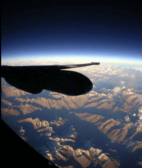
U2 (USAF photograph)

Rummaging around for more people working on militarized vision, I encountered a forum on Military optics and Bodies of difference held at Berkeley’s Center for Race and Gender earlier this year, and through that the research of Katherine Chandler, who holds a Townsend Center for the Humanities Dissertation Fellowship in the Department of Rhetoric.  Her dissertation in progress is entitled Drone Flight and Failure: the United States’ Secret Trials, Experiments and Operations in Unmanning, 1936 – 1973, which promises to fill in a crucial gap in conventional genealogies of today’s remote operations.

As you’ll see if you visit her website here, Katherine is an accomplished artist as well as researcher and critic.  You can read her essay on ‘System Failures’, which includes a discussion of Trevor Paglen‘s Drone Vision and Omer Fast‘s 5,000 Feet is the Best, at The New Inquiry (August 2012) here, and find a fuller discussion of Fast’s video situated within what Katherine calls the ‘knowledge politics’ and political ecologies of remote operations on pp. 63-74 of Knowledge politics and intercultural dynamics here.

Here is the abstract for her talk at the forum, Unmanning Politics: Aerial Surveillance 1960-1973:

u2_spy_plane_incident_newspaper_clippingOn May 1, 1960, Francis Gary Powers’ U-2 plane was shot down over the Soviet Union while on a secret reconnaissance mission. The ensuing diplomatic fallout caused the cancellation of the Paris Summit between Dwight Eisenhower and Nikita Khrushchev. Less well known, in April 1960, Robert Schwanhausser, an engineer for Ryan Aeronautical, briefed the United States Air Force on the possibility that its Firebee target drone, used at the time for air defense training, might be re-engineered as an unmanned reconnaissance plane. In the weeks following the Powers incident, the Air Force began wholesale negotiations with Ryan Aeronautical to develop a pilotless spy plane and, on July 8, 1960, the company was given funding to begin the project. Among the noted advantages were: “political risk is minimized due to the absence of a possible prisoner” (“Alternative Reconnaissance System,” 1960). I investigate the resulting Lightning Bugs, flown for three-thousand reconnaissance missions in Southeast Asia between 1964 and 1973. 

Researching how aircraft were unmanned during the Cold War is instructive both in the ways they mimic contemporary unmanned combat aerial vehicles and trouble assumptions about them. I follow how unmanned systems operated within the logics of American Cold War politics and their perceived usefulness geopolitically – crossing borders as spy aircraft, collecting and jamming electronic signals, and gathering battlefield reconnaissance. I ask how conquest, and the ensuing assumptions of empire, colonialism and race, underlie the unmanning of military aircraft, even while these aspects were purposefully, although, unsuccessfully occluded through the idea that technologies could mitigate political risks. Moreover, unmanned reconnaissance projects were cancelled at the end of the Vietnam War and their failure provides clues about what might be left out of visions of aerial control and the ways politics, and human vulnerabilities, persisted in spite of efforts to engineer systems that would suggest otherwise.

The legitimacy of contemporary drone strikes relies on the ability of unmanned aircraft to “see” enemy targets. Yet, as Isabel Stengers has argued, any representation gives value. Looking at the few available images from these early unmanned reconnaissance flights, I move between what is seen and unseen to examine how values, particularly, secrecy and control, are formed through unmanned reconnaissance. Claiming to produce a mechanical, rather than political, view of the territories surveyed, I show how the supposedly apolitical lens of the drone occludes how politics, industry and military come together to privilege certain positions and target others.

Interesting stuff – especially that first paragraph linking ‘un-manning’ to the U-2.  There is a strange irony here, because until this year the US Air Force had in fact favoured its fleet of 33 U-2 (‘Dragon Lady’) aircraft [one of which is shown at the top of the photograph] over the high-altitude Global Hawk [shown at the bottom], so much so that it had asked for permission to cancel its orders for the new Block 30 Global Hawks and place others in storage.

GlobalHawk_USAFAirmanFirstClassBobbyCummings

You may be surprised to discover that the U-2 is still flying, but the airframe has been repeatedly modified and so too has the network in which it is embedded.  One pilot explained:

“The U-2 started out only carrying a wet-film camera. Now, with today’s technology, I’m alone up there, but I may be carrying 40 to 50 Airmen via data link who are back at a (deployable ground station).”

U-2 flying hours in Afghanistan and Iraq (New York Times)It’s important to remember that Predators and Reapers are not the only platforms streaming imagery to the Air Force’s Distributed Common Ground System.  The U-2 was given a new lease of life by the Gulf War in 1991, when nine U-2s flying out of the UAE  provided 50 per cent of all imagery and over 90 per cent of all ground forces targeting imagery.  During the invasion of Iraq in 2003 U-2s flew only 19 percent of the air reconnaissance missions, but they provided more than 60 per cent of the signals intelligence and 88 per cent of battlefield imagery.  The continuing wars in Afghanistan and Iraq confirmed that the U-2’s original, strategic significance had been eclipsed by its new tactical role.  Chris Pocock explains:

“The U-2 today is more a tactical intelligence gatherer…  It supports ground operations on a daily basis, flying over Afghanistan, flying around Korea, flying in the eastern Mediterranean, doing all those things every day and it’s actually not only providing intelligence that is analyzed for the benefit of those ground troops, but it’s actually in contact with those ground troops in real time.”

And that close contact – akin to the intimacy remote operators in the continental United States claim when they say they are not 7,000 miles but 18 inches from the battlespace, the distance from eye to screen – takes its toll on the U-2 pilots too.  In addition to the extraordinary pressures flying the U-2 imposes on their bodies, one USAF physician insisted that ’emotionally… they’re wrung out from that… When you’re talking to somebody on the radio and there’s gunfire in the background… you’re not taking a nap while that’s happening.’

Writing in the New York Times, Christopher Drew provided a revealing example:

Major Shontz said he was on the radio late last year with an officer as a rocket-propelled grenade exploded. “You could hear his voice talking faster and faster, and he’s telling me that he needs air support,” Major Shontz recalled. He said that a minute after he relayed the message, an A-10 gunship was sent to help.

In fact, that last clause can be generalised; the U-2 has often been deployed in close concert with other platforms, including Predators and Reapers.  Drew again:

The U-2’s altitude [70,000 feet or more], once a defense against antiaircraft missiles, enables it to scoop up signals from insurgent phone conversations that mountains would otherwise block.  As a result, Colonel Brown said, the U-2 is often able to collect information that suggests where to send the Predator and Reaper drones, which take video and also fire missiles. He said the most reliable intelligence comes when the U-2s and the drones are all concentrated over the same area, as is increasingly the case.

Part of the reason for that is that the U-2 has such an advanced imagery system:

Even from 13 miles up its sensors can detect small disturbances in the dirt, providing a new way to find makeshift mines [IEDs] that kill many soldiers.  In the weeks leading up to the [2010] offensive in Marja, military officials said, several of the … U-2s found nearly 150 possible mines in roads and helicopter landing areas, enabling the Marines to blow them up before approaching the town.

Marine officers say they relied on photographs from the U-2’s old film cameras, which take panoramic images at such a high resolution they can see insurgent footpaths, while the U-2’s newer digital cameras beamed back frequent updates on 25 spots where the Marines thought they could be vulnerable.

U-2 preparing for takeoff 'in SW Asia' (USAF/Eric Harris)

For all that,  in the last two years the Air Force’s plan to cut the Global Hawk program was repeatedly over-ridden by Congress, in response to an extraordinary campaign waged by Northrop Grumman, which launched what Mark Thompson called ‘its own ISR – intelligence, surveillance and reconnaissance – mission over Capitol Hill to decide where to strategically target cash-bombs to keep its plane, and more of them, flying for another day’: you can find a  full report at the Center for Public Integrity here.

The Air Force has now accepted the retirement of Lockheed Martin’s ageing Cold warrior, because (so it says) the cost per flying hour of the Hawk has now fallen below that of the U-2 ($24,000 vs. $32,000).  ‘U2 shot down by budget cuts’, is how PBS put it, while the Robotics Business Review triumphantly announced ‘Here comes automated warfare’.

Even so, cost per flying hour is not the whole story, as Amy Butler explains.  Part of the problem is logistical and, by extension, geopolitical: ‘Global Hawks based in Guam have to transit for hours just to reach North Korea, whereas the U-2, based at Osan air base, South Korea, has a shorter commute’ (details of the Hawk’s global basing can be found here).

A second issue is reliability, which bedevils all major UAVs and makes cost per flying hour a dubious index:

‘Intelligence, surveillance and reconnaissance collection is in high demand, and aircraft downtime is extremely worrisome for combatant commanders. In the Pacific, 55% of Global Hawk’s missions were canceled in fiscal 2013; 96% of the U-2’s missions were achieved. The U-2 was also scheduled for nearly three times as many missions. Global Hawk lacks anti-icing equipment and is not able to operate in severe weather.’

Finally, critics continue to complain that the sensors on the U-2 remain superior to those on the Hawk and provide a wider field of view.  According to a report from Eric Beidel,

The Global Hawk carries Raytheon’s Enhanced Integrated Sensor Suite, which includes cloud-penetrating radar, a high-resolution electro-optical digital camera and an infrared sensor. But the U-2’s radar can see farther partly because the plane can fly at altitudes over 70,000 feet, about 10,000 feet higher than a Global Hawk. A longer focal length also gives the U-2’s camera an edge, experts said…

Air Force Chief of Staff Gen. Norton Schwartz has said that the drone’s sensors just weren’t cutting it. Further, the U-2 can carry a larger payload, up to 5,000 pounds compared to 3,000 pounds for the Global Hawk.

“Some of the most useful sensors are simply too big for Global Hawk,” said Dave Rockwell, senior electronics analyst at Teal Group Corp. He referred to an optical bar camera on the U-2 that uses wet film similar to an old-fashioned Kodak. “It’s too big to fit on Global Hawk even as a single sensor.”

All of these technical considerations are also political ones, as Katherine’s abstract indicates, and none of them answers the other questions she poses about what can and cannot be seen…

Seeing Machines

VIRILIO Vision machineIn a series of posts on photography Trevor Paglen provides some ideas that intersect with my own work on Militarized Vision and ‘seeing like a military’.  First, riffing off Paul Virilio, Trevor develops the idea of photography as a ‘seeing machine‘:

‘Seeing machines is an expansive definition of photography. It is intended to encompass the myriad ways that not only humans use technology to “see” the world, but the ways machines see the world for other machines. Seeing machines includes familiar photographic devices and categories like viewfinder cameras and photosensitive films and papers, but quickly moves far beyond that. It embraces everything from iPhones to airport security backscatter-imaging devices, from electro-optical reconnaissance satellites in low-earth orbit, to QR code readers at supermarket checkouts, from border checkpoint facial-recognition surveillance cameras to privatized networks of Automated License Plate Recognition systems, and from military wide-area-airborne-surveillance systems, to the roving cameras on board legions of Google’s Street View” cars.

What’s more, the idea of seeing machines I’m sketching out here isn’t confined to the imaging devices and systems I’ve described in broad strokes. The definition extends to include the images (or data) produced by such imaging systems, the digital metadata associated with those images, as well as additional systems for storage, archiving, search and interpretation (either human or algorithmic). Finally, and crucially, seeing machines encompasses not only imaging systems, search, and storage capacities, it encompasses something a bit more abstract, namely the “styles” or “practices” of seeing that different imaging systems enable (i.e. the difference between what a view camera and an automated license-plate reading camera “want” to do and how they see the world differently).  Crucially, the definition of photography I’m proposing here encompasses imaging devices (“cameras” broadly understood), the data (“images” being one possible manifestation of that data) they produce, and the seeing-practices with which they are enmeshed.’

In a subsequent post on Geographies of Photography Trevor then links these seeing-practices to what he calls the production of space (and what I now prefer to think of as performances of space), and uses the example of the Reaper to illustrate what he has in mind:

What exactly is a Reaper drone? In essence, it’s a camera attached to a remote-controlled airplane. Sometimes it carries missiles. What’s particular about a Reaper drone (and other drones in its larger family, including the Predator and the Sentinel) is that airplane, pilot, navigator, analysts, and commander don’t have to be in the same place. The aircraft might be flying a combat mission in Yemen by a pilot based in Nevada, overseen by a manager in Virginia, and supported by intelligence officers in Tampa (geographer Derek Gregory has written about what he calls “Drone Geographies.”) The drone creates its own “relative” geographies, folding several noncontiguous spaces around the globe into a single, distributed, “battlefield.” The folding of space-time that the Reaper drone system enables is a contemporary version of what Marx famously called the “annihilation of space with time,” i.e. the ability to capitalize on the speed of new transportation and communications technologies to bring disparate spaces “closer” together, relatively speaking.

I think that’s more or less right: these new, networked political technologies of vision have been instrumental in the production of a non-linear and discontinuous battlespace, threaded by wormholes that connect one site to another.  But, as I’ll try to show when I eventually get to my post on Uruzgan, the process is far from seamless, the folds are more fragile than most of us realise, and the discontinuities and ruptures are as important as the connections for the administration of military violence.

(in)Humanity and drones

SATIA Spies in ArabiaThe latest issue of Humanity: an international journal of human rights, humanitarianism and development 5 (1) (2014) – see my previous post here – contains a wonderful dossier on Drones between past and present.  It includes Priya Satia, whose work I’ve admired ever since I read her wonderful Spies in Arabia: The Great War and the Cultural Foundations of Britain’s Covert Empire in the Middle East, on ‘Drones: a history from the Middle East’ (pp. 1-31), Anna Chotzen on ‘Beyond bounds: Morocco’s Rif War and the limits of international law’ (pp. 33-54: ‘From a legal standpoint, the United States’ drone offensives are eerily similar to Spain’s chemical war in Morocco a century ago’), and a Photo Esssay from Trevor Paglen (pp. 57-71), introduced by Nicholas Guilhot (pp. 55-56).

Priya’s essay is of particular interest to me, since it recovers the genealogy and, crucially, what she calls ‘the cultural history of bombardment’ that connects colonial practices of ‘air control’ to the ideologies that activate the drone strikes prosecuted by the US in Afghanistan, Pakistan and elsewhere.  She’s more sanguine about the transparency of those carried out by the USAF in Afghanistan than I am:

‘… in my conversations with military officers, it is clear how strongly the USAF wishes to distinguish its use of drones from ‘‘other agencies’ ’’ use of them, even while acknowledging that tactics are shared. The USAF’s drone strikes in Afghanistan are transparent; a JAG (judge advocate) assesses the proportionality of the action and the likelihood of collateral damage; official casualty figures line up well with independent counts.’

I now suspect it’s more than ‘tactics’ that are shared, and the lines between the USAF and the CIA are more blurred than – I agree – most military officers would wish.  And my project on ‘Militarized vision‘ is trying to identify the parameters within which the USAF’s transparency and its visual mediations operate.  But as she goes on to say, ‘However, all of this hardly matters politically, given the older and more recent history of aerial counterinsurgency in these regions.’  And she provides a rich and compelling account of that history and its traces in present memories and (para)military practices.

PAGLEN Untitled (Predator drone) 2013

Eyes in the sky, boots on the ground

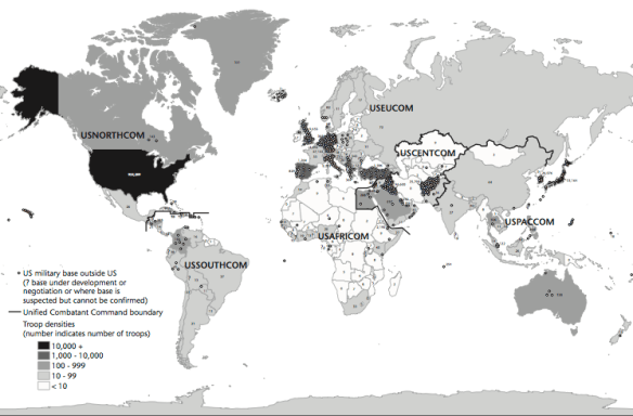
When I was working on my ‘War and peace’ essay (Trans Inst Br Geogr 35 (2010) 154–186; DOWNLOADS TAB) – which will appear, in radically revised and extended form, in The everywhere war – I included this map of US military bases outside the continental United States, based on David Vine‘s Island of shame: The Secret History of the U.S. Military Base on Diego Garcia (2009), which was in turn derived from the Pentagon’s 2007 Base Structure Report:

US military bases

Various other versions are available around the web, but now – inspired in part by Trevor Paglen‘s Blank Spots on the Map – a new project by Josh Begley (of Dronestream fame) has worked from the 2013 Base Structure Report to produce a new base map supplemented by aerial/satellite imagery of more than 640 US military bases around the world.

It’s still a minimalist accounting, but the lacunae are produced not only by the secret installations that are systematically excluded from the Pentagon’s public accounting of what it calls its ‘real property’  – if only there could be a listing of its surreal property too (which is where Trevor comes in) – but also by the database’s predisposition towards permanence (of sorts).  You’ll see what I mean if you zoom in on Afghanistan: the main Forward Operating Bases are there but none of the firebases and combat outposts scattered across the landscape.  Still, even in this appropriately skeletal form, it’s a vivid reminder of the boots firmly planted on other people’s ground.

BEGLEY How do you measure a military footprint?

Josh includes a sharp-eyed commentary on the differences between images of the same site on different commercial platforms, and concludes his opening essay, ‘How do you measure a military footprint?’ like this:

Taken as a whole, I’d like to think this collection can begin to approximate the archipelago of militarized space often understood as empire. But I’m hesitant to say that. It seems to me that empire involves more than pushpins on a map. It is made up of human activity — a network of situated practices that preclude constellational thinking and sculpt geographies in their own image.

I’m not sure aerial photography can get at that complexity. But perhaps an outline of this footprint– of runways and bases and banal-looking buildings — might begin to chip away at the bumper-sticker simplicity much political discourse about the military-industrial complex gets reduced to.

A friend recently sent me this passage from Ananya Roy [‘Praxis in the time of Empire’, Planning Theory 5 (1) (2006) 7-29] that I’ve come to like quite a bit:

“The time of empire is war and destruction, but it is also creation, beauty, and renewal. The apparatus of empire is the military, but it is also architecture, planning, and humanitarian aid. The mandate of empire is to annihilate, but it is also to preserve, rebuild, and protect. Empire rules through coercion and violence, but it also rules through consent and culture.”

HAFFNER The view from aboveTwo quick comments.  First, if you want more on what aerial photography can get at – and in particular its historical formation as an indispensable vector of modern war – try Terrence Finnegan‘s Shooting the Front: Allied aerial reconnaissance in the First World War (2011), which has already established itself as a classic, or if you prefer a more theoretically informed survey, Jeanne Heffner‘s  The view from above: the science of social space (2013), especially Chapter 3, ‘The opportunity of war’.  War doesn’t loom as large as you’d think in Denis Cosgrove and William Fox‘s Photography and flight (2010), but you’ll also find interesting ideas in Paul Virilio‘s perceptive War and cinema.  On satellite imagery, the most relevant essay for the background to this project is probably Chris Perkins and Martin Dodge, ‘Satellite imagery and the spectacle of secret spaces‘, Geoforum 40 (4) (2009) 546-60.  The different platforms that Josh discusses (Google Earth and Bing) derive much of their imagery from DigitalGlobe: for an update on its new super-high res WorldView-3 (and its restriction to the US military and security apparatus), see Neal Ungerleider, ‘Google Earth, foreign wars and the future of satellite imagery’ here.  Among her many important essays, Lisa Parks‘ ‘Zeroing in: overhead imagery, infrastructure ruins and datalands in Iraq and Afghanistan’ is an indispensable kick-start for thinking about satellite imagery and military violence, and you can find it in Jeremy Packer and Stephen Crofts Wiley (ed) Communication matters (2013) and in Nicholas Mirzoeff‘s Visual culture reader (3rd edition, 2013).  One of my favourite essays – and the one that got me started on the intimate connections between political technologies of vision and military violence an age ago – is Chad Harris‘s ‘The omniscient eye: satellite imagery, “battlespace awareness” and the structures of the imperial gaze’, open access at Surveillance and society 4 (1/2) (2006) here.

Second, it is indeed important to think through all the ways in which the US military/security presence reaches beyond these pinpricks on the map.  These are bases for more extensive military operations, obviously, but there is also the roving US presence in outer space, air and ocean – and cyberspace – that is necessarily absent from these static arrays.  In addition – and there must be many other add-ons –  the US is hardening its borders in a transnational space, confirming the argument made explicit in the 9/11 Commission report: ‘the American homeland is the planet’.  Deb Cowen‘s seminal essay on ‘A geography of logistics’ is indispensable here, and Todd Miller provides a recent vignette on what he calls Border Patrol International here.

Oh – one more thing.  Josh’s new project has been widely advertised – from Gizmodo through the Huffington Post to the Daily Mail (really) – but if you want to see whether you’re in step with other posters and the trolls, look at the comments sections.  Sobering.  Gizmodo is particularly revealing/depressing.

Militarized vision

Before I started my odyssey through Grégoire Chamayou‘s Théorie du drone (which will continue next week), I had discussed multiple ways of thinking about the relations between visualities, political technologies of vision and drones.  Much of the work that I pointed to takes place in the borderlands between investigative journalism and visual art: hence my interest in (for example) James Bridle, Omer Fast, and Trevor Paglen (for a quick review and further links, see here).

Two additional essays have crossed my screen, appropriately enough, which contribute to these discussions.

The first is Matt Delmont‘s ‘Drone encounters: Noor Behram, Omer Fast and visual critiques of drone warfare’ [American Quarterly 65 (1) (2013) 193-202]:

‘Drones draw their deadly power from …  twin claims to visual superiority: the ability to see and to resist being seen.  At the same time, however, artists, scholars, and human rights activists have used the visual to contest the expansion of the drone program.’

The first of these, as Tim Mitchell showed in his classical expositions of what, following Heidegger, he called ‘the-world-as-exhibition’ (which has continued to haunt much of my work since Geographical Imaginations), is a profoundly – and appropriately – colonial/imperial impulse.  You can find a suggestive discussion of Heidegger’s original exposition of ‘the conquest of the world as picture’ directed specifically at today’s drone wars in Joseph Pugliese‘s ‘Prosthetics of law and the anomic violence of drones’ [Griffith Law Review 20 (2011) 931-61] and, eventually (!), an extended account in The everywhere war.

What interests Matt is the critical ability to reverse the impulse – to make the unseen seen/scene – and turn the visual back on itself, and that’s exactly the point sharpened in exquisite detail in Henrik Gustafsson‘s ‘Foresight, hindsight and state secrecy in the American West: the geopolitical aesthetics of Trevor Paglen’ [Journal of visual culture 12 (2013) 148-164]:

‘Combining geographic research and artistic practice, self-professed ‘experimental photographer’ Trevor Paglen implements such a dialectical method in his ongoing project to map and photograph the sprawling black sites of the US military and intelligence community. Paglen’s images rarely show human agents, other than the blurry figures boarding an unmarked aircraft, or the blackened-out faces on fake passports. It is concerned, instead, with the agency of space. Moving between imaginative geographies and what Paglen refers to as ‘facts on the ground’, it investigates how the former produces the latter, how imaginative geographies materialize.’

It’s a beautifully realised reading that pays particular attention to what geographer Don Mitchell famously called ‘the lie of the land‘.  In Don’s terms, this was the extraordinary capacity of the landscape – as at once material fabrication and enframed visuality – to conceal through its very physicality the work involved and embodied in its production.  In much the same way, Henrik suggests, Trevor’s work offers a series of strategic reversals, détournements, of the ‘dark geography’ of the national security state inscribed in and on the landscape (and the skyscape).

Paglen Untitled (Reaper Drone)

As my last post showed, I hope, my interest in the aesthetic-imaginative has not diminished my commitment to the archival-documentary (or my admiration for projects like these or Oppenheimer’s The Art of Killing that so artfully bleed the one into the other).

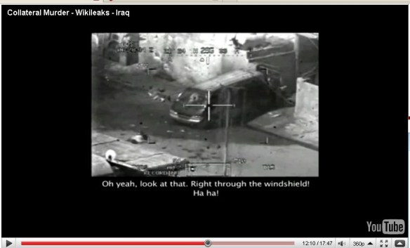
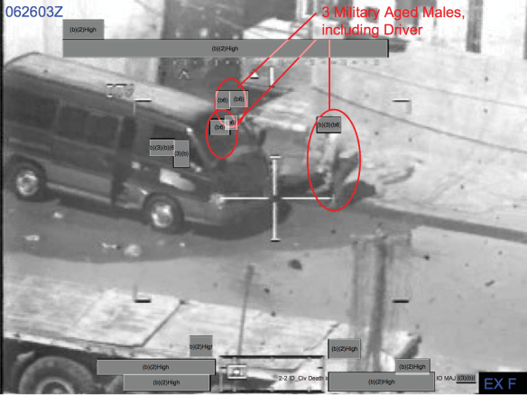
In that vein, I’ve returned to the incident I discussed last time – the US combat helicopter attack on unarmed civilians in New Baghdad in July 2007 – and started to compare what happened there with the even deadlier attack on three vehicles carrying civilians down a dusty mountain road in Uruzgan, Afghanistan in February 2010 which I discussed in “From a view to a kill” (DOWNLOADS tab) (that strike was also carried out by US attack helicopters, but the vital ‘visual responsibility’ was the work of a surveillant Predator crew.)

Collateral Murder2

My intention is to work towards an extended essay on ‘Militarized vision‘ that will, I hope, take critiques of the politics of vision beyond the full motion video feeds from drones. I’m working my way through transcripts of both incidents, the video clip of the Baghdad attack released by Wikileaks, and the military’s own investigations of both incidents.  The interrogations and conclusions from the investigations are crucial, I think, not only for providing additional information and even insight, but also for adding an understanding of the juridical layer involved in the scopic regimes at work.  The reports have much to tell us about what flight crews and ground troops saw (and didn’t see) on the days in question (above) and about what is possible for the military to see (and not see) after the event (below).  I’d already worked my way through the Uruzgan investigation in detail for The everywhere war, but re-reading it alongside what Wikileaks called “Collateral Murder” is proving to be an illuminating exercise.

New Baghdad %22MAM%22

More later, though my next posts on Chamayou (and what will be a separate post on the juridical individuation of later modern war) will provide some of the necessary context.

Dead streaming

Readers who have followed Josh Begley‘s Dronestream project – which I commented on here  – will be interested in this video of his graduate thesis presentation at NYU:

It’s a tour de force in under 15 minutes.  Josh begins with a rapid-fire overview of over 480 more or less covert US drone strikes in 10 years killing more than 4,700 people.  ‘What can our relationship be with this story?’ he asks.

His first attempt at finding an answer was the Drones+ app that was intended to send a notification to your iPhone every time news broke of a drone strike in Pakistan, Yemen or Somalia.  Like James Bridle‘s Dronestagram (which enabled satellite images of the sites of remote strikes to be viewed on an iPhone), it was a way of projecting the remoteness of the strikes into the intimacy of our own life-worlds.  But  Drones+ was more demanding precisely because its episodic notifications made those strikes more insistent, more interruptive.  Hence Josh’s key question:

‘Do we really want to be as connected to our foreign policy as we are to our smart phones?  … which are these increasingly intimate devices, the places where we share pictures of or loved ones and communicate with our friends, the things that we pull out of our pockets when we’re lost and which auto-magically put us at the center of the map……  Do we really want these things to be the site of how we experience remote war?’

Apple’s answer was no, as he ruefully acknowledges, though I suspect that would also be the answer of many others too: that, after all, is the appeal of remote wars to those who orchestrate them.  Out of sight, out of mind: which is precisely why there is also something ‘auto-magical’ about Josh’s determination to ‘détourne‘ these remote technologies like this.

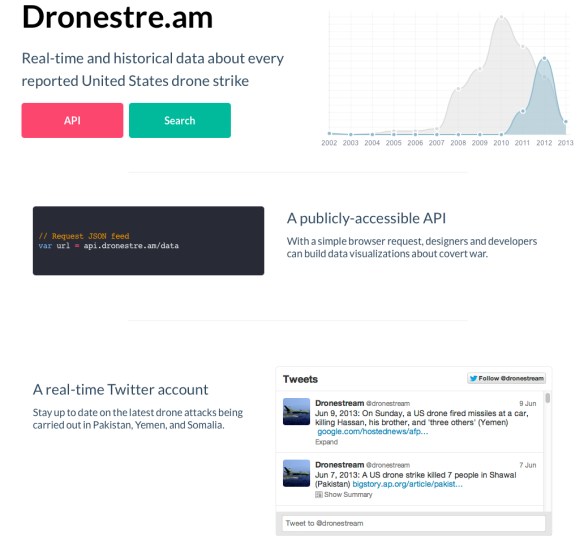
Josh’s next step was to use a Twitter account to start to tweet every recorded drone strike, which eventually morphed (via the aggregations of the Bureau of Investigative Journalism) into Dronestream: or, more accurately, Dronestre.am.

Dronestre.am

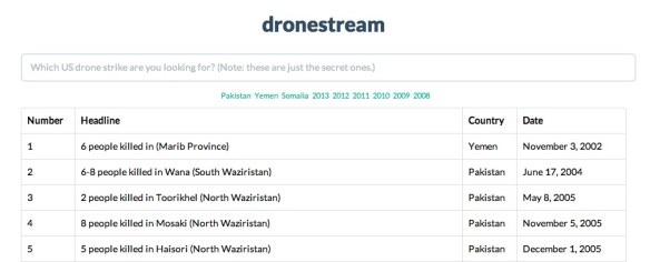
This is a publicly accessible API (Application Programming Interface) that enables the data set to be interrogated and visualized in multiple ways (and if you want a simple account of working with the API, check out Felix Haas here):

dronestream

Josh credits Trevor Paglen‘s ‘spatial analysis’ and his ongoing attempts to outline the Blank Spots on the Map as a particular inspiration for his work.  What he has sought to do, by extension, is to map ‘the blank spots in the data’: to recover what he calls ‘the negative space that these drone strikes take up’, and so enable complex stories and ordinary voices to emerge out of the swirl of Big Data.  In doing so, he argues that it becomes possible to ‘speak back’ to the drones and to the masters of dirty wars that control them, in effect artfully turning this latest version of techno-war against itself.

The trick now is to fill out these ‘blank spots on the map’, to recover the insistently human geographies that are devastated by these air strikes and the threat of more to come, so that we can overturn both the ‘face-less’ and the ‘place-less’ narrative of the covert war machine.  It thrives on being both out of sight and out of site, and Josh’s research is invaluable in reminding us that the virtual technologies that make its depredations possible are also acutely material in their form and in their effects.

Black spots and blank spots

Over at Guernica, Trevor Paglen has a short essay on the rise of what he calls ‘the terror state’ that connects the dots between several recent posts:

For more than a decade, we’ve seen the rise of what we might call a “Terror State,” of which the NSA’s surveillance capabilities represent just one part. Its rise occurs at a historical moment when state agencies and programs designed to enable social mobility, provide economic security and enhance civic life have been targeted for significant cuts. The last three decades, in fact, have seen serious and consistent attacks on social security, food assistance programs, unemployment benefits and education and health programs. As the social safety net has shrunk, the prison system has grown. The United States now imprisons its own citizens at a higher rate than any other country in the world.

While civic parts of the state have been in retreat, institutions of the Terror State have grown dramatically. In the name of an amorphous and never-ending “war on terror,” the Department of Homeland Security was created, while institutions such as the CIA, FBI and NSA, and darker parts of the military like the Joint Special Operations Command (JSOC) have expanded considerably in size and political influence. The world has become a battlefield—a stage for extralegal renditions, indefinite detentions without trial, drone assassination programs and cyberwarfare. We have entered an era of secret laws, classified interpretations of laws and the retroactive “legalization” of classified programs that were clearly illegal when they began. Funding for the secret parts of the state comes from a “black budget” hidden from Congress—not to mention the people—that now tops $100 billion annually. Finally, to ensure that only government-approved “leaks” appear in the media, the Terror State has waged an unprecedented war on whistleblowers, leakers and journalists. All of these state programs and capacities would have been considered aberrant only a short time ago. Now, they are the norm.

This ought to be depressingly familiar stuff, though it is important to connect those dots.  I highlight Trevor’s argument here (which radiates far beyond the paragraphs I’ve extracted above) for two reasons.

PAGLEN BLank Spots on the MapFirst, the practices that Trevor disentangles work through distinctively different geographies, at once material and virtual. Trevor’s own work addresses different dimensions of what he’s also called the Blank Spots on the Map – here definitely be dragons! though there’s a delicious irony in the US finding Edward Snowden’s whereabouts (at least this morning) to be one of them. There’s some small comfort to be had in the raging impotence of the state apparatus, which is evidently neither all-seeing nor all-knowing.  As part of his project, Trevor has done much to bring into (sometimes long-distance) focus the prying eyes of the ‘terror state’ – see for example here – but I’m particularly interested in the differential modalities of ‘watching’ and ‘acting’.  The US Air Force has become preoccupied with the predicament of ‘swimming in sensors, drowning in data‘, for example, which makes it exceptionally difficult to convert its enhanced capacity for intelligence, surveillance and reconnaissance into focused strikes and, as I noted earlier, this is only one version of a wider divergence outlined by Peter Scheer:

The logic of warfare and intelligence have flipped, each becoming the mirror image of the other. Warfare has shifted from the scaling of military operations to the selective targeting of individual enemies. Intelligence gathering has shifted from the selective targeting of known threats to wholesale data mining for the purpose of finding hidden threats.

The resulting paradigms, in turn, go a long way to account for our collective discomfort with the government’s activities in these areas. Americans are understandably distressed over the targeted killing of suspected terrorists because the very individualized nature of the drone attacks converts acts of war into de facto executions — and that in turn gives rise to demands for high standards of proof and adjudicative due process.

Similarly, intelligence activities that gather data widely, without fact-based suspicions about specific individuals to whom the data pertain, are seen as intrusive and subject to abuse.

TREVOR PAGLEN Keyhole 12-3 Optical reconnaissance satelliteThis is an interesting suggestion, a simple schematic to think with, and at present I’m working through its implications (and complications) for other dimensions of later modern war – specifically the geographies of cyberwarfare that I briefly outlined in my early essay on ‘The everywhere war’ (DOWNLOADS tab).  So for the book I’m splicing  cyberwarfare into the now explosive debate over surveillance in cyberspace, and the transformation of James Gibson‘s Fordist version of ‘Technowar’ into its post-Fordist incarnation.  In a report for Vanity Fair Michael Joseph Gross calls cyberwarfare ‘silent war’ and ‘war you cannot see’, and yet it too (as Trevor’s work implies) is material as well as virtual, not only in its consequences but also in its very architecture: see, for example, here and here (and the wonderful graphic that accompanies the report).  So, with patience, skill and effort, it can indeed be seen.  And, contrary to Thomas Rid‘s Cyber war will not take place (2013), there is a crucial sense – one which my dear friend Allan Pred constantly emphasised – in which these capacities and activities do indeed take place… More soon.

There’s a second reason for noting Trevor’s essay (he was, not incidentally, a student of Allan’s): it originates from Creative Time Reports edited by Marisa Mazria Katz:

Creative Time Reports strives to be a global leader in publishing the unflinching and provocative perspectives of artists on the most challenging issues of our times. We distribute this content to the public and media free of charge.

Asserting that culture and the free exchange of ideas are at the core of a vibrant democracy, Creative Time Reports aims to publish dispatches that speak truth to power and upend traditional takes on current issues. We believe that artists play a crucial role as thought leaders in society, and are uniquely capable of inspiring and encouraging a more engaged and informed public, whether they are addressing elections or climate change, censorship or immigration, protest movements or politically motivated violence.

In an era of unprecedented interconnectedness, Creative Time Reports provides artists with a space to voice analysis and commentary on issues too often overlooked by mainstream media. We believe in the importance of highlighting cultural producers’ distinctive viewpoints on world events and urgent issues of social justice to ensure a livelier, more nuanced and more imaginative public debate.

Given everything I’ve said about the importance of the arts to creative critical research the relevance of this will, I hope, be obvious: art not simply as a means to represent the results of research but rather as a medium through which to conduct research.  Good to think with, as Lévi-Strauss might have said, but also good to act with.  (More on Creative Time here; they are holding a ‘summit’ on Art, Place and Dislocation in the 21st Century City in New York, 25-26 October 2013).