Base lines and military projections

David Vine has updated his map of the global footprint of the US military over at Politico.

VINE US military bases

I used an early version for my ‘War and Peace’ essay (DOWNLOADS tab), and that map – like this one – was drawn primarily from the annual Base Structure Report, a summary of the US military’s ‘real property inventory’ (all sites owned and managed by the Pentagon).  It’s an unwieldy document which uses a high threshold to filter inclusion:

To qualify for individual entry in the BSR, a DoD site located in the United States must be larger than 10 acres AND have a Plant Replacement Value (PRV) greater than $10 million. If the site is located in a foreign country, it must be larger than 10 acres OR have a PRV greater than $10 million to be shown as a separate entry. Sites that do not meet these criteria are aggregated as an “Other” location within each state or country.

Iraq doesn’t appear in these tabulations – though it is shown on the map – yet the continuing US involvement in the conflict there and across the all-but-erased border in Syria has surely extended its footprint.  As David notes,

‘There were 505 bases at the U.S. occupation’s height, but the Iraqi parliament rejected the Pentagon’s wish to keep 58 “enduring” bases after the 2011 withdrawal. U.S. forces have occupied at least five bases since 2014 and are considering more installations.’

Afghanistan is absent too: ‘By the end of 2014 … the U.S. military will have closed, deconstructed, or vacated most of what were once around 800 military installations, ranging from small checkpoints to larger combat outposts to city-sized bases.’  But the US military retains a significant presence there, and its drones are still based there to support continuing military operations and to attack targets across the border in Pakistan.

There are also strategic omissions.  There’s no mention in the Base Structure Report of Al Udeid Air Base in Qatar, for example, which is the location of US Central Command’s Combined Air and Operations Center.

(You can find more from David on the history of America’s ‘infrastructure for war’ in the Middle East here and on its ‘lily-pad’ strategy here).

There are all sorts of issues involved in measuring a ‘military footprint’ – see my post here and Josh Begley here (who works from the previous year’s Base Structure Report for FY 2013 to produce a radically different visualization) – but for all its uncertainties, David’s map is a sobering snapshot, and he relies on supplementary sources to conclude:

Despite recently closing hundreds of bases in Iraq and Afghanistan, the United States still maintains nearly 800 military bases in more than 70 countries and territories abroad—from giant “Little Americas” to small radar facilities. Britain, France and Russia, by contrast, have about 30 foreign bases combined.

By my calculation, maintaining bases and troops overseas cost $85 to $100 billion in fiscal year 2014; the total with bases and troops in warzones is $160 to $200 billion.

VINE Base Nation

When I first contacted David, his original map formed part of his scorching investigation into Diego Garcia: Island of Shame: the secret history of the US military base on the island of Diego Garcia (Princeton, 2009; paperback 2011: all royalties went to the Chagossians); the new version forms part of an even more ambitious project, Base Nation: how US military bases abroad harm America and the world (Metropolitan Books, 2015):

American military bases encircle the globe. More than two decades after the end of the Cold War, the U.S. still stations its troops at nearly a thousand locations in foreign lands. These bases are usually taken for granted or overlooked entirely, a little-noticed part of the Pentagon’s vast operations. But in an eye-opening account, Base Nation shows that the worldwide network of bases brings with it a panoply of ills–and actually makes the nation less safe in the long run.

As David Vine demonstrates, the overseas bases raise geopolitical tensions and provoke widespread antipathy towards the United States. They also undermine American democratic ideals, pushing the U.S. into partnerships with dictators and perpetuating a system of second-class citizenship in territories like Guam. They breed sexual violence, destroy the environment, and damage local economies. And their financial cost is staggering: though the Pentagon underplays the numbers, Vine’s accounting proves that the bill approaches $100 billion per year.

For many decades, the need for overseas bases has been a quasi-religious dictum of U.S. foreign policy. But in recent years, a bipartisan coalition has finally started to question this conventional wisdom. With the U.S. withdrawing from Afghanistan and ending thirteen years of war, there is no better time to re-examine the tenets of our military strategy. Base Nation is an essential contribution to that debate.

There is a long history of struggles against the presence of US military bases overseas – Catherine Lutz‘s edited collection, The bases of empire: the global struggle against US military posts (New York University Press, 2009) remains an indispensable starting-point.

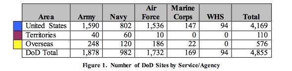
Of course, the US military is also omnipresent in the United States, with installations in all 50 states and seven territories.  The Base Structure Report includes this summary:

DoD sites JPEG

And these bases have brought their own problems and spawned their own protests too.


‘Imagination bodies forth…’

Following from my previous post, I’ve been thinking a lot about bodies recently, and for two reasons.

DUDZIAK War-timeThe first is the workshop on War & Medicine I attended in Paris just before Christmas.  It became very clear early on how difficult it is to determine when military violence comes to an end; Mary Dudziak has recently written about this in her War time: an idea, its history, its consequences (Oxford, 2012), largely from a legal point of view (and not without criticism), but it’s worth emphasising that the effects of violence continue long after any formal end to combat.  This ought to be obvious, but it’s astonishing how often it’s ignored or glossed over.

Think, for example, of the continuing toll of the conflicts in Afghanistan and Iraq, recovered in detail by Catherine Lutz (who was part of the workshop) and her colleagues at the Costs of War project, which shows how ‘the human and economic costs of these wars will continue for decades’.

NIXON Slow violenceOr think of  the toxic environments produced by ecological warfare, by the use of depleted uranium in munitions, and by the continued deployment of land mines and cluster bombs – what Rob Nixon brilliantly calls the ‘slow violence’ produced by ‘ecologies of the aftermath’ (more on this in a later post):

 ‘In our age of depleted-uranium warfare, we have an ethical obligation to challenge the military body counts that consistently underestimate (in advance and in retrospect) the true toll of waging high-tech wars.  Who is counting the staggered deaths that civilians and soldiers suffer from depleted uranium ingested or blown across the desert?  Who is counting the belated fatalities from unexploded cluster bombs that lie in wait for months of years, metastasizing into landmines?  Who is counting deaths from chemical residues left behind by so-called pinpoint bombing, residues that turn into foreign insurgents, infiltrating native rivers and poisoning the food chains?  Who is counting the victims of genetic deterioration – the stillborn, malformed infants conceived by parents whose DNA has been scrambled by war’s toxins?’

(If you think we are winning the war on land-mines, especially in you are in Canada, read this).

These two contributions – and the conversations we had in Paris – rapidly displaced the lazy assumption of a politics of care in which the left mourns civilian casualties and the right military casualties. That there is a politics of care is clear enough, but there’s also a political geography: that’s written in to the biopolitical projects that are contained within so many late modern wars, and in Paris Omar Dewachi and Ghassan Abu-Sitta described how ‘care’ has become a means of controlling populations in wars in Iraq, Libya and Syria – a rather different sense of ‘surgical warfare’ from the one we’re used to – with states like Saudi Arabia and Qatar also funding the transfer of thousands of injured people from the war zones for treatment in hospitals in Egypt, Jordan and Lebanon.

And two brilliant medical anthropologists, Ken Macleish and Zoe Wool, brought with them vivid, carefully wrought ethnographies of injured soldiers’ bodies.  The American soldier may appear a figure of unprecedented invulnerabilty and astonishing violence – what Ken calls a figure of ‘technological magic’ produced by a ‘phantasmagoric technological empowerment of the body’ – but, as he and Zoe reminded us, soldiers are not only ‘the agents and instruments of sovereign violence’ but also its objects.  Their studies took me to places I’ve never been and rarely thought about, but I’ve been thinking about two other dimensions of their work that combined to produce my second reason for thinking about bodies.

One is the historicity that is embedded in this process.  Ken paraphrased Walter Benjamin‘s observation in the wake of the First World War – ‘the technological progress evident in modern warfare does not ensure the protection of the human body so much as it subjects it to previously unimaginable forms of harm and exposure’ – and linked it to John Keegan‘s claim in The face of battle that the military history of the twentieth-century was distinguished by the rise of ‘”thing-killing’ as opposed to man-killing weapons’ (the example he had in mind was heavy artillery).  The other is the corporeality of the combat zone.  Ken again:  ‘You need not only knowledge of what the weapons and armor can do for you and to you but a kind of bodily habitus as well – an ability to take in the sensory indications of danger and act on them without having to think too hard about it first.’  In an essay ‘On movement’ forthcoming in Ethnos, Zoe develops this insight through an artful distinction between carnality and corporeality (which may require me to revise my vocabulary):

‘The analytics of movement is a turning toward emergent carnality, flesh, and the way it is seen and felt; proprioception and those other senses of sight, sound, touch, and taste through which a body and a space enact a meaningful, sensible articulation; visceral experiences forged and diagnosed through the trauma of war which also exceed its limits.’ 

an-ice-cream-warAnd so to my second reason for thinking about bodies. Later this month I’m giving a lecture in the University of Kentucky’s annual Social Theory series.  The theme this year is Mapping, and my title is ‘Gabriel’s Map‘.  This is a riff on a phase from William Boyd‘s novel, An Ice-Cream War, that has haunted me ever since I first read it:

‘Gabriel thought maps should be banned.  They gave the world an order and reasonableness it didn’t possess.’

The occasion for the remark is a spectacularly unsuccessful British attempt to defeat a much smaller German force in November 1914 at Tanga in German East Africa; the young subaltern, Gabriel, rapidly discovers that there is a world of difference between what Clausewitz once called ‘paper war’ – a plan of attack plotted on the neat, stable lines of a map – and ‘real war’.   What I plan (sic) to do is arc back from this exceptionally brutal campaign – which lasted two weeks longer than the war in Europe – to the western front.  The two were strikingly different: the war in Africa was a war of movement and manoeuvre fought with the most meagre of military intelligence, whereas the central years of the war in Europe were distinguished by stasis and attrition and involved an extraordinary effort to maintain near real-time mapping of the disposition of forces.

The point here is to explore a dialectic between cartography and what I think I’m going to call corpography.

FINNEGAN Shooting The FrontThe first of these has involved working out the intimate relationship between mapping and aerial reconnaissance (what the Royal Flying Corps called ‘shooting the front’).  There is a marvellously rich story to be told here which, among other things, shows that the stasis of trench warfare was Janus-faced: it was produced by a myriad of micro-movements – advances and withdrawals, raids and repulses – whose effectiveness depended not on the fixity of the map at all but on its more or less constant updating (which in turn means that this capacity isn’t the unique preserve of twenty-first century ‘digital navigation’).  So here I’ll show how a casaced of millions of trench maps and aerial photographs was produced, distributed and then incorporated into the field of action through copies, re-drawings, sketches and annotations by front-line soldiers.  I have wonderful, telling examples, like this one (look carefully at the annotations):

Trench map annotated

Santanu DAS: Touch an dintimacy in First World War literatureBut I also want to show (as the map above implies: all those “full of dead” annotations) how, for these men, the battlefield was also literally a field: a vile, violent medium to be known not only (or even primarily) through sight but through touch, smell and sound: what Santanu Das memorably calls a ‘slimescape’ which was also a soundscape.  This was a close-in terrain that was known through the physicality of the body as a sensuous, haptic geography:

‘Amidst the dark, muddy, subterranean world of the trenches, the soldiers navigated space … not through the safe distance of the gaze but rather through the clumsy immediacy of their bodies: “crawl” is a recurring verb in trench narratives, showing the shift from the visual to the tactile.’

This was a ‘mapping’ of sorts – as Becca Weir suggests in  ‘“Degrees in nothingness”: battlefield topography in the First World War’, Critical Quarterly 49 (4) (2007) 40-55 – and there is a dialectic between cartography and corpography.

I’ve been working my way through a series of diaries, memoirs and letters to flesh out its performance in detail, but the most vivid illustration of the entanglements of cartography and corpography that I’ve found – and that I suspect I shall ever find – is this extract from a ‘body density map’ for part of the Somme.  This shows the standard trench map above a contemporary satellite photograph; each carefully ruled square is overprinted with the number of dead soldiers found buried in the first sweep after the war (between March and April 1919)…

Body Density Map, High Wood, Somme image by shipscompass on flickr

I won’t say more at present because I need to keep my powder dry for Kentucky, but I hope it will be clear by the end that, even though I’ll be  talking about the First World War, I will also have been talking about the wars conducted in the shadows of the Twin Towers and the Pentagon.