The Leaden Hours

Ever since I attended a conference at Nijmegen on Transmobilities I’ve followed the current interest in ‘mobilities’, though from a distance and perhaps in strange ways: but I think that the following study contributes to that debate as well as to quite different preoccupations with the intersections of military geography, medical geography and my current research on woundscapes and ‘trauma geographies‘. Let me know what you think.

Modern trauma response pays close attention to what happens in the ‘platinum ten minutes‘ immediately after injury and treats the ‘golden hour‘ to definitive medical treatment as the standard to which casualty evacuation should adhere.  I explored the implications of these metrics for treatment outcomes and survival rates in Afghanistan in ‘the geographies of sixty minutes‘, and as part of my comparative work I’ve been examining the speed of casualty evacuation on the Western Front in the First World War.

The politics of speed

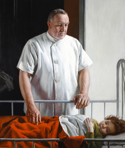
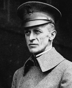
This turns out to be a complicated issue, and one that attracted considerable controversy – both professional and political – throughout the war.  There are summaries in Ian Whitehead‘s Doctors in the Great War and in Ana Carden-Coyne‘s The politics of wounds, but some of the sharpest exchanges (in early January 1917) were sparked by a memorandum from Sir Almroth Wright, Consultant Physician to the British Expeditionary Force, criticising what he saw as the preoccupation with rapid evacuation at all costs.  His charges were summarily dismissed by General Sir Arthur Sloggett, (right, shown in 1917), the Director-General of Medical Services for the British Expeditionary Force – in angry memoranda and meetings and in acerbic private correspondence – as being entirely without foundation and, indeed, ‘ignorant’ and even ‘stupid’ (see RAMC 365/4 here).

Some front-line medical officers were more perturbed than these exchanges suggest.  Surgeon Henry Kaye, for example, addressed the issue in his diary for 24 January 1916, when he sought an explanation for the mortality rates from ‘different classes of wounds’ passing through his casualty clearing station:

‘I should surmise that the only controllable factor is that of transport – ie that a certain percentage of the mortality is due to the transport of seriously wounded men – people are so pleased with the excellence of the transport arrangements (ambulances, trains, and ships) that they forget what a great additional strain any transport imposes on the patients, and are apt to lay approving stress on how quickly they have transported thousands of cases to England, without regarding (or at least mentioning) how many men this express transport has cost their lives. (Diary, Wellcome Institute, RAMC 739/4)

Notice that word ‘surmise’.  Given the joined politics of speed it is surprising that there should have been so few detailed studies at the time.  In their survey of ‘The development of British surgery at the Front’, published in the British Medical Journal on 2 June 1917, Surgeon-General Sir Anthony Bowlby and Colonel Cuthbert Wallace (Consulting Surgeon to the British Army) showed that out of 200 abdominal cases received at one casualty clearing station (CCS), 164 arrived within 12 hours, another 35 arrived in the next 12 hours, and 31 took over 24 hours to reach the CCS (p. 706).  

Another surgeon concluded from these figures that one third of the casualties ‘arrived so late that they had little chance of recovery because of the elapsed time alone’ (Daniel Fiske Jones, ‘The role of the evacuation hospital in the care of the wounded’, Annals of Surgery 68 (2) (1918) 127-132: 130).  In a second tabulation Bowlby and Wallace drew on a different sample of abdominal cases which confirmed that 51 per cent of those who arrived at a CCS within 12 hours survived (at least long enough to be transferred to a base hospital on the coast), but for those who took longer than 12 hours the survival rate fell to 33 per cent (p 716).

If nothing else, these figures confirmed the importance of evacuation rates, but their wide dispersion raised a series of important questions. The Australian Army provided two later studies that attended more closely to the geographies of casualty evacuation – and, to some degree, addressed the dispersion in the figures from Bowlby and Wallace – and for the rest of this post I’ll focus on the most detailed of the two.

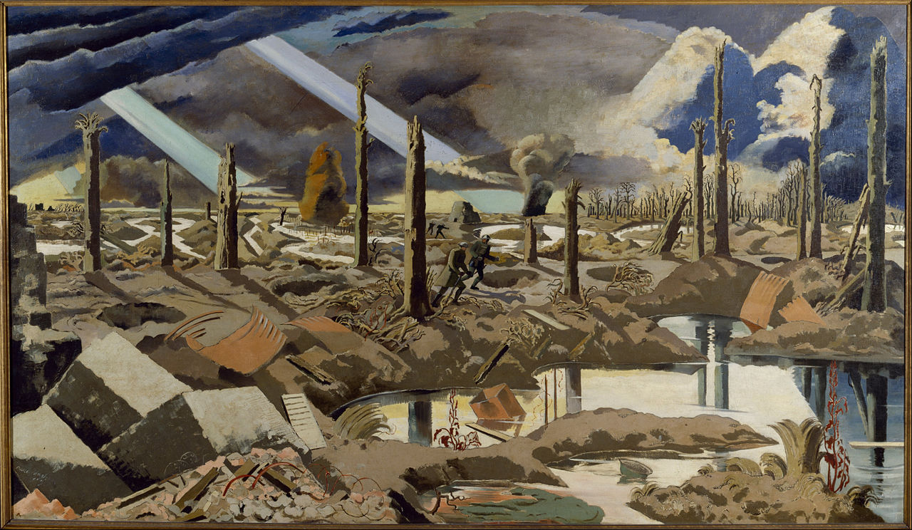
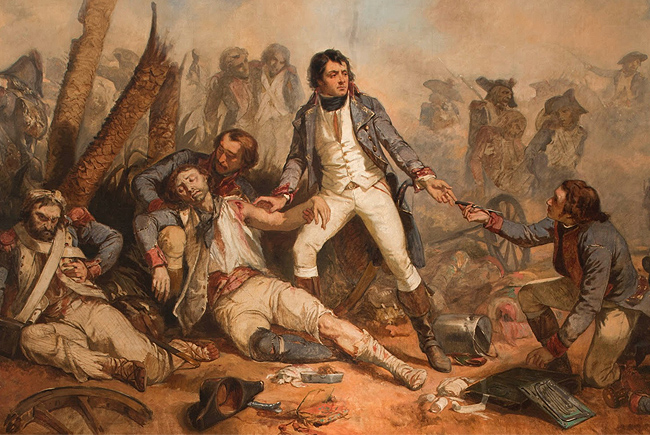
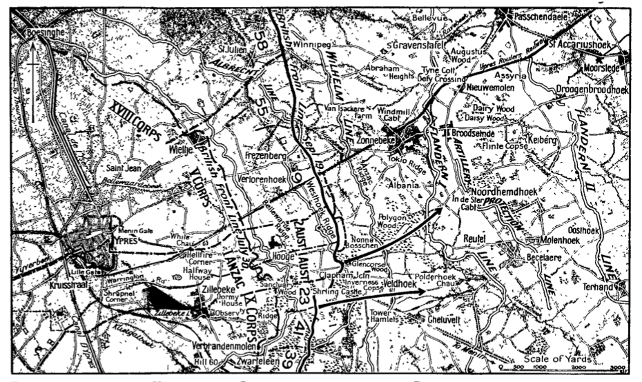
This related to the evacuation scheme in operation for what became known as the Battle of Menin Road (20-25 September 1917). The image above is Paul Nash‘s celebrated rendering of The Menin Road, which he completed in February 1919.  Nash served on the Ypres Salient from February 1917 as a second lieutenant, but a few months later he missed his footing in the dark, fell into a trench and broke a rib.  He was evacuated to England, and returned to the Salient in November as an official war artist. (There is a fine discussion of Nash’s art and its relation to the war in Paul Gough‘s A Terrible beauty: British artists in the First World War; for The Menin Road in particular, see pp. 150-62 ).

Third Ypres: the first two phases

The Battle of Menin Road was the third phase of ‘the Third Battle of Ypres’ (July-November 1917) that culminated in the fall of Passchendaele (the name by which the whole series of offensives is often known).  The object of the campaign was to seize control of the line of low hills – ‘the ridge’ – running south and east of Ypres.

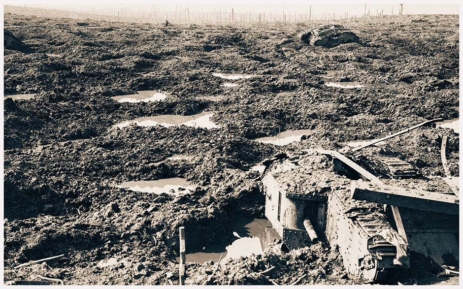
The first two phases were directed against Pilckem Ridge (31 July to 2 August) and Langemarck (16 to 18 August).

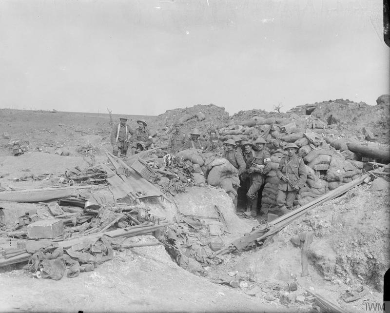
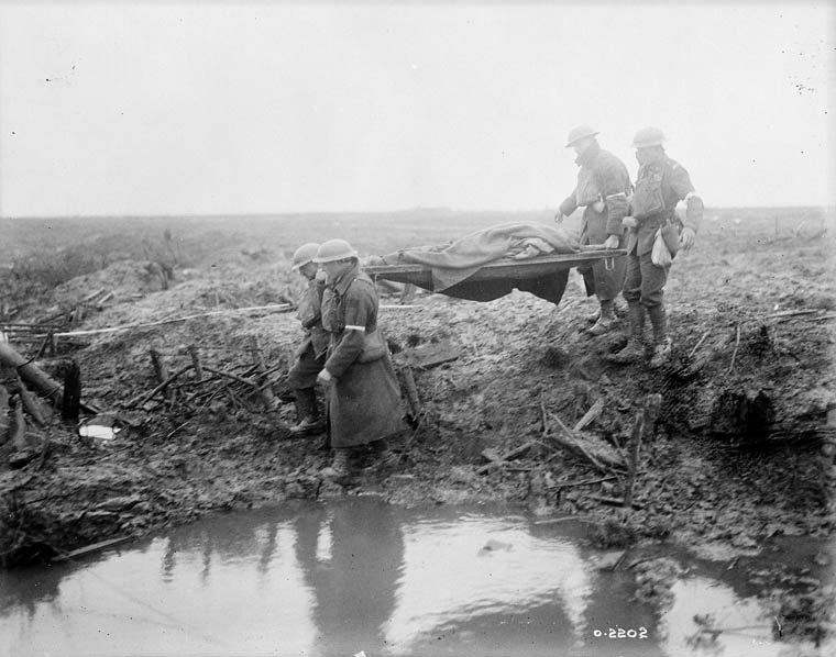
For the medical services there were two pressing problems.  The first was the retrieval of casualties by relays of stretcher bearers.  The terrain had been reclaimed from marshland by an elaborate system of drains but these were destroyed by savage and relentless artillery bombardments, and  Colonel A.G. Butler explained that ‘with the rains – expected in the autumn – the low, flat countryside reverted to primitive morass’ (Official History of the Australian Army Medical Services in the War of 1914-1918, Vol. II: The Western Front, p. 184n).  Confounding the Allies’ expectations, however, the rains broke at the end of July.  The conditions were frightful, the casualties horrendous, and on 1 August Lt John Warwick Brooke took what turned out to be an iconic photograph that caught the intersection of the two: no fewer than seven bearers struggling to carry a stretcher through the thick, plastering mud-slime near Boesinghe:

That same day Private Walter Williamson was ordered to a ruined building – he had no idea what it used to be – where his Regimental Medical Officer had established an aid post:

The place had simply been battered with shell fire and the road ploughed up, but this had now settled down to one horrible level surface of water and oozing mud….

Stretchers with their pitiful burdens were brought out from the inner recesses of the ruins, and we were detailed each four to a stretcher … containing a badly wounded lad who was only conscious enough to feebly moan to us to put him straight in the boat [to ‘Blighty’]. We heaved the stretcher to our shoulders, and started off that long remembered journey down the St Julien road. In addition to being weak and tired, our uneven heights made carrying difficult, and it must have been torture for the poor occupant of the stretcher. In the best places, the road was nearly knee deep in mud, and shell holes could not be located except by testing each foothold. Planks had been put down in places where the whole width of the road had been blown up, but these were now floating aimlessly about, and any attempt to use them would have resulted in a spill, and hurling our burden into the mud. Rain still poured down unceasingly and the road was being shelled viciously. We could not well duck at the shells, with a badly wounded man dependent on steady shoulders, and all we could do was to plod through and trust to good luck…

The road was a gruesome nightmare, bodies lay in the mud all along the road and burial parties were busy collecting them as best they could. Dead mules, horses, wrecked guns, limbers and all the terrible debris of battle lay in the mud. We were getting now, that we could not carry the stretcher more than a hundred yards at a stretch, and each time we rested, we found it more difficult to heave it up again, but we plodded along with red hot shoulders and cracking backs, sometimes having to get nearly waist deep to find a foothold across some huge hole that stretched from one side of the road to the other’ (Doreen Priddey (ed), A Tommy at Ypres: Walter’s War).

They eventually succeeded in delivering the poor man to a motor ambulance, which would have taken him to a dressing station or a casualty clearing station.  

The walking wounded didn’t fare much better, and the distinction between them and stretcher cases was by no means clear-cut or constant, as the experience of Private Alfred Warsop makes horribly clear.  Hit by shrapnel in the jaw, arm and chest, he passed out and when he came round ‘a doctor was just finishing bandaging me up and he said, “Get a stretcher for this man as soon as you can.”‘  Realising there were unlikely to be enough bearers available to carry him through the mud, he decided to walk out:

‘I persuaded a first aid man to put his hand in the middle of my back and hoist me on my feet. I tottered out determined to get down to the Menin Road or die in the attempt –on this occasion no idle phrase. It was all slippery mud, shell holes and trenches. I soon found that I had lost nearly all sense of balance with both arms useless. No doubt I was able to make that journey because I was suffering from shock and not feeling things as you normally would’ (in Steel and Hart, Passchendaele: the sacrificial ground)

Similarly, Gunner Walter Legg recalled coming to the aid of a badly wounded young soldier – carrying him to a shell hole and applying a field dressing, then helping him stumble to the aid post:

‘I remember vividly that with each step he took, blood oozed out on to the loose loop of his braces and fell drop by drop on his trousers.  From where we were I could see the forward dressing station about a quarter of a mile to the rear…  We managed to make progress a few yards at a time.  We’d shelter for a bit in a shell-hole, and then if the shelling seemed to be easing up we’d crawl into the next one and wait there for a bit, then try and get to the next one a yard or two away.  After a couple of hours … we’d only gone thirty or forty yards…

It took us ten hours to cover that quarter-mile to the dressing station, and when we got there we were absolutely drenched to the skin and thick with mud’ (in Lynn MacDonald, They called it Passchendaele).

The second problem emerged as soon as the injured reached a road: their transfer to a main dressing station or casualty clearing station was often slowed because the roads were in a poor condition, many of them full of craters and badly degraded by the constant traffic of convoys and marching columns, but also because the ambulances had to struggle against the flow, yielding to fresh troops, ammunition and supplies moving in the opposite direction.  The priority was clear. ‘The conditions of warfare demand … that wounded men shall be got out of the war,’ wrote one senior medical officer, so that supplies of reinforcements, ammunition and food to the fighting line are not interfered with’ (Col. H. M. W. Gray, ‘Surgical treatment of wounded men at advanced units’, New York Medical Journal 107 (1917)).

To regulate the flow, elaborate arrangements were made to control the direction of traffic, sometimes with special routes designated for ambulances.  The map below shows the traffic circuits established by the Fifth Army around Ypres by 27 July 1917:

[Roads shown in red could be used in both directions; roads shown in blue only in the direction indicated; roads not coloured were not to be used by lorries and could be used by ambulances or light traffic; there was ‘no restriction placed on Motor Cars containing Officers on duty’.]

Despite the slow journeys faced by wounded soldiers, the casualty clearing stations were hard pressed to keep up with the tide of injured bodies.  This was particularly true for those fed by by broad-gauge train from dressing stations in Vlamertinghe and Ypres.  That was how most of the nominally ‘walking wounded’ arrived at the CCSs at Remy Siding on the night of 31 July/1 August.  ‘They consequently arrived in very large batches,’ Major-General Sir W.G. Macpherson explained, ‘instead of coming down in small numbers at a time by lorries and charabancs.’  This overwhelmed the CCSs and delayed the departure of ambulance trains to the base hospitals, which could not leave until the casualties had been cleared, and the congestion was compounded because the trains bringing them in used the same siding as the ambulance trains waiting to come up and load: eight of them were scheduled in the first 24 hours (Medical Services, General History, Vol. III, pp. 160-1).

On that first day US surgeon George Crile, working at No 17 British CCS at Remy Siding, described how

‘The stream of wounded began to increase in volume, slowly at first, then rapidly, until the entire Remy Siding was swamped.  By the night of August first, every bed, every aisle, every tent, every inch of floor space was occupied by stretchers – then the rows of stretchers spread out over the lawn, around the huts, flowing out towards the railway…

The operating rooms ran day and night without ceasing.  Teams worked steadily for twelve hours on, then twelve hours off, relieving each other like night–day–night shifts.  There passed through the Remy Siding group of [three] CCSs over ten thousand wounded in the first forty-eight hours.  I had two hundred deaths in one night in my service.  The seriously wounded piled up so fast that nothing could be done with them, so I told the sister to administer as near an overdose of morphine as was possible to keep them alive but free of suffering’ (Autobiography, pp. 301-2).

It was the same everywhere.  Here is another American surgeon, Harvey Cushing, writing in his journal at No 46 British CCS near Proven at 0230 the next morning:

Pouring cats and dogs all day – also pouring cold and shivering wounded, covered with mud and blood…. The pre-operation room is still crowded – one can’t possibly keep up with them; and the un-systematic way things are run drives one frantic. The news, too, is very bad. The greatest battle of history is floundering up to its middle in a morass, and the guns have sunk even deeper than that. Gott mit uns was certainly true for the enemy this time.

Operating from 8.30 a.m. one day till 2.00 a.m. the next; standing in a pair of rubber boots, and periodically full of tea as a stimulant, is not healthy. It’s an awful business, probably the worst possible training in surgery for a young man, and ruinous for the carefully acquired technique of an oldster. Something over 2000 wounded have passed, so far, through this one C.C.S. There are fifteen similar stations behind the battle front (From a surgeon’s journal, p. 175).

(In his biography of Cushing, Michael Bliss remarked that having such a great surgeon perform brain surgery at a CCS – with exquisite care and meticulous attention to detail – was ‘like a master chef working at McDonald’s’, but Crile told Bowlby he was a model technician and advised him to organise the other surgical teams to handle the overflow).

The combined toll of these two phases in July and August was sobering, but they advanced the line to the east of Hooge (or, more accurately, to what was left of it: ‘even the road was untraceable,’ Charles Bean explains, ‘and the village site was only marked by a cluster of mine craters’ (Official History of Australia in the War of 1914-18, Vol. IV: The A.I.F. in France [sic]: 1917).  With that, the offensive appeared to have ground to a halt – literally so – and the German High Command concluded that Third Ypres was over.

The third phase: Menin Road

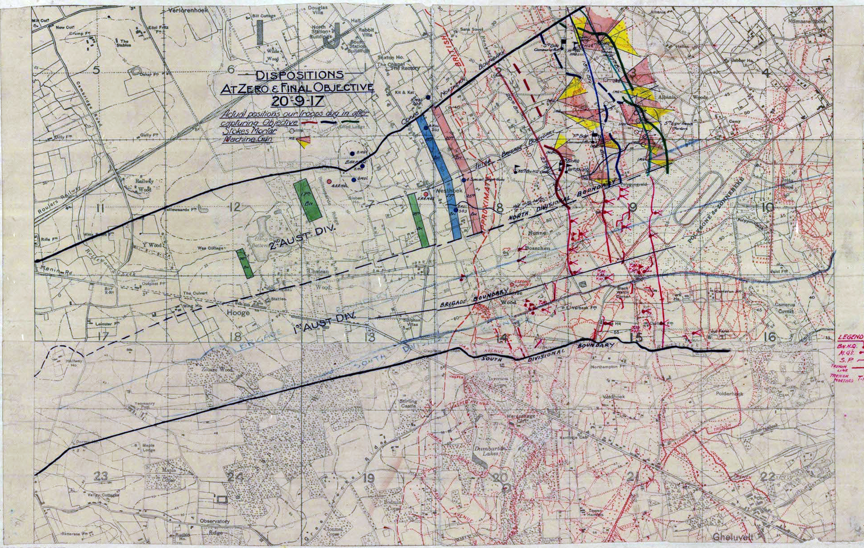
They were mistaken.  On 25 August British field command had been transferred to Lt General Herbert Plumer who devised a new, more measured plan for the third phase, which involved four short steps across a narrow front, separated by breaks to bring up the guns and supplies.  It would be spearheaded by Australian and New Zealand troops, with British and South African support.

Plumer took the next three weeks to prepare the ground for the first of his graduated steps, which was the Battle of Menin Road.  The road had been what one NCO called ‘the artery of the battlefield’ during the limited advance of the summer (Corporal J. Pincombe, in Lynn MacDonald, They called it Passchendaele, p. 144), and it remained a live fire zone.  ‘They had to keep the Menin Road open,’ recalled one driver with the Royal Artillery,

‘because it was the only way you could get up to that sector with horses and limbers, and it was shelled day and night.  The Germans had their guns registered on it to a T, and the engineers had to keep filling up the shell-holes … and keep the traffic going’ (Driver J. McPherson, in Lynn MacDonald, They called it Passchendaele, p. 177)

Paul Ham describes the scale of the preparations:

Plumer packed every ounce of energy and action into those few weeks. Within the next seventeen days, 156 trainloads carrying 54,572 tons of matériel arrived at the railheads, all of which had to be trucked, entrained, dragged or carried on mule-back to the front.  Light tramways were hastily reconstructed and roads rebuilt out of wooden planks. Shell holes were filled in and stamped down; gun emplacements firmly laid; telephone lines unrolled and buried; rations and medical supplies prepared and brought forward –all of which proceeded within range of German shellfire. Miles of duckboards were laid, latticing the drying plain, connecting little islands and ridges of high ground in the hardening mud. The men trained all day, rehearsing new platoon tactics, pillbox flanking manoeuvres and how to coordinate their advance with the creeping barrage, worked out to mathematical certainty (Ham, Passchendaele, p. 245).

In the interval the ground dried out and the terrain ‘changed from a morass into a desert’ (Bean, AIF, p. 748).  But it was still immensely difficult terrain, riddled with shell holes and all the hideous detritus of war.  In a letter written from Vlamertinghe on 17 September Hugh Quigley painted a bleak picture:

‘The country resembles a sewage-heap more than anything else, pitted with shell holes of every conceivable size, and filled to the brim with green, slimy water, above which a blackened arm or leg might project.  It becomes a matter of great skill picking a way across such a network of death traps, for drowning is almost certain in one of them (in Martin Marix Evans,  Passchendaele: the hollow victory).

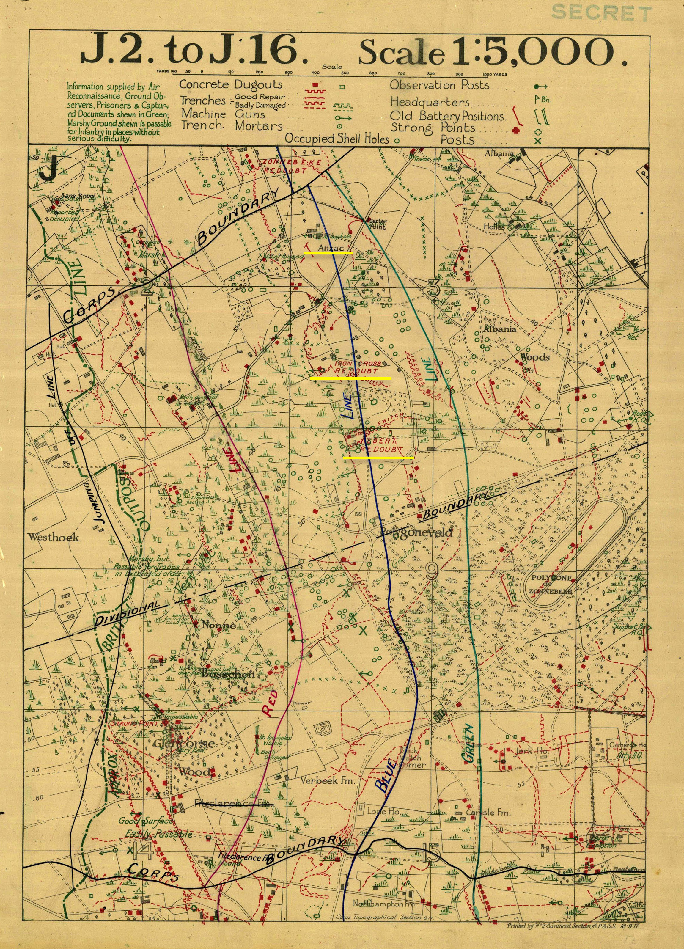
The next map shows the line two days later, on 19 September – the night before the new offensive began:

Plumer’s plan called for clockwork precision.  The infantry were to advance behind a devastating rolling barrage, whose opening curtain would fall just 150 yards (130 metres) in front of the troops; after three minutes, as the troops moved up, it would roll forward at 100 yards every four minutes for the first 200 yards, and then at a rate of 100 yards every six minutes until the first objective, the Red Line, was reached: a distance of 750 metres.  The barrage would then halt for 45 minutes before rolling on at 100 yards every eight minutes until the Blue Line was reached: a further 400 metres.  After a pause for two hours the barrage would advance again at the same rate to the Green Line, the last objective of the day: a further 200 metres.

The slow rate of advance – compared to other rolling barrages – and the short distances eased the difficulty of picking passages through the pock-marked terrain, but there was little room for error or misstep.  Observing a rehearsal, Captain A.M. McGrigor recorded that

‘it did bring home to one how appallingly mechanical everything is now, and how every man must conform to the advance of the barrage.  Initiative and dash must to a certain extent be fettered as every forward movement is worked out so carefully and mathematically’ (in Robin Prior and Trevor Wilson, Passchendaele: the untold story)

Planning for casualties

These precise timings were complemented by similar calculations in the accompanying plan for medical provision drawn up by General Arthur Sloggett, perhaps still smarting from and certainly still contemptuous of Wright’s criticisms (above), and Surgeon-General G.B.M. Skinner (Fifth Army), which was intended to remove the extraordinary frictions that had bedevilled the evacuation chain during the summer.  Butler makes the parallel explicit: ‘The machinery for clearing our own casualties had to move with the same clockwork precision as that designed by us to create them in the enemy’ (Australian Army Medical Services, p. 211).

Their plan was guided by two imperatives.

(1)  Casualty Clearing Stations  The first was to bring casualty clearing stations as close to the line as possible.  This entailed a continuation of the system that had emerged during the summer.

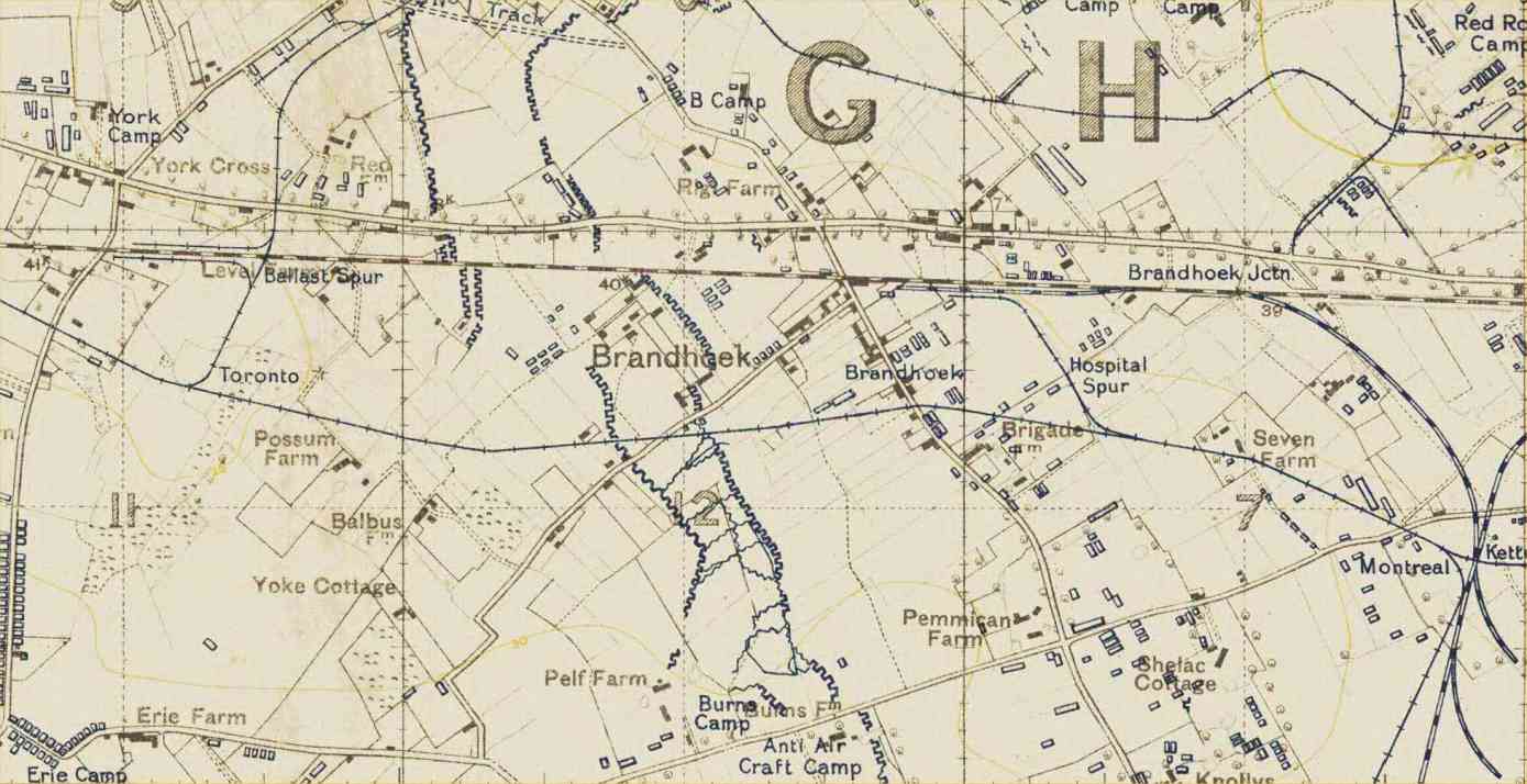
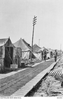
In July and August three CCSs had been deployed just five miles from the front at a railway siding at Brandhoek, located just off the main Ypres-Poperinghe road, and offering direct rail access for hospital trains to the base hospitals at Boulogne and Calais.

Sister Kate Luard was thrilled with the experiment, writing in her diary that ‘we … shall be near enough to the line to get them from the dressing stations direct, without long journey and waits which is what the C.C.S.’s are out to prevent nowadays.’  She arrived at Brandhoek on 27 July, and while she was delighted at what she found (not least because she would be working at a specialist CCS for the treatment of abdominal wounds) she again emphasised the experimental nature of the location:

The hospital had only been pitched since last Saturday and it was already splendid. This venture so close to the Line is of the nature of an experiment in life-saving, to reduce the mortality rate from abdominal and chest wounds. Their chance of life depends (except where the injuries are such as to be beyond any hope of recovery) mainly on the length of time between the injury and the operation. As modern Field Surgery can now be carried out under conditions of perfect asepsis, the sooner the infection always introduced into every wound with the missile is dealt with, and the internal repairs carried out, the more chance the soldier has of life. Hence this Advanced Abdominal Centre, to which all abdominal and chest wounds are taken from a large attacking area, instead of going on with the rest to the C.C.S.’ s six miles back….

Sir Anthony Bowlby turned up later. ‘How d’you like the site this time? Front pew, what? front row dress-circle.’ It is his pet scheme getting the operations done up here within an hour or two of getting hit, instead of farther back or at the Base. That is why our 30 Medical Officers include the largest collection of F.R.C.S.’ s [Fellows of the Royal College of Surgeons] ever collected at any Hospital in France before, at Base or Front, twelve operating Surgeons with Theatre Teams working on eight tables continuously for the 24 hours, with 16 hours on and 8 off.

The location was ideal for rapid medical treatment; but as was often the case, the railway line also made it an optimal location for artillery batteries and ammunition dumps.  When Harvey Cushing visited Brandhoek two days later he observed that ‘the three CCSs were ‘necessarily alongside both road and railway, for hospitals and ammunition dumps must compete for sites of the same kind – and hence they are likely to be heavily shelled.’  And as Colonel A.G. Butler confirmed in the official history of the Australian Army’s medical services, ‘the site had the grave disadvantage that some British 15-inch guns were near by, and huge supply and ammunition dumps covered the adjoining area’ – all, as he concedes, ‘legitimate and obvious targets for German artillery’ (Australian Army Medical Services, p. 188).

It was quiet when Bowlby and Cushing visited, but the medical staff did not have long to wait before their fears were confirmed.  On 30 July Luard wrote:

‘Soon after 10 o’clock this morning [the Germans] began putting over high explosive. Everyone had to put on tin-hats and carry on. He kept it up all the morning with vicious screams. They burst on two sides of us, not 50 yards away – no direct hits on to us but streams of shrapnel, which were quite hot when you picked them up. No one was hurt, which was lucky, and they came everywhere, even through our Canvas Huts in our quarters. Luckily we were so frantically busy that it was easier to pay less attention to it. The patients who were well enough to realise that they were not still on the field called it ‘a dirty trick.’ 

It is doubtful that the CCSs were the intended target (and they were treating many German prisoners).  Rather, as Sister May Tilton recorded, the area was ‘a huge city of canvas, batteries and ammunition dumps’ – the question of co-location constantly dogged casualty clearing stations and base hospitals alike (see here) – and throughout the next month Brandhoek was subjected to regular shelling and air raids.

On 2 August Luard wrote that ‘it made one realise how far up we are to have streams of shells crossing over our heads’ – from the German lines and from the British batteries around Brandhoek – but the danger was also a more proximate one.  Here she is a few days later:

There is a cheery little Military Decauville Railway for ammunition only, running immediately between our Compound and the main Duck Walk cutting our Hospital in two, and you are always having to wait to cross the rails while a series of baby trains puff through loaded to the teeth with shells, or coming back with empty cases.

The attacks intensified, and on 14 August Tilton wrote that last night

‘No one slept, day or night staff. Our bell tents were dugouts. They had lowered us considerably and sandbagged the outsides so heavily, we felt quite comfortable. It needed a direct hit to get us…’

At 10.30 pm ‘the Gothas [bombers] were over’ and ‘shells were bursting quite close’, but the British batteries responded with alacrity: “Big Bob” [the 15-inch guns] set our tents rocking and vibrating with his fierce and mighty roar.’

On 18 August Luard was outraged at German attacks on hospitals – but she was specifically referring to those in the rear:

He [‘Fritz’] played about all night till daylight. There were several of him. He went to C.C.S.’ s behind us. At one he wounded three Sisters and blew their cook-boy to pieces. The Sisters went to the Base by Ambulance Train this morning. At the other he wounded six Medical Officers among other casualties. A dirty trick, because he has maps and knows which are hospitals back there. Here we are in a continuous line of camps, batteries, dumps, etc., and he may not know.

That last sentence was crucial, but the CCSs at Brandhoek were subjected to sustained shelling throughout the day on 21 August, and two days later Sister Elsie Grant wrote to her sister from Brandhoek with no hesitation in assigning blame:

‘We have been shelled out three times but this last time was too dreadful. Those brutal Germans deliberately shell our hospital with all our poor helpless boys but really God was good to us we had four killed but it was just miraculous that there were not dozens killed. Of course we (the sisters) were put into dugouts as soon as the shelling got bad but I can’t tell you how cruel it was to leave those poor helpless patients. In a few hours the whole hospital was evacuated & one consolation we saw our last patient carried out before we were sent away.’

Two of the CCSs were immediately moved back to ‘Nine Elms‘ (below), five miles behind Poperinghe, while Luard’s remained to provide treatment for walking wounded until it too was evacuated in early September.

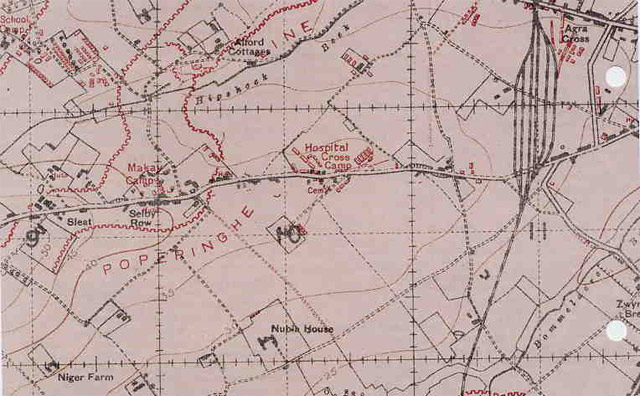
Throughout these attacks and dispersals, the CCSs had continued to work at full capacity to deal with the thousands of casualties.  But by September the closest CCSs for the Battle of Menin Road were now all much further back: at Nine Elms, at Remy Siding, and three other groups near Proven known in the British Army’s ironic Flemglish as ‘Mendinghem’, ‘Dozinghem’ and ‘Bandaghem’.  Cushing explained:

The place…  is called “Mendinghem.” This was originally a joke and was to have been “Endinghem”; but this on second thought was changed as being too much even for the Tommy. The army has a professional name maker, I may add. Mendinghem is already on the printed maps and there is in this district a “Bandagehem” and “Dosinghem” which I have not located as yet.

They are all all shown on this map:

These relocations did not end the raids, and the official British medical history by Major-General W.G. Macpherson includes a detailed list of enemy shelling and bombing of CCSs from 3 July to 29 October (pp. 163-4); Mendinghem and Dozinghem were repeatedly attacked. According to Cushing, the staff at Dozinghem were particular upset ‘because General Skinner had ordered an electric Red Cross to be shown at night – a good mark to shoot at’ (A surgeon’s journal, p. 193).  In fact, Macpherson concluded that these attacks

‘were of so exceptional a character as to give rise to the belief that they were deliberate.  The medical units were indicated by the usual red cross signs on roofs of huts, and also on large squares on the ground such as could be seen by aircraft.  The positions of casualty clearing stations had also been notified to the enemy’ (Medical Services, General History, Vol. III, p. 162).

Macpherson, wise after the event, commented that Brandhoek ‘had always been regarded as too far forward’ – he claimed the CCSs were only there at the insistence of the Fifth Army commander and his Director of Medical Services – and concluded that the whole affair showed ‘that a journey of twenty minutes to half-an-hour to a more secure locality farther back is not likely to be so great a risk to the patient as his retention in a more forward position which is in danger of being shelled by the enemy’ (p. 156).

(2)  Direct evacuation  The retreat of the forward CCSs placed a still greater premium on the second imperative, which involved another experiment, a concerted attempt to expedite the movement of the wounded to the rear.  In practice, this resolved into marking and co-ordinating evacuation routes for bearer teams and ambulances, minimising treatment at all intermediate dressing stations (even the administration of anti-tetanus serum had to wait until a casualty arrived at the CCS), and separating casualty streams from the Advanced Dressing Stations (ADS) into the three circuits shown on the diagram below:

I’ve seen many similar maps – the war diaries of Field Ambulances are full of them, either superimposed over or based on trench maps, and Regimental Medical Officers were accustomed to draw up their own annotated sketch maps showing the location of aid posts and the routes to be followed by the regimental stretcher bearers – but this one is unusual because it extends beyond the immediate recovery zone and (following directly from the emphasis on direct evacuation) includes a series of timings from the front line all the way back to the CCSs at Remy Siding.

As the map shows, ‘walking wounded’ made their own way to the collecting point at Hooge on the Menin Road and then (by ambulance or light rail if space were available, otherwise on foot) to the ADS designated for them in Ypres.

The more seriously wounded were brought to the same collecting point by regimental stretcher bearers in a series of relays; this was estimated to take between 10 and 40 minutes during the day and around 60 minutes at night.  The casualties were then transferred by motor ambulance to the ADS for stretcher cases, just across the road from the ADS for walking wounded (below).

The location of the two ADSs made sound logistical sense, but they were uncomfortably close to heavy artillery batteries and naval guns and were repeatedly shelled.  Together the ADSs acted as the hub for what the Medical History calls the ‘elaborately detailed’ system of onward evacuation (Australian Army Medical Services, p. 202):

  • Those who could withstand the journey – a further 80-120 minutes, according to the map – followed Circuit A (‘long distance’) to the CCSs at Remy Siding; 58 per cent of stretcher cases followed this route.
  • Those suffering from shock, gas or haemorrhage followed Circuit B (‘short distance’) to the Main Dressing Station at Dickebusch, a journey of 20-30 minutes; 27 per cent of stretcher cases followed this route.
  • Those who needed immediate surgery were sent direct to Remy on Circuit C  – a journey of 90 minutes – and 15 per cent followed this route.

It’s not clear how these timings were established: they were almost certainly estimates written in to the plan rather than observations after the event.  But there is a clear consensus that, if that were the case, the estimates were realised and according to official historian Charles Bean the first day of the battle itself ‘went almost precisely in accordance with plan’ (AIF in France, p. 761).

The Battle of Menin Road

It started to drizzle during the evening of 19 September, and when it changed into steady rain and the dust turned back into mud there were understandable jitters.  But shortly after midnight the rain eased and Plumer was determined to press on.  Zero hour was 0540 on 20 September, when ‘the whole of the British artillery and machine-guns, breaking in with the suddenness of a great orchestra, gave the signal for the attack to start’ (Bean, AIF, p. 757).  Frank Hurley, the Australian Official Photographer, was there to capture the scene, but his words (Diary, pp. 87-8) are as evocative as his photographs:

We were just walking along the Menin road in the twilight, near Hellfire Corner, when our barrage began. Simultaneously from a thousand guns, & promptly on the tick of five, there belched a blinding sheet of flame: & the roar – Nothing I have heard in this world or can in the next could possibly approach its equal. The firing was so continuous that it resembled the beating of an army of great drums. No sight could be more impressive than walking along this infamous shell swept road, to the chorus of the deep bass booming of the drum fire, & the screaming shriek of thousands of shells. It was great, stupendous & awesome.

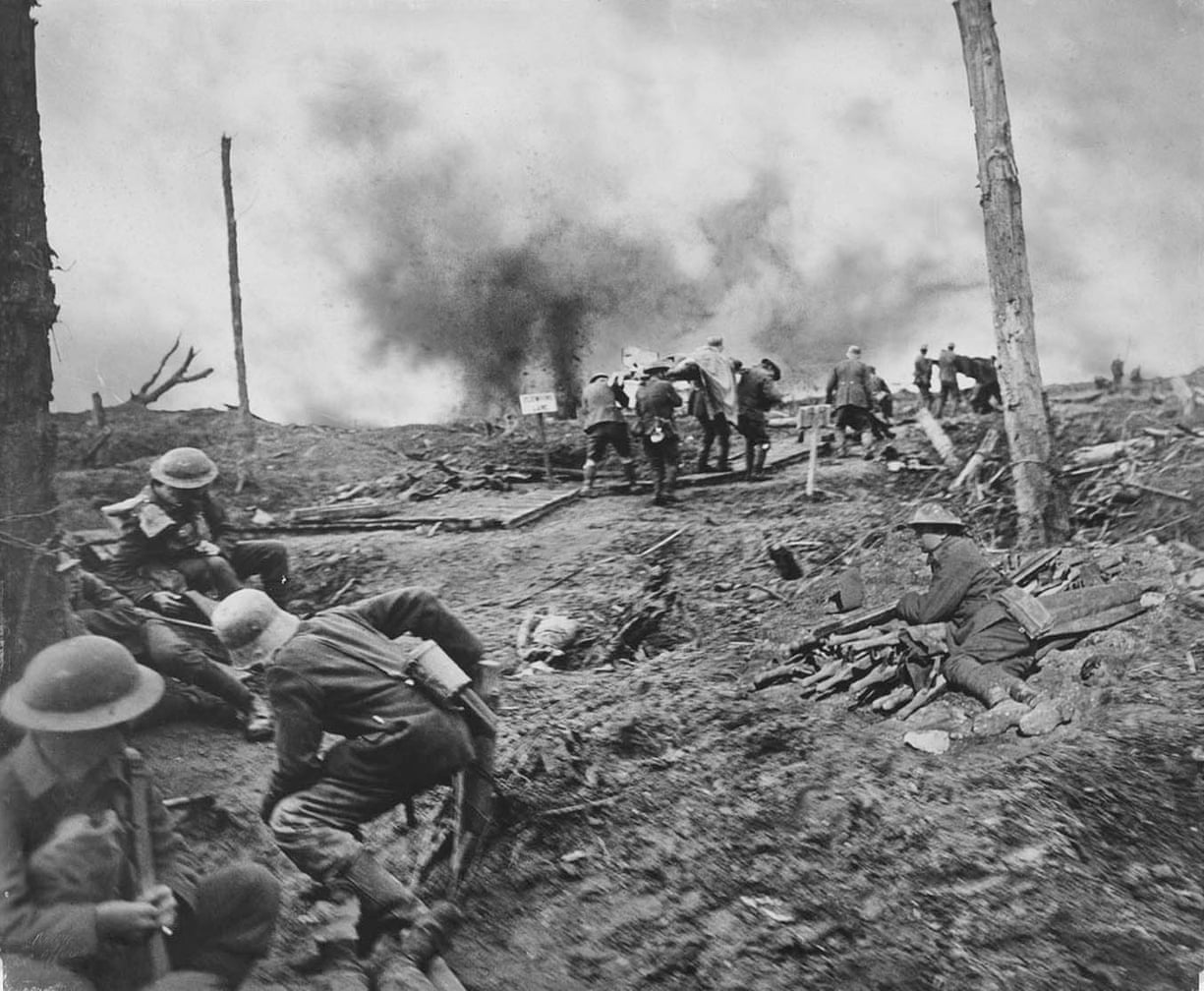
The walking wounded were the first to pass through the collecting post, followed by the stretcher cases.

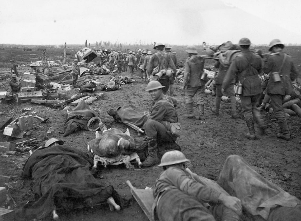
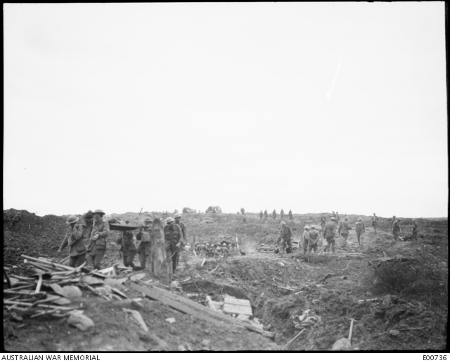
There were delays in moving them down the Menin Road (below; the first photograph is another Hurley), but according to the officer commanding the 3rd Field Ambulance these were ‘due to the amount of traffic – ammunition limbers, lorries, etc. – which held up the ambulance waggons.’  There was ‘practically no delay by enemy shelling on the road, which we all so greatly feared.’  (They were wise to do so; the reprieve was short-lived and  the German batteries soon re-registered on the Road). 

The Red Line was secured at 0611.

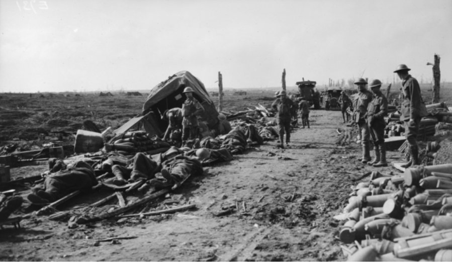
By 0700 the first walking wounded started to arrive at their Advanced Dressing Station, followed by the first stretcher cases at 0900 (again, the photographs below are by Hurley):

 The Blue Line was secured at 0815 and the Green Line at 1015.

At first the light railway was used to clear cases from the ADSs to the CCS, but the service was disrupted (in part by enemy shelling and part by a backlog at Remy) and lorries took over until the trains were restored by mid-morning.  In the first 24 hours 2,200 Australian and 1,000 British wounded passed through the twin ADSs; the proportion of walking wounded to stretcher-cases was roughly 3 : 1 (though, as I’ve noted previously, the distinction between the two was by no means hard and fast) (Australian Army Medical Services, pp. 208-9).

Further down the evacuation chain at the CCSs at Remy Siding casualties started to arrive ‘so rapidly as to cause some embarrassment’ but the stations started to take in by turns – a standard practice – and this successfully relieved the congestion: thereafter casualties arrived in a steady stream.    

Meanwhile stretcher bearers were moving up as the line advanced and new relay posts were being established.  From 1800 a light railway ferried the walking wounded directly from Birr Crossroads via the MDS to the CCS.

The official history has nothing but praise for the execution of Plumer’s plan, and Bean attributed the success of the first day to the artillery: ‘The advancing barrage won the ground; the infantry merely occupied it’ ( AIF, p. 761).  It is perfectly true that the German troops fell back under the sustained barrage, and that their counter-attacks were all repulsed, but this one-liner does an extraordinary disservice to the infantry that ploughed forward.

The medical history tells a more cautious story, and Butler emphasised that ‘throughout the day shell-fire was severe in the captured area’ – a situation with awful consequences for the troops and for the regimental stretcher-bearers who came to their aid.

Again Frank Hurley captures the dreadful scene that same day with a visceral immediacy:

I pushed on up the duck board track to Stirling Castle – a mound of powdered brick [below] and from where there is to be had a magnificent panorama of the battlefield. The way was gruesome & awful beyond words. The ground had been recently heavily shelled by the Boche & the dead and wounded lay about everywhere. About here the ground had the appearance of having been ploughed by a great canal excavator, & then reploughed & turned over and over again. Last nights shower too made it a quagmire; & through this the wounded had to drag themselves, & those mortally wounded pass out their young lives.

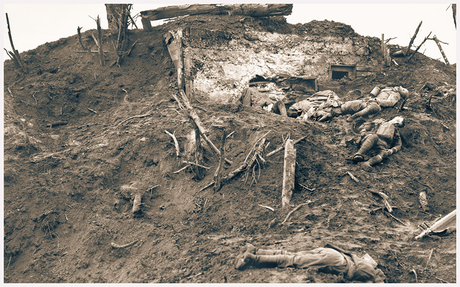
The shells shrieked in an ecstasy overhead, & the deep boom of artillery sounded like a triumphant drum roll. Those murderous weapons the machine guns maintained their endless clatter, as if a million hands were encoring & applauding the brilliant victory of our countrymen. It was ineffably grand & terrible, & yet one felt subconsciously safe in spite of the shell burst & splinters & the ungodly wanton carnage going on around.

]
I saw a horrible sight take place within about 20 yards of me. Boche prisoners were carrying one of our wounded in to the dressing station, when one of the enemy’s own shells struck the group. All were almost instantly killed, three being blown to atoms. Another shell killed four & I saw them die, frightfully mutilated in the deep slime of a shell crater. How ever anyone escapes being hit by the showers of flying metal is incomprehensible. The battlefield on which we won an advance of 1500 yards, was littered with bits of men, our own & Boche & literally drenched with blood (Diary, pp. 91-3 ).

And this, as Paul Ham reminds us, ‘was a battle that had gone well, in which everything had proceeded according to the plan’ (Passchendaele, p. 305).  The total British and Dominion casualties on that one day were around 21,000, expended in order to advance one and a half miles and to hold an area of 5.5 square miles.

Hurley recognised the extraordinary sacrifices made by those bringing in the wounded (above), and that same evening he wrote of his admiration for ‘the magnificent work of the stretcher bearers who go out in the thick of the strife to succour the wounded.’  Many of them were killed or injured, and by the end of the day one subaltern with the 3rd Field Ambulance reported that he had

ended up with four fit squads, fifteen men wounded, five missing and five worn out. Bearers all thoroughly done up.’

Not surprisingly, it was difficult for the bearers to find (let alone recover) all those who had been wounded.  On 28 September Harvey Cushing was operating on a British soldier at Mendinghem and asked him his division and regiment:

“Oxford Bucks; 20th Division, sir.”

“How can that be, they went over on the 20th, a week ago?”

“I went over with ’em, sir.”

He actually did, and has been lying for a week in a shell hole, until, during the attack of yesterday, someone found him. He said he had eaten nothing, for his bully beef went “agin” him and he wasn’t hungry — indeed thought he had been out of his head for two or three of the days. Then when it got dark he used to holler, but no one came….

He doesn’t seem to think his escapade anything out of the ordinary …  I asked him if he was in the barrage of yesterday morning and whether he knew there was an offensive under way. No, he just heard a terrible rattle and crawled up to the edge of his shell hole and waved his hand: some stretcher-bearers came along and took him away—that’s all he knows (A surgeon’s journal, p. 214).

You might think he was an outlier to all those accounts of rapid evacuation, physically and statistically, but he plainly wasn’t the only one.  And as the phased advance continued, so conditions deteriorated and the dangers increased.

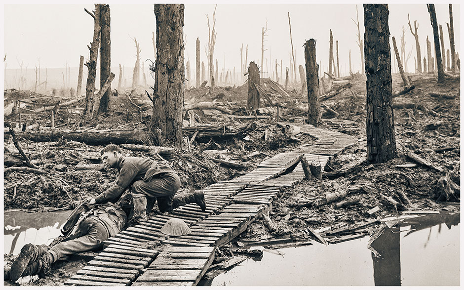
By 4 October the rains returned with a vengeance, and as the battle for Passchendaele ground on and the toll mounted so one nightmare day became indistinguishable from the next.  The carries became longer and longer; bearer parties found it harder and harder to find their way in a landscape (or what Samuel Hynes calls an anti-landscape) devoid of any permanent markers; even those areas stitched together by duckboards became dangerously slippery:

From 8 to 11 October, one medical officer reported,

‘the work was so heavy that for a large part of the time 6 men had to carry one stretcher – 8 and even 12 men were used in parts. Under these conditions the stretcher-bearers rapidly became exhausted, and absolutely so after 24 hours’ work. Usually they were relieved after 24 hours, but owing to the universal shortage some 36 and even 48 hour shifts were done. About 200 bearers (ambulance and infantry) were continually at work’ (Australian Army Medical Services, p. 234).

It’s not my purpose here to chart the unfolding geography of casualty evacuation in any detail – it was modelled on the plan for Menin Road but constantly adapted to the changing circumstances: ‘the medical scheme for each battle was an extension, at most a variant, of that for the preceding one; they were built up, as the line advanced, in the general “arrangements” described’ above: Australian Army Medical Services, p. 212) – but one stretcher-bearer epitomises the wrenching experience as well as anybody.  Frederick Noyes was with the 5th Canadian Field Ambulance, which was posted to Ypres on 1 November:

Who could ever forget those two weeks of the Passchendaele show? Looking back now it all seems like one long, weird, and terrible nightmare of water-filled trenches, zigzagging duck- walks, foul slime-filled shell-holes, half-buried bodies of dead men, horses and mules, cement pillboxes, twisted wire, shrieking shells, flying humming metal, crashing aerial bombs, stinking mud, water-logged and blood-soaked stretchers – a Slough of Despond such as even a Bunyan couldn’t conceive of.

That long, wearisome “carry” from Tynecot to Frost House was like a never-ending Via Dolorosa to all who made the journey. Passchendaele was the Somme multiplied and intensified ten times over. Dark, wet, hopeless days were followed by almost endless, cold, marrow-congealing nights of despair and exhaustion. Every man was soaked through to his skin the whole time we were there, and the added weight of his sodden, muddy uniform and equipment seemed to sink him deeper into the prevailing mire. After the first few hours we moved about like so many dazed automatons, stumbling, staggering, blundering along the heaving duck-walks and erupting roads – almost too stunned to care whether we lived or died and totally indifferent to the volcanoes of smoking shell-craters about us. The hours and days and nights seemed to merge with one another into a cruelly indefinite whole and it is doubtful if any man was afterward able to distinguish one Passchendaele day’s experiences from another (Stretcher bearers at the double! p. 177).

From geometries to geographies

It’s now possible to return the evacuation map and its clockwork timings that set my discussion in motion.  Maps like these display the system of evacuation as a linear geometry – an abstract grid of transmission lines that resemble what Fiona Reid in her Medicine in First World War Europe: Soldiers, Medics, Pacifists calls ‘a modernist dream’ – with no catastrophic breaks or nightmare tangles.  Many official and semi-official accounts endorsed this view of ‘the cogs of the evacuating machine’, beautifully oiled and running smoothly.

But it should now be clear that this is a representation of a space that never existed beyond the paper landscape on which the military offensives were themselves planned (cf. my ‘Gabriel’s Map’, DOWNLOADS tab).  Casualty evacuation was not only a geometry but also a geography; it was confounded by the bio-physical terrain through which the wounded were moved, and threatened by the savage continuity of military violence.  Routes constantly had to be changed, particularly for bearer parties, and aid posts and dressing stations were endlessly re-located as medical officers struggled to adapt to changed circumstances: improvising their own posts, sketching their own maps.  By extension, the analytical mapping of casualty evacuation cannot be limited to a cartography but necessarily extends to a corpography (see also ‘Corpographies’, DOWNLOADS tab) for, as Reid emphasises, the stories the wounded told of their journeys were, like so many of their injuries, ‘complicated and messy’.  There was a vital reciprocity between those journeys and the bodies that made them, and I’ll elaborate on that in later posts about the woundscapes of the Western Front.

Coda

On 22 September Harvey Cushing operated on a British soldier with a serious head injury, who had been wounded the previous day.  He had reached the Field Ambulance at 1230 and was admitted to the CCS at Mendinghem at 0647, whereupon he ‘got lost somehow in the crowded wards’ and was finally lifted on to Cushing’s table that afternoon.  Nothing unusual about any of that, except for Cushing knowing the time when his patient had reached the Field Ambulance.  He observed in passing ‘that they are noting the hour as well as the date since our discussion of last Tuesday’ (A surgeon’s journal, p. 209).  His journal records that meeting, presided over by General Sloggett, but there are no details of the discussion to which Cushing refers.  It’s all the more remarkable given the debate over the politics of speed – and the fact that the medical plan for Menin Road was all about minimising data recording and administration before the casualty was admitted to the CCS.

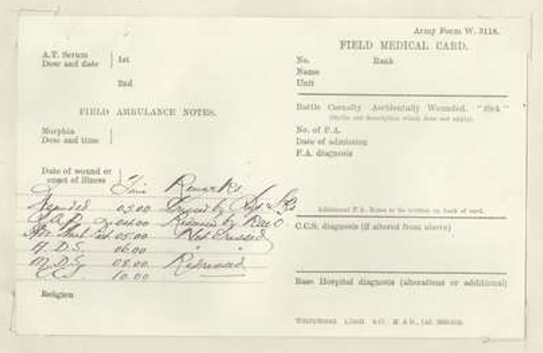
This leads me to the second Australian Army study I noticed at the start, which was carried out by the 7th Australian Field Ambulance on the Somme in July 1918 [see Appendix 16 of FA War Diary here].  It provides a useful counterpoint to the Battle of Menin Road.  Here too the objective was ‘to get the men as quickly as possible to the CCS’ and this too included minimising the number of dressings and treatments en route.  But where the plan for Menin Road also restricted data recording at the ADS and the MDS for the same reason, except for deaths and cases treated and returned to duty, the 7th FA added a layer by recording the time each casualty arrived at each station on the field medical card pinned to his tunic (below).

The corresponding scheme of evacuation is shown in the following sketch:

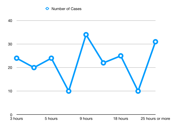
750 cases were recorded; 200 of these were retained at one of the intermediate stations (either because they were lightly wounded or because they needed emergency intervention); and of the remainder evacuation times were remarkably constant.  Including treatment and travel, it took casualties 1 hour 45 minutes to be brought from the Advanced Ambulance Post (where motor ambulances collected the casualties from the regimental stretcher bearers) to the Main Dressing Station at Saint Acheul, and a further 2 hours 15 minutes (including treatment at the MDS) before they reached the CCS at Crouy: the total elapsed time of 4 hours to travel those 22 miles was reduced for some ‘special cases’ to around 3 hours.

These travel times were maintained outside any ‘push’ (a major offensive) or a ‘stunt’ (a raid).  The FA provided statistics for two stunts that punctuated the steady process of attrition and these – unlike the schemas I’ve been describing thus far – incorporated the time it took stretcher bearers to retrieve casualties from the field and bring them to an aid post.  The first stunt kicked off at 0310 on 4 July; the time from the Advanced Ambulance Post to the CCS was more or less unchanged (around 3 hours 30 minutes) but factoring in   the time from the field to the Advanced Ambulance Post the first casualties took 5 hours 45 minutes to reach the CCS from the point of injury, and as the troops advanced further forward this increased until it took 9-10 hours for stretcher cases to reach the CCS.  The second stunt started at 2030 on 7 July, and the darkness combined with rain to change the calculus: it now took 4 hours 30 minutes to 5 hours to transfer casualties from the Advanced Ambulance Post, and the first casualties took around 7 hours to reach the CCS from the point of injury; others must have taken much longer though no details were given.

Islands of Sovereignty

When so many eyes are on the plight of refugees and asylum-seekers making the ever dangerous crossing of the Mediterranean, it’s important to attend to the wider geographies of marine migration and its policing.  So I really welcome news from Jeff Kahn of an intriguing and important new book, his Islands of Sovereignty: Haitian Migration and the Borders of Empire (forthcoming from Chicago later this year).

In Islands of Sovereignty, anthropologist and legal scholar Jeffrey S. Kahn offers a new interpretation of the transformation of US borders during the late twentieth century and its implications for our understanding of the nation-state as a legal and political form. Kahn takes us on a voyage into the immigration tribunals of South Florida, the Coast Guard vessels patrolling the northern Caribbean, and the camps of Guantánamo Bay—once the world’s largest US-operated migrant detention facility—to explore how litigation concerning the fate of Haitian asylum seekers gave birth to a novel paradigm of offshore oceanic migration policing. Combining ethnography—in Haiti, at Guantánamo, and alongside US migration patrols in the Caribbean—with in-depth archival research, Kahn expounds a nuanced theory of liberal empire’s dynamic tensions and its racialized geographies of securitization. An innovative historical anthropology of the modern legal imagination, Islands of Sovereignty forces us to reconsider the significance of the rise of the current US immigration border and its relation to broader shifts in the legal infrastructure of contemporary nation-states across the globe.

My own early work on Guantanamo [in ‘The Black Flag’: DOWNLOADS tab] nibbled at the remote edges of some of these issues, but Jeff makes them front and centre (as they should be), and the wider resonance of his argument in the face of  Trump’s wretched views on  immigration needs no gloss from me [though what Trump will do when someone tells him the US has maritime borders too is anyone’s guess].

Here is Jeff’s elaboration (taken from the book):

One of the overarching arguments of the book is that one must understand the valorization of law’s reign and the simultaneous desire for its evasion as two forces that have produced a potential dynamism within liberal sovereignty. That dynamism, having been activated through the historical conjuncture of Haitian migration, has reconfigured the spatiality of one of modernity’s core political forms–the nation-state itself. The goal is not to identify and typologize illiberal accretions on liberal political forms (R. Smith 1997) or to reveal the centrality of empire to American republicanism (Rana 2010) but to examine how the dialectics of the liberal rule of law continue to produce new geographies into the present. In this sense, the book is not just a dissection of liberal cosmology but a revelation of a liberal cosmogony of a kind by which state forms have been partially recreated as valued entities, both aesthetic and instrumental.

[Haitian] Interdiction [operations] emerged initially as a search for spaces of flexible bureaucratic intervention unburdened by the dense layers of proceduralism iconic of law’s rule. But what accounted for this urgent turn to the relative freedom of the seas? When Haitians began arriving in South Florida in the early 1970s, they encountered what was then an embryonic asylum-processing regime that granted the INS frontline screeners and district directors nearly unreviewable discretion to dispose of Haitian claims, which were, in almost every instance, denied as being merely “economic” in nature. The litigation and political organizing that emerged out of these early cases developed into a coalition of Haitian exiles, leftist activists, mainstream religious networks, and tenacious civil rights attorneys who would, through an unprecedented process of what I call “siege litigation” (chapter 2), effectively shut down the INS’s capacity to expel Haitians from South Florida for the better part of a decade. A space-producing dynamic would soon emerge around an energetic polarity of opposing litigation camps, each focused in different ways on the dilemma of what in government circles had already by that time become known as “the Haitian problem.” This book examines the ways new geographies were fashioned in these contests and what such space-making processes can reveal about existing cosmologies of law’s rule, including their shifting aesthetic and moral geographies.

You can get a taste of Jeff’s arguments about those legal geographies in his brilliant essay,  ‘Geographies of discretion and the jurisdictional imagination. PoLAR: Political and Legal Anthropology Review 40 (1)  (2017) 5-27.

The modernist ideal of liberal constitutionalism affords jurisdiction a special place as the organizing principle behind the distribution of official state power. Nonetheless, little attention has been paid to the intricate spatial infrastructures that give jurisdiction its form.  In this article, I argue that the complex architectures that undergird various jurisdictional registers combine to segment material and virtual landscapes into historically specific, multilayered geographies of discretion, dictating where, when, and to whom various institutions are permitted to speak the law. Looking to politicized litigation and advocacy over the rights of Haitian asylum seekers in the United States, I demonstrate how battles over jurisdictional cartographies can both instantiate and remake the spatiality of nation-states and the cosmologies of liberal sovereignty on which they rest.


Here’s the main Contents list for the book:

1 • The Political and the Economic
2 • Border Laboratories
3 • Contagion and the Sovereign Body
4 • Screening’s Architecture
5 • The Jurisdictional Imagination
6 • Interdiction Adrift

And, as I’ve noted before, since this comes from an American scholarly press the price of the paperback and e-book is eminently reasonable.  Commercial behemoths (oh, please let them soon become mammoths) take note!

The eyes have it…

The Disorder of Things has hosted a symposium on Antoine Bousquet‘s The eye of war: military perception from the telescope to the drone (Minnesota UP, 2018).  Antoine’s introduction is here.

There were four other participants, and below I’ve linked to their commentaries and snipped extracts to give you a sense of their arguments: but it really is worth reading them in full.

Kate Hall‘Linear Perspective, the Modern Subject, and the Martial Gaze’

For Bousquet this future of globalised targeting that the birth of linear perspective has brought us to throws the role of the human into question. With the move of perception into the realm of the technical, Bousquet sees that perception has become a process without a subject, and as human agency is increasingly reduced, so does the possibility for politics – leading, perhaps much like the concerns of the Frankfurt School, to passivity and a closing of the space of critique. For Bousquet the figure that captures this positioning or transformation of the human, and the image that ends the book, is the bomber instructor recording aircraft movement within a dark camera obscura tent. As Bousquet concludes, “…the camera obscura’s occupant is both a passive object of the targeting process and an active if compliant agent tasked with the iterative process and optimization of its performance. Perhaps this duality encapsulates the martial condition we inhabit today, caught between our mobilization within the circulatory networks of the logistics of perception and the roving crosshairs of a global imperium of targeting – and all watched over by machines of glacial indifference.” 

If this is the figure that encapsulates the condition of the present, Bousquet has shown in Eye of War how its foundations are found in the early modern period. And in tracing this history, it is clear the future does not look promising for humans (both as passive subjects and as objects of lethal surveillance). But Bousquet does not give us a sense of how we might change course. Eye of War does not ask, where is the space for politics in this analysis of the present?

Dan Öberg‘Requiem for the Battlefield’

While the culminating battle of the Napoleonic wars, Waterloo, was fought at a battlefield where 140,000 men and 400 guns were crammed into an area of roughly 3,5 miles, the latter half of the 19th century becomes characterised by the dispersal and implosion of the battlefield. As Bousquet has directed our attention to in his work, after the birth of modern warfare the battlefield dissolves due to the increased range of weapons systems. Its disappearance is also facilitated by how the military logistics of perception conditions the appearances of targets, particularly through how the “eye of war” manages to move from the commander occupying a high-point next to the field of battle, to being facilitated by balloons, binoculars, aerial reconnaissance, satellites, algorithms, and cloud computing. It is as part of this process we eventually reach the contemporary era where targeting is characterised by polar inertia, as targets arrive as digital images from anywhere on the globe in front of a stationary targeteer. However, I would like to argue that, parallel to this, there is a corresponding process taking place, which erases and remodels the battlefield as a result of the military disposition that is born with the operational dimension of warfare.

To grasp this disposition and its consequences we need to ponder the fact that it is no coincidence that the operational dimension emerges at precisely the time when the traditional battlefield is starting to disappear. As The Eye of War outlines, global targeting is enabled by a logistics of perception. However, the demand for maps and images as well as the attempts to make sense of the battlefield arguably receives its impetus and frame of reference from elsewhere. It finds its nexus in standard operating procedures, regulations, instructions and manuals, military working groups, administrative ideals, organisational routines, and bureaucratic rituals. And, as the battlefield is managed, coded, and homogenised, it simultaneously starts to become an external point of reference, enacted through operational analysis and planning far from the battlefield itself.

Matthew Ford‘Totalising the State through Vision and War’

The technologies of vision that Antoine describes emerge from and enable the political and military imaginaries that inspired them. The technological fix that this mentality produces is, however, one that locks military strategy into a paradox that privileges tactical engagement over identifying political solutions. For the modern battlefield is a battlefield of fleeting targets, where speed and concealment reduce the chance of being attacked and create momentary opportunities to produce strategic effects (Bolt, 2012). The assemblages of perspective, sensing, imaging and mapping, described in The Eye of War may make it possible to anticipate and engage adversaries before they can achieve these effects but by definition they achieve these outcomes at the tactical level.

The trap of the martial gaze is, then, twofold. On the one hand, by locking technologies of vision into orientalist ways of seeing, strategies that draw on these systems tend towards misrepresenting adversaries in a manner that finds itself being reproduced in military action. At the same time, in an effort to deliver decisive battle, the state has constructed increasingly exquisite military techniques. These hold out the prospect of military success but only serve to further atomise war down tactical lines as armed forces find more exquisite ways to identify adversaries and adversaries find more sophisticated ways to avoid detection. The result is that the military constructs enemies according to a preconceived calculus and fights them in ways that at best manage outcomes but at worst struggle to deliver political reconciliation.

Jairus Grove, ‘A Martial Gaze Conscious of Itself

If we take the assemblage and the more-than-human approach of Bousquet’s book seriously, which I do, then we ought not believe that the dream of sensing, imaging, mapping, and targeting ends with the intact human individual. As an early peak at what this could become, consider Bousquet’s review of the late 1970’s research on ‘cognitive cartography’ and the concern that human technology would need to be altered to truly take advantage of the mapping revolution. More than the development of GIS and other targeting technologies, the dream of cognitive mapping and conditioning was to manage the complex informatics of space and the human uses of it from the ground up. That is in the making of user-friendly human subjects. One can image targeting following similar pathways. The “martial gaze that roams our planet” will not be satisfied with the individual any more than it was satisfied with the factory, the silo, the unit, or the home.

The vast data revolutions in mapping individual and collective behavior utilized in the weaponization of fake and real news, marketing research, fMRI advances and brain mapping, as well nanodrones, directed energy weapons, and on and on, suggest to me that just as there has never been an end of history for politics, or for that matter war, there will be no end of history or limit to what the martial gaze dreams of targeting. I can imagine returns to punishment where pieces of the enemy’s body are taken. Jasbir Puar’s work on debility suggests (see our recent symposium) already suggests such a martial vision of the enemy at play in the new wars of the 21st century. Following the long tails of Bousquet’s machinic history, I can further imagine the targeting of ideas and behaviors for which ‘pattern-of-life’ targeting and gait analysis are use are only crude and abstract prototypes.

If we, like the machines we design, are merely technical assemblages, then the molecularization of war described by Bousquet is not likely to remain at the level of the intact human, as if individuals were the martial equivalent of Plank’s quanta of energy. The martial gaze will want more unless fundamentally interrupted by other forces of abstraction and concretization.

Antoine‘s response is here.

Lots to think about here for me – especially since one of my current projects on ‘woundscapes‘ (from the First World War through to the present) is located at the intersection of the military gaze (‘the target’) and the medical gaze (‘the wound’) but rapidly spirals beyond these acutely visual registers, as it surely must….  More soon!

Selling War

When there were endless real bookshops for me to haunt, I lost count of the number of times I’d take a book from the shelf, seduced by its lead title, only to put it back once I saw what came after the colon.   But that isn’t always a fail-safe strategy, and I’ve received news of a new book by Alex Fattawhere that really wouldn’t be smart.  Guerrilla Marketing has a relevance far beyond Colombia (interesting and important though that is in its own right):

Brand warfare is real. Guerrilla Marketing details the Colombian government’s efforts to transform Marxist guerrilla fighters in the FARC into consumer citizens. Alexander L. Fattal shows how the market has become one of the principal grounds on which counterinsurgency warfare is waged and postconflict futures are imagined in Colombia. This layered case study illuminates a larger phenomenon: the convergence of marketing and militarism in the twenty-first century. Taking a global view of information warfare, Guerrilla Marketing combines archival research and extensive fieldwork not just with the Colombian Ministry of Defense and former rebel communities, but also with political exiles in Sweden and peace negotiators in Havana. Throughout, Fattal deftly intertwines insights into the modern surveillance state, peace and conflict studies, and humanitarian interventions, on one hand, with critical engagements with marketing, consumer culture, and late capitalism on the other. The result is a powerful analysis of the intersection of conflict and consumerism in a world where governance is increasingly structured by brand ideology and wars sold as humanitarian interventions.

Full of rich, unforgettable ethnographic stories, Guerrilla Marketing is a stunning and troubling analysis of the mediation of global conflict.

The resonance of Guerilla Marketing clearly transcends its subtitle, as this tantalising extract makes clear:

Total mobilization is no longer a matter of a fluid transition from peace to war, but a matter of the continual co-presence of the two in a hot peace in which everywhere is always a potential scene of violence.  As commentators frequently note, the Global War on Terror is unbounded in scope and duration, an unending concatenation of episodes that render the world a battlefield from Waziristan, which has borne the brunt of drone warfare, to suburban Watertown, Massachusetts, in the wake of the Boston Marathon bomb attacks of 2013. What connects sites as disparate as Waziristan and Watertown is not only the War on Terror but marketing as a system of global provisioning that is productive of affective attachments. I borrow the idea of affect as a form of infrastructure from anthropologist Joseph Masco, who deftly teases out continuities between the Cold War and the War on Terror. For Masco, this affective infrastructure is built by the national security state, expansive in the wake of the “ongoing injury” of the September 11 attacks.  “Affect,” Masco writes, “becomes a kind of infrastructure for the security state, creating the collective intensities of feeling necessary to produce individual commitments, remake ethical standards, and energize modes of personal, and collective, sacrifice.”

The layering of national security affect, primarily paranoia and fear, I argue, cannot be separated from the aspirational affect of consumer culture, for the two have coevolved. At the height of the Cold War, for instance, advertisements pitched “Luxury Fall- Out Shelters” to people who would prefer to wait out a nuclear apocalypse in comfort. Such advertisements normalized the very idea of nuclear warfare and the paranoia it generated. Similarly, George W. Bush’s call on Americans to go shopping one week after September 11, 2001, mobilized consumption as a means of coping with the Global War on Terror. I take as given the idea, demonstrated by historical accounts of the coevolution of marketing and warfare in the twentieth century, that marketization and militarization are deeply interpenetrated. I am fascinated by how their convergence shapes an affective mode of governance in the early twenty-first century, a moment when simmering fears of an everywhere war and the rising aspirations of the global middle classes expand in tandem. It is more than a little curious that in the 2000s, just as war diffused further into everyday life, everything—nations, militaries, cities, universities, individual selves— became brands.

The language of the convergence of marketing and militarism is revealing. Targeting, for example, serves as a switch that connects the marketing nation and the security state. As marketers study, segment, and create new publics to target, the military compiles lists of targets to monitor and, at the right moment, destroy. A drive toward ever- greater precision unites both practices of targeting. Each year marketers improve their ability to micro- target tightly defined demographic groups by tracking users across the internet with algorithmic intelligence.  Similarly the military, through the use of special forces and drone warfare, creates micro-kill zones. In the words of Grégoire Chamayou, a French theorist of drone warfare, “The zone of armed conflict, having been fragmented into miniaturizable kill boxes, tends ideally to be reduced to the single body of the enemy-prey”— modern warfare as hunting. Whether it’s data capitalism’s drive to psychologically profile individual consumers or the whack- a-mole logic of twenty-first-century counterinsurgency, this scaling down to the individual approaches a vanishing point: advertising as nonadvertising, war as nonwar. Neither negation is neutral, nor is their entanglement haphazard. To the contrary, I would like to suggest that in this double negation there lies a key to understanding the state of the relationship between war and capitalism in the early twenty- first century.

Enter the double meaning of this book’s title, guerrilla marketing, which in business parlance is code for a bundle of tactics, most of which seek to invisibilize the sales pitch. Tom Himpe, an advertising intellectual, describes this tendency as “advertising that blends in seamlessly with real entertainment, real events or real life to the extent that it is not possible to tell what is advertising and what is not.”  Drawing upon the legacy of guerrilla warfare as articulated by Che Guevara and Mao Zedong, guerrilla marketing draws its strength from camouflage. But marketing’s camouflage aspires not merely to blend into the background but to act upon it. Branding, I argue, operates as an activist form of camouflage that seeks to subtly transform the environment. As an instrument of total mobilization, brands have proved to be modular weapons of productive persuasion, from the black flag of ISIS and its calls to mobilize individuals alienated from the West to a real estate mogul’s use of brand strategies to bluster his way to the White House. As an emergent phenomenon of extraordinary political consequence, brand warfare is ripe for critical analysis.

Since Guerilla Marketing comes from a US publisher (Chicago UP) the paperback is not pitched at a silly-extortionate price; there’s an e-book too.  More here.

A museum without borders

Following from my previous post – the same issue of Radical Philosophy (2.03) includes an excellent essay on ‘The Palestinian Museum‘ at Birzeit by Hanan Toukan.

It opens with a series of sharp questions about the very idea of such a museum:

How are we to think about a museum that represents a people who not only do not exist on conventional maps but who are also in the process of resisting obliteration by one of the most brutal military complexes in the world? What is, and what can be, the role of a museum in a violent colonial context compounded by the twin effects of imperialism and capitalism? Whom does the museum speak for in such a context? And what can or should it say to a transterritorial nation while physically located in a supposed state-to-be, that has no real prospect of gaining control over its land, water or skies through current international diplomatic channels?

Hanan’s discussion is framed by four issues:

First, the convoluted, bureaucratic and deceptive nature of the Oslo Peace Process and the new phase of colonisation that it inaugurated in 1993. This predicament, which has been described as one of living in a ‘postcolonial colony’ is largely defined by the paradox of living in a state without sovereignty in the West Bank and Gaza under the guise of a diplomatic process leading toward a two-state solution. Under this regime, the Palestinian National Authority (PNA), established in 1994 as an outcome of the now unpopular Oslo Peace Accords, did not gain full sovereignty for itself or the Palestinian people it‘represents’. Rather, it became the middleman of the Israeli Occupation, managing security and repressing Palestinian dissent on behalf of Israel through its own internal military and intelligence apparatus, helping to intensify Israeli colonial strategies of spatial segregation and economic control. At the same time, despite its increasing unpopularity the PNA has continued to act as the internationally recognised representative of a state-to-be in international diplomacy. This role has necessitated its participation in cultural diplomacy and top-down identity formation in an attempt to rebrand the image of Palestinians as non-violent and modern global citizens residing within the 1967 borders – processes that are key to understanding how and why the Palestinian Museum has, from its inception, had to think about representing the story of the Palestinian people outside the limits of the diplomatically sanctioned, yet now probably defunct, two-state solution.

Second, ‘ongoing Israeli colonial practices of cultural exclusion and military domination’ that materially limit the space within which it was possible for the museum to emerge [when I see images like the one above, from Frieze, I can’t help but think of Eyal Weizman‘s wonderful work on the optical geometry of Israeli occupation] – and third, closely and crucially linked, the restrictions imposed (and to some degree subverted) by ‘the European museum’s western-centric yet universalising mission of acquiring, conserving and displaying aesthetic objects as part of the project of constructing nation-states and indeed modernity itself.’

And finally, ‘the wave of state-supported building and renovation of museums and other art institutions underway largely in the Arab Gulf states but also in Lebanon, Egypt, Kuwait and to a lesser extent Jordan, from which the Palestinian Museum is arguably set apart by virtue of its status as an institution representing a transterritorial and stateless nation.’

As should be obvious from even these brief passages, the essay’s reach extends far beyond the museum itself.

Those who claim to see everything from the sky

A new issue of Radical Philosophy (2.03) is online here.  Among the highlights is an extended interview with Trinh T. Minh-ha, ‘Forgetting Vietnam‘.  It spirals around her film of the same name (2015 but premiered at Tate Modern in December 2017, when the interview by Lucie Kim-Chi Mercier took place).

It’s wide ranging, as you’d expect, and includes these reflections on her decision to avoid the by now hegemonic images of the American war in Vietnam:

In the making of Forgetting Vietnam one of the commitments I kept in relation to war images was the following: most of the films made on the war in Vietnam show you the horrors of war mainly through what constitutes the sensational in cinema. So: explosions, bombings, killings, bodies, buildings and environment being burned, mutilated and blasted; violent, bloody scenes with wounds oozing open (blood as depicted in mainstream films is cheap), and then suffering that is strident – noisy, and loud. Such a depiction of war amply exploited on screen for spectacular effect is something that I do not want at all to have in my films. Showing brutality has its journalistic function, but violence for violence’s sake is how the media continue to desensitise human suffering and distress, as well as how the entertainment industry claims to serve a consumer society steeped in violent media.

And then you have the other kinds of films evolving from this war, of which you really have to ask: Whose interest does it serve? For most of the time what’s covertly at stake are American interests. Whether their politics is liberal or conservative, mainstream films made in the name of the war in Vietnam speak to one side of the war and contribute to sustaining American hegemony. So, sometimes during one of these films’ screenings, I would be sitting in the audience with other Vietnamese people, and they would look at me and say: Do you think it has anything to do with us? [Laughter]

With Forgetting Vietnam, viewers often wonder why there are no images of the war, but the war is all over, whether visible or otherwise. Its traces are everywhere, present in the environment, in people’s memory, in their speech and daily rituals.

This segues into a perceptive and provocative discussion of the meaning of ‘victory’:

In Forgetting Vietnam and especially in my last book Lovecidal, it is the victory mindset that I see regulating war, paradoxically bringing together the two warring sides. It is a mindset that divides the world into winners and losers. When you think about it, it is absurd to always want to be the winner and to always consider the other to be the loser. Heroism righteously trotted out to disavow suffering and distress partakes in such inanity. In today’s ‘new wars’ it might be more appropriate to say that the line between winning and losing has been so muddled that there is no longer a loser. Every war champion claims victory at all cost, and hence, battles are only fought between victor and victor.

For example, one of the most striking and puzzling moments for me during the 1991 Gulf War was when the Americans were declaring victory over Iraq. As television screens were filled with talk about the war coming to an end, thanks to the glorious results of Operation Desert Storm and the swift victory by American-led coalition forces, we, earnest spectators, were briefly shown images of Iraqi’s celebrating their own ‘victory’. This is what in Lovecidal I call the ‘Twin Victories’. Of course, for Western media reporters, it was mind-boggling to see such a celebration when Iraq had lost the war. Everyone said at the time that Saddam Hussein was deceiving his people. For me, it’s not the same concept of victory. Same word, similar striving, but not the same thing. The West is always probing and measuring the other in their terms, but it would be more relevant to ask seriously why Iraq claimed victory where the Western world only saw defeat. As with the Algerian or the Vietnam wars, the West may obtain military victory temporarily via a power from the sky, but nations of lesser means ultimately gain political victory via a power from the underground. These persist through elaborate subterranean structures built to fight those who claim to see everything from the sky.

That last sentence is haunting and, in the fullest sense of the word, profound.

‘Is this thy body’s end?’

There are all sorts of ways in which the war on Syria has been a throwback to the First World War – and all sorts of differences too – but today brought news of yet another (and, unusually, a welcome one).  Peter Walker reports for the Guardian:

The UK government is taking part in a pioneering international aid project which could see consignments of maggots sent to crisis zones such as Syria as a simple and effective way to clean wounds, it has been announced.

So-called maggot therapy has been used since the first world war, when their efficacy in helping wounds heal was discovered by accident, and it is sometimes used in the NHS, for example to clean ulcers.

The initiative, co-sponsored by the Department for International Development (DfID), will develop techniques to help people in conflict zones or areas affected by humanitarian crises to use maggots where other medical facilities might not be available, such as Syria and South Sudan.

Over at the Telegraph Sarah Newey adds:

Modern larvae treatment was developed following WWI after an American scientist, William Baer, noticed the benefits of maggots on soldiers wounds. Today the therapy is used in hospitals in developed countries, including the NHS, but they are yet to be used in war zones.

While photos of the maggots at work are unsavory, the treatment is highly effective.

Flies are reared in a lab, where their eggs are sterilised. The hatched maggots are then grown for a day or two, before they are applied to skin and soft tissue wounds either directly or in a biobag, which is wrapped around the injury.

Not only do the maggots remove dead tissue and flesh, but they control infection as their spit and saliva act as a natural disinfectant and promote healing. The maggots can be used to treat anything from burns to bedsores to gunshot wounds, and are left on an injury for two to four days.

The martial history of maggots is an interesting one.

In ‘Trauma Geographies‘ I described the experience of one young soldier, John Stafford, who was wounded on the Somme in the early hours of 8 August 1916, and I’ll draw on that account here.  He managed to crawl (and fall) into a shell-hole, where he examined his wound:

‘A bullet had passed through the flesh of the upper left thigh and entered the extreme inner high point of the right leg.  The thigh bone was considerably shattered, the bullet having travelled downwards towards the knee.  My field dressing was used and I lay flat again…’

There was no sign of rescue.  His thirst increased as the sun climbed higher, but he knew nobody would venture out to rescue him until it was dark.

When night fell his hopes rose, though he was weak from loss of blood, but still nobody came.  The next day the bleeding had stopped so Stafford removed the field dressing and to his horror ‘discovered that it was one mass of white grubs … I saw that my wounds were infested with maggots.’ Sickened, he hurled the heavy dressing away, but worse was to come:

‘Eventually the maggots spread over my leg from hip to knee and then settled on the other leg which was not so badly wounded.  Occasionally I looked at their swelling rhythm, then finally turned away in disgust.’

He was eventually – and accidentally – rescued, but the maggots had probably already saved his life.  In eating the damaged flesh they had performed a ‘natural’ debridement of the wound,

Stafford’s experience was by no means unique.  It was not uncommon for wounded men to lie out in the open for days before they were recovered by stretcher-bearers, and often their wounds became infected – but the problem was bacterial infection not maggot infestation.

That same month (and in more or less the same place) Captain Lawrence Gameson was stationed with the RAMC’s 45th Field Ambulance in a shattered cellar at Contalmaison (above).  It was a bruising experience;, and he said there ‘was hardly a part of the body I did not see cut or exposed’:

Maggot invasion was common. I can recall an unconscious man who arrived with part of a frontal lobe protruding through a hole in his skull. The protruding portion of brain was moving with maggots. When men had had to be left out wounded for some time, often their shoulders, buttocks or whole back were invaded by the creatures in the areas of skin compressed by the weight of their immobilised bodies. One man I saw had been lying out because both his legs were wounded. Prolonged pressure had caused necrosis of the skin over his buttocks and of the superficial portions of muscle beneath it. Maggots had invaded the deeper tissues. I had to pick them out with long forceps. The man was unaware of his condition. Maggot invasion was always accompanied by a foul smell, since it flourished only in tissues undergoing some degree of decomposition. As a rule, the victim did not notice the stink, or did not know that it came from his own body if sensitive enough to notice it.

The association of maggots with death, decay and decomposition was pervasive.  Gameson described how he was called to extricate the body of a dead German soldier from a captured dugout:

He had fallen head foremost and was stuck there. On my preliminary examination in the dim light I could see only his field boots. I had come without my torch. Subsequently, on looking closer, I found that his flesh was moving with maggots. More precisely, I noticed that portions of his uniform were heaving up and down at points where they touched the seething mass below.

The smell was pretty awful. None of the men would touch him, although troops as a rule are not noticeably fastidious. The job was unanimously voted to me, because it’s supposed, quite wrongly, that doctors don’t mind. I went down the stairway with a length of telephone wire and lashed it round the poor chap’s feet. We hauled him up and dragged him away for some distance. The corpse left behind it a trail of wriggling, sightless maggots…

And yet, writing in the British Medical Journal on 3 March 1917 about the treatment of compound fractures, Captain Basil Hughes observed that ‘the presence of maggots in … wounds seems to exert an inhibitory action on the growth of the most virulent bacteria, and so acts beneficially.  Maggots only thrive in dead tissue and seem to hasten its removal.’

This should have been – could have been – a crucial finding, for Hughes also emphasised that ‘all shell wounds are bound to become infected, whatever care be taken’, and listed ‘the bacteria most to be feared’.  But it was those other associations – the smell of decay and the seething sight of the maggot-riddled bodies – that inhibited an appreciation of the therapeutic agency of maggots.

As Sarah notes, William Baer (left) had made a similar observation while treating two soldiers also with compound fractures of the femur.  These were among the most serious wounds of the war because the penetration of the skin by the bone made them peculiarly vulnerable to sepsis.  In 1917, he wrote,

‘two soldiers with compound fractures of the femur and large flesh wounds of the abdomen and scrotum [shades of Trey Parker] were brought into the hospital. These men had been wounded during an engagement and in such a part of the country, hidden by brush, that when the wounded of that battle were picked up they were overlooked. For seven days they lay on the battlefield without water, without food, and exposed to the weather and all the insects which were about that region. On their arrival at the hospital I found that they had no fever and that there was no evidence of septicaemia or blood poisoning. Indeed, their condition was remarkably good, and if it had not been for their starvation and thirst, we would have said they were in excellent condition. When I noticed the extent of the wounds, of the thigh particularly, I could not but marvel at the good constitutional condition of the patients. At that time the mortality of compound fractures of the femur was about seventy-five to eighty per cent…’

He continued:

‘I could not understand how a man who had lain on the ground for seven days with a compound fracture of the femur, without food and water, should be free of fever and of evidences of sepsis. On removing the clothing from the wounded part, much was my surprise to see the wound filled with thousands and thousands of maggots, apparently those of the blow fly. These maggots simply swarmed and filled the entire wounded area. The sight was very disgusting and measures were taken hurriedly to wash out these abominable looking creatures. Then the wounds were irrigated with normal salt Solution and the most remarkable picture was presented in the character of the wound which was exposed. Instead of having a wound filled with pus, as one would have expected, due to the degeneration of devitalized tissue and to the presence of the numerous types of bacteria, these wounds were filled with the most beautiful pink granulation tissue that one could imagine. There was practically no bare bone to be seen and the internal structure of the wounded bone, as well as the surrounding parts, was entirely covered with the pink, rosy granulation tissue which filled the wound. Bacterial cultures were made and, while one found a few Staphylococci and Streptococci still remaining, they were very few in number and not sufficient at that time to cause a pus formation. These patients went on to healing, notwithstanding the fact that we removed their friends which had been doing such noble work.’

Bauer drew on these findings to pioneer the use of ‘maggot therapy’ (myiasis) –  but he did so at the Children’s Hospital in Baltimore ten years after the war ended.  His first step was to grow maggots on raw meat ‘so he could observe their effect on destroying tissues,’ a colleague recalled, setting up the experiment in the hospital’s dining hall—’an unfortunate location for unwitting visitors’.

In fact, the use of maggot to treat wounds has an even longer history.  They have been a common resource in many forms of indigenous medicine for thousands of years, and within a recognisably Western tradition Baron Dominique Larrey, Napoleon’s field surgeon (above), had observed their beneficial effects a hundred years before Bauer:

‘While the process of the suppuration of their wounds was going on, the wounded were much annoyed by the worms or larvae of the blue fly… These larvae are indeed greed only after putrefying substances, and never touch the parts which are endowed with life.’

Ironically, this was during the Syrian campaign (1798-1801).

(If you want more after all that, try here and here).

The War Yet To Come

I fell in love with Beirut (its people and its food!) on my first visit, and I’ve returned many times since.  The first was in 2005, when I gave  a plenary lecture to a conference on ‘“America in the Middle East/The Middle East in America” at AUB.  I was back in 2006, shortly after the Israeli bombing of Beirut’s southern suburbs during the summer, and my plenary lecture to the Arab World Geography conference referred directly to those attacks (and marked the start of my work on aerial violence): see ‘In another time zone, the bombs fall unsafely’ (DOWNLOADS tab).

I took my title from a poem by Blake Morrison, ‘Stop’ (above), which was reprinted in an anthology to aid children’s charities in Lebanon compiled by Anna Wilson after the Israeli attacks.

Most of what I know about Beirut, both at first hand and from reading, comes from the brilliant work of Mona Fawaz and her students – I vividly remember Mona taking me around the rapid-fire construction taking place in the southern suburbs amidst the rubble from the air strikes – so I’m really pleased to see Emma Shaw Crane‘s appreciation of Hiba Bou Akar‘s For the War Yet to Come: Planning Beirut’s Frontiers over at Public Books.

Emma explains:

Halfway through Bou Akar’s fieldwork, the “ghost of the civil war returned,” with the events of May 7, 2008, the worst sectarian fighting in Beirut since the civil war. When a Sunni Future Movement–led national government declared Hezbollah’s telecommunications infrastructure illegal, street battles broke out across the southern suburbs between Hezbollah, allied with Haraket Amal, and the Future Movement and the allied Druze PSP. The southern peripheries were once again battlegrounds. This time, the fight was for infrastructure.

Urbicide is the targeted destruction of cities as a tactic of war. The violence chronicled here is not aerial annihilation—hospitals and homes reduced to rubble—but the “gradual construction of buildings and infrastructure” in ways that collapse boundaries between war and peace, militarizing everyday life. A window in an apartment building is at once a source of light and a future sniper location; a ruin may be uninhabitable, but the land beneath it marks the edge of a territory. This doubleness saturates life on the on the peripheries of Beirut, where “every built space is a potential future battle space.”

For the War Yet to Come is a feminist and postcolonial critique of a masculinized geography of urban militarism that favors the spectacular and the sublime. This vision of the city at war is blindingly technological and curiously devoid of people, as if seen from above (perhaps from a fighter jet). Bou Akar’s Beirut is peopled, swirling with rumor. It is the site not of anonymized destruction but of calculated and complex construction.

Succinct and to the point, though I think it’s important to use the one to undercut the other: to reveal the masculinism that inheres in aerial violence (see below: the text is from John Steinbeck‘s appreciation [sic] of USAAF bomber crews in the Second World War, Bombs Away!; I used it in my Tanner Lectures) ––

–– but also to show that those who live in cities under siege are neither voiceless nor without creative, collective  agency (something I’ve tried to achieve in my work on Syria: see the GUIDE tab).

You can access the opening section of For the War Yet to Come here, and here is a syposis of the book:

Beirut is a city divided. Following the Green Line of the civil war, dividing the Christian east and the Muslim west, today hundreds of such lines dissect the city. For the residents of Beirut, urban planning could hold promise: a new spatial order could bring a peaceful future. But with unclear state structures and outsourced public processes, urban planning has instead become a contest between religious-political organizations and profit-seeking developers. Neighborhoods reproduce poverty, displacement, and urban violence.

For the War Yet to Come examines urban planning in three neighborhoods of Beirut’s southeastern peripheries, revealing how these areas have been developed into frontiers of a continuing sectarian order. Hiba Bou Akar argues these neighborhoods are arranged, not in the expectation of a bright future, but according to the logic of “the war yet to come”: urban planning plays on fears and differences, rumors of war, and paramilitary strategies to organize everyday life. As she shows, war in times of peace is not fought with tanks, artillery, and rifles, but involves a more mundane territorial contest for land and apartment sales, zoning and planning regulations, and infrastructure projects.

Here is the list of Contents, but if you go here you can find a detailed abstract for each chapter:

Prologue: War in Times of Peace
Chapter 1: Constructing Sectarian Geographi
Chapter 2: The Doubleness of Ruins
Chapter 3: The Lacework of Zoning
Chapter 4: A Ballooning Frontier
Chapter 5: Planning without Development
Epilogue: Contested Futures

The Longest Journey

The Field Ambulances from the Royal Army Medical Corps were put to work in the war-ravaged landscapes of the Aisne, the Somme, Arras and Ypres; the broken bodies in their charge (above) were transferred to Saint-Pol-sur-Ternoise in northern France, and at noon the next day a battered military ambulance rattled its noisy way to the Quai Gambetta at Boulogne where HMS Verdun was waiting.

The ship slipped anchor shortly before noon and ploughed through the mist across the Channel to Dover, where it rode outside the Western entrance before steaming along the southern breakwater to the Eastern entrance, like countless hospital ships before it, and finally made fast at Admiralty Pier.

At ten to six that same evening a special train steamed out of Dover Marine Station into a cold, wet and moonless night.  No local people had been allowed on to the pier at Dover, but it was a different story all along the route to London:

‘At the platforms by which they rushed could be seen groups of women waiting and silent…  Many an upper window was open, and against the golden square of light was silhouetted, clear-cut and black, the head and shoulders of some faithful watcher.  In the London suburbs there were lines of houses with back doors flung open wide, and framed in the lampshine flooding out into the gloom two or three figures of men and women and children gazing out at the great lighted train whirling by…’

The train arrived at Victoria shortly after 8.30 p.m., where crowds had been waiting patiently for hours.

In many ways it was a journey like all the others.  Between September 1914 and November 1918 hundreds of thousands of wounded soldiers from Britain and across its Empire had been rescued from the battlefields in Belgium and France, and many of the most seriously wounded had made the precarious crossing from Boulogne (below) and other ports to ‘Blighty’.  

(c) IWM (Imperial War Museums); Supplied by The Public Catalogue Foundation

At Dover (below) or Southampton they were loaded on to special hospital trains:

Along the permanent way, ‘all the women and children by the side of the railway were at their windows or in their gardens, waving their hands’ as the hospital trains thundered by.

When they reached London they were greeted by large crowds, policemen snapping to attention and saluting as they stopped the traffic to allow the stream of ambulances to pass slowly through the streets: 

Imperial War Museum, London; (c) IWM (Imperial War Museums); Supplied by The Public Catalogue Foundation

Yet this particular journey was no was no ordinary one, for those bearer parties had been deployed on 7 November 1920 and the special train arrived in London three days later. 

The body was that of the ‘Unknown Warrior’, selected from one of four that had been transported to the chapel at Saint-Pol – the other three, according to some accounts, were unceremoniously ‘tipped into a shell hole beside the road near Albert’ –  and its journey ended with a solemn procession past Edwin Landseer Lutyens‘ newly inaugurated Cenotaph (which, true to its name, remained empty) and burial in Westminster Abbey on 11 November 1920.

It was also, in its way, the long journey of all.  Not many of those who were wounded made it back to Britain in four days, as I will show in a later post, but the chronology of the Unknown Warrior’s passage was deceptively protracted (and I use that adverb advisedly).  The intention was to allow grieving families and friends to believe that the Unknown Warrior could be their husband, lover, brother, or son, killed in any year of the war and drawn ‘from any of the three services, Army, Navy or Air Force, and from any part of the British Isles, Dominions or Colonies.’  Yet the Field Ambulances received secret instructions stipulating that the remains they recovered had to be of soldiers mortally wounded in 1914.

The reason, according to Neil Hanson in The Unknown Soldier, was to ensure that ‘decomposition was sufficiently far advanced to obviate the need for cremation’ and, presumably, to minimise the possibility of identification.  Then he adds:

‘For military traditionalists this also had the side-benefit of ensuring that the Unknown Warrior would be an Anglo-Saxon member of the British Expeditionary Force – a regular soldier – rather than one of Kitchener’s New Army of civilian volunteers or one of the hundreds of thousands of soldiers drawn from the far-flung reaches of the Empire’ (p. 432).

But this is misleading: even in 1914 it was not ‘all white on the Western Front’; troops from the Indian Army arrived at Marseilles at the end of September, and the Lahore Division played a vital part in resisting the German advance in October and November around La Bassée and Neuve Chapelle.

The passage of the Unknown Warrior was distinguished not only by its ceremony but also by its rarity.  In the first months of the war the bodies of some servicemen who had been killed were returned to Britain, but these were private arrangements that were abruptly terminated by an official order in April 1915 forbidding exhumation or repatriation (reaffirmed by Haig in a General Routine Order in December 1917). As a result precious few of Britain’s war dead made that final journey home: most were buried close to where they died, and their bodies were eventually gathered into military cemeteries across Flanders and northern France, at first by the British Red Cross Society’s Mobile Unit and then by the units of the Graves Registration Commission attached to the Army Service Corps (later the Imperial War Graves Commission).  

Here is one officer, Rowland Feilding, describing the aftermath of the Somme in a letter to his wife in 1917:

‘A land whose loneliness is so great that it is almost frightening. A land of wooden crosses, of which, wherever you may stand, you can count numbers dotted about, each indicating a soldier’s grave, and the spot where he fell.

After several miles of this I came upon the first living human beings —parties of the Salvage Corps, working forwards from the old battle line, gathering up all that is worth saving of the relics…

Further back, I came upon the work of the Graves Registration Unit, which, behind the Salvage men, follows the Army forward. Its job is to “prospect” for the dead, and, so skilful have its members become at detecting the position of a buried soldier, that their “cuttings” seldom draw blank. Indeed, this is not surprising, for, no matter where they look, they are almost certain to find what they are searching for. Then they dig up the decomposed fragments, to see if they can identify them, which they seldom do; —after which they re-bury them, marking the spot with the universal wooden cross.’

‘The names of the dead,’ Feilding continued, ‘are generally undiscoverable’ – and it was this sober realisation, and the sight of a grave outside Armentières in 1916 marked ‘An Unknown British Soldier’, that gave an army chaplain, the Reverend David Railton MC, the idea of a collective memorial in London.

As Feilding’s letter makes plain, the scale of the slaughter would have made identification and repatriation immensely difficult, but the decision was plainly prompted by more than practicality (though the task of keeping track of the dead was formidable in itself: the image below is an extract from a ‘body density map‘ produced by the Directorate of Graves Registration and Enquiries after the war; it records, grid square by grid square, the number of bodies recovered from just a fragment of the Somme battlefield before their reinterment in military cemeteries).

But the decision to forbid repatriation was more than a matter of logistics or even cost.  Reading lists of officer casualties in the Times was sober enough – and only officers’ families received the dread telegram; the families of other ranks had to wait for a form letter – but it would have been a far cry from the effect of seeing the physical return of so many dead.  The debate was not settled by the end of hostilities, and a politics of repatriation continued to swirl around the landscape of memorialisation.

(You can find much more in David Crane, Empires of the Dead: how one man’s vision led to the creation of WWI’s war graves (London: Collins, 2013) and the brilliant Richard van Emden, The Quick and the Dead: fallen soldiers and their families in the Great War (London: Bloomsbury, 2011).

It is those numberless dead who haunt the collective memory of the First World War: the white crosses in military cemeteries, the black names on war memorials, and all those nameless, placeless bodies represented by the Unknown Warrior.

That is understandable; but behind the remembering is a forgetting. John McCrae’s elegiac poem ‘In Flanders Fields’ is recited on Remembrance Day every year – ‘In Flanders fields the poppies grow, between the crosses, row on row’ – but he wrote those lines on 3 May 1915 to commemorate the death of a close friend who had been buried the night before, and he did so sitting on the tailboard of an ambulance at Essex Farm Advanced Dressing Station near Ypres. How many remember that McCrae was a Medical Officer with the Canadian Field Artillery, who knew better than most that what lay behind his haunting lament – and beyond his medical post dug in to the side of the Yser canal – was a vast field of wounded men?

And when the two minute silence (introduced in Cape Town in 1918 and first observed in London in 1919) descends at 11 a.m. on 11 November every year how many of those who mark it know that the original purpose was not only to remember and reflect on those who gave their lives but also, in the first minute, to honour those who returned from the fight? Many of them had been wounded (often more than once) and they had made their own precarious journeys back from the battlefields.  It was a shockingly common experience: Emily Mayhew reminds us that on the Western Front ‘almost every other British soldier could expect to become a casualty, with physical injuries ranging in severity from light wounds to permanent, life-changing disabilities.’   And yet, she continues, ‘in the historical record of the First World War, the wounded and the men and women who cared for them are an undiscovered, somehow silenced group.’

It is those other journeys – of the wounded bodies and the woundscapes through which they moved – that are the central focus of my research on the First World War.  And, as regular readers will know, I extend that analysis to the deserts of North Africa in the Second World War, to Vietnam, and to Afghanistan, Gaza and Syria in our own troubled present.  Later modern war is far from disembodied.

Global Bootprints

The remarkable Costs of War project at Brown has just released this map of US military deployments in pursuit of counterterrorism operations overseas in 2017-18.  You can download the pdf here.

As the lead author Stephanie Savell explains, even though the contours and calibrations are conservative, the results show that the US military is actively engaged in 80 nations on six continents:

Less than a month after the September 11 terrorist attacks on the United States, U.S. troops—with support from British, Canadian, French, German and Australian forces—invaded Afghanistan to fight Al Qaeda and the Taliban. More than 17 years later, the Global War on Terrorism initiated by President George W. Bush is truly global, with Americans actively engaged in countering terrorism in 80 nations on six continents.

This map is the most comprehensive depiction in civilian circles of U.S. military and government antiterrorist actions overseas in the past two years. To develop it, my colleagues and I at Brown University’s Costs of War Project at the Watson Institute for International and Public Affairs, along with Smithsonian magazine, combed through U.S. and foreign government sources, published and unpublished reports, military websites and geographical databases; we contacted foreign embassies in the U.S. and the military’s United States Africa Command; and we conducted interviews with journalists, academics and others. We found that, contrary to what most Americans believe, the war on terror is not winding down—it has spread to more than 40 percent of the world’s countries. The war isn’t being waged by the military alone, which has spent $1.9 trillion fighting terrorism since 2001. The State Department has spent $127 billion in the last 17 years to train police, military and border patrol agents in many countries and to develop antiterrorism education programs, among other activities.

This map can usefully be compared with David Vine‘s heroic cartography of US military bases (from 2015) which I discuss in detail here.

If you want more detail on US deployments in Africa, then the indefatigable Nick Turse has an excellent survey at the Intercept here.

As Nick notes, the ‘light footprint’ claimed for US Africa Command (AFRICOM) in briefing documents (above) resolves into a vast network of bases across the continent.

You can find more in Adam Moore and James Walker‘s “Tracing the US military’s presence in Africa” in Geopolitics 21 (2016) 686-716 (also via ssrn here)  The essay includes this map of drone bases and operational ranges which usefully makes the point that the US military presence is scarcely confined to the pinprick presence of those bases but radiates from each of them:

On which note, I also recommend Jolle Demmers and Lauren Gold, ‘An assemblage approach to liquid warfare: AFRICOM and the ‘hunt’ for Joseph Kony’, Security Dialogue 49 (5) (2018) 364-81.