Global Bootprints

The remarkable Costs of War project at Brown has just released this map of US military deployments in pursuit of counterterrorism operations overseas in 2017-18.  You can download the pdf here.

As the lead author Stephanie Savell explains, even though the contours and calibrations are conservative, the results show that the US military is actively engaged in 80 nations on six continents:

Less than a month after the September 11 terrorist attacks on the United States, U.S. troops—with support from British, Canadian, French, German and Australian forces—invaded Afghanistan to fight Al Qaeda and the Taliban. More than 17 years later, the Global War on Terrorism initiated by President George W. Bush is truly global, with Americans actively engaged in countering terrorism in 80 nations on six continents.

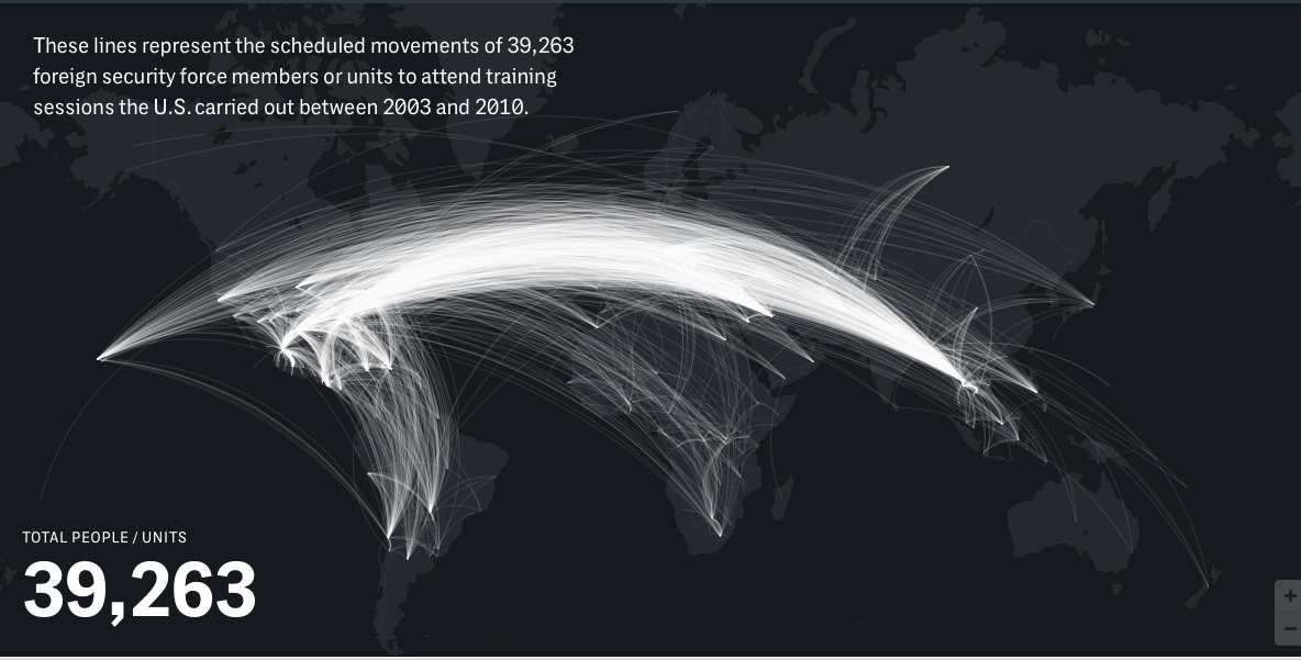
This map is the most comprehensive depiction in civilian circles of U.S. military and government antiterrorist actions overseas in the past two years. To develop it, my colleagues and I at Brown University’s Costs of War Project at the Watson Institute for International and Public Affairs, along with Smithsonian magazine, combed through U.S. and foreign government sources, published and unpublished reports, military websites and geographical databases; we contacted foreign embassies in the U.S. and the military’s United States Africa Command; and we conducted interviews with journalists, academics and others. We found that, contrary to what most Americans believe, the war on terror is not winding down—it has spread to more than 40 percent of the world’s countries. The war isn’t being waged by the military alone, which has spent $1.9 trillion fighting terrorism since 2001. The State Department has spent $127 billion in the last 17 years to train police, military and border patrol agents in many countries and to develop antiterrorism education programs, among other activities.

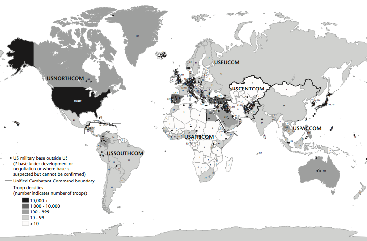
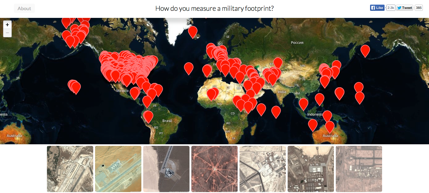
This map can usefully be compared with David Vine‘s heroic cartography of US military bases (from 2015) which I discuss in detail here.

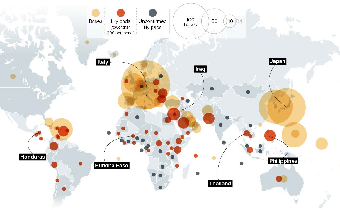
If you want more detail on US deployments in Africa, then the indefatigable Nick Turse has an excellent survey at the Intercept here.

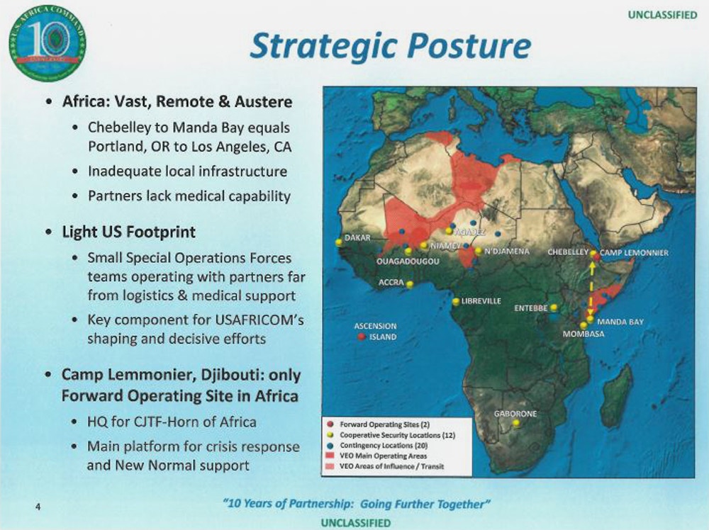
As Nick notes, the ‘light footprint’ claimed for US Africa Command (AFRICOM) in briefing documents (above) resolves into a vast network of bases across the continent.

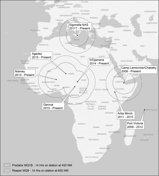
You can find more in Adam Moore and James Walker‘s “Tracing the US military’s presence in Africa” in Geopolitics 21 (2016) 686-716 (also via ssrn here)  The essay includes this map of drone bases and operational ranges which usefully makes the point that the US military presence is scarcely confined to the pinprick presence of those bases but radiates from each of them:

On which note, I also recommend Jolle Demmers and Lauren Gold, ‘An assemblage approach to liquid warfare: AFRICOM and the ‘hunt’ for Joseph Kony’, Security Dialogue 49 (5) (2018) 364-81.

Offshoring

Offshoring military violence

I’ve written about US military bases overseas before – via David Vine‘s brilliant, painstaking work (see here and here) – but a new study from The Intercept has revealed another, much less visible geography of ‘offshoring’ military violence: the training of foreign military, police and security personnel by the United States.

soaI imagine most readers will know of the infamous ‘School of the Americas‘ at Fort Benning (since renamed the ‘Western Hemisphere Institute for Security Cooperation’) – if you don’t, read Juanita Sundberg in Antipode 39 (1) (2007) 144-66 or Sara Koopman in Antipode 40 (5) (2008) 825-47 on transnational protests against the School –  but the network of global military and paramilitary collaboration is much more extensive:

The data show training at no fewer than 471 locations in 120 countries — on every continent but Antarctica — involving, on the U.S. side, 150 defense agencies, civilian agencies, armed forces colleges, defense training centers, military units, private companies, and NGOs, as well as the National Guard forces of five states. Despite the fact that the Department of Defense alone has poured some $122 billion into such programs since 9/11, the breadth and content of this training network remain virtually unknown to most Americans.

The contours of this sprawling system were discovered by analyzing 6,176 diplomatic cables that were released by WikiLeaks in 2010 and 2011. While the scope of the training network may come as a surprise, the most astounding fact may be that it is even larger than the available data show, because the WikiLeaks cables are not comprehensive. They contain, for example, little information on training efforts in Colombia, the single-largest recipient of U.S. training covered by the human rights vetting process that produced these records. Other large recipients of U.S. security assistance, such as Pakistan, are vastly underrepresented in the cables for reasons that remain unclear.

My image at the top of this post is just a screenshot and you really should visit the original because it’s an interactive and you can use your mouse to get much more detail.

Base Nation

VINE Base Nation

Matt Farish‘s perceptive view of David Vine‘s BaseNation – ‘a distressing and tremendously helpful resource for grappling with the global geography of the American armed forces’ (see also here, the map here [also shown above] and the interactive map here) – is up at the LA Review of Books here.

Base-Nation1-243x366The Baseworld that was pieced together during and after World War II undoubtedly represented “a qualitative and quantitative shift,” but it is noteworthy that a place like Fort Leavenworth, Kansas, once dubbed the “western edge of civilization,” is today both a heritage landscape and an active Army facility, including, of course, the military’s most prominent prison. As historians have noted, the movement of men and motifs from the “Indian Wars” to overseas conflicts like the Philippine-American War (1899–1902) was direct. “Now that the continent is subdued,” the California-based Overland Monthly announced in 1898, “we are looking for fresh worlds to conquer.”

In the 21st century, the perverse demand for “total defense” has produced an increasingly diverse roster of base types, from Germany’s Kaiserslautern Military Community (including the massive Ramstein Air Base), home to an 840,000-square-foot mall, to the small, often secretive “lily pads” that typify the Pentagon’s role “in at least forty-nine of the fifty-four African countries. It may be operating in every single one.” By limiting the number of troops in place — sometimes replacing them with “pre-positioned” weapons and matériel — and encouraging closer ties with other national militaries, lily pads present a different sort of challenge for opponents of military presence.

But Matt – I think properly refuses the distinction between ‘domestic’ and ‘extraterritorial’:

Vine’s decision to focus almost exclusively on “extraterritorial” sites is practical, but it is also political, even as the division implied by this word is unsustainable. The benefits of its retention seem meager: it allows Vine to advocate for a return of “troops and base spending back to the United States,” “stemming the leakage of money out of the U.S. economy and ensuring that economic spillover effects remain at home.” Despite the stupendous number of dollars at stake — tens if not hundreds of billions, annually — I still wonder if Vine’s heart is really in this argument, or if he would prefer to emphasize the “twenty-first century form of colonialism” he documents in places like Guam, and the restitutions that might result from demilitarization. But even on this charge, he follows the same path, claiming that the condition of Guam or Puerto Rico hinders “our country’s ability to be a model for democracy.” For followers of popular political speech, this is familiar prose. But it is still a fictional aspiration, all the more frustrating because it seems to be the result of authorial or editorial pragmatism. It falls apart as soon as we consider varieties of ongoing military colonialism and environmental injustice in the American Southwest, for instance.

David has promised to donate all proceeds from Base Nation ‘to nonprofit organizations serving military veterans, their families, and other victims of war and violence.’

Base lines and military projections

David Vine has updated his map of the global footprint of the US military over at Politico.

VINE US military bases

I used an early version for my ‘War and Peace’ essay (DOWNLOADS tab), and that map – like this one – was drawn primarily from the annual Base Structure Report, a summary of the US military’s ‘real property inventory’ (all sites owned and managed by the Pentagon).  It’s an unwieldy document which uses a high threshold to filter inclusion:

To qualify for individual entry in the BSR, a DoD site located in the United States must be larger than 10 acres AND have a Plant Replacement Value (PRV) greater than $10 million. If the site is located in a foreign country, it must be larger than 10 acres OR have a PRV greater than $10 million to be shown as a separate entry. Sites that do not meet these criteria are aggregated as an “Other” location within each state or country.

Iraq doesn’t appear in these tabulations – though it is shown on the map – yet the continuing US involvement in the conflict there and across the all-but-erased border in Syria has surely extended its footprint.  As David notes,

‘There were 505 bases at the U.S. occupation’s height, but the Iraqi parliament rejected the Pentagon’s wish to keep 58 “enduring” bases after the 2011 withdrawal. U.S. forces have occupied at least five bases since 2014 and are considering more installations.’

Afghanistan is absent too: ‘By the end of 2014 … the U.S. military will have closed, deconstructed, or vacated most of what were once around 800 military installations, ranging from small checkpoints to larger combat outposts to city-sized bases.’  But the US military retains a significant presence there, and its drones are still based there to support continuing military operations and to attack targets across the border in Pakistan.

There are also strategic omissions.  There’s no mention in the Base Structure Report of Al Udeid Air Base in Qatar, for example, which is the location of US Central Command’s Combined Air and Operations Center.

(You can find more from David on the history of America’s ‘infrastructure for war’ in the Middle East here and on its ‘lily-pad’ strategy here).

There are all sorts of issues involved in measuring a ‘military footprint’ – see my post here and Josh Begley here (who works from the previous year’s Base Structure Report for FY 2013 to produce a radically different visualization) – but for all its uncertainties, David’s map is a sobering snapshot, and he relies on supplementary sources to conclude:

Despite recently closing hundreds of bases in Iraq and Afghanistan, the United States still maintains nearly 800 military bases in more than 70 countries and territories abroad—from giant “Little Americas” to small radar facilities. Britain, France and Russia, by contrast, have about 30 foreign bases combined.

By my calculation, maintaining bases and troops overseas cost $85 to $100 billion in fiscal year 2014; the total with bases and troops in warzones is $160 to $200 billion.

VINE Base Nation

When I first contacted David, his original map formed part of his scorching investigation into Diego Garcia: Island of Shame: the secret history of the US military base on the island of Diego Garcia (Princeton, 2009; paperback 2011: all royalties went to the Chagossians); the new version forms part of an even more ambitious project, Base Nation: how US military bases abroad harm America and the world (Metropolitan Books, 2015):

American military bases encircle the globe. More than two decades after the end of the Cold War, the U.S. still stations its troops at nearly a thousand locations in foreign lands. These bases are usually taken for granted or overlooked entirely, a little-noticed part of the Pentagon’s vast operations. But in an eye-opening account, Base Nation shows that the worldwide network of bases brings with it a panoply of ills–and actually makes the nation less safe in the long run.

As David Vine demonstrates, the overseas bases raise geopolitical tensions and provoke widespread antipathy towards the United States. They also undermine American democratic ideals, pushing the U.S. into partnerships with dictators and perpetuating a system of second-class citizenship in territories like Guam. They breed sexual violence, destroy the environment, and damage local economies. And their financial cost is staggering: though the Pentagon underplays the numbers, Vine’s accounting proves that the bill approaches $100 billion per year.

For many decades, the need for overseas bases has been a quasi-religious dictum of U.S. foreign policy. But in recent years, a bipartisan coalition has finally started to question this conventional wisdom. With the U.S. withdrawing from Afghanistan and ending thirteen years of war, there is no better time to re-examine the tenets of our military strategy. Base Nation is an essential contribution to that debate.

There is a long history of struggles against the presence of US military bases overseas – Catherine Lutz‘s edited collection, The bases of empire: the global struggle against US military posts (New York University Press, 2009) remains an indispensable starting-point.

Of course, the US military is also omnipresent in the United States, with installations in all 50 states and seven territories.  The Base Structure Report includes this summary:

DoD sites JPEG

And these bases have brought their own problems and spawned their own protests too.


Eyes in the sky, boots on the ground

When I was working on my ‘War and peace’ essay (Trans Inst Br Geogr 35 (2010) 154–186; DOWNLOADS TAB) – which will appear, in radically revised and extended form, in The everywhere war – I included this map of US military bases outside the continental United States, based on David Vine‘s Island of shame: The Secret History of the U.S. Military Base on Diego Garcia (2009), which was in turn derived from the Pentagon’s 2007 Base Structure Report:

US military bases

Various other versions are available around the web, but now – inspired in part by Trevor Paglen‘s Blank Spots on the Map – a new project by Josh Begley (of Dronestream fame) has worked from the 2013 Base Structure Report to produce a new base map supplemented by aerial/satellite imagery of more than 640 US military bases around the world.

It’s still a minimalist accounting, but the lacunae are produced not only by the secret installations that are systematically excluded from the Pentagon’s public accounting of what it calls its ‘real property’  – if only there could be a listing of its surreal property too (which is where Trevor comes in) – but also by the database’s predisposition towards permanence (of sorts).  You’ll see what I mean if you zoom in on Afghanistan: the main Forward Operating Bases are there but none of the firebases and combat outposts scattered across the landscape.  Still, even in this appropriately skeletal form, it’s a vivid reminder of the boots firmly planted on other people’s ground.

BEGLEY How do you measure a military footprint?

Josh includes a sharp-eyed commentary on the differences between images of the same site on different commercial platforms, and concludes his opening essay, ‘How do you measure a military footprint?’ like this:

Taken as a whole, I’d like to think this collection can begin to approximate the archipelago of militarized space often understood as empire. But I’m hesitant to say that. It seems to me that empire involves more than pushpins on a map. It is made up of human activity — a network of situated practices that preclude constellational thinking and sculpt geographies in their own image.

I’m not sure aerial photography can get at that complexity. But perhaps an outline of this footprint– of runways and bases and banal-looking buildings — might begin to chip away at the bumper-sticker simplicity much political discourse about the military-industrial complex gets reduced to.

A friend recently sent me this passage from Ananya Roy [‘Praxis in the time of Empire’, Planning Theory 5 (1) (2006) 7-29] that I’ve come to like quite a bit:

“The time of empire is war and destruction, but it is also creation, beauty, and renewal. The apparatus of empire is the military, but it is also architecture, planning, and humanitarian aid. The mandate of empire is to annihilate, but it is also to preserve, rebuild, and protect. Empire rules through coercion and violence, but it also rules through consent and culture.”

HAFFNER The view from aboveTwo quick comments.  First, if you want more on what aerial photography can get at – and in particular its historical formation as an indispensable vector of modern war – try Terrence Finnegan‘s Shooting the Front: Allied aerial reconnaissance in the First World War (2011), which has already established itself as a classic, or if you prefer a more theoretically informed survey, Jeanne Heffner‘s  The view from above: the science of social space (2013), especially Chapter 3, ‘The opportunity of war’.  War doesn’t loom as large as you’d think in Denis Cosgrove and William Fox‘s Photography and flight (2010), but you’ll also find interesting ideas in Paul Virilio‘s perceptive War and cinema.  On satellite imagery, the most relevant essay for the background to this project is probably Chris Perkins and Martin Dodge, ‘Satellite imagery and the spectacle of secret spaces‘, Geoforum 40 (4) (2009) 546-60.  The different platforms that Josh discusses (Google Earth and Bing) derive much of their imagery from DigitalGlobe: for an update on its new super-high res WorldView-3 (and its restriction to the US military and security apparatus), see Neal Ungerleider, ‘Google Earth, foreign wars and the future of satellite imagery’ here.  Among her many important essays, Lisa Parks‘ ‘Zeroing in: overhead imagery, infrastructure ruins and datalands in Iraq and Afghanistan’ is an indispensable kick-start for thinking about satellite imagery and military violence, and you can find it in Jeremy Packer and Stephen Crofts Wiley (ed) Communication matters (2013) and in Nicholas Mirzoeff‘s Visual culture reader (3rd edition, 2013).  One of my favourite essays – and the one that got me started on the intimate connections between political technologies of vision and military violence an age ago – is Chad Harris‘s ‘The omniscient eye: satellite imagery, “battlespace awareness” and the structures of the imperial gaze’, open access at Surveillance and society 4 (1/2) (2006) here.

Second, it is indeed important to think through all the ways in which the US military/security presence reaches beyond these pinpricks on the map.  These are bases for more extensive military operations, obviously, but there is also the roving US presence in outer space, air and ocean – and cyberspace – that is necessarily absent from these static arrays.  In addition – and there must be many other add-ons –  the US is hardening its borders in a transnational space, confirming the argument made explicit in the 9/11 Commission report: ‘the American homeland is the planet’.  Deb Cowen‘s seminal essay on ‘A geography of logistics’ is indispensable here, and Todd Miller provides a recent vignette on what he calls Border Patrol International here.

Oh – one more thing.  Josh’s new project has been widely advertised – from Gizmodo through the Huffington Post to the Daily Mail (really) – but if you want to see whether you’re in step with other posters and the trolls, look at the comments sections.  Sobering.  Gizmodo is particularly revealing/depressing.