Seeing machines


graham-drone-cover

The Transnational Institute has published a glossy version of a chapter from Steve Graham‘s Vertical – called Drone: Robot Imperium, you can download it here (open access).  Not sure about either of the terms in the subtitle, but it’s a good read and richly illustrated.

Steve includes a discussion of the use of drones to patrol the US-Mexico border, and Josh Begley has published a suggestive account of the role of drones but also other ‘seeing machines’ in visualizing the border.

One way the border is performed — particularly the southern border of the United States — can be understood through the lens of data collection. In the border region, along the Rio Grande and westward through the desert Southwest, Customs and Border Protection (CBP) deploys radar blimps, drones, fixed-wing aircraft, helicopters, seismic sensors, ground radar, face recognition software, license-plate readers, and high-definition infrared video cameras. Increasingly, they all feed data back into something called “The Big Pipe.”

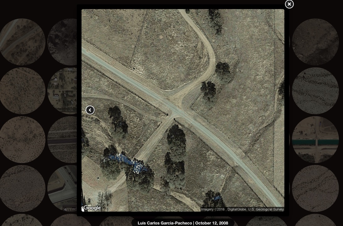
Josh downloaded 20,000 satellite images of the border, stitched them together, and then worked with Laura Poitras and her team at Field of Vision to produce a short film – Best of Luck with the Wall – that traverses the entire length of the border (1, 954 miles) in six minutes:

The southern border is a space that has been almost entirely reduced to metaphor. It is not even a geography. Part of my intention with this film is to insist on that geography.

By focusing on the physical landscape, I hope viewers might gain a sense of the enormity of it all, and perhaps imagine what it would mean to be a political subject of that terrain.

begley-fatal-migrations-1

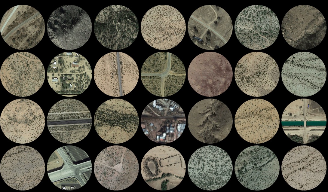
If you too wonder about that last sentence and its latent bio-physicality – and there is of course a rich stream of work on the bodies that seek to cross that border – then you might visit another of Josh’s projects, Fatal Migrations, 2011-2016 (see above and below).

begley-fatal-migrations-2

There’s an interview with Josh that, among other things, links these projects with his previous work.

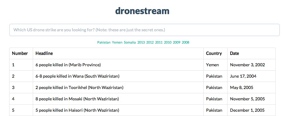
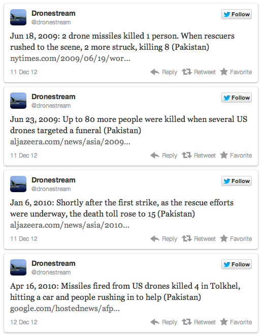
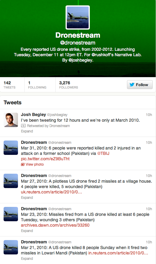
I have a couple of projects that are smartphone centered. One of them is about mapping the geography of places around the world where the CIA carries out drone strikes—mostly in Pakistan, Yemen, and Somalia. Another was about looking at the geography of incarceration in the United States—there are more than 5,000 prisons—and trying to map all of them and see them through satellites. I currently have an app that is looking at the geography of police violence in the United States. Most of these apps are about creating a relationship between data and the body, where you can receive a notification every time something unsettling happens. What does that mean for the rest of your day? How do you live with that data—data about people? In some cases the work grows out of these questions, but in other cases the work really is about landscape….

There’s just so much you can never know from looking at satellite imagery. By definition it flattens and distorts things. A lot of folks who fly drones, for instance, think they know a space just from looking at it from above. I firmly reject that idea. The bird’s eye view is never what it means to be on the ground somewhere, or what it means to have meaningful relationships with people on the ground. I feel like I can understand the landscape from 30,000 feet, but it is not the same as spending time in a space.

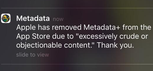
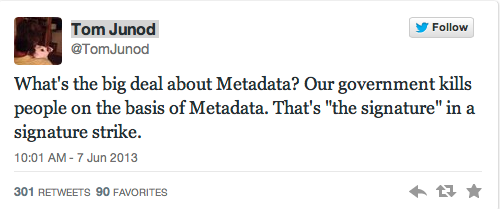
Anjali Nath has also provided a new commentary on one of Josh’s earlier projects, Metadata, that he cites in that interview – ‘Touched from below: on drones, screens and navigation’, Visual Anthropology 29 (3) (2016) 315-30.

It’s part of a special issue on ‘Visual Revolutions in the Middle East’, and as I explore the visual interventions I’ve included in this post I find myself once again thinking of a vital remark by Edward Said:

we-are-also-looking-at-our-observers-001

That’s part of the message behind the #NotaBugSplat image on the cover of Steve’s essay: but what might Said’s remark mean more generally today, faced with the proliferation of these seeing machines?


The Drone Papers

Drone Papers header JPEG

The Intercept has released a new series of documents – not from Edward Snowden – that provide extraordinary details about the Obama administration’s targeted killing operations (especially in Afghanistan, Yemen and Somalia).

I haven’t had a chance to work through them yet – today is taken up with teaching and Eyal Weizman‘s visit for tonight’s Wall Exchange – but I imagine that readers who don’t already have their heads up will welcome a head’s up.

The reports include a considerable number of informative graphics (taken from briefing slides) together with analysis.  Here is the full list:

The Assassination Complex (by Jeremy Scahill)

A visual glossary (by Josh Begley)

The Kill Chain (by Jeremy Scahill)

Find, Fix, Finish (by Jeremy Scahill)

Manhunting in the Hindu Kush (by Ryan Devereaux)

Firing Blind (by Cora Currier and Peter Maass)

The Life and Death of Objective Peckham (by Ryan Gallagher)

Target Africa (by Nick Turse)

More to come when I’ve worked through the reports, slides and analyses.

Under American Skies

I’ll be in Berlin in December for a conversation with James Bridle about drone wars and related issues, and I’m already looking forward to it since I’m a great admirer of his work. I particularly admire the way in which he challenges so many of our assumptions about ‘looking’ through his presentations about militarised vision and violence, and I’ve noted before the filiations between his various projects and Josh Begley‘s.

Tomas van HoutryveSo I was interested to read about photographer Tomas van Houtryves (right) project Blue Sky Days.  He begins with an arresting observation with which both James and Josh would be only too familiar:

‘Although a huge amount of [full motion video] footage has been collected [by US drones], the program is classified, and few people have ever seen images of the drone war and its casualties. This seems like a paradox in our thoroughly media-connected age. How can America be involved in a decade-long war where the sky is buzzing with cameras, and yet the public remains totally in the dark?’

But his response to the question is distinctly different: he repatriates the drone wars from Pakistan to the United States (here the most appropriate comparison is with Omar Fast‘s 5,000 Feet is the Best).

Tomas van Houtryve 1

To do so, Tomas travelled across America with a small quadcopter drone bought from Amazon.com attached to his camera.  His concept was simple, Rena Silverman explains in the New York Times:

Take the idea of foreign drone strikes and instead target similar domestic situations, putting them under surveillance using his drone in public spaces. He made a list of hundreds of different strike reports, gleaning as many details about the circumstances…

He rented a black car with tinted windows and placed himself, his drones, his batteries and lists in the car. He spent six weeks in late 2013 averaging between seven and 10 drone flights daily, sleeping in a different town every night. He would pull the car into an empty lot, get out, launch the drone for about five to 10 minutes — about as long as its power lasted — take footage, land the drone, drive away and recharge the batteries while en route to the next location…

He followed his list carefully, trying to imitate “signature strikes,” referring to a May 2012 New York Times article in which some State Department officials complained about the lax criteria for identifying a terrorist “signature.” The joke was that “three guys doing jumping jacks” could be enough suspicious activity for the C.I.A. to conclude it could be a terrorist training camp. In other words, targeting people based on behavior rather than identity.

Tomas van Houtryve 2 copy

He photographed people exercising in Philadelphia, their shadows long and pinned against the grid of a park. He noticed more “signature” behavior while driving through San Francisco, where he encountered a group doing yoga [above]. When Mr. van Houtryve recently printed the image, he asked viewers if they thought the subjects were praying or exercising. It was a toss-up.

Although these images are not quite ‘what drone attacks in America would look like’, as Pete Brook suggested in WIRED – Tomas’s drone was flying much lower (‘only about six stories high’) and these images are pin-point sharp: there’s none of the ambiguity of infra-red heat signatures here – none the less that last sentence really says it all.  Images do not speak for themselves and interpretation counts for everything – which is why, as I’ve repeatedly argued, it matters so much what pilots, sensor operators and image analysts are pre-disposed to see.

It turns out that a particular incident provoked Tomas’s project – the murder of Mamana Bibi at Ghunda Kala in North Waziristan on 24 October 2012, which I described here –  and also gives it its title.

Zubair RehmanIn October 2012, a drone strike in northeast Pakistan killed a 67-year-old woman picking okra outside her house. At a briefing held in 2013 in Washington, DC, the woman’s 13-year-old grandson, Zubair Rehman, spoke to a group of five lawmakers. “I no longer love blue skies,” said Rehman, who was injured by shrapnel in the attack. “In fact, I now prefer gray skies. The drones do not fly when the skies are gray.”

There’s more from Tomas at Harper’s here, which originally co-sponsored the project with the Pulitzer Center, and you can see more of his drone’s eye view images at the National Geographic here.

There’s also a revealing interview conducted by Bard College’s Center for the Study of the Drone here; it contains all sorts of interesting observations, but one in particular resonated.  Asked about the tension between the beauty of his photographic compositions and the horror of what he is seeking to convey, Tomas says this:

‘The base subject that I’m trying to raise awareness about and get people to think about in less abstract terms is the foreign drone war. If you take the time to read through the particular airstrikes, a lot of them are quite horrifying. But on the other hand, as a photographer, I know that beauty is one of the tools that we use to get people to look at a picture. Beauty has a lot of power, so there’s a tension between trying to seduce people with the language of photography, which is beautiful composition, and trying to reveal something that might be uncomfortable or difficult to digest, once people fully grasp it.’

Another of my art icons, elin o’Hara slavick, says something very similar about her mesmerising sequence of aerial images of places bombed by the US, Bomb after bomb (see also Brian Howe‘s discussion here and my own in ‘Doors in to Nowhere’ [DOWNLOADS tab], from which I’ve taken this passage):

‘She adopts an aerial view—the position of the bombers—in order to stage and to subvert the power of aerial mastery. The drawings are made beautiful “to seduce the viewer,” she says, to draw them into the deadly embrace of the image only to have their pleasure disrupted when they take a closer look. “Like an Impressionist or Pointillist painting,” slavick explains, “I wish for the viewer to be captured by the colors and lost in the patterns and then to have their optical pleasure interrupted by the very real dots or bombs that make up the painting.”’

A tart reminder that there are multiple ways of ‘just looking‘.

Eyes in the sky, boots on the ground

When I was working on my ‘War and peace’ essay (Trans Inst Br Geogr 35 (2010) 154–186; DOWNLOADS TAB) – which will appear, in radically revised and extended form, in The everywhere war – I included this map of US military bases outside the continental United States, based on David Vine‘s Island of shame: The Secret History of the U.S. Military Base on Diego Garcia (2009), which was in turn derived from the Pentagon’s 2007 Base Structure Report:

US military bases

Various other versions are available around the web, but now – inspired in part by Trevor Paglen‘s Blank Spots on the Map – a new project by Josh Begley (of Dronestream fame) has worked from the 2013 Base Structure Report to produce a new base map supplemented by aerial/satellite imagery of more than 640 US military bases around the world.

It’s still a minimalist accounting, but the lacunae are produced not only by the secret installations that are systematically excluded from the Pentagon’s public accounting of what it calls its ‘real property’  – if only there could be a listing of its surreal property too (which is where Trevor comes in) – but also by the database’s predisposition towards permanence (of sorts).  You’ll see what I mean if you zoom in on Afghanistan: the main Forward Operating Bases are there but none of the firebases and combat outposts scattered across the landscape.  Still, even in this appropriately skeletal form, it’s a vivid reminder of the boots firmly planted on other people’s ground.

BEGLEY How do you measure a military footprint?

Josh includes a sharp-eyed commentary on the differences between images of the same site on different commercial platforms, and concludes his opening essay, ‘How do you measure a military footprint?’ like this:

Taken as a whole, I’d like to think this collection can begin to approximate the archipelago of militarized space often understood as empire. But I’m hesitant to say that. It seems to me that empire involves more than pushpins on a map. It is made up of human activity — a network of situated practices that preclude constellational thinking and sculpt geographies in their own image.

I’m not sure aerial photography can get at that complexity. But perhaps an outline of this footprint– of runways and bases and banal-looking buildings — might begin to chip away at the bumper-sticker simplicity much political discourse about the military-industrial complex gets reduced to.

A friend recently sent me this passage from Ananya Roy [‘Praxis in the time of Empire’, Planning Theory 5 (1) (2006) 7-29] that I’ve come to like quite a bit:

“The time of empire is war and destruction, but it is also creation, beauty, and renewal. The apparatus of empire is the military, but it is also architecture, planning, and humanitarian aid. The mandate of empire is to annihilate, but it is also to preserve, rebuild, and protect. Empire rules through coercion and violence, but it also rules through consent and culture.”

HAFFNER The view from aboveTwo quick comments.  First, if you want more on what aerial photography can get at – and in particular its historical formation as an indispensable vector of modern war – try Terrence Finnegan‘s Shooting the Front: Allied aerial reconnaissance in the First World War (2011), which has already established itself as a classic, or if you prefer a more theoretically informed survey, Jeanne Heffner‘s  The view from above: the science of social space (2013), especially Chapter 3, ‘The opportunity of war’.  War doesn’t loom as large as you’d think in Denis Cosgrove and William Fox‘s Photography and flight (2010), but you’ll also find interesting ideas in Paul Virilio‘s perceptive War and cinema.  On satellite imagery, the most relevant essay for the background to this project is probably Chris Perkins and Martin Dodge, ‘Satellite imagery and the spectacle of secret spaces‘, Geoforum 40 (4) (2009) 546-60.  The different platforms that Josh discusses (Google Earth and Bing) derive much of their imagery from DigitalGlobe: for an update on its new super-high res WorldView-3 (and its restriction to the US military and security apparatus), see Neal Ungerleider, ‘Google Earth, foreign wars and the future of satellite imagery’ here.  Among her many important essays, Lisa Parks‘ ‘Zeroing in: overhead imagery, infrastructure ruins and datalands in Iraq and Afghanistan’ is an indispensable kick-start for thinking about satellite imagery and military violence, and you can find it in Jeremy Packer and Stephen Crofts Wiley (ed) Communication matters (2013) and in Nicholas Mirzoeff‘s Visual culture reader (3rd edition, 2013).  One of my favourite essays – and the one that got me started on the intimate connections between political technologies of vision and military violence an age ago – is Chad Harris‘s ‘The omniscient eye: satellite imagery, “battlespace awareness” and the structures of the imperial gaze’, open access at Surveillance and society 4 (1/2) (2006) here.

Second, it is indeed important to think through all the ways in which the US military/security presence reaches beyond these pinpricks on the map.  These are bases for more extensive military operations, obviously, but there is also the roving US presence in outer space, air and ocean – and cyberspace – that is necessarily absent from these static arrays.  In addition – and there must be many other add-ons –  the US is hardening its borders in a transnational space, confirming the argument made explicit in the 9/11 Commission report: ‘the American homeland is the planet’.  Deb Cowen‘s seminal essay on ‘A geography of logistics’ is indispensable here, and Todd Miller provides a recent vignette on what he calls Border Patrol International here.

Oh – one more thing.  Josh’s new project has been widely advertised – from Gizmodo through the Huffington Post to the Daily Mail (really) – but if you want to see whether you’re in step with other posters and the trolls, look at the comments sections.  Sobering.  Gizmodo is particularly revealing/depressing.

Boundless Informant and the everyware war

As part of my presentation on “Drones and the everywhere war” at York, I decided to unpack this extraordinary claim made by John Nagl, one of the architects of the US military’s revised counterinsurgency doctrine:

We’re getting so good at various electronic means of identifying, tracking, locating members of the insurgency that we’re able to employ this extraordinary machine, an almost industrial-scale counterterrorism killing machine that has been able to pick out and take off the battlefield not just the top level al Qaeda-level insurgents, but also increasingly is being used to target mid-level insurgents.

It’s a remark I’ve discussed several times before.  Nagl’s ‘killing machine’ is not limited to drone strikes, of course, but subsumes the ‘night raids’  and other Special Forces operations detailed in Jeremy Scahill‘s Dirty Wars.  But at York I wanted to explore how those ‘electronic means of identifying, tracking and locating’ fed into drone strikes in Pakistan: and, thanks to Edward Snowden and Glenn Greenwald, I was able to get much closer to the belly of the beast.

Drones+ app

I’d started the presentation with a riff on Josh Begley‘s attempt to persuade Apple to include his Drones+ app in the App store.  Apple decided, for several contradictory and spurious reasons, to reject the app, and at his thesis defence Josh asked:

 ‘Do we really want to be as connected to our foreign policy as we are to our smart phones… Do we really want these things to be the site of how we experience remote war?’

Apple’s answer was ‘no’, clearly, but it turns out that others are intimately connected to drone strikes through their phones and e-mails, and it was this that I fastened on.

Josh, undeterred by Apple, went on to launch the Dronestream platform, from which he tweeted details of every known US drone strike.  I combined one of Josh’s tweets for 1 October 2012 with a version of James Bridle‘s Dronestagram, which uses Instagram to post images of the location of drone strikes (I say ‘a version’ because Dronestagram was launched too late for this particular strike, so this is a mock-up; in any case, it’s difficult to pinpoint the locations from available reports with much precision, but the details for this strike are available via the Bureau of Investigative Journalism, as the second slide below shows):

1 October 2012 Dronestream and Dronestagram

Bureau of Investigative Journalism 1 October 2012 strike

We now know that this strike was made possible as a result of interceptions made by the National Security Agency’s Counter-Terrorism Mission-Aligned Cell (CT-MAC).  Writing in the Washington Post on 16 October 2013 Greg Miller, Julie Tait and Barton Gellman explained how this strike had targeted Hassan Ghul:

Hassan Ghul NSA intercepts

Not quite ‘any doubt’; as they went on to note, ‘Although the attack was aimed at “an individual believed to be” the correct target, the outcome wasn’t certain until later, when “through SIGINT [signals intelligence] it was confirmed that Hassan Ghul was killed.”‘

So how did the intercept work?  Not surprisingly, we don’t know for sure; but the map below of NSA’s ‘Boundless Informant‘ – another dimension of what I’ve been calling ‘the everywhere war’ – offers some clues.  I’ve taken it from a report in the Guardian by Glenn Greenwald and Ewen MacAskill:

Boundless Informant March 2013 heat map

This is six months later, but it shows that Pakistan was, after Iran, the major focus of NSA’s surveillance and data mining operations (Miller and his colleagues had noted that “NSA threw the kitchen sink at FATA’, the Federally Administered Tribal Areas).  It would be wrong to assume that the targeted killing of Ghul was the result of a simple hack into hotmail, and the Post report details the multiple methods used by NSA.

Still, the geography of covert surveillance shown on the map is revealing.  Yesterday Greenwald returned to Boundless Informant and rebutted the charge that he had misinterpreted the meaning of this and other slides, and in doing so quoted from NSA’s own explanation of the system:

BOUNDLESSINFORMANT is a GAO [Global Access Operations, a branch of the NSA] prototype tool for a self-documenting SIGINT system. . . BOUNDLESSINFORMANT provides the ability to dynamically describe GAO’s collection capabilities (through metadata record counts) with no human intervention and graphically display the information in a map view, bar chart, or simple table. . . .
By extracting information from every DNI and DNR metadata record, the tool is able to create a near real-time snapshot of GAO’s collection capability at any given moment. The tool allows users to select a country on a map and view the metadata volume and select details about the collection against that country. The tool also allows users to view high level metrics by organization and then drill down to a more actionable level – down to the program and cover term.

It’s not too difficult to connect the dots and draw two more general conclusions.  The first is that this is another, darker dimension to the ‘code/space’ and ‘everyware’ discussed in such impressive detail by Rob Kitchen and Martin Dodge:

Everyware war

My slide is just short-hand, of course, but you can see where I’m going, I hope – and, as we know from this week’s harrowing testimony on Capitol Hill about the murder of Mamana Bibi in Waziristan and Amnesty International’s report, Will I Be Next?, these operations and their algorithms work to turn ‘everyday life’ into everyday death.  So I’ll be thinking more carefully about code/space and its implication in the individuation of later modern war, paying closer attention to the technical production of ‘individuals’ as artefacts and algorithms as well as the production of the space of the target: more to come.

The second general conclusion I leave to Peter Scheer, who provides a more refined (and critical) gloss on John Nagl’s comment with which I began:

SCHEER Connecting the dots

I’m incorporating these and other developments into the revised and extended version of “Moving targets and violent geographies” which will appear in The everywhere war, but I hope this bare-bones account (and that first draft, available under the DOWNLOADS tab) shows that my posts are more connected than they must sometimes appear…  The slides were pulled together on the day I gave the presentation, so forgive any rough edges.

Dead streaming

Readers who have followed Josh Begley‘s Dronestream project – which I commented on here  – will be interested in this video of his graduate thesis presentation at NYU:

It’s a tour de force in under 15 minutes.  Josh begins with a rapid-fire overview of over 480 more or less covert US drone strikes in 10 years killing more than 4,700 people.  ‘What can our relationship be with this story?’ he asks.

His first attempt at finding an answer was the Drones+ app that was intended to send a notification to your iPhone every time news broke of a drone strike in Pakistan, Yemen or Somalia.  Like James Bridle‘s Dronestagram (which enabled satellite images of the sites of remote strikes to be viewed on an iPhone), it was a way of projecting the remoteness of the strikes into the intimacy of our own life-worlds.  But  Drones+ was more demanding precisely because its episodic notifications made those strikes more insistent, more interruptive.  Hence Josh’s key question:

‘Do we really want to be as connected to our foreign policy as we are to our smart phones?  … which are these increasingly intimate devices, the places where we share pictures of or loved ones and communicate with our friends, the things that we pull out of our pockets when we’re lost and which auto-magically put us at the center of the map……  Do we really want these things to be the site of how we experience remote war?’

Apple’s answer was no, as he ruefully acknowledges, though I suspect that would also be the answer of many others too: that, after all, is the appeal of remote wars to those who orchestrate them.  Out of sight, out of mind: which is precisely why there is also something ‘auto-magical’ about Josh’s determination to ‘détourne‘ these remote technologies like this.

Josh’s next step was to use a Twitter account to start to tweet every recorded drone strike, which eventually morphed (via the aggregations of the Bureau of Investigative Journalism) into Dronestream: or, more accurately, Dronestre.am.

Dronestre.am

This is a publicly accessible API (Application Programming Interface) that enables the data set to be interrogated and visualized in multiple ways (and if you want a simple account of working with the API, check out Felix Haas here):

dronestream

Josh credits Trevor Paglen‘s ‘spatial analysis’ and his ongoing attempts to outline the Blank Spots on the Map as a particular inspiration for his work.  What he has sought to do, by extension, is to map ‘the blank spots in the data’: to recover what he calls ‘the negative space that these drone strikes take up’, and so enable complex stories and ordinary voices to emerge out of the swirl of Big Data.  In doing so, he argues that it becomes possible to ‘speak back’ to the drones and to the masters of dirty wars that control them, in effect artfully turning this latest version of techno-war against itself.

The trick now is to fill out these ‘blank spots on the map’, to recover the insistently human geographies that are devastated by these air strikes and the threat of more to come, so that we can overturn both the ‘face-less’ and the ‘place-less’ narrative of the covert war machine.  It thrives on being both out of sight and out of site, and Josh’s research is invaluable in reminding us that the virtual technologies that make its depredations possible are also acutely material in their form and in their effects.

The military and the mob

Double Tap streamMichael Kelley notes that Josh Begley‘s tweeted enumeration of US drone strikes in Pakistan, Yemen and Somalia at Dronestream confirms the vile ‘double-tap‘ strategy in which a first strike is rapidly followed by a second targeting rescuers.  As Kelley notes, ‘A 2007 report by the Homeland Security Institute called double taps a “favorite tactic of Hamas” and the FBI considers it a tactic employed by terrorists.’

The militarised practice has been widely reported – not least in Staford/NYU’s Living under Drones – but Begley’s cascade of tweets provides a powerful statement of its relentless rhythm.  In September Mirza Shahzad Akbar, a Pakistani lawyer who represents victims of the attacks, told Britain’s Independent newspaper:

“These strikes are becoming much more common…  In the past it used to be a one-off, every now and then. Now almost every other attack is a double tap. There is no justification for it.”

Far from any justification, the UN Special Rapporteur on Extrajudicial Killings argues that such attacks constitute war crimes.  In fact, as Gwynne Dyer points out,

“DOUBLE TAP” IS what mobsters do when they put somebody down. One bullet in the heart, one in the head. That way they stay down. It’s practically standard operating procedure among hitmen.

Street gangs of Baghdad.001

It’s not so long ago that the Pentagon was alarmed at the presence of members of US street gangs among its soldiers patrolling the streets of Baghdad (see Frank Main, ‘Gangs claim their turf in Iraq’, Chicago Sun-Times 1 May 2006).  It’s high time the US took a look at mobsters patrolling the skies too.

Thanks to my good friend Oliver Belcher for the original link.

The twitter of drones

BAFANA Tweet Drone strike in YemenBack in May the Bureau of Investigative Journalism described how local activists were using Twitter and other social media platforms to spread the news of US drone strikes in Yemen.  Haykal Bafana, a lawyer living in San’a, the capital of Yemen, kept up a barrage of tweets recording the ‘covert’ strikes in near real-time, which were then amplified through Facebook and micro-news platforms in the region. You can follow him here.

Haykal Bafana

This is all of a piece with the incorporation of social media into the conduct of late modern war that was evident during Israel’s recent attack on Gaza and, as Noel Sharkey told the Bureau,

‘It is incredible how the same type of technology used by the CIA to kill people with drones in the Yemen, is empowering the Yemenis to tweet the attacks as they are happening. They can send us all pictures and bring us closer to the horror they are experiencing. Technology in the small may eventually bring down the over-use of military technology in the large.’

Josh BegleyDrone strikes are certainly now being made visible across a range of social media platforms, and now comes news – from the wonderful Jorge Amigo – that Josh Begley (whose Drones+ app was serially rejected by Apple) has started tweeting what Jake Heller calls ‘the entire history of US drone strikes’ in Pakistan, Yemen and Somalia as part of a graduate class at NYU, Narrative Lab, which focuses on ‘the impact of interactivity and technology on traditional narrative structure’.  Begley told Heller that, for him, ‘it’s about the way stories are told on new social-media platforms.’

Dronestream

How complete the data series can be is an open question – and the rhetorical impact would be even more devastating if Afghanistan were included – but as you can see from my screen grab above Begley, who started at noon on Tuesday 11 December, tweeted that after twelve hours ‘we’re only at March 2010’…  Follow him at Dronestream here.  And, as Connor Simpson at the Atlantic Wire commented, ‘if this project doesn’t merit an A, we would love to see one that does.’