Landscapes of intervention

An excellent new edition of Middle East Report (290) on The New Landscape of Intervention; full download details here.

The concept of intervention brings to mind foreign military actions that violate a sovereign jurisdiction. This issue of Middle East Report identifies other, increasingly prevalent, ways in which the lives of people in the Middle East are being shaped by forces beyond their borders. In a context of increasing US retrenchment and neoliberal globalization, powerful states and transnational actors intervene across the region in a variety ways—under the guise of humanitarian assistance, democracy promotion or border security—as well as through new methods like urban planning, infrastructure development, crisis research and health deprivation—what might also be called biopolitical interventions. Even as the 2000’s saw the return of traditional forms of imperial intervention—with the US deployment of military forces in Afghanistan and Iraq in pursuit of a quixotic and unwinnable war on terror—there are increasingly new forms of intervention that must be understood, assessed and mapped.

Contents:

The New Landscape of Intervention – The Editors
The Globalized Unmaking of the Libyan State – Jacob Mundy
Iraqibacter and the Pathologies of Intervention – Omar Dewachi
The Shifting Contours of US Power and Intervention in Palestine – Lisa Bhungalia, Jeannette Greven, Tahani Mustafa
Urban Interventions for the Wars Yet to Come – Hiba Bou Akar
The Palestinian McCity in the Neoliberal Era – Sami Tayeb
Humanitarian Crisis Research as Intervention – Sarah E. Parkinson
The UAE and the Infrastructure of Intervention – Rafeef Ziadah
Israel’s Permanent Siege of Gaza – Ron Smith
Border Regimes and the New Global Apartheid – Catherine Besteman

Footprints of War


When I was working on my essay on ‘The natures of war’ (DOWNLOADS tab), I was surprised at how few sustained discussions of ‘nature’ as a medium through which military violence is conducted – though there were of course countless, vital discussions of ‘nature’ as a commodity bank that triggers so-called resource wars – so when it came to the section on Vietnam I learned much from David Biggs‘ brilliant account Quagmire: Nation-Building and Nature in the Mekong Delta (2011).  It deservedly won the George Perkins Marsh Prize for the best book in environmental history.

(You can find an illustrated version of the section of ‘Natures’ on Vietnam here and here, and some of my other work on the militarization of nature in Vietnam here and here).

David now has a new book, Footprints of War: militarized landscapes in Vietnam, due from the University of Washington Press at the end of this year,

When American forces arrived in Vietnam, they found themselves embedded in historic village and frontier spaces already shaped by many past conflicts. American bases and bombing targets followed spatial and political logics influenced by the footprints of past wars in central Vietnam. The militarized landscapes here, like many in the world?s historic conflict zones, continue to shape post-war land-use politics.

Footprints of War traces the long history of conflict-produced spaces in Vietnam, beginning with early modern wars and the French colonial invasion in 1885 and continuing through the collapse of the Saigon government in 1975. The result is a richly textured history of militarized landscapes that reveals the spatial logic of key battles such as the Tet Offensive.

Drawing on extensive archival work and years of interviews and fieldwork in the hills and villages around the city of Hue to illuminate war’s footprints, David Biggs also integrates historical Geographic Information Systems (GIS) data, using aerial, high-altitude, and satellite imagery to render otherwise placeless sites into living, multidimensional spaces. This personal and multilayered approach yields an innovative history of the lasting traces of war in Vietnam and a model for understanding other militarized landscapes.

The pre-publication reviews confirm the importance of Footprints:

“David Biggs’s second major book on the social and environmental history of modern Vietnam. His nuanced use of Vietnamese-language publications and his extensive interviews with local people are outstanding. He tells a compelling story in fluent, vivid, and even lyrical prose, expressing compassionate insight into both society and ecosystem.”
-Richard P. Tucker, University of Michigan

“In this rich and innovative new book, David Biggs considers the spatial dimension of the war in Vietnam, through an examination of the densely layered militarized landscapes around Hu . The result is a gem, a fluid, authoritative, compelling work that shows just how deep, complex, and long-lasting were ‘The Footprints of War.'”
-Fredrik Logevall, author of Embers of War: The Fall of an Empire and the Making of America’s Vietnam

Trauma Geographies online

My Antipode Lecture on Trauma Geographies is now available online via YouTube.

(If you wonder why I’m hunched over my laptop, the microphone was fixed to the podium….).  Since I’m now turning this into an essay, I’d welcome any questions, comments or suggestions.

You can find more details  including open access to a series of related articles – at the Antipode Foundation website here.

Trauma geographies, woundscapes and the clinic

I returned from the RGS/IBG Conference in Cardiff to the start of term (which explains and I hope excuses my silence: I’ve updated my two course outlines for this term, and you can find them under the TEACHING Tab if you are interested; if you have any comments or suggestions I’d be happy to have them).

My next order of business is to turn my Antipode Lecture on “Trauma Geographies” into a text (the video will be online soon, I hope); I’ve already started on the translation, helped by questions and feedback from the presentation, and I’ll post the draft when it’s ready.

The argument moves from medical care and casualty evacuation in Belgium and France, 1914-1918 through Afghanistan 2001-2018 to Syria 2011-2018, and in each case I address both combatants and civilians.  Much of this trades on (and develops) posts that will be familiar to regular readers – and if you’re not the GUIDE tab ought to help direct you to the most relevant ones – but I’ve also returned to my ideas about corpography and used them to flesh out (sic) the concept of a ‘woundscape‘.  I decided to that because one of the themes of the conference was landscape, and the idea of a woundscape seemed to take that debate in a fruitful new direction.  I first encountered it in Jennifer Terry‘s brilliant Attachments to War, and she in turn found it in the work of Gregory Whitehead (particularly Display Wounds).

I’m drawn to the way in which both authors/performers try to coax wounds to speak, to read their violent ruptures of the body, and to transcend the typically narrowly bio-medical discourse that frames them.  At the same time, I don’t want to ignore that scientific framing, not least because it is profoundly performative and has such vital consequences (both physical and affective), so in my rendering a ‘woundscape’ is constituted through the explosive intersection of the military gaze (‘the target’) and the medical gaze (the injured body) but immediately spirals beyond those visual registers – and indeed beyond visuality – to include a range of other senses and sensibilities. A woundscape thus includes the bio-physical, cognitive and affective landscapes in which casualties are created, moved and treated.  The affective envelope that surrounds and invades the injured body is a constant concern; this extends beyond the casualty to a host of other actors – as Omar Dewachi shrewdly observes, when wounds travel they ‘enter new social worlds and multiple histories of violence’ – but I I focus on physical injury (rather than PTSD) because so many accounts of later modern war have represented it as what James Der Derian dubbed ‘virtuous’ war whose seeming remoteness is rendered as at once increasingly virtual, fought on and through screens and algorithms, and at the limit radically, absurdly disembodied. Against this, I’m trying to respond to John Keegan’s dismayed observation that the wounded – he included the dead too – ‘apparently dematerialize as soon as they are struck down…’

So here are the slides from my presentation that summarise my interim propositions about woundscapes, drawn from the three case studies; I’ll be revising and elaborating them as I proceed, but I hope this might start a conversation:

Finally, Omar’s wonderful essay that I cited earlier appeared in MATMedicine, Anthropology, Theory – and I would be remiss not to draw attention to its most recent issue.  The editorial on ‘Clinic and Crisis‘ by Eileen Moyer and Vinh-Kim Nguyen sends me back to the other essay I’m currently trying to finish, on “The Death of the Clinic“, which plainly intersects with ‘Trauma Geographies’:

A common thread runs through the articles of this issue of MAT: the conjoining of clinic and crisis. Here we refer, in the manner of Foucault (1963) to the clinic as both an epistemology (a way of knowing) as well as a material space where the ill seek care. Crises are moments of rupture, where the surface of everyday life splinters to reveal what lies underneath and new dangers can appear; they are also turning points where futures can be grasped and foretold. Moments of social crisis manifest in bodies, and therefore in the clinic. Das’s notion of ‘critical events’, as discussed in Affliction: Health, Disease, and Poverty and also taken up in MAT’s September 2017 issue, furnishes perhaps the most thorough consideration of crisis. As she and others have pointed out, crisis is an everyday reality for many who live in conditions of precarity and existential instability. More generally, the current geopolitical climate and the growing urgency of climate change contribute to the sense of crisis. The clinic is symptomatic of crisis, a place where a state of emergency becomes finally visible.

More soon – and I haven’t forgotten that I need to return to my series of posts on Ghouta and, in particular, to address the issue of medical care and casualty evacuation (or lack of it) there too.

Mass Murder in Slow Motion (I): East Ghouta

This is the first of a series of posts – continuing my discussions of Cities under Siege in Syria here, here and here – that will examine the siege of East Ghouta in detail.

Today I begin with some basic parameters of East Ghouta, and in subsequent posts I’ll focus on three issues: the siege economy and geographies of precarity; military and paramilitary violence, ‘de-escalation’ and the endgame; and – the hinge linking these two and continuing my work on ‘the death of the clinic‘  – medical care under fire.

From paradise to hell on earth

Eastern Ghouta (‘Ghouta Orientale’ on the map from Le Monde above; ‘Damas’ is of course Damascus) has often been extolled as ‘a Garden of Eden’, ‘an earthly paradise’ and an ‘oasis’.  In the fourteenth century Ibn al-Wardi described the Ghouta as ‘the fairest place on earth’:

. . . full of water, flowering trees, and passing birds, with exquisite flowers, wrapped in branches and paradise-like greenery. For eighteen miles, it is nothing but gardens and castles, surrounded by high mountains in every direction, and from these mountains flows water, which forms into several rivers inside the Ghouta.

Before the present wars much of the Ghouta was a rich, fertile agricultural landscape, a mix of small farms producing wheat and barley, fruits and vegetables (notably tomatoes, cucumbers and zucchini), and raising herds of dairy cattle whose milk and other products fed into the main Damascus markets.  Most arable production depended on irrigation delivered through a de-centralised network of water pumps, pipes and channels.

The agrarian economy was seriously disrupted by the siege imposed by the Syrian Arab Army and its allies and proxies from 2012.  The siege varied in intensity, but in its first report Siege Watch described the importance – and insufficiency – of these local resources:

While much of the population in Eastern Ghouta has become dependent on local farming 
for survival, the volume and variety of crops that are being produced is still insufficient for 
the population, since modern mechanized farming methods to water and harvest crops are unavailable and new seeds must be smuggled in. Some of the main crops being produced include wheat, barley, broad beans, and peas. The communities closest to Damascus are more urban areas with little arable land, so there is an uneven distribution of locally produced food within besieged Eastern Ghouta. Humanitarian conditions deteriorate in the winter when little locally produced food is available and prices increase.

Cutting off the electricity supply and limiting access to fuel also compromised vital irrigation systems (and much more besides), and many local people had to turn to wood for heating and cooking which resulted in extensive deforestation.

By November 2015 the price of firewood had soared:

Abu Ayman, an official in the Kafr Batna Relief Office, said that a family consisting of six people usually requires about 5 kg of firewood per day, costing up to 15,000 Syrian pounds (around $50) a month.
Fruitless trees are our first source of firewood, as well as the destroyed houses in the cities of Jobar, Ain Tarma and Harasta,” says Asaad, a firewood seller in the town of Jisreen…
Abu Shadi, the Director of Agricultural Office, said: “The orchards of Ghouta, known historically for their intense beauty, are on their way to desertification. Another year of the siege is enough to do so, especially since the urgent need for fuel prompted some people to cut down these trees without the knowledge of their owners.”


The military and paramilitary campaigns, the threats from mortars, snipers and bombs to workers in the fields, combined with a worsening drought (which made those irrigation pumps all the more important) to reduce agricultural production.  And as the regime’s forces advanced so the agricultural base available to the besieged population contracted.  (The reverse was also true: the regime desperately needed to regain access to its old ‘breadbaskets’, most of which were in rebel areas outside its control).

Much of the destruction of food resources was deliberate.  This from Dan Wilkofsky and Ammar Hamou in June 2016, shortly after the Syrian Arab Army captured wheat fields in the south of the region:

Residents of East Ghouta, where a half-million people have been encircled by the Syrian military and its allies, say the government is targeting their food supply as much as it is trying to gain ground. They say that weeks after capturing the area’s breadbasket, a stretch of farmland hundreds of acres wide, the government is using airstrikes and mortar attacks to start fires in the fields that remain in rebel hands [see photograph below].

“People gather the wheat and heap it up, only for the regime to target the piles and burn them,” Khalid Abu Suleiman…  said on Thursday from the al-Marj region.

Fires have spread quickly through wheat fields sitting under the June sun. “When wheat turns yellow, the regime can spot it easily and a small shell is enough to burn the harvest,” Douma resident Mohammed Khabiya said on Thursday.


I’ll have much more to say about all this – and the survival strategies and smuggling routes that emerged in response – in my next post, but memories of the bounty of the region haunt those who inhabit its now ruined landscape.  ‘The area was once known for its intense carpet of fruit trees, vegetables and maize,’ wrote a former resident last month, but today ‘Ghouta is a scene of grey death.’  And here is a local doctor talking to the BBC just last weekend:

The place where Dr Hamid was born and raised had been abandoned to its own slow death…  It was a place that people came to from Damascus, with their wives and husbands and children, for weekend picnics, or to shop for cheap merchandise in the bustling markets.  “They came here from all around to smell the fresh air and the rivers and the trees,” he said. “To me it was a paradise on the Earth.” Now he prays in his cramped shelter at night that his children will one day see the place he can still conjure in his mind, “as green as it was when I was a boy”. “It may be too late for me,” he said, “but God willing, our children will see these days.”

Political rebellion and political violence

In the 1920s the Ghouta was a springboard for Syrian nationalism and its ragged, serial insurgency against French colonial occupation –  ‘its orchards and villages provided sustenance for the insurgency of 1925’, wrote Michael Provence in his account of The Great Syrian Revolt, while hundreds of villagers in the Ghouta were killed or executed during the counterinsurgency.  He continued:

Despite months of agitation and countless pamphlets and proclamations, the French bombardment of Damascus ended any organized mobilization in the city. The city’s destruction indelibly underscored the inability of the urban elite to lead resistance. But the effects of the bombardment were not what [French] mandate authorities had hoped. Resistance shifted back to the Ghuta and the surrounding countryside. The destruction of their city failed to pacify the population with fear and led to an outraged expansion of rebel activity, especially among the more humble inhabitants. Guerrilla bands soon gained control of the countryside on all sides of the city. They continually cut the lines of communication by road, telephone, and train, on all sides of the city Damascus went days on end virtually cut off from outside contact. Large areas of the old city were in rebel hands night after night. Contemporary sources document that the southern region was completely under the control of the insurgents. It took more than a year, and massive reinforcements of troops and equipment, for the mandatory power to regain effective control of the countryside of Damascus.

(You can find much more on French counterinsurgency and colonial violence in David Nef‘s Occupying Syria under the French Mandate: insurgency, space and state formation (Cambridge, 2012)).

Abu Ahmad, an activist from Kafr Batna, recalling that ‘Eastern Ghouta has always been at the heart of revolutionary struggles in Syria’, drew a direct line of descent from the Syrian Revolt to the mass mobilisations against the Assad regime during the Arab Spring.  He insisted that the contemporary rebellion in the Ghouta had retained its independent spirit:  keeping its distance from international power-brokers, so he claimed, it was ‘one of the last arenas of a real civil war’ – so much so, that its fall ‘would spell the end of the original battle between the government and the opposition.’

This time around these have been vigorously urban as well as rural movements.  After independence from France in 1946, in the north and west of the Ghouta, closer to Damascus, agriculture gave way to a peri-urban fringe: a scatter of hard-scrabble, cinder and concrete block towns (above).  Aron Lund takes up the story:

Wheat fields were crisscrossed by roads and power lines, while factories, army compounds, and drab housing projects spread out of the city and into the countryside. The ancient oasis seemed destined to disappear.

Douma, which had for hundreds of years been a small town of mosques and Islamic learning, grew into a city in its own right. Many villages were swallowed up by the capital, with, for example, Jobar—once a picturesque multi-religious hamlet where Muslims and Jews tended their orchards—transformed into a series of mostly unremarkable city blocks on the eastern fringes of Damascus….

Throughout the first decade of the new century, slum areas around Damascus expanded rapidly as the capital and its satellite towns took in poor migrants, while spiraling living costs forced parts of the Damascene middle class to abandon the inner city for a congested daily commute. It was as if every driver of anti-regime resentment in the late Assad era had congregated on the outskirts of Damascus: political frustration, religious revanchism, rural dispossession, and downward social mobility.

When the Arab uprisings swept into Syria in March 2011, the comparatively affluent and carefully policed central neighborhoods of the capital hardly stirred—but the Ghouta rose fast and hard in an angry, desperate rebellion.

The scenario was a bleakly familiar one, and followed the script established by the security forces in response to protests in Dara’a, close to the border with Jordan, in February 2011 (see here and here).  One of the most serious incidents took place after Friday prayer on 1 April, when protesters emerged from the Great Mosque in Douma to join a demonstration against the regime (above) in the central square.  They were greeted by hundreds of riot police, who fired teargas into the crowd, beat protesters with sticks and shocked bystanders with cattle prods.  Towards the middle of the afternoon the violence escalated; rocks were thrown by some demonstrators, and the police (including snipers on the rooftops) opened fire with Kalashnikovs: 15 and perhaps as many as 22 people were killed and hundreds injured.  According to one local journalist:

“This was the systematic killing of peaceful and unarmed citizens by security forces,” said Radwan Ziadeh, head of the Damascus Centre for Human Rights, one of several organisations that has collated matching witness accounts of the incident.

Witnesses [said] that thugs were bussed in by government forces to attack demonstrators [These armed thugs act as a private pro-Assad militia, known in Syria as al- Shabeha, ‘the ghosts’]. Journalists and diplomats were prevented from reaching the area over the weekend, and phone lines to Damascus have been disrupted.

In another familiar response, the same journalist reported that state news agencies had claimed that ‘armed groups’ had opened fire and that some of the demonstrators ‘had daubed their clothes with red dye to make foreign reporters believe that they had been injured.’

Local people encircled the Hamdan hospital to try to prevent the security forces gaining access to the wounded seeking treatment.  One local source told Hugh Macleod and Annasofie Flamand:

“This is the last way we have to protect our wounded from being kidnapped by secret service…

“We held the line until live fire was used and we had to run and hide. I saw the secret police break into the hospital and later when I went back to the hospital some of the bodies and some of the injured were missing.”

The National Hospital and the al-Noor Hospital were also raided by security forces on 1 April searching for injured protesters.  And, taking another leaf from the Dara’a playbook, all doctors were ordered to refuse treatment to the wounded; those discovered to have disobeyed were arrested, including the director of Hamdan.

The protests gathered momentum, and by September the first brigades of the Free Syrian Army had formed in Eastern Ghouta – ‘ostensibly’, Amnesty International said, ‘to protect the protesters from Syrian government forces.’

By the time Christine Marlow reported from Douma in December 2011 the city was cordoned off from Damascus by six military checkpoints (above: a Syrian Arab Army checkpoint at Douma in January 2012) and the town was effectively under martial law:

Military trucks stood parked at the end of the dark empty street. The electricity was cut, the phone signals out and apartment windows boarded up with whatever wood or metal people could find. It was to stop the bullets, activists explained. Shouting and chanting of “down down Bashar al Assad” could be heard in the distance, interspersed with the crackle of gunfire.  This is not Homs, Idlib, or any of those Syrian towns that for months have been in the throes of rebellious unrest and violent crackdown. This is Douma, a large satellite town on the edge of Damascus, the heartland of support for President Assad’s regime.

Damascus Old City continues in relative normality with the bustle of daily life. Occasional power cuts and a shortage of gas are the principal signs that all is not well.  But less than seven miles away, Douma is in lockdown. Every Friday – when protests traditionally take place after prayers in the mosques, the suburb is under a military siege.

… Residents had flooded the side streets and mud paths that riddle the town. Doors of homes were left ajar, an invitation of shelter to the demonstrators. Locals passed warnings to each other; “there are dogs in that street”, they said, referring to the army.

 The military was on edge – protesting voices of just 10 or so people was enough to prompt gunfire….

She visited a central hospital – I don’t know whether this was the Hamdan again – and found it dark and empty.  She was told that soldiers had stormed the hospital in the dead of night.  Again, I don’t know if this refers to the previous incident; I do know that Hamdan was raided several times, but so too were other hospitals in Douma: see the Centre for Documentation of Violations in Syria here.

Staff, who had been tipped off, ran to hide the wounded protesters.  “We grabbed the injured, we dragged them from the back door and down the side streets,” he recalled. “We kept some in the homes of sympathisers, others – those who could move – fled. Others hid inside cupboards in the hospital. Otherwise we think they would be killed.”

Activists say hundreds of people have been injured in the months of protests. Now they are tended by volunteers working in secret clinics inside sympathisers’ homes, with whatever medicine can be smuggled in. It is not enough. Mohammed, whose name has also been changed for his protection, received a heavy blow to the head from a security official during a protest in May. With no utensils or materials, doctors in the home clinic to which he was taken were forced to staple together the gaping, bleeding wound using a piece of old wire.

This too, as I will show in a later post, was a harbinger of the desperate future, in which hospitals would be systematically bombed,  medical supplies routinely removed from humanitarian convoys, and doctors – like everyone else – thrown back on their own limited resources and improvisations.

The siege of Douma – and of East Ghouta more generally – tightened, and by early 2013 the region was under the control of 16 armed opposition groups.  Theirs was a complex and volatile political geography and, as I will show in my next post, their fortunes were closely tied to their involvement in the siege economy.  They enjoyed considerable though not unconditional nor unwavering support from local people, but this too was a complicated and changing situation.  The Assad regime, its allies and agents have often portrayed the besieged population as homogeneous,  particularly after displacement reduced East Ghouta from 1.5 million to around 400,000 inhabitants at the height of the siege.  In another iteration of ‘the extinction of the grey zone‘ practiced across the absolutist spectrum – from right-wing radicals in the US to Islamic State in Iraq, Syria and elsewhere – they all became ‘terrorists’.  That term was made to cover a lot of baggage, including anyone who was involved in any form of resistance to the authority of the state. But even within that shrivelled sense of political legitimacy, it’s important to remember throughout the discussions that follow that there were also hundreds of thousands of civilians who were caught in the cross-fire between pro-government forces and the armed opposition groups.

Dying and the Douma Four

I do not mean that last sentence as a standard disclaimer, and the most direct way I can sharpen the point is by giving space to the (too short) story of a small group of courageous activists who made their home in Douma during the siege:

The savage repression of the Assad regime had made it impossible for the people to continue with their non-violent protests. They started to carry arms, and with that, their need for an ideology of confrontation and martyrdom started to eclipse their earlier enthusiasm for forgiveness and reconciliation.

For many civilian activists, the transformation of the Syrian uprising into what seemed like a full-blown civil war was unbearable. Of those who escaped death or detention, many decided to flee the country; and, from the bitterness of their exile, they began to tell a story of loss and disillusionment. But for Razan, Wael, and many of their close friends, these same developments called for more, not less, engagement. They argued that civilian activists had the responsibility now to monitor the actions of the armed rebels, to resist their excesses, and to set up the institutions for good governance in the liberated parts of the country. They also believed, much like their friend the renowned writer Yassin al-Haj Saleh, that their task as secularists was not to preach ‘enlightenment’ from a safe distance, but to join the more ordinary and devout folk in their struggle for a life lived with dignity. Only then could liberal secularism earn its ‘place’ in Syrian society and truly challenge its primordialist detractors.

It was these beliefs that set Razan Zaitouneh on her last journey in late April 2013. After two years of living underground in Damascus, she followed the example of Yassin al-Haj Saleh and moved to the liberated town of Douma. There, among a starving population that was constantly under shelling by the regime forces, Razan launched a project for women empowerment and a community development center, all while continuing her work in documenting and assisting the victims of the war. By August, al-Haj Saleh had already left for the north, but his wife Samira al-Khalil, Razan and her husband, and their friend, the poet and activist Nazem Hammadi were all settled in Douma, sharing two apartments in the same building. In the middle of the night of December 9 [2013], they were abducted from their new homes by a group of armed men that were later linked to Al-Nusra front and the Army of Islam. To this day, their fate and whereabouts remain unknown.

You can find out more about the Douma 4 here and here.  Samira al-Khalil‘s diary of the siege of Douma in 2013 has already appeared in Arabic, and will be published in English translation later this year.

Samira wrote this in her diary:

“The world does not interfere with the fact that we are dying, it controls the ways we are dying: it does not want us dead with chemical weapons but does not protest our killing by starvation, closes the borders in the face of those who are escaping certain death with their children.  It leaves them to drown in their flimsy boats—a communal death in the sea, similar to the communal death by the chemical weapon.”

And those who remained inside East Ghouta, as the header to this post says, were all dying slowly.  As one aid worker inside East Ghouta put it yesterday, what has happened since has been ‘wholesale slaughter witnessed by a motionless world.’

To be continued.

Insurgent terrain

Just available from Gastón Gordillo: ‘Terrain as insurgent weapon: An affective geometry of warfare in the mountains of Afghanistan’, Political Geography (2018) [https://doi.org/10.1016/j.polgeo.2018.03.001].

Gastón explains:

My argument…   is that the irreducibility of terrain can be best examined through the bodily experiences, affects, and agency of the human actors engaging it da lens I call an affective geometry. This is not the Euclidian or Cartesian geometry of mathematized grids, coordinates, and straight lines abstracted from bodies and affects. This is the qualitative, non-linear geometry conceptualized by Spinoza (1982), attentive to how bodies affect and are affected by other bodies in a multiplicity of ways, which range from negative ways that may diminish the body’s capacity to act to positive ways that may expand the body’s powers for action.

In analyzing how bodies are affected by and affect terrain, an affective geometry can be seen as a materialist phenomenology that conceives of human bodies in their subjective interiority and dispositions and also as mobile, self-propelling bodies that in sit- uations of combat dand as long as they remain able bodiesd walk, run, climb rocks, duck on the ground, fall in ditches, shoot, feel exhausted hiking a mountain, and feel pain if hit by gunfire.


Turning to the Korengal Valley, and drawing on the work of Sebastien Junger and Tim Hetherington (especially Restrepo: see here for a commentary that meshes with this post) Gastón shows how terrain was opaque, threatening, even penetrative to the US military – for all the ‘imperial verticality’ of its air power – and that the mountains (in all their ‘ambient thickness’) ‘confused them, tired them, and disrupted imperial phantasies of spatial mastery’, whereas their enemies, who weaponised the terrain far more effectively, were able to realise an ‘insurgent verticality’ though their knowledge of and, indeed, intimacy with the mountains.

A landscape of interferences

Uruzgan strike (National Bird reconstruction)

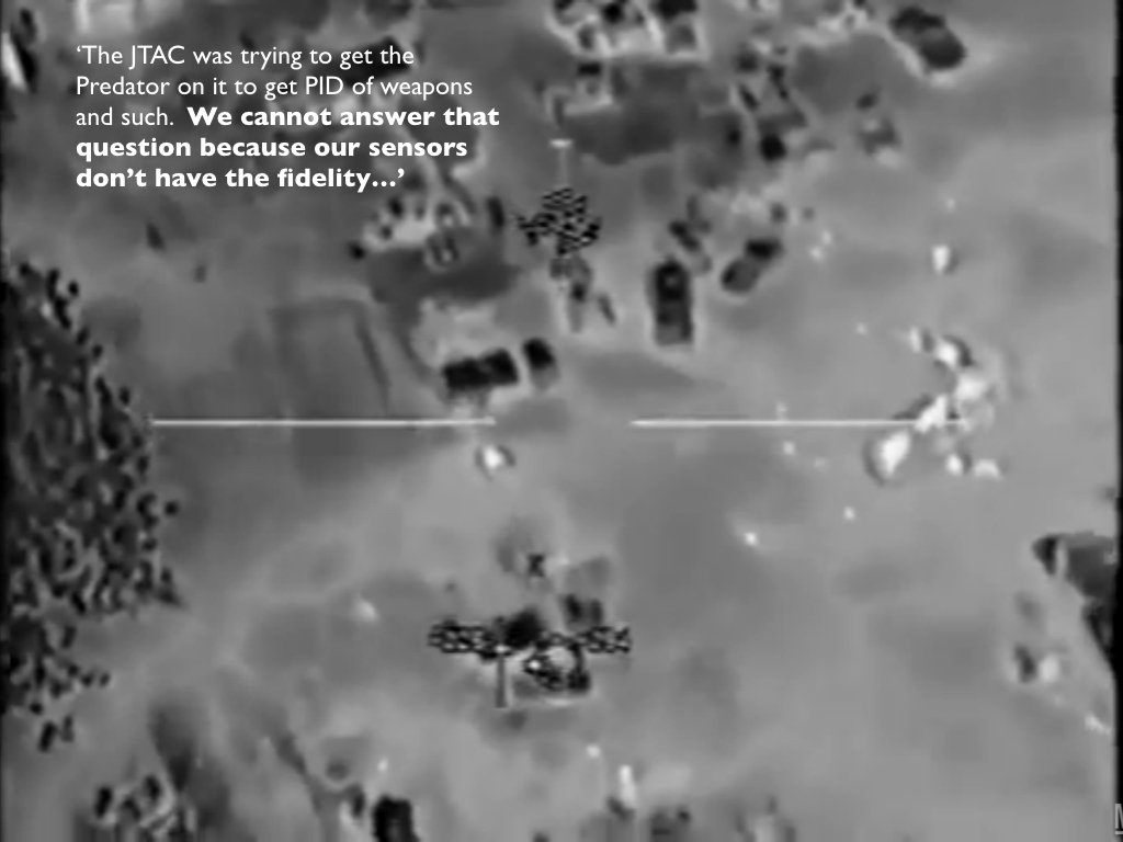
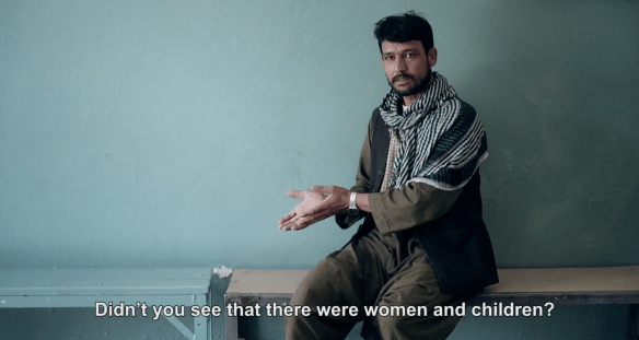
[Still image from NATIONAL BIRD © Ten Forward Films; the image is of the film’s re-enactment of the Uruzgan air strike based on the original transcript of the Predator crew’s radio traffic.]

I’ve been reading the chapter in Pierre Bélanger and Alexander Arroyo‘s Ecologies of Power that provides a commentary on what has become the canonical US air strike in Uruzgan, Afghanistan in February 2010 (‘Unmanned Aerial Systems: Sensing the ecology of remote operational environments’, pp. 267-320).  In my own analysis of the strike I emphasised the production of

a de-centralised, distributed and dispersed geography of militarised vision whose fields of view expanded, contracted and even closed at different locations engaged in the administration of military violence. Far from being a concerted performance of Donna Haraway‘s ‘God-trick’ – the ability to see everything from nowhere – this version of networked war was one in which nobody had a clear and full view of what was happening.

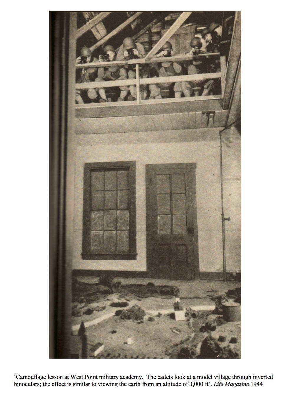
Part of this can be attributed to technical issues – the different fields of view available on different platforms, the low resolution of infra-red imagery (which Andrew Cockburn claims registers a visual acuity of 20/200, ‘the legal definition of blindness in the United States’), transmission interruptions, and the compression of full-colour imagery to accommodate bandwidth pressure…

But it is also a matter of different interpretive fields. Peter Asaro cautions:

‘The fact that the members of this team all have access to high-resolution imagery of the same situation does not mean that they all ‘‘see’’ the same thing. The visual content and interpretation of the visual scene is the product of analysis and negotiation among the team, as well as the context given by the situational awareness, which is itself constructed.’

The point is a sharp one: different visualities jostle and collide, and in the transactions between the observers the possibility of any synoptic ‘God-trick’ disappears. But it needs to be sharpened, because different people have differential access to the distributed stream of visual feeds, mIRC and radio communications. Here the disposition of bodies combines with the techno-cultural capacity to make sense of what was happening to fracture any ‘common operating picture’.

ecologies-of-powerPierre and Alexander’s aim is to ‘disentangle’ the Electromagnetic Environment (EME), ‘the space and time in which communications occur and transmissions take place’, as a Hertzian landscape.  The term is, I think, William J. Mitchell‘s in Me++:

‘Every point on the surface of the earth is now part of the Hertzian landscape – the product of innumerable transmissions and of the reflections and obstructions of those transmissions… The electronic terrain that we have constructed is an intricate, invisible landscape.’

(Other writers – and artists – describe what Anthony Dunne called Hertzian space).

The Hertzian landscape is often advertised – I use the world deliberately – as an isotropic plane.  Here, for example, is how one commercial company describes its activations (and its own product placement within that landscape) in a scenario that, in part, parallels the Uruzgan strike:

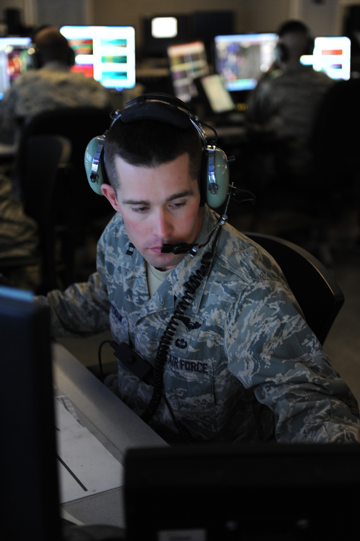
A bobcat growls over the speaker, and Airmen from the 71st Expeditionary Air Control Squadron [at Al Udeid Air Base in Qatar] spring into action within the darkened confines of the Battlespace Command and Control (C2) Center, better known as ‘Pyramid Control.’

Keeping WatchThis single audio cue alerts the Weapons Director that an unplanned engagement with hostile force – referred to as Troops in Contact, or TIC – has occurred somewhere in Afghanistan. On the Weapons Director’s computer monitor a chat room window ashes to distinguish itself from the dozens of rooms he monitors continuously.

More than a thousand kilometers away, a Joint Terminal Attack Controller on the ground has called for a Close Air Support (CAS) aircraft to assist the friendly forces now under assault. The Weapons Director has minutes to move remotely piloted vehicles away from the CAS aircraft’s ight path, to de-conict the air support and ground re from other aircraft, and to provide an update on hostile activity to all concerned.

The Weapons Director has numerous communication methods at his disposal, including VoIP and tactical radio to quickly get the critical information to operators throughout southwest Asia and across the world, including communicating across differently classied networks. This enables key participants to assess the situation and to commence their portions of the mission in parallel.

You can find the US military’s view of the 71st here – it called the Squadron, since deactivated, its ‘eyes in the sky’ – and on YouTube here.

us-marines-command-ops-center-at-patrol-base-jaker-nawa-district-helmand-4-july-2009

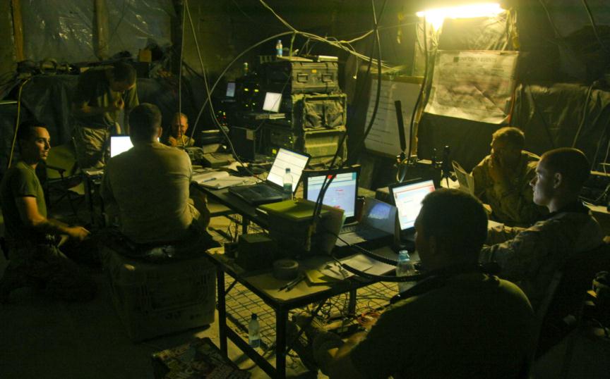
In practice, the Hertzian landscape is no isotropic plane.  Its heterogeneous in space and inconstant in time, and it has multiple, variable and even mobile terrestrial anchor points: some highly sophisticated and centralised (like the Combined Air Operations Center at Al Udeid), others improvisational, even jerry-rigged (see above), and yet others wholly absent (in the Uruzgan case the Joint Terminal Attack Controller with the Special Forces Detachment had no ROVER, a militarized laptop, and so he was unable to receive the video stream from the Predator).

Pierre and Alexander provide an ‘inventory of interferences’ that affected the Uruzgan strike:

‘Saturating the battlefield with multiple electro-magnetic signals from multiple sources, a Hertzian landscape begins to emerge in relief.  In this sense, it is interference – rather than clarity of signal – that best describes a synoptic and saturated environment according to the full repertoire of agencies and affects through which it is dynamically composed, transformed and reconstituted.’ (p. 276)

In fact, they don’t work with the ‘full repertoire of agencies’ because, like most commentators, their analysis is confined to the transcript of radio communications between the aircrews tracking the vehicles and the Joint Terminal Attack Controller on the ground.  Although this excludes testimony from the ground staff in superior command posts (‘operations centres’) in Kandahar and Bagram and from those analysing the video feeds in the continental United States, these actors were subject to the same interferences: but their effects were none the less different.  The catastrophic air strike, as Mitchell almost said, was ‘smeared across multiple sites’… a ‘smearing’ because the time and space in which it was produced was indistinct and inconstant, fractured and febrile.

Here, in summary form, are the interferences Pierre and Alexander identify, an inventory which they claim ‘renders the seemingly invisible and neutral space of the electromagnetic environment extremely social and deeply spatial’ (p. 319).  It does that for sure, but the the exchanges they extract from the transcripts do not always align with the general interferences they enumerate – and, as you’ll see, I’m not sure that all of them constitute ‘interferences’.

uruzgan-ac-130-002

uruzgan-ac-130-001

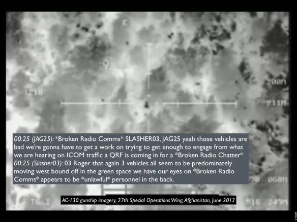
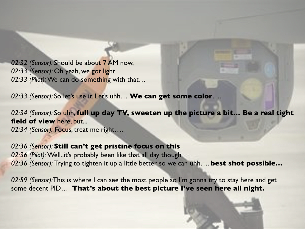
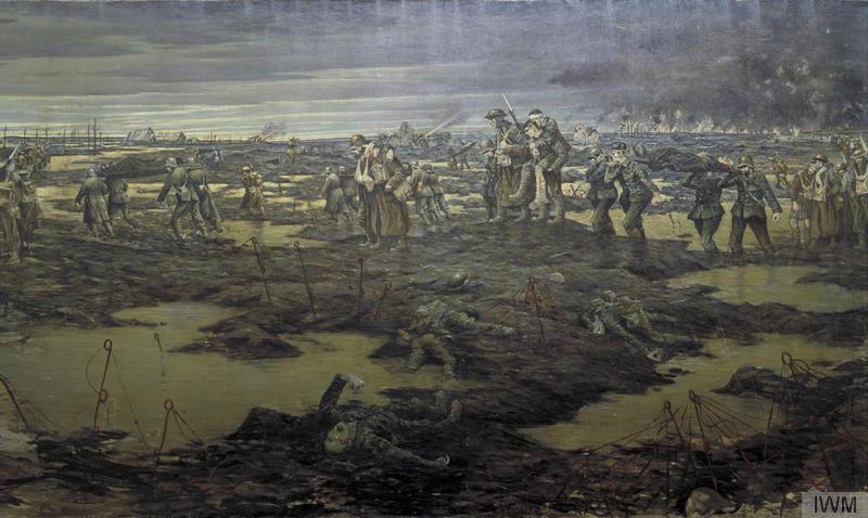
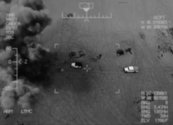
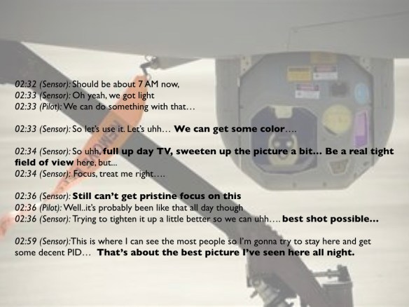
(1) Thermal interference:  The Predator started tracking the three vehicles while it was still dark and relied on infrared imagery to do so (so did the AC-130 which preceded them: see the images above).  Movement turns out to be ‘the key signature that differentiates an intensive landscape of thermal patterns into distinct contours and forces’, but it was not only the movement of the vehicles that mattered.  The crew also strained to identify the occupants of the vehicles and any possible weapons – hence the Sensor Operator’s complaint that ‘the only way I’ve ever been able to see a rifle is if they move them around when they’re holding them’ –  and the interpretation of the imagery introduced ‘novel semiotic complexities, discontinuities and indeterminacies’ (p. 280).

(2) Temporal interference: Times throughout the radio exchanges were standardised to GMT (‘Zulu time’), though this was neither the time at Creech Air Force Base in Nevada (-8 hours) nor in Uruzgan (+4 1/2 hours).  Hence all of those involved were juggling between multiple time zones, and the Sensor Operator flipped between IR and ‘full Day TV’.   ‘Yet this technical daylighting of the world [the recourse to Zulu time] is not always a smooth operation, always smuggling back in local, contingent temporalities into universal time from all sides’ (p. 281).

full-up-day-tv-001

(3) Electromagnetic interference: The participants were juggling multiple forms of communication too – the troops on the ground used multi-band radios (MBITRs), for example, while the aircrew had access to secure military chatrooms (mIRC) to communicate with bases in the continental United States and in Afghanistan and with other aircraft but not with the troops on the ground, while the screeners analysing the video stream had no access to the radio communications between the Ground Force Commander and the Predator crew – and the transcripts reveal multiple occasions when it proved impossible to maintain ‘multiple lines of communication across the spectrum against possible comms failure.’  But this was not simply a matter of interruption: it was also, crucially, a matter of information in one medium not being made available in another (though at one point, long before the strike, the Predator pilot thought he was on the same page as the screeners: ‘I’ll make a radio call and I’ll look over [at the chatroom] and they will have said the same thing.’)

(4) Informational interference:  The transcript reveals multiple points of view on what was being seen – and once the analysis is extended beyond the transcript to those other operations centres the information overload (sometimes called ‘helmet fire’) is compounded.

(5) Altitudinal, meteorologic interference:  The Predator’s altitude was not a constant but was changed to deconflict the airspace as other aircraft were moved into and out of the area; those changes were also designed to improve flight operations (remote platforms are notoriously vulnerable to changing weather conditions) and image quality.  There were thus ‘highly choreographed negotiations of and between contingently constituted spatial volumes – airspace – and [electro-magnetic] spectral spaces, both exploiting and avoiding the thickened electromagnetic atmospheres of communications systems and storms alike’ (p. 288).

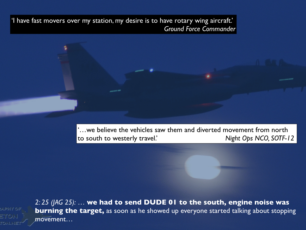
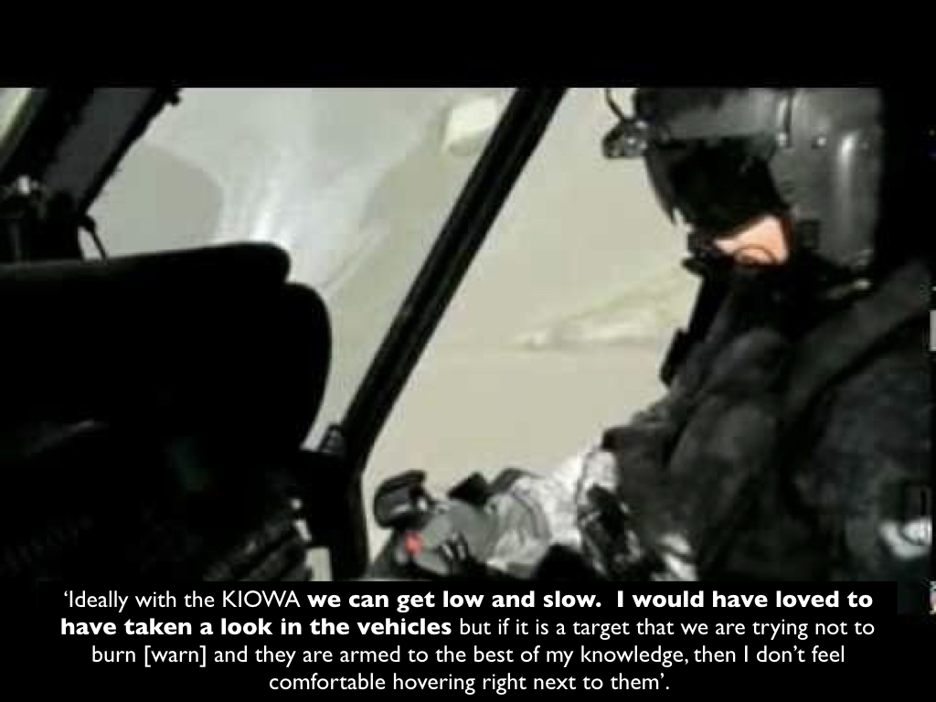
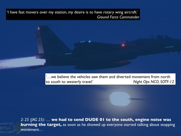
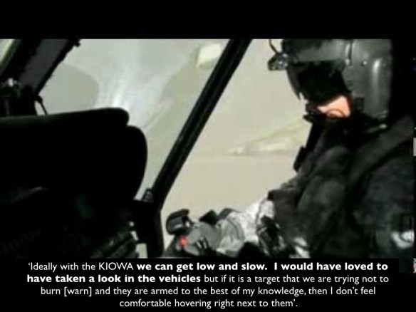
(6) Sensorial interference:  When two strike aircraft (‘fast movers’) were sent to support the Special Forces, the Ground Force Commander ordered them out of the area in case they ‘burn’ (warn) the target; similarly, the OH-158 helicopters did not move in ‘low and slow’ to observe the three vehicles more closely in case that alerted their occupants.

 ‘While the acoustic space of [the Predator] personnel is characterised by speech and static, the occupation of spectral space generates another acoustic space for surface-bound targets of surveillance.  Each aircraft bears a particular acoustic signature … [and] in the absence of visual contact the whines, whirs and wails of encroaching aircraft warn targets of the content of communications… These disparate acoustic spaces reveal the asymmetry of sensory perception and heightened awareness between the graphic (visual) and acoustic channels’ (p. 289).

burning-the-target-001 burning-the-target-2-001

That asymmetry was accentuated because, as Nasser Hussain so brilliantly observed, the video feeds from the Predator were silent movies: none of those watching had access to the conversations between the occupants of the vehicles, and the only soundtrack was provided by those watching from afar.

(7) Orbital interference:  The crowded space of competing communications requires ‘specific orbital coordinations between patterns of  “orbiting” (circling) aircraft and satellites’ (p. 292), but this is of necessity improvisational, involving multiple relays and frequently imperfect – as this exchange cited by Pierre and Alexander indicates (it also speaks directly to (3) above):

02:27 (Mission Intelligence Coordinator MIC): Alright we need to relay that.

02:27 (Pilot): Jag that Serpent 12 can hear Fox 24 on sat in (muffled) flying

02:27 (Pilot): Jag 25 [JTAC on the ground], Kirk97 [Predator callsign]

02:27 (Unknown):..Low thirties, I don’t care if you burn it

02:27 (Sensor): “I don’t care if you burn it”? That really must have been the other guys talking [presumably the ‘fast movers’]

02:27 (JAG 25): Kirk 97, Jag 25

02:28 (Pilot): Kirk 97, go ahead

02:28 (Pilot): Jag 25, Kirk 97

02:28 (JAG 25):(static) Are you trying to contact me, over?

0228 (Pilot): Jag 25, Kirk97, affirm, have a relay from SOTF KAF [Special Operations Task Force at Kandahar Airfield] fires [Fires Officer], he wants you to know that he uhh cannot talk on SAT 102. Serpent 12 can hear Fox 24 on SATCOM, and is trying to reply. Also ,the AWT [Aerial Weapons Team] is spooling up, and ready for the engagement. How copy?

02:28 (JAG 25): Jag copies all

02:28(Pilot):K. Good.

02:29(Pilot): Can’t wait till this actually happens, with all this coordination and *expletive*

(agreement noises from crew)

02:29 (Pilot): Thanks for the help, you’re doing a good job relaying everything in (muffled), MC. Appreciate it

(8) Semantic interference:  To expedite communications the military relies on a series of acronyms and shorthands (‘brevity codes’), but as these proliferate they can obstruct communication and even provoke discussion about their meaning and implication (hence the Mission Intelligence Controller: ‘God, I forget all my acronyms’); sometimes, too, non-standard terms are introduced that add to the confusion and uncertainty.

(9) Strategic, tactical interference:  Different aerial platforms have different operational envelopes and these both conform to and extend ‘a strategic stratigraphy of airspace and spectral space alike’ (p. 296).  I confess I don’t see how this constitutes ‘interference’.

(10) Occupational interference:  The knowledge those viewing the Full Motion Video feeds bring to the screen is not confined to their professional competences but extends into vernacular knowledges (about the identification of the three vehicles, for example): ‘The casual fluency with which particular visuals signals are discussed, interpreted and mined for cultural information shows a broad base of vernacular technical knowledge’ (p. 297).  The example Pierre and Alexander give relates to a discussion over the makes of the vehicles they are tracking, but again I don’t see how this constitutes ‘interference’ – unless that vernacular knowledge collides with professional competences.  The most obvious examples of such a collision are not technical at all but reside in the assumptions and prejudices the crew brought to bear on the actions of those they were observing.  Some were ostensibly tactical – the investigation report noted that the crew ‘made or changed key assessments [about the intentions of those they were observing] that influenced the decision to destroy the vehicles’ and yet they had ‘neither the training nor the tactical expertise to make these assessments’  – while others were cultural (notably, a marked Orientalism).

(11) Physiological interference:  Here Pierre and Alexander cite the corporeality of those operating the Predator: the stresses of working long shifts (and the boredom), the rest breaks that interrupt the ‘unblinking stare’, and the like.

(12) Organizational interference:   At one point the Sensor Operator fantasised about having ‘a whole fleet of Preds up here… ripple firing missiles right and left’  but – seriously, ironically, grumpily: who knows? – adds ‘we’re not killers, we are ISR.’

were-not-killers-were-isr-001

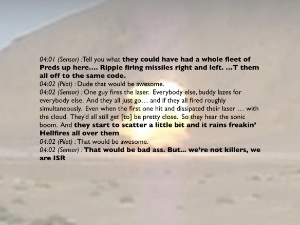
Pierre and Alexander see a jibing of these two missions (though whether that justifies calling this ‘interference’ is another question): ‘Despite the blurry, hairline differences between [Intelligence, Surveillance and Reconnaissance] and kill-chain operations, the ontologies of informational and kinetic environments make for different occupational worlds altogether’ (p. 301).  I’m not sure about that; one of the key roles of Predators – as in this case – has been to mediate strikes carried out by other aircraft, and while those mediations are frequently complicated and fractured (as Pierre and Alexander’s inventory shows) I don’t think this amounts to occupying ‘different occupational worlds’ let alone provoking ‘interference’ between them.

(13) Geographic, altitudinal interference:  This refers to the problems of a crowded airspace and the need for deconfliction (hence the pilot’s call: ‘I got us new airspace so even if they do keep heading west we can track them’).

(14) Cognitive interference: Remote operations are characterised by long, uneventful periods of watching the screen interrupted by shorter periods of intense, focused strike activity – a cyclical process that Pierre and Alexander characterise as an ‘orbital tension of acceleration and deceleration [that] lies at the heart of the killchain’ that profoundly affects ‘cognitive processing in and of the volatile operational environment’ (p. 305).  For them, this is epitomised when the Mission Intelligence Coordinator typed ‘Killchain’ into mIRC and immediately cleared the chat window for all but essential, strike-related communications.

(15) Topographic, organizational interference: Pierre and Alexander claim that ‘the complex relief of the ground, that is terrain and topography, is magnified in remote-split operations’ – this is presumably a reference to the restricted field of view of those flying the platforms – and that this is paralleled by the different levels of command and control to which the crews are required to respond: ‘navigating competing command pyramids is taken in stride with maneuvering around mountains’  (p. 308).  These are important observations, but I don’t see what is gained by the juxtaposition; in the Uruzgan case the Predator was navigating mountainous terrain  (‘You got a mountain coming into view,’ the Safety Observer advises, ‘keep it in a turn’) but the crew was not responding to directives from multiple operations centres.  In fact, that was part of the problem: until the eleventh hour staff officers were content to watch and record but made no attempt to intervene in the operation.

(16) Demographic, physiologic interference:  Here Pierre and Alexander cite both the composition of the crews operating the remote platforms – predominantly young white men who, so they say, exhibit different inclinations to those of ‘conventional’ Air Force pilots – and the repeated identification of the occupants of the suspect vehicles as ‘Military-Aged Males (‘statistical stereotyping’) (p. 309).

uruzgan-survivor

[Still image from NATIONAL BIRD © Ten Forward Films]

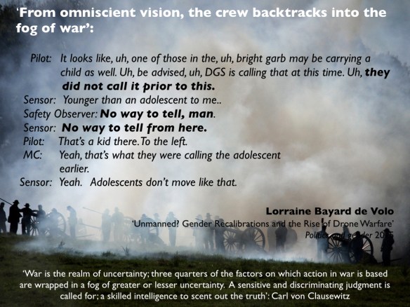
(17) Motile interference: Pierre and Alexander treat the crew’s transition from a gung-ho desire to strike and an absolute confidence in target identification to confusion and disquiet once the possibility of civilian casualties dawns on them as a disjunctive moment in which they struggle to regain analytical and affective control: ‘The revelation of misinterpretation exposes the persistence of interference all along, and generates its own form of cognitive shock’ (p. 312).  This feeds directly into:

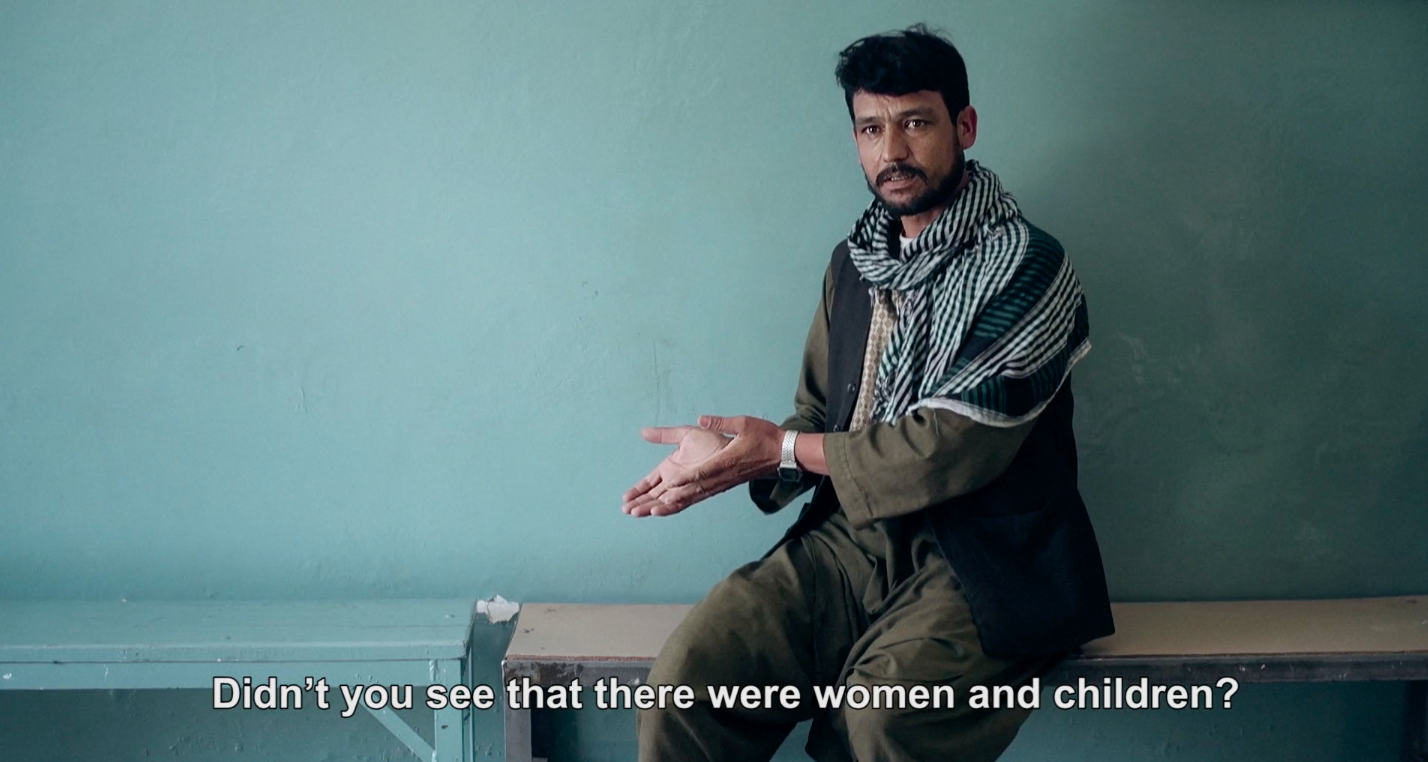
(18) Operational, ecological interference:  As the crew absorbed new information from the pilots of the attack helicopters about the presence of women and children in the vehicles they registered the possibility of a (catastrophic) mistake, and so returned to their ISR mission – taking refuge in their sensors, what they could and could not have seen, and bracketing the strike itself – in an attempt to screen out the discordant information: ‘The optic that initially occasioned the first identifiable instances of misinterpretation is re-activated as a kind of prosthetic inducer of cognitive distance’ (p. 313).  The exchange below (beautifully dissected by Lorraine de Volo) captures this almost therapeutic recalibration perfectly:

uruzgan-no-way-to-tell-from-here-001

(19) Political, epistemological interference:  Here the target is the cascade of redactions that runs through the unclassified version of the transcripts (and, by extension, the investigation report as a whole).  ‘That redaction and the strategic project it serves – secrecy in the form of classification – is not necessarily deployed electromagnetically does not mean its effects are limited to analog media’ since the objective is to command and control a whole ‘ecology of communication'(p. 316) (see my posts here and here).

This inventory is derived from a limited set of transactions, as I’ve said, but it’s also limited by the sensing and communication technology that was available to the participants at the time, so some caution is necessary in extrapolating these findings.  But the general (and immensely important) argument Pierre and Alexander make is that the catastrophic strike cannot be attributed to ‘miscommunication’ – or at any rate, not to miscommunication considered as somehow apart from and opposed to communication.  Hence their focus on interference:

‘Defined by moments of incoherence or interruption of a dominant signal that is itself a form of interference, interferences can take on different and often banal forms such as radio static, garbled signals, forgotten acronyms, misread gestures or even time lapses, which in the remote operational theaters of military missions result in disastrous actions.  Moreover, interference indexes the common media, forms, processes, and spaces connecting apparently disparate communication and signals across distinct material and operational environments.

In this sense, interference is not a subversion of communication but rather a constitutive and essential part of it.  Interference is thus both inhibitor and instigator.  Interference makes lines of communication read, alternatively, as field of interactions.  In this expanded field, interference may complexify by cancelling out communications, blocking or distorting signals, but conversely it may also amplify and augment both the content of sensed information and sensory receptions of the environment of communications.  Interference is what makes sensing ecologies make sense.’ (p. 318)

They also emphasise, more than most of us, that the ‘networks’ that enable drone strikes are three-dimensional (so reducing them to a planar map does considerable violence to the violence), that the connections and communications on which they rely are imperfect and inconstant in time and space, and that these extend far beyond any conventional (or even unconventional) ‘landscape’.  In general, I think, the critical analysis of drone warfare needs to be thickened in at least two directions: to address what happens on the ground, including the preparation of the ground, so to speak; and to reconstruct the fraught geopolitics of satellite communications and bandwidth that so materially shapes what is seen and not seen and what is heard and not heard.  More to come on both.
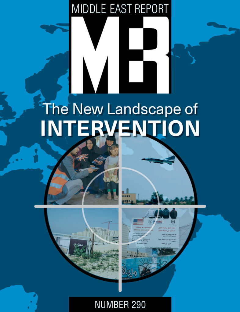
A long day’s journey…

Anti-landscape of the Western Front.001

A note from Antipode to say that the latest edition is now available online and, unless I’ve mis-read things, is open access (for now, at any rate).  It includes what the editors say ‘might well be Antipode‘s longest ever paper’ – pp. 3-56! – my ‘Natures of war’ essay here.

JARMAN Sand.001

The conflict shoreline, colonialism and climate change

Conflict_Shoreline_web

When Eyal Weizman was in Vancouver last March – joining us for Gaston Gordillo‘s  workshop on Space, materiality and violence at the Peter Wall Institute for Advanced Studies – he delivered a public lecture on The Conflict Shoreline: Colonialism as Climate Change.

It’s now available as an extended essay (96 pp) from Steidl in association with Cabinet Books:

The village of al-‘Araqib has been destroyed and rebuilt more than seventy times in the “battle over the Negev,” an ongoing Israeli state campaign to uproot the Bedouins from the northern threshold of the desert. Unlike other frontiers fought over during the Israel–Palestine conflict, however, this threshold is not demarcated by fences and walls but advances and recedes in response to cultivation, colonization, displacement, urbanization, and climate change.

The fate of al-‘Araqib, like that of other Bedouin villages along the desert’s threshold, its “aridity line,” is bound up with deep environmental changes. But whereas even the most committed environmentalists today conceive of climate change as an accidental and unintentional side effect of modernity, Israeli architect and theorist Eyal Weizman argues that from the point of view of colonial history, climate change has never been simply collateral damage. It has always been a stated goal; “making the desert bloom” is, in effect, “changing the climate.”

In examining this history, Weizman outlines attempts—from the Ottoman era through the period of European colonization to the present—to scientifically define, measure, and map the threshold of the desert. Such efforts have been important because imperial and, later, national governments—whose laws have never recognized property rights in the desert—aimed to push back this threshold as they tried to expand the limits of arable land and bring the nomads under state control. In the Negev, the displacement of the weather and the displacement of the Bedouins have gone hand in hand. But while the desert edge, and the Bedouins, have been driven further and further south, global climate change today acts as a major counterforce. Predictably, the Bedouins are caught in the middle.

Brilliantly researched and argued, Weizman’s text—part detective story, part history lesson, and part scientific analysis—explores the changing threshold of the Negev through the extraordinary contemporary photographs of American artist Fazal Sheikh, as well as an array of documents, maps, and images, including historical aerial imagery, remote sensing data, state plans, court testimonies, and nineteenth-century travelers’ accounts. Together, these disparate forms of evidence establish the “conflict shoreline” as a border along which climate change and political contestation are deeply, perilously entangled.

You can find some of the background, and the relation to Eyal’s Forensic Architecture project, in an interview earlier this year:

I’m mostly trying to establish forensic architecture as a critical field of practice and as an agency that produce and disseminate evidence about war crimes in urban context. Recent forensic investigations in Guatemala and in the Israeli Negev involved the intersection of violence and environmental transformations, even climate change. For trials and truth commissions, we analyze the extent to which environmental transformation intersect with conflict.

The imaging of this previously invisible types of violence—‘environmental violence’ such as land degradation, the destruction of fields and forests (in the tropics), pollution and water diversion, and also long term processes of desertification—we use as new type of evidence of processes dispersed across time and space. There are other conflicts that unfold in relation to climatic and environmental transformations and in particular in relation to environmental scarcity.

Conflict has reciprocal interaction with environment transformation: environmental change could aggravate conflict, while conflict tends to generate further environmental damage. This has been apparent in Darfur, Sudan where the conflict was aggravated by increased competition over arable due to local land erosion and desertification. War and insurgency have occurred along Sahel—Arabic for ‘shoreline’—on the southern threshold of the Sahara Desert, which is only ebbing as million of hectares of former arable land turn to desert. In past decades, conflicts have broken out in most countries from East to West Africa, along this shoreline: Eritrea, Ethiopia, Somalia, Sudan, Chad, Niger, Mali, Mauritania, and Senegal. In 2011 in the city of Daraa, farmers’ protests, borne out of an extended cycle of droughts, marked the beginning of the Syrian civil war. Similar processes took place in the eastern outskirts of Damascus, Homs, al-Raqqah and along the threshold of the great Syrian and Northern Iraqi Deserts. These transformations impact upon cities, themselves a set of entangled natural/man-made environments. The conflict and hardships along desertification bands compel dispossessed farmers to embark upon increasingly perilous paths of migrations, leading to fast urbanization at the growing outskirts of the cities and slams.

I’m trying to understand these processes across desert thresholds. There has been a very long colonial debate about what is the line beyond which the desert begins. Most commonly it was defined as 200 mm rain per annum. Cartographers were trying to draw it, as it represented, to a certain extent, the limit of imperial control. From this line on, most policing was done through bombing of tribal areas from the air. Since the beginning, the emergence of the use of air power in policing in the post World War I period—aerial control, aerial government—took form in places that were perceived, at the time, as lying beyond the thresholds or edges of the law. The British policing of Iraq, the French in Syria, and Algeria, the Italians in Libya are examples where control would hover in air.

Up to now I was writing about borders that were physical and manmade: walls in the West Bank or Gaza and the siege around it—most notably in Hollow Land (2007). Now I started to write about borders that are made by the interaction of people and the environment—like the desert line—which is not less violent and brutal. The colonial history of Palestine has been an attempt to push the line of the desert south, trying to make it green or bloom—this is in Ben Gurion’s terms—but the origins of this statement are earlier and making the desert green and pushing the line of the desert was also Mussolini’s stated aim. On the other hand, climate change is now pushing that line north.

Following not geopolitical but meteorological borders, helps me cut across a big epistemological problem that confines the writing in international relations or geopolitics within the borders organize your writing. Braudel is an inspiration but, for him, the environment of the Mediterranean is basically cyclically fixed. The problem with geographical determinism is that it takes nature as a given, cyclical, milieu which then affects politics—but I think we are now in a period where politics affects nature in the same way in which nature affects politics. The climate is changing in the same speed as human history.

fazal-sheikh-desert-bloom-web

The conflict shoreline was originally commissioned in response to Fazal Sheikh’s Desert Bloom series (part of his remarkable Erasure trilogy: see image stream above, and also here).

Truth Commission

It has also been submitted as evidence for Zochrot‘s project on transitional justice, the Truth Commission on the responsibility of Israeli society for the events of 1948–1960 in the South.

Transitional justice mechanisms address the needs of communities and countries in conflict to cope with systematic abuses and structural injustices in order to facilitate reconciliation. Communities in conflict, both victims and victimizers, have developed a variety of innovative approaches to addressing the needs that result from ongoing conflicts. Hitherto, practices informed by the transitional justice paradigm have been used mainly to accompany and heal societies and communities in political transitions such as from totalitarian to democratic rule, or from an apartheid regime as in South Africa to an egalitarian democratic regime. Usually, these practices have been applied after a violent conflict had ended in a peace agreement, as in the former Yugoslavia, or in an armistice, as in Cyprus or Northern Ireland.

Many activists around the world have demonstrated time and again that silencing and ignoring the past prevent conflict resolution and the attainment of true reconciliation. Therefore, even in situations of seemingly intractable conflicts, several initiatives by civil society organizations, trade union or social religious organizations similar to state-sponsored mechanisms of transitional justice have sprung around the world. For the past 40 years, these initiatives have acted without government backing to bring resolve violent conflicts.

The Truth Commission established by Zochrot now joins these initiatives. The first of its kind in Israel/Palestine, the Commission is unique in that … it is active while the conflict is still ongoing, and against the background of the regime’s evasion of responsibility to the events of the Nakba, which began in 1948 and is still ongoing [the Nakba or ‘catastrophe’ refers to the forced eviction and dispossession of the Palestinian people set in motion by the war of 1948]. The Truth Commission for Exposing Israeli Society’s Responsibility for the Events of 1948-1960 in the South which started its deliberations in late October 2014…

The Commission seeks to expose the events of the Nakba during those years – events that have profound implications for the ongoing Nakba experienced by the Palestinian Bedouins to this day. The Commission examines testimonies by Palestinian displaced persons and refugees, as well as Jews who lived in the south and Jewish fighters who took part in displacement and expulsion operations in the area. In addition, the Commission peruses relevant archive materials. The Commission’s report will be designed to encourage the Jewish society in Israel to accept responsibility for past injustices in the south, with reference to the ongoing Nakba, and for redressing them.

You can also read Tom Pessah‘s report for +972 here.

Staging the landscapes of war – with noises off

NEVINSON The harvest of battle

I’ve been tracing commentaries on Kurt Lewin‘s classic essay on what we might call the topological phenomenology of the battlefield, published in 1917 as ‘Kriegslandschaft‘ (‘landscape of war’ or, loosely, ‘warscape’), which was based on his experience on the Western Front in the First World War. I’ve been particularly interested in his account of the way in which an ordinary landscape is transformed by war.

William Boyd captured what I have in mind in The new confessions:

‘Take an idealized image of the English countryside – I always think of the Cotswolds in this connection… You know exactly the sort of view it provides. A road, some hedgerowed lanes, a patchwork of fields, a couple of small villages… The eye sweeps over these benign and neutral features unquestioningly.

‘Now, place two armies on either side of this valley. Have them dig in and construct a trench system. Everything in between is suddenly invested with new sinister potential: that neat farm, the obliging drainage ditch, the village at the crossroads become key factor sin strategy and survival. Imagine running across those intervening fields in an attempt to capture positions on that gentle slope opposite… Which way will you go? What cover will you seek? … Try it the next time you are on a country stroll and see how the most tranquil scene can become instinct with violence. It only requires a change in point of view.’

lewin_kurtI’ve discussed this passage before, but what interested Lewin was the way in which the landscape changed for the soldier as he approached the front, moving from a ‘landscape of peace’ to a ‘landscape of war’ – what he described as the production of a ‘directive landscape’.  You can find an English translation here, but it’s behind a paywall I can’t scale: Art In Translation, 1 (2)( 2009) 199-209.  (If anybody has a ladder, please let me know).

En route, I stumbled on a fascinating PhD thesis by Greer Crawley, Strategic Scenography: staging the landscape of war (University of Vienna, 2011). I’ve discussed various conceptions of the ‘theatre of war’ several times before (see for example here, here and here), but Greer provides a much fuller and richer account.  Here is the abstract:

This dissertation is concerned with the construction of ‘theatres of war’ in the target landscapes of 20th century military conflict in Europe and America. In this study of the scenography of war, I examine the notion of the staged landscape and the adoption of theatrical language and methodologies by the military. This is a multi-disciplinary perspective informed by a wide range of literature concerning perception, the aerial view, camouflage and the terrain model. It draws on much original material including declassified military documents and archival photographs. The emphasis is on the visualisation of landscape and the scenographic strategies used to create, visualise and rehearse narratives of disguise and exposure. Landscape representation was constructed through the study of aerial photographs and imaginative projection. The perceptual shifts in scale and stereoscopic effects created new optical and spatial ‘truths’. Central to this analysis is the place of the model as strategic spectacle, as stage for rehearsal and re-enactment through performance and play. This research forms the context for an exploration of the extension and translation of similar scenographic strategies in contemporary visual art practice. Five case studies demonstrate how the artist as scenographer is representing the political and cultural landscape.

2011-02-25_0648070 (dragged)

And the Contents (the summaries are Greer’s own):

Chapter 1: Scenographic strategies

Theatre of War/Strategic Fantasy/Staging the Landscape

This chapter identifies the scenographic strategies that produce the performance landscape for the rehearsal and re-enactment of the Theatre of War. The aim is to define what is meant by strategic scenography and to establish the basic theoretical foundations upon which to build my argument.

Chapter 2: The Aerial Perspective

Aerial Theatre/The Stereoscopic View

This chapter focuses on the aerial view and the methodology of the stereoscope. This analysis of the relationship between scenography and topography from an aerial perspective expands on theories of aerial perception and stereoscopy. Drawing on the experiences of the reconnaissance pilots and photo interpreters during wartime, it attempts to understand the scopic conditions under which they visualised the landscape.

Chapter 3: Strategies of Perception

Camouflage Strategies/Fake Nature/The Scenic Effects

This is a key chapter which looks at the work of Kurt Lewin’s important contribution to an understanding of the perception of landscape. The second section deals specifically with the camouflage strategies adopted by the camoufleurs when staging their illusions in the First and Second World Wars. It provides a historical overview of the main camouflage strategies and then focus on particular scenic elements, e.g. scenery, lighting, props, sound, costume.

Chapter 4: The Territory of the Model

Maps, Models and Games/ The Model as Spectacle/The Terrain Model

This chapter begins with an examination of the methodologies of the map, model and games; the role of mimesis and performativity and the representation of the terrain. What follows is a consideration of the model as a strategic spectacle and its use to represent political ideologies, commercial and military interests and utopian visions. Within an historical context, it examines how the application of new technologies and scopic regimes has expanded the scenographic possibilities of the terrain model.

Chapter 5: Artists’ Manoeuvres

Wafa Hourani and Michael Ashkin − Nomos/Gerry Judah − The Crusader/Mariele Neudecker – Seduction Chaff/Katrin Sigurdardottir – Mappings/Hans Op de Beeck – St Nazaire

This chapter is an exploration of the deployment of scenographic strategies in contemporary artistic practice. Through five case studies it examines how the artist as scenographer has adopted theatrical practices and the methodologies of the model, camera and film as means of representing the political and cultural landscape.

Greer is currently a lecturer in Scenography at Royal Holloway, University of London and in BA and MA Spatial Design at Buckinghamshire New University.  You can download her thesis here – it’s a feast of delights, with marvellous illustrations and a perceptive text.

MoratSoundsAs you can see, Greer’s work focuses on the visual, and I’m equally interested in the role of the other senses in apprehending and navigating the battlefield – hence my continuing interest in corpography (see here and here).  So I was also pleased to find a newly translated discussion of the soundscape of the Western Front: Axel Volmar,  ‘”In storms of steel”: the soundscape of World War I’, in Daniel Marat (ed), Sounds of modern history: auditory cultures in 19th and 20th century Europe (Oxford: Berghahn, 2014) pp. 227-255; a surprising amount of the text can be accessed via Google Books, but you can also download the draft version via academia.edu.  More on Axel’s work (and other downloads, in both German and English) here.

And this too takes us back to Lewin:

‘…new arrivals to the front had not only had to leave behind their home and daily life, but also the practices of perception and orientation to which they were accustomed. With entry into the danger zone of battle, the auditory perception of peacetime yields to a, in many respects, radicalized psychological experience—a shift that the Gestalt psychologist, Kurt Lewin, attempted to articulate with the term “warscape”: for the psychological subject, objects lost most of their peacetime characteristics during wartime because they were henceforth evaluated from a perspective of extreme pragmatism and exclusively in terms of their fitness for war….

‘In place of day-to-day auditory perception, which tended to be passive and unconscious, active listening techniques came to the fore: practices of sound analysis, which might be described as an “auscultation” of the acoustic warscape—the method physicians use to listen to their patients by the help of a stethoscope. In these processes, the question was no longer how the noises as such were structured (i.e. what they sounded like), but rather what they meant, and what consequences they would bring with them for the listeners in the trenches. The training of the ear was based on radically increased attentiveness.

The subject thrust to the front thus comprised the focal point of an auditory space in which locating and diagnostic listening practices became vital to survival.’

For more on sound analysis, see my discussion of sound-ranging on the Western Front here, and the discussion in ‘Gabriel’s Map’ (DOWNLOADS tab).