The God trick and the administration of military violence

JOC staring at screen 24afghan-600

Here is the abstract for my keynote at the Lancaster symposium on Security by remote control next month; it’s a development from my presentation at the AAG in Tampa, and I’ll provide more details as I develop the argument.

The God trick and the administration of military violence

Advocates have made much of the extraordinary ability of the full motion video feeds from Predators and Reapers to provide persistent surveillance (‘the all-seeing eye’), so that they become vectors of the phantasmatic desire to produce a fully transparent battlespace.  Critics – myself included – have insisted that vision is more than a biological-instrumental capacity, however, and that it is transformed into a conditional and highly selective visuality through the activation of a distinctively political and cultural technology.  Seen thus, these feeds interpellate their distant viewers to create an intimacy with ground troops while ensuring that the actions of others within the field of view remain obdurately Other.

But the possibility of what Donna Haraway famously criticised as ‘the God-trick’ – the ability to see everything from nowhere in particular – is also compromised by the networks within which these remote platforms are deployed.  In this presentation I re-visit an air strike on three vehicles in Uruzgan province, Afghanistan, in February 2010, in which more than 20 civilians were killed in a helicopter attack prompted, in large measure, by video feeds from a Predator providing support to a Special Forces detachment in the vicinity.  Most commentaries – including mine – have treated this in terms of a predisposition on the part of the Predator crew to (mis)read every action by the victims as a potential threat.  But a close examination of the official investigations that followed, by the US Army and then the US Air Force, reveals a much more complicated situation.  The Predator was not the only ‘eye in the sky’, its feeds entered into a de-centralized, distributed and dispersed geography of vision in which different actors at different locations inside and outside Afghanistan saw radically different things, and the breaks and gaps in communication were as significant as the connections.  In short, much of later modern war may be ‘remote,’ but there’s considerably less ‘control’ than most people think.

I still haven’t found what I’m looking for

U2 (USAF photograph)

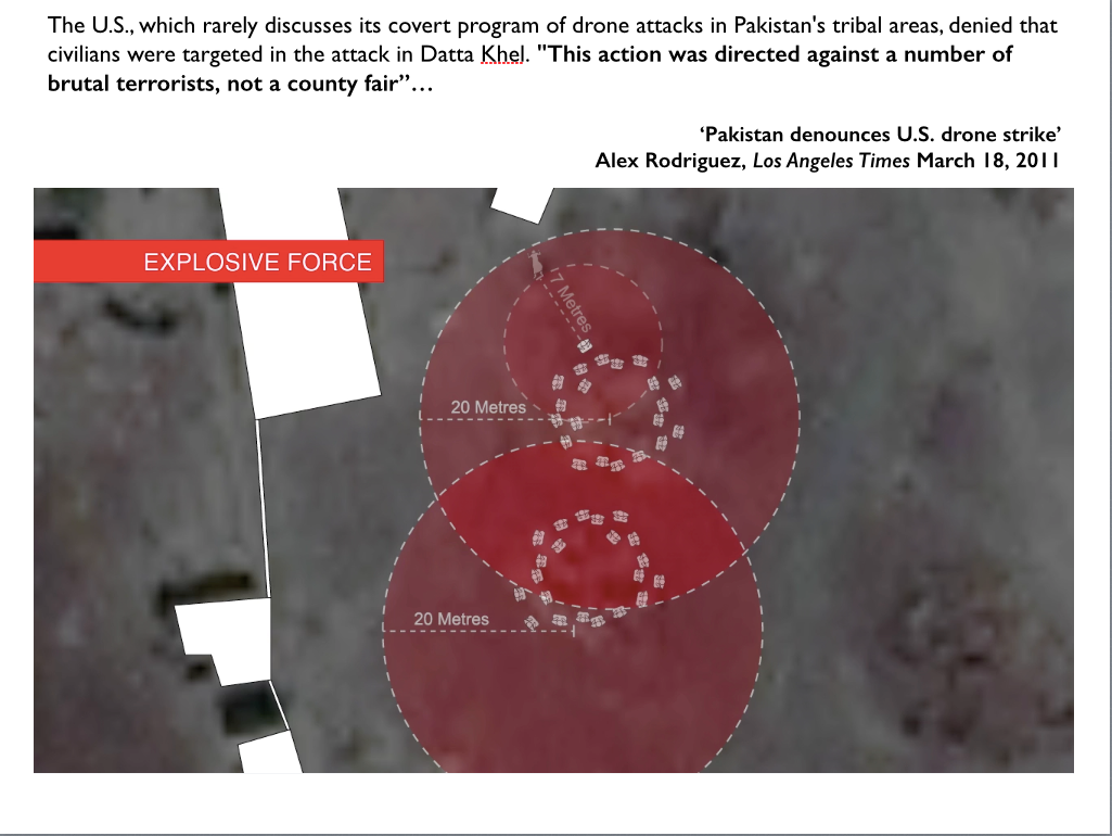
Rummaging around for more people working on militarized vision, I encountered a forum on Military optics and Bodies of difference held at Berkeley’s Center for Race and Gender earlier this year, and through that the research of Katherine Chandler, who holds a Townsend Center for the Humanities Dissertation Fellowship in the Department of Rhetoric.  Her dissertation in progress is entitled Drone Flight and Failure: the United States’ Secret Trials, Experiments and Operations in Unmanning, 1936 – 1973, which promises to fill in a crucial gap in conventional genealogies of today’s remote operations.

As you’ll see if you visit her website here, Katherine is an accomplished artist as well as researcher and critic.  You can read her essay on ‘System Failures’, which includes a discussion of Trevor Paglen‘s Drone Vision and Omer Fast‘s 5,000 Feet is the Best, at The New Inquiry (August 2012) here, and find a fuller discussion of Fast’s video situated within what Katherine calls the ‘knowledge politics’ and political ecologies of remote operations on pp. 63-74 of Knowledge politics and intercultural dynamics here.

Here is the abstract for her talk at the forum, Unmanning Politics: Aerial Surveillance 1960-1973:

u2_spy_plane_incident_newspaper_clipping
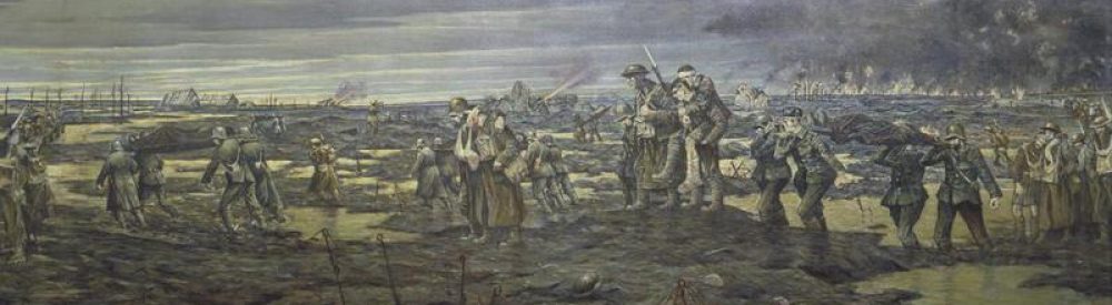
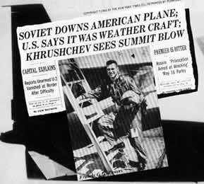
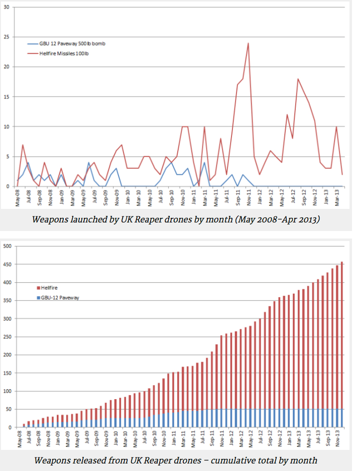
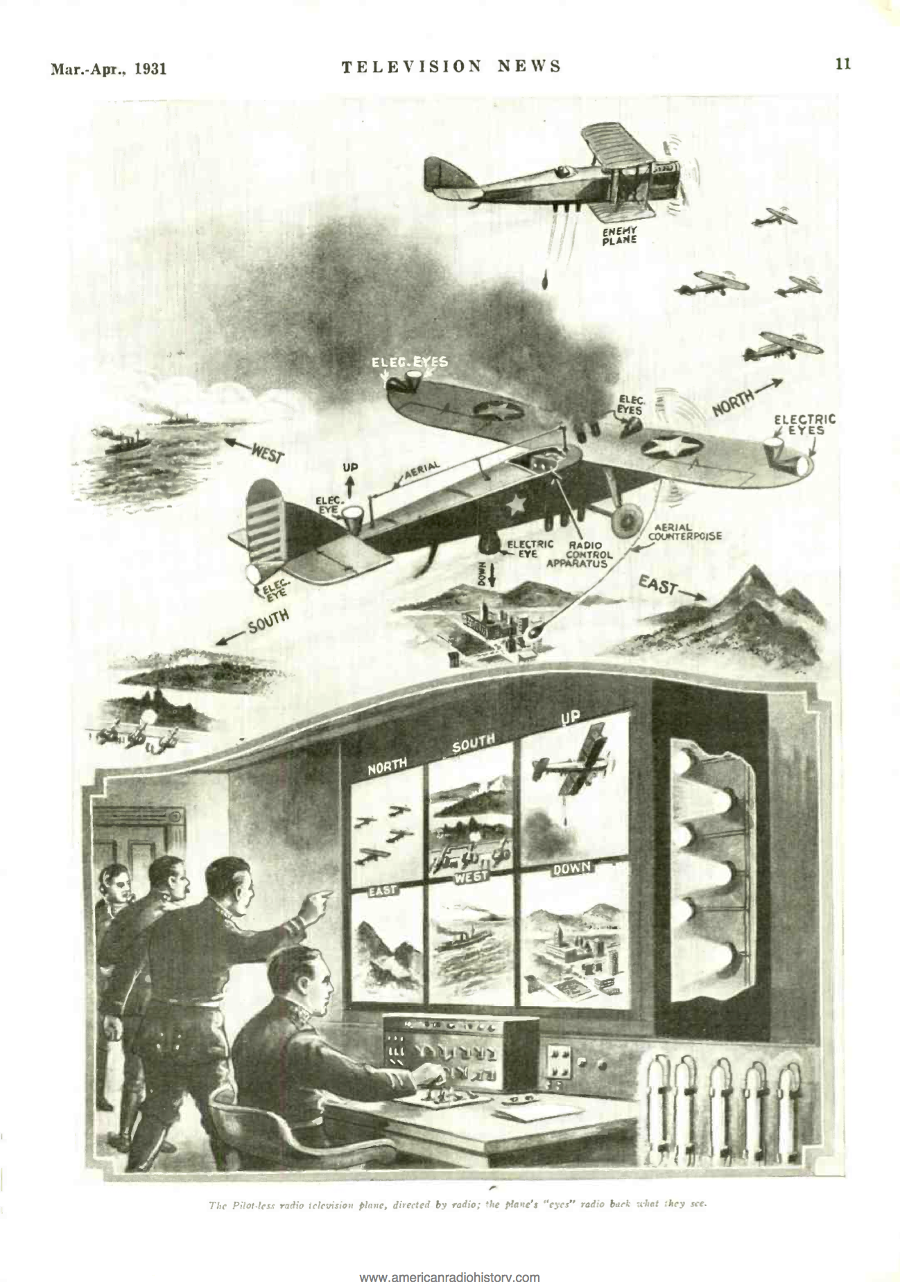
On May 1, 1960, Francis Gary Powers’ U-2 plane was shot down over the Soviet Union while on a secret reconnaissance mission. The ensuing diplomatic fallout caused the cancellation of the Paris Summit between Dwight Eisenhower and Nikita Khrushchev. Less well known, in April 1960, Robert Schwanhausser, an engineer for Ryan Aeronautical, briefed the United States Air Force on the possibility that its Firebee target drone, used at the time for air defense training, might be re-engineered as an unmanned reconnaissance plane. In the weeks following the Powers incident, the Air Force began wholesale negotiations with Ryan Aeronautical to develop a pilotless spy plane and, on July 8, 1960, the company was given funding to begin the project. Among the noted advantages were: “political risk is minimized due to the absence of a possible prisoner” (“Alternative Reconnaissance System,” 1960). I investigate the resulting Lightning Bugs, flown for three-thousand reconnaissance missions in Southeast Asia between 1964 and 1973. 

Researching how aircraft were unmanned during the Cold War is instructive both in the ways they mimic contemporary unmanned combat aerial vehicles and trouble assumptions about them. I follow how unmanned systems operated within the logics of American Cold War politics and their perceived usefulness geopolitically – crossing borders as spy aircraft, collecting and jamming electronic signals, and gathering battlefield reconnaissance. I ask how conquest, and the ensuing assumptions of empire, colonialism and race, underlie the unmanning of military aircraft, even while these aspects were purposefully, although, unsuccessfully occluded through the idea that technologies could mitigate political risks. Moreover, unmanned reconnaissance projects were cancelled at the end of the Vietnam War and their failure provides clues about what might be left out of visions of aerial control and the ways politics, and human vulnerabilities, persisted in spite of efforts to engineer systems that would suggest otherwise.

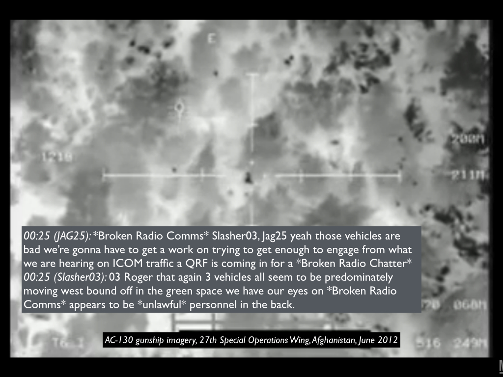
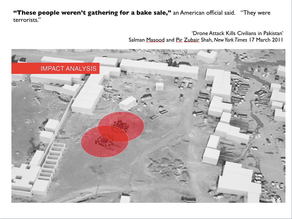
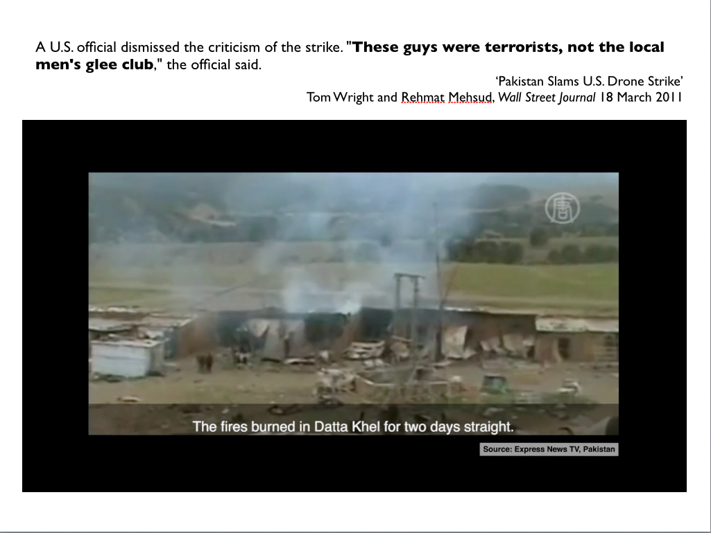
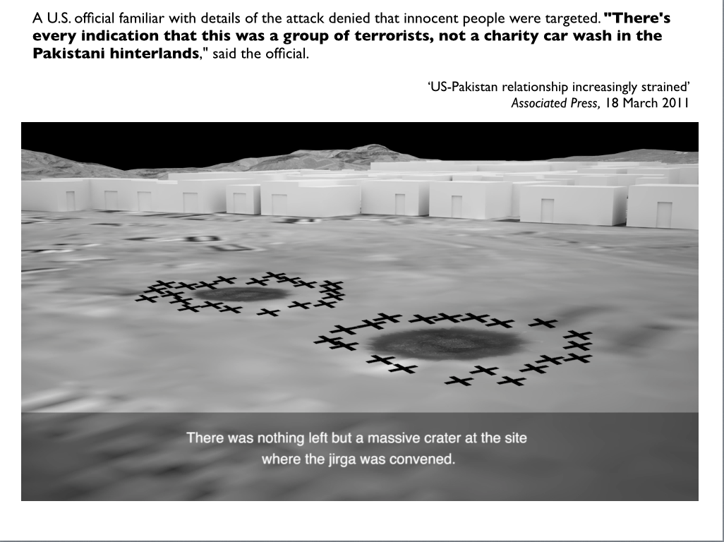
The legitimacy of contemporary drone strikes relies on the ability of unmanned aircraft to “see” enemy targets. Yet, as Isabel Stengers has argued, any representation gives value. Looking at the few available images from these early unmanned reconnaissance flights, I move between what is seen and unseen to examine how values, particularly, secrecy and control, are formed through unmanned reconnaissance. Claiming to produce a mechanical, rather than political, view of the territories surveyed, I show how the supposedly apolitical lens of the drone occludes how politics, industry and military come together to privilege certain positions and target others.

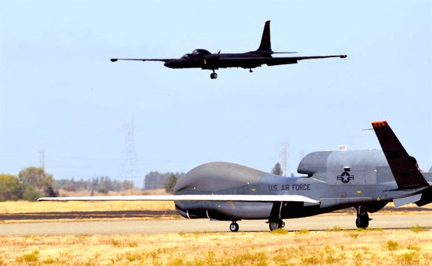
Interesting stuff – especially that first paragraph linking ‘un-manning’ to the U-2.  There is a strange irony here, because until this year the US Air Force had in fact favoured its fleet of 33 U-2 (‘Dragon Lady’) aircraft [one of which is shown at the top of the photograph] over the high-altitude Global Hawk [shown at the bottom], so much so that it had asked for permission to cancel its orders for the new Block 30 Global Hawks and place others in storage.

GlobalHawk_USAFAirmanFirstClassBobbyCummings

You may be surprised to discover that the U-2 is still flying, but the airframe has been repeatedly modified and so too has the network in which it is embedded.  One pilot explained:

“The U-2 started out only carrying a wet-film camera. Now, with today’s technology, I’m alone up there, but I may be carrying 40 to 50 Airmen via data link who are back at a (deployable ground station).”

U-2 flying hours in Afghanistan and Iraq (New York Times)
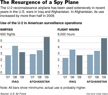
It’s important to remember that Predators and Reapers are not the only platforms streaming imagery to the Air Force’s Distributed Common Ground System.  The U-2 was given a new lease of life by the Gulf War in 1991, when nine U-2s flying out of the UAE  provided 50 per cent of all imagery and over 90 per cent of all ground forces targeting imagery.  During the invasion of Iraq in 2003 U-2s flew only 19 percent of the air reconnaissance missions, but they provided more than 60 per cent of the signals intelligence and 88 per cent of battlefield imagery.  The continuing wars in Afghanistan and Iraq confirmed that the U-2’s original, strategic significance had been eclipsed by its new tactical role.  Chris Pocock explains:

“The U-2 today is more a tactical intelligence gatherer…  It supports ground operations on a daily basis, flying over Afghanistan, flying around Korea, flying in the eastern Mediterranean, doing all those things every day and it’s actually not only providing intelligence that is analyzed for the benefit of those ground troops, but it’s actually in contact with those ground troops in real time.”

And that close contact – akin to the intimacy remote operators in the continental United States claim when they say they are not 7,000 miles but 18 inches from the battlespace, the distance from eye to screen – takes its toll on the U-2 pilots too.  In addition to the extraordinary pressures flying the U-2 imposes on their bodies, one USAF physician insisted that ’emotionally… they’re wrung out from that… When you’re talking to somebody on the radio and there’s gunfire in the background… you’re not taking a nap while that’s happening.’

Writing in the New York Times, Christopher Drew provided a revealing example:

Major Shontz said he was on the radio late last year with an officer as a rocket-propelled grenade exploded. “You could hear his voice talking faster and faster, and he’s telling me that he needs air support,” Major Shontz recalled. He said that a minute after he relayed the message, an A-10 gunship was sent to help.

In fact, that last clause can be generalised; the U-2 has often been deployed in close concert with other platforms, including Predators and Reapers.  Drew again:

The U-2’s altitude [70,000 feet or more], once a defense against antiaircraft missiles, enables it to scoop up signals from insurgent phone conversations that mountains would otherwise block.  As a result, Colonel Brown said, the U-2 is often able to collect information that suggests where to send the Predator and Reaper drones, which take video and also fire missiles. He said the most reliable intelligence comes when the U-2s and the drones are all concentrated over the same area, as is increasingly the case.

Part of the reason for that is that the U-2 has such an advanced imagery system:

Even from 13 miles up its sensors can detect small disturbances in the dirt, providing a new way to find makeshift mines [IEDs] that kill many soldiers.  In the weeks leading up to the [2010] offensive in Marja, military officials said, several of the … U-2s found nearly 150 possible mines in roads and helicopter landing areas, enabling the Marines to blow them up before approaching the town.

Marine officers say they relied on photographs from the U-2’s old film cameras, which take panoramic images at such a high resolution they can see insurgent footpaths, while the U-2’s newer digital cameras beamed back frequent updates on 25 spots where the Marines thought they could be vulnerable.

U-2 preparing for takeoff 'in SW Asia' (USAF/Eric Harris)

For all that,  in the last two years the Air Force’s plan to cut the Global Hawk program was repeatedly over-ridden by Congress, in response to an extraordinary campaign waged by Northrop Grumman, which launched what Mark Thompson called ‘its own ISR – intelligence, surveillance and reconnaissance – mission over Capitol Hill to decide where to strategically target cash-bombs to keep its plane, and more of them, flying for another day’: you can find a  full report at the Center for Public Integrity here.

The Air Force has now accepted the retirement of Lockheed Martin’s ageing Cold warrior, because (so it says) the cost per flying hour of the Hawk has now fallen below that of the U-2 ($24,000 vs. $32,000).  ‘U2 shot down by budget cuts’, is how PBS put it, while the Robotics Business Review triumphantly announced ‘Here comes automated warfare’.

Even so, cost per flying hour is not the whole story, as Amy Butler explains.  Part of the problem is logistical and, by extension, geopolitical: ‘Global Hawks based in Guam have to transit for hours just to reach North Korea, whereas the U-2, based at Osan air base, South Korea, has a shorter commute’ (details of the Hawk’s global basing can be found here).

A second issue is reliability, which bedevils all major UAVs and makes cost per flying hour a dubious index:

‘Intelligence, surveillance and reconnaissance collection is in high demand, and aircraft downtime is extremely worrisome for combatant commanders. In the Pacific, 55% of Global Hawk’s missions were canceled in fiscal 2013; 96% of the U-2’s missions were achieved. The U-2 was also scheduled for nearly three times as many missions. Global Hawk lacks anti-icing equipment and is not able to operate in severe weather.’

Finally, critics continue to complain that the sensors on the U-2 remain superior to those on the Hawk and provide a wider field of view.  According to a report from Eric Beidel,

The Global Hawk carries Raytheon’s Enhanced Integrated Sensor Suite, which includes cloud-penetrating radar, a high-resolution electro-optical digital camera and an infrared sensor. But the U-2’s radar can see farther partly because the plane can fly at altitudes over 70,000 feet, about 10,000 feet higher than a Global Hawk. A longer focal length also gives the U-2’s camera an edge, experts said…

Air Force Chief of Staff Gen. Norton Schwartz has said that the drone’s sensors just weren’t cutting it. Further, the U-2 can carry a larger payload, up to 5,000 pounds compared to 3,000 pounds for the Global Hawk.

“Some of the most useful sensors are simply too big for Global Hawk,” said Dave Rockwell, senior electronics analyst at Teal Group Corp. He referred to an optical bar camera on the U-2 that uses wet film similar to an old-fashioned Kodak. “It’s too big to fit on Global Hawk even as a single sensor.”

All of these technical considerations are also political ones, as Katherine’s abstract indicates, and none of them answers the other questions she poses about what can and cannot be seen…

Seeing Machines

VIRILIO Vision machineIn a series of posts on photography Trevor Paglen provides some ideas that intersect with my own work on Militarized Vision and ‘seeing like a military’.  First, riffing off Paul Virilio, Trevor develops the idea of photography as a ‘seeing machine‘:

‘Seeing machines is an expansive definition of photography. It is intended to encompass the myriad ways that not only humans use technology to “see” the world, but the ways machines see the world for other machines. Seeing machines includes familiar photographic devices and categories like viewfinder cameras and photosensitive films and papers, but quickly moves far beyond that. It embraces everything from iPhones to airport security backscatter-imaging devices, from electro-optical reconnaissance satellites in low-earth orbit, to QR code readers at supermarket checkouts, from border checkpoint facial-recognition surveillance cameras to privatized networks of Automated License Plate Recognition systems, and from military wide-area-airborne-surveillance systems, to the roving cameras on board legions of Google’s Street View” cars.

What’s more, the idea of seeing machines I’m sketching out here isn’t confined to the imaging devices and systems I’ve described in broad strokes. The definition extends to include the images (or data) produced by such imaging systems, the digital metadata associated with those images, as well as additional systems for storage, archiving, search and interpretation (either human or algorithmic). Finally, and crucially, seeing machines encompasses not only imaging systems, search, and storage capacities, it encompasses something a bit more abstract, namely the “styles” or “practices” of seeing that different imaging systems enable (i.e. the difference between what a view camera and an automated license-plate reading camera “want” to do and how they see the world differently).  Crucially, the definition of photography I’m proposing here encompasses imaging devices (“cameras” broadly understood), the data (“images” being one possible manifestation of that data) they produce, and the seeing-practices with which they are enmeshed.’

In a subsequent post on Geographies of Photography Trevor then links these seeing-practices to what he calls the production of space (and what I now prefer to think of as performances of space), and uses the example of the Reaper to illustrate what he has in mind:

What exactly is a Reaper drone? In essence, it’s a camera attached to a remote-controlled airplane. Sometimes it carries missiles. What’s particular about a Reaper drone (and other drones in its larger family, including the Predator and the Sentinel) is that airplane, pilot, navigator, analysts, and commander don’t have to be in the same place. The aircraft might be flying a combat mission in Yemen by a pilot based in Nevada, overseen by a manager in Virginia, and supported by intelligence officers in Tampa (geographer Derek Gregory has written about what he calls “Drone Geographies.”) The drone creates its own “relative” geographies, folding several noncontiguous spaces around the globe into a single, distributed, “battlefield.” The folding of space-time that the Reaper drone system enables is a contemporary version of what Marx famously called the “annihilation of space with time,” i.e. the ability to capitalize on the speed of new transportation and communications technologies to bring disparate spaces “closer” together, relatively speaking.

I think that’s more or less right: these new, networked political technologies of vision have been instrumental in the production of a non-linear and discontinuous battlespace, threaded by wormholes that connect one site to another.  But, as I’ll try to show when I eventually get to my post on Uruzgan, the process is far from seamless, the folds are more fragile than most of us realise, and the discontinuities and ruptures are as important as the connections for the administration of military violence.

Blurring the lines

In the short-form version of ‘The everywhere war’ (DOWNLOADS tab) I emphasised the blurring of the lines between the increasingly paramilitary but nominally civilian CIA and the US military, and for the last several years I’ve been including this slide in most of my presentations about CIA-directed drone strikes in Pakistan (and I’ve been very careful to use precisely that description: ‘CIA-directed’):

CIA:USAF.001

Today’s Guardian (online) carries a report that lends support to these claims and concerns:

17th Reconnaissance SquadronA regular US air force unit based in the Nevada desert is responsible for flying the CIA’s drone strike programme in Pakistan, according to a new documentary to be released on Tuesday.

The film – which has been three years in the making – identifies the unit conducting CIA strikes in Pakistan’s tribal areas as the 17th Reconnaissance Squadron, which operates from a secure compound in a corner of Creech Air Force Base, 45 miles from Las Vegas in the Mojave desert.

Several former drone operators have claimed that the unit’s conventional air force personnel – rather than civilian contractors – have been flying the CIA’s heavily armed Predator missions in Pakistan, a 10-year campaign which according to some estimates has killed more than 2,400 people.

The film is Tonje Schei‘s documentary Drone, which has its premiere tomorrow.  You can read an interview with her about the drone wars here.  In an overlapping interview for Pakistani media, she explains:

DRONE investigates the human consequences of the US drone war. Through unique access to voices on both sides of this new technology, DRONE offers new insights into the nature of drone warfare. DRONE juxtaposes the realities of drone victims in Waziristan to drone pilots who struggle to come to terms with the new warfare. The film covers diverse and integral ground from the recruitment of young pilots at gaming conventions and the re-definition of “going to war”, to the moral stance of engineers behind the technology, the world leaders giving the secret “greenlight” to engage in the biggest targeted killing program in history, and the people willing to stand up against the violations of civil liberties and fight for transparency, accountability and justice.

You can watch a clip on Youtube, which I’ve also embedded here, in which Chris Woods (senior reporter at the Bureau of Investigative Journalism) explains why this blurring of the lines between the CIA and the military matters:

Schei’s original source was Brandon Bryant, a former USAF sensor operator who had already gone public with his own account of the traumatic business of targeted killing (see also here and here).  He decided to add to his testimony when the Obama administration proposed transferring control of the targeted killing program from the CIA to the military, a plan that has faced Congressional opposition:

“There is a lie hidden within that truth. And the lie is that it’s always been the air force that has flown those missions. The CIA might be the customer but the air force has always flown it. A CIA label is just an excuse to not have to give up any information. That is all it has ever been.”

Bryant’s account has apparently been corroborated by another six former crew members, who claimed that the 17th transitioned to its ‘new customer’ in 2004.

Sudden-Justice_webChris Woods provides much more in Sudden Justice: America’s secret drone wars, forthcoming from Hurst at the end of this year, but – for now – here is what I said in ‘The everywhere war’ in 2011 (and I can now say much more in The everywhere war!):

These considerations radically transform the battlespace as the line between the CIA and the military is deliberately blurred. Obama’s recent decision to appoint Panetta as Secretary of Defense and have General David Petraeus take his place as Director of the CIA makes at least that much clear. So too do the braiding lines of responsibility between the CIA and Special Forces in the killing of Osama bin Laden in Abbottabad in May 2011, which for that reason (and others) was undertaken in what Axe (2011) portrays as a ‘legal grey zone’ between two US codes, Title 10 (which includes the Uniformed Code of Military Justice) and Title 50 (which authorises the CIA and its covert operations) (Stone 2003). The role of the CIA in this not-so-secret war in Pakistan thus marks the formation of what Engelhardt and Turse (2010) call ‘a new-style [battlespace] that the American public knows remarkably little about, and that bears little relationship to the Afghan War as we imagine it or as our leaders generally discuss it’.


Drones, militarized vision and civilian casualties

I’m just back from the AAG Conference in Tampa, and there’s a lot to catch up on.

First, an art installation in Pakistan called #NotABlugSplat that reverses the paramilitary gaze and ‘targets Predator drone operators sitting thousands of miles away who refer to kills as BugSplats.’  Now they’ll see on their screens the face of a child who lost her parents and two young siblings in a drone strike.

jr_kpk_full

It’s a collaboration between Pakistani and American artists, working with Reprieve and the Foundation for Fundamental Rights, who also designed it ‘to be captured by satellites in order to make it a permanent part of the landscape on online mapping sites.’

667989206390250307

It’s an arresting project – but if you scroll through the comments that followed gizmodo‘s report you’ll see that ‘hope’ and ’empathy’ remain dismally distant for many people.

LEWIS Drone strikes in PakistanPerhaps some of them would benefit from a new report for the Center of Naval Analyses (CNA) by Larry Lewis, Drone strikes in Pakistan: reasons to assess civilian casualties.  I’ve noted his (largely classified) work on Drone strikes and civilian casualties in Afghanistan before, and in this – unclassified – report he leverages what we know about US military drone strikes in Afghanistan to address the cross-border attacks directed by the CIA.  Lewis makes two key points.

First, he notes that the US government’s claims about civilian casualties for its supposedly covert operations in Pakistan are significantly lower than ‘nearly every other estimate available’.  (En route, he draws attention to something that is usually overlooked in these calculations: under International Humanitarian Law, ‘the burden of proof is to determine whether a casualty is a combatant’, and where in doubt the casualty must be regarded and recorded as a civilian).  Based on his previous work in Afghanistan, Lewis suggests three overlapping reasons – apart from a disinclination to tell the truth – that ‘complicate the estimation process’:

  • An irregular enemy –  it is exceptionally difficult to distinguish combatants from civilians in irregular warfare, and this is exacerbated by combatants ‘co-locating with the local population’;
  • Misidentifications – ‘US forces mistakenly believe civilians to be enemy combatants’; I’m not sure how this is different from the first, but Lewis provides two examples that suggest he has in mind specific rather than general characteristics: mistaking men digging drainage ditches for militants burying an IED, for example, or assuming all those in close proximity to an engagement were involved (‘guilt by association’);
  • Battle Damage Assessments (BDA) based on aerial surveillance – determining the consequences of an air strike without ‘boots on the ground’ is likely to be defective

Of all of these, Lewis suggests that it is misidentification that is likely to be ‘the basis for the majority of civilian casualty incidents’ and cites the case that I discussed in detail in Tampa: the strike carried out by two attack helicopters following persistent surveillance from a Predator of a ‘convoy’ of three vehicles in Uruzgan province in Afghanistan in February 2010.  I’ll post my version of events shortly, since I think it is a mistake to collapse this episode into a monotonic ‘Predator vision’; there were other eyes in the sky [see the image below], and – still more significantly – military vision is not a uniquely technical process (which is why the concept of visuality is so important) and in this case involved different interpretations of the Full Motion Video Feed from the drone by different people at different locations. In short, there was a de-centralized, distributed and dispersed geography of militarized vision that was never resolved into a plenary (still less totalizing) frame.

AC 130 Gunship Imagery Afghanistan.001


That said, Lewis’s second point is about process not platform.  He has no truck with claims like Avery Plaw’s – ‘Where civilian casualties cannot be avoided they must be minimized.  This is what drone strikes do’ – because they mistake ‘platform precision for a comprehensive process that minimizes civilian casualties’ and are in fact ‘contradicted by operational data’.  He cites his earlier analysis of 2010-2011 data from Afghanistan, which ‘showed that several forms of attack, including engagements by manned air platforms, were less likely to cause civilian casualties than drone strikes’ (my emphasis; see my earlier discussion here). In his view, then, ‘minimizing civilian casualties is less a matter of platform or ordnance selection as it is using an approach that considers factors that lead to civilian casualties and then effectively takes them into account.’

The point is sharpened by Mark Gubrud in a response to a report from Charli Carpenter at the Duck of Minerva:

‘…drones use the same targeting pods and precision-guided weapons as the manned platforms they replace; in fact, the quality of imagery from the drones is degraded by the limited bandwidth and frequent interruptions of satellite links, as well as the transmission delay which can frustrate last-moment aborts. On top of the “soda straw” vision as compared with low-flying aircraft in close air support, these factors mean that, if anything, the drones are actually inherently less discriminate.’

Again, all of these factors were in play in the Uruzgan attack: degradations and interruptions of both video and audio transmissions were of critical importance – again, see the image from my Tampa presentation above – but even more significant was the way in which the military field of view expanded, contracted and even closed at different locations as the episode unfolded.  More to come.

Imag(in)ing drones

rpa-vector

The USAF has at last published its RPA Vector: Vision and enabling concepts, 2013-2048, outlining its projected future for Remotely Piloted Aircraft: you can download it here.

I’ll be working my way through this in detail in the next several days, but scanning its 100 pages my eyes were drawn to Figure 4 on p. 18.  Noting that the Air Force is transitioning to an all-Reaper flight, the images is captioned ‘MQ-9 firing an AGM-114 Hellfire.’

dronerender-thumb-570x427-116317

As James Bridle noted, the image is everywhere; it’s also nowhere: a fake.

At first, the feeling was just unease. Staring at it for some time, seeing it endlessly reproduced across the web and in print, it began to seem unreal, a fiction, too smooth, too perfect. But that’s an effect of drones: they always appear otherworldly…

Of course, it’s not just that. The Canon Drone is indeed entirely unreal. A close inspection, and comparison with other Reaper images, including 09-4066, bears this out almost immediately. The level of detail is too low: missing hatches on the cockpit and tail, the shape of the air intake, the greebling on the fins and body. That ‘NY’ on the tail: it’s not aligned properly, it’s a photoshop. Finally, the Canon Drone’s serial, partly obscured, appears to be 85-566. The first two numbers of USAF serials refer to the year an aircraft entered service: there were no Reapers back in 1985 (development didn’t even begin until 2001).

The Canon Drone does not exist, it never has. It is computer generated rendering of a drone, a fiction. It flies over an abstracted landscape…

In fact, as Alexis Madrigal revealed last year, the image is a computer rendering produced by Michael Hahn:

“I had never seen an image of a drone actually firing a missile so that is what I decided to create,” he said. And suddenly, everyone else, who also had never seen a drone actually firing a missile, had a way of seeing with their own eyes.

Strange then, that the US Air Force – which surely has seen countless drones firing countless missiles – should resort to a computer-generated, photoshopped image.  And an inaccurate one at that.

Britain’s Reapers

UK Remote Control

As Craig Jones has discussed in detail, it’s been much easier to get information about the ways in which the United States has incorporated drones into its military and paramilitary operations than to prise open the door of UK operations (see also Chris Cole on ‘five basic facts we are simply not allowed to know here).

But the House of Commons Defence Committee has just published a two-volume report, Remote Control: remotely piloted air systems – current and future UK use.

Volume 1, the report and formal minutes (58 pp), can be downloaded as a pdf here, and Volume II, written evidence (130 pp), is available here.  The second volume includes submissions from the Ministry of Defence, Northrop Grumman, and General Atomics together with critical submissions from Drone Wars UK, Reprieve, the Network for Social Change’s Remote Control project, and the Bureau of Investigative Journalism.

Over at the Bureau, Alice Ross has a first response and summary here, while Chris Cole has a trenchant critique at Drone Wars UK here.

I’m still working my way through all this, but here are some key passages.

First, on the ‘double proximity’ of drone operations – as I’ve said before, even though these platforms can be controlled from thousands of miles away they are not weapons of global reach:

‘The MoD told us that in order to utilise unmanned air systems in the most efficient manner, they should be based as close as possible to the target area of interest to allow for the longest loiter time possible. In a “non-permissive” or hostile environment this would be “extremely difficult”.’

The other side of this is the invocation of a new (though, as I’ve also emphasised, thoroughly conditional and technologically mediated) quasi-intimacy:

‘It was very clear from the visit to XIII Squadron and discussions with Reaper aircrew that all were experienced professional personnel with a clear purpose and keen understanding of the Rules of Engagement which govern their operations. Despite being remote from the battle space they exhibited a strong sense of connection to the life and death decisions they are sometimes required to take. This was in stark contrast to the image portrayed by some commentators of “drone” pilots as video gaming “warrior geeks”.’

RAF Reaper

Again, as I’ve argued elsewhere, that ‘sense of connection’ is much more highly developed in relation to troops on the ground than to others who are in (or beyond) the field of view, and who are inevitably shut out from audio or online communications, which in part accounts for the risk to non-combatants whenever troops are ‘in contact’ with the Taliban and other fighters.

Second, the report seeks to draw a line between the US program of targeted killing and UK military operations in Afghanistan:

‘We acknowledge that over the last few years there has been a growing concern in relation to the sharing of intelligence with allies and the uses to which such data may contribute. While the issues raised by Reprieve stray beyond the terms of reference for our inquiry and indeed the remit of the Defence Committee, we do believe that there should be greater transparency in relation to safeguards and limitations the UK Government has in place for the sharing of intelligence…

‘We consider that it is of vital importance that a clear distinction be drawn between the actions of UK Armed Forces operating remotely piloted air systems in Afghanistan and those of other States elsewhere… In Afghanistan UAS provide intelligence in support of our ground commanders, enabling them to stay one step ahead of the enemy. Whether for targeting the Taliban or supporting troops on patrol, their ability to loiter over and survey areas for enemy activity and then feed back images and video in real time means they are an invaluable asset to our forces on the ground. Together, the UK’s fleet of UAS have carried out over 160,000 hours of ISR operations.

‘The General Atomics MQ-9 Reaper operated by the RAF is the UK’s only armed remotely piloted air system. The RAF fleet rose to ten in early 2014 as an additional five aircraft were accepted into service. RAF Reapers provide persistent intelligence, surveillance, target acquisition and reconnaissance (ISTAR) for ISAF forces in Afghanistan, mostly in support of UK forces in Helmand province…. Since May 2008, UK Reaper aircraft have been armed with precision-guided weapons—Hellfire laser guided air-to-ground missiles and GBU-12 Paveway 500lb laser guided bombs… By 31 August 2013, UK operated Reaper aircraft had flown over 50,000 hours on operations in the ISR role with 418 weapons fired in the same period.’

RAF Reaper and weapons

Here are the raw figures released to Drone Wars UK last month, following a FoI Request to the Ministry of Defence:

Weapons released by UK Reapers in Afghanistan 2008-2013 (Drone Wars UK)

Chris Cole is not convinced by the Committee’s (and, by extension, the Ministry’s) attempt to draw the line:

‘The report also argues that it is “of vital importance” that a clear distinction be draw between the use of drones by UK armed forces and what it discreetly calls “those of other States elsewhere.” It urges the MoD to continue its PR campaign – what the committee calls a “public awareness programme” – in order to “aid public understanding and acceptance.” PR it seems trumps transparency.’

Third, and closely connected to Chris’s misgivings, the report restates without examination the legal armature for UK military operations:

‘…the MoD told us that UK remotely piloted aircraft operate within the constraints of UK rules of engagement (ROE) and policy, even where operational control is assigned to a Coalition Commander, such as the Commander of ISAF. The MoD also stated that UK policy relating to targeting by remotely piloted aircraft is exactly the same as that for manned aircraft (and land and maritime weapons where applicable):

‘It is entirely compliant with International Humanitarian Law. Targets are always positively identified as legitimate military objectives and both pattern of life assessment and collateral damage estimate conducted. Strikes are carried out in accordance with the Law of Armed Conflict.

‘Personnel were keen for the public to know more and understand better what it is they do and to dispel some myths that have grown up about Reaper operations in particular. One pilot commented that the public needed to know that remotely piloted aircraft are “not robots, they’re not autonomous and we spend an awful lot of time training to fly them”. This training emphasised all aspects of the RAF rules of engagement such as whether a strike is necessary, whether any civilians are nearby, and what instructions have been received from the ground commander. Reaper aircrew were firmly of the view that the loiter time of remotely piloted aircraft allowed more informed decisions to be made and consequently the risk of civilian casualties was reduced should a missile strike be required….

Fourth, on civilian casualties and transparency:

‘The MoD told us that it was aware of only one incident involving an armed UK remotely piloted air system Reaper, which had resulted in the deaths of civilians:

‘On 25 March 2011 [three years ago to the day!] an attack on two pick-up trucks resulted in the destruction of a significant quantity of explosives and the death of two insurgents. Sadly, four Afghanistan civilians were also killed. In line with current ISAF procedures, an ISAF investigation was conducted to establish if any lessons could be learned or if any errors in operational procedures could be identified. In that case, the report concluded that the actions of the Reaper crew had been in accordance with extant procedures and rules of engagement.

…We note the conclusion of the UN Special Rapporteur [Ben Emmerson] that in any case in which civilians have been, or appear to have been, killed, there is an obligation on the State responsible to conduct a prompt, independent and impartial fact-finding inquiry and to provide a detailed public explanation. We recognise that this is not a simple and straightforward request as to do so could seriously jeopardise continuing operations. Nonetheless, we recommend that, to the extent that it is operationally secure to do so, following an event which has resulted in confirmed civilian casualties the MoD should seek to publish details about the incident and any lessons learned from the review process…’

For a good discussion of the UK’s definition of ‘civilian’ in such cases, see Dapo Akande at the European Journal of International Law here.

To be continued.

Hiding in the pixels

FA_UN_DRONES_FIG_2

For more on the role of forensic architecture in the analysis of drone strikes, which I discussed earlier this week, see Rebecca Chao‘s report – including an interview with Eyal Weizman – at TechPresident here.  The report includes an interesting qualification about the limitations of satellite imagery:

The drone analysis videos are not only evidential, however. They are also instructional. “These videos,” says Weizman, “do three things. We undertake the investigation while telling viewers how we do what we do and in the end we also reflect on how confident we are about the results.”

The purpose is to teach human rights activists or journalists how to conduct their own forensic architectural investigations. For example, the highest resolution satellite imagery comes from private American companies that cost $1,000 per image, which Weizman says is relatively affordable since an analysis would usually require just two: one right before the strike and one after.

There are certainly limitations to the data they obtain, however. With satellite imagery, for example, even the highest resolution images degrade to a pixel that translates to 50 cm by 50 cm of actual terrain. This means that a drone could easily hide undetected in one of those pixels, says Weizman…. [It] also hides the damage caused by drone strikes. When asked if this an uncanny coincidence, Weizman explains, that while there is prerogative for states and militaries to maintain an advantage, that pixel is also proportioned to hide a human and the private companies issuing such data are cognizant of privacy issues. Even so, this allows countries to deny drone strikes, says Weizman, because drones are beyond the threshold of detectability in the available satellite imagery.

And while I’m on the subject of architecture, the Guardian reports that on 19 March the Royal Institute of British Architects called for the suspension of the Israeli Association of United Architects from the International Union of Architects for its complicity in the construction of illegal settlements in occupied Palestine: what Israel consistently calls ‘the facts on the ground‘.  And those dismal ‘facts‘ aren’t hiding in the pixels.

The scene of the crime: customary law and forensic architecture

I returned from a wonderful visit to Glasgow last week – thanks so much to Jo Sharp, who ensured I had a criminally good time – and I’ve spent this week trying to catch up.  It rained most of the time I was there, and in fact my first impression of the University was of a quadrangle turned into a quagmire: a case of mire in the flood, you might say.  But nothing could dampen my spirits, and in the gaps between marvellous restaurants, coffee shops that would make anyone in Vancouver (or Seattle) green with envy, the best lunch ever, and truly excellent conversation, I gave two talks: one on my skeletal ideas about my new project on Medical-military machines and casualties of war, 1914-2014, and the other a more formal affair on ‘Dirty dancing: drone strikes, spaces of exception and the everywhere war.’ The purpose of the first talk was to explore, largely for graduate students, how I work; it generated a lively discussion, so I thought I would try to do the same in this post but in relation to the second presentation.  And in doing so, I’ll also have more to say about the scene of a real crime.

I’d prepared my formal presentation before I left Vancouver, and as I’ve explained before I now never read from a written text: I design the slides carefully (see my ‘Rules’ here) and talk to them, so that I retain as much flexibility as possible.  It’s a sort of semi-scripted improv, I suppose, and it also means that the argument can develop from one presentation to the next.

On the train up from London I started to think some more about the air strikes on the Federally Administered Tribal Areas (see also herehere and here).  Part of my purpose was to trace a narrative of air attack that, for those now ‘living under drones’, stretched back (at least in memory) to British air control and counterinsurgency on the North West Frontier in the 1920s and the 1930s.

Waziristan bombing 1920s and 30s PNG

War of Terror inside Pakistan PNGI’d made this point before, and sharpened it during an earlier version of the presentation in Beirut, but I’d since realised that the narrative was resumed by the Soviet and Afghan Air Forces striking mujaheddin bases in Pakistan during the Soviet occupation of Afghanistan.  I hadn’t paid much attention to this in The colonial present, where my focus was on the aid provided by the CIA to mujaheddin striking across the border in the opposite direction, but these air raids were described by the Washington Post on 13 March 1988 as part of the USSR’s “war of terror” (really).  They are an important moment in the genealogy of air strikes and counterinsurgency in the FATA, and I’d managed to unearth some estimates of the number of cross-border violations of Pakistani air space and the number skilled and injured in the strikes:

Afghan:Soviet cross-border air strikes 1980-88

Then, in one of the ironic twists of our post 9/11 world, the (il)logic of air war was revived and ramped up by the CIA-directed drone strikes that have convulsed the borderlands since 2004.

I wanted to show, as I’ve argued in previous posts, that this narrative was more than a cross-border affair and that the Pakistan Air Force has been also actively involved in a series of domestic air campaigns: since 2008 it has carried out thousands of air strikes against what it describes as militants, insurgents and terrorists in the FATA.  In fact, the offensive was resumed earlier this year, when F-16 aircraft and helicopter gunships attacked targets in North Waziristan, driving thousands of people from their homes.

the-frontier-crimes-regulationIn some measure, all of these air campaigns raise the spectre of colonial power, but so too does the legal status of the FATA and its exceptional relation to the rest of Pakistan.  This is usually traced back to Lord Curzon’s Frontier Crimes Regulations (1901), which were retained by Pakistan after independence in 1947.  They were minimally revised in 2011, but the FATA are still under the direct executive control of the President through his appointed Political Agents who have absolute authority to decide civil and criminal matters. The exceptional status of the FATA was confirmed by the Actions (in Aid of Civil Power) Regulations in 2011 which exclude the high court from jurisdiction on fundamental rights issues in any area where the Pakistan armed forces have been deployed ‘in aid of the civil power’.

All of this indicates that the FATA constitute a ‘space of exception’ in something like Giorgio Agamben‘s sense of the term: a space in which particular people are knowingly exposed to death through the juridical or quasi-juridical removal of legal protections from them.  This was, in part, my argument, but I was also concerned to show that this was not a matter of a legal void: rather, military and paramilitary violence was orchestrated, as it almost always is, through the law.

But there is quite another sense in which the FATA is not a legal void, despite all the rhetoric about them being ‘lawless’ lands.  So I started to think through the intersections between these formal legal geographies (and the state violence they sanction) and the system of customary law known as Pashtunwali (loosely, “the way of the Pashtuns”).  The system is far from static, but it still governs many areas of life among Pashtuns on both sides of the Afghanistan-Pakistan border whose cultures and communities were bisected when the Durand Line was drawn in 1893.  I’d been reading as much as I could by anthropologists and others to help me understand its contemporary relevance: for recent surveys, see Tom Ginsburg‘s ‘An economic interpretation of the Pashtunwali’ from the University of Chicago Legal Forum (2011) here,  Lutz Rzehak‘s ‘Doing Pashto’ here, and Thomas Ruttig‘s qualifications in relation to the Taliban here.  For a sense of how the US military understands Pashtunwali, as part of its ‘cultural turn’, see Robert Ross‘s thesis here.

Pashtunwali is more than a legal system, of course, but I was particularly interested in its legal force and how this is put into practice.  Many commentators have shown that Pashtunwali is precisely the sort of ‘mobile’ legal system that you would expect to find among (originally) nomadic peoples, for whom the fixed statutes of a centralised state had neither appeal nor purchase.  It includes obligations of hospitality and protection, asylum and refuge, and revenge and restitution, and provides for a system of resolution through a council (or Jirga).  Within its patriarchal and masculinist framework, the system is resolutely non-hierarchical: the men who compose the Jirga sit in a circle and each, as a symbol of authority and equality, carries a gun.

Sitting in a circle, the Jirga has no speaker, no president, no secretary or convener. There are no hierarchical positions and required status of the participants. All are equal and everyone has the right to speak and argue, although, regard for the elders is always there without any authoritarianism or privileged rights attached to it. The Jirga system ensures maximum participation of the people in administering justice and makes sure that justice is manifestly done.

On my way over to the UK I’d read an extremely interesting essay in the International Review of Law and Economics 37 (2014) 108-20 – stored on Good Reader on my iPad – in which Bruce Benson and Zafar Siddiqui argued that the system works not only to provide a decentralised, local and regional system of order and regulation – so Hobbes was wrong: without the state people do not automatically revert to a ‘state of nature’ (Tom Ginsburg is very good on this) – but also to defend the Pashtun from the incursions of the central state.  Indeed, the Frontier Crimes Regulations specifically recognised the validity and autonomy of the Jirga: much more here.  The message from all this was clear: ‘The Pashtun tribes who inhabit the rugged mountains between Afghanistan and Pakistan are neither lawless nor defenceless.’

The Pakistan Taliban know this very well, not surprisingly, and in many instances work with Pashtunwali to mediate disputes in the FATA.  In fact, as the train curved around the Lake District I remembered reading about a Jirga being convened in Datta Khel in March 2011 to resolve a dispute over a chromite mine.  It’s odd how some things stick in your mind, like burrs on your jeans, but this incident had stayed with me because the Jirga had been targeted by the CIA and two Hellfire missiles were launched from a drone, killing more than 40 people.  In itself, that probably wouldn’t have been enough for me to remember it in any detail since it was all too common – but the usual faceless and anonymous US official, speaking off the record because he was not authorised to comment in his official capacity, had offered a series of ever more bizarre justifications for the strike: and I remembered those (as you’ll see in a moment, you could hardly forget them).

uekEs60GsR-YpEwf3VWpqOYckWFvgZ-CMcsK2DT0grQ

So I started to dig some more – WiFi on the train – and discovered that Eyal Weizman and his brilliant colleagues at Goldsmith’s Forensic Architecture had reconstructed this very strike (the image above is from their work):

‘In the absence of on-the-ground photographic or video documentation, and with no visible impact on buildings, this investigation unfolded by cross-referencing witness testimonies with satellite imagery. An examination of before and after satellite imagery indicated two areas with surface disturbance consistent with the reported missile strikes, thus allowing us to confirm the location of the strike. From the testimonies of survivors and eye-witnesses, we harvested spatial information that helped us to generate a 3D model of the site of the drone strike on the Jirga.’

Then all (!) I had to do was go back in to my e-files (each morning I work my way through the press, copying and pasting reports and commentaries into a series of files so that I have my own searchable archive), recover the glosses provided by that anonymous official, and put them together with the reconstruction.  Here’s the result:

Dhatta Khel 1 PNGDhatta Khel 2 PNGDhatta Khel 3 PNG

Dhatta Khel 4 PNGDhatta Khel 5 PNGDhatta Khel 6 PNGDhatta Khel 7 PNGDhatta Khel 8 PNG

You can read more about these reconstructions here (‘The forensics of a lethal drone attack’).  This strike is one of several investigated by the UN’s Special Rapporteur Ben Emmerson, and you can find much more information at the interactive website produced in collaboration with Forensic Architecture and SITU Research that accompanies his written report to the United Nations (28 February 2014) (the Datta Khel incident is summarised in paragraph 50, but the website provides a far richer understanding).  You can also download hi-res versions of Forensic Architecture’s stills and videos here.

3027475-inline-i-un-srct-drone-inquiry

What I find so significant is that the anonymous official provided a series of different and, as I’ve said, bizarre (even offensive) descriptions of what the assembly in Datta Khel was not: but he was clearly incapable of recognising what it was.  This was certainly another performance of the space of exception, but it was plainly not a legal ‘black hole’, as some commentators gloss Agamben.  The only ‘black holes’ were the craters in the ground and the conspicuous failure to recognise the operative presence of customary law.

The radio-controlled television plane

I’ve written before about the long history of drones (UAVs or RPAs, if you prefer – and the Air Force does prefer), and the unrealised intersections between remotely-controlled aircraft and early television: I’m thinking of Archibald Low‘s experiments with what he called Televista in 1914 and his trial pilotless aircraft (codenamed ‘Aerial Target”) in the dog days of the First World War.  I had assumed that the connections did not materialise – and even then in very precarious ways – until the closing stages of the Second World War with the US Project Aphrodite, which I discussed briefly in ‘Lines of Descent’ (DOWNLOADS tab).

But now, via Gizmodo, I discover another way-station that was put in place in 1924.  First published in The Experimenter magazine, and then republished in Television News in 1931 in its March-April issue, an article by Hugo Gernsback described the military operation of a ‘radio-controlled television plane’, directed by radio and navigated using ‘electric eyes’ that would enable ‘the control operator, although 50, 100 or possibly 500 miles away, [to] see exactly what goes on around the plane, just the same as if he himself were seated in the cockpit; with the further advantage that, sitting before a screen, he can scan six directions all at once, which no human aviator can do.’

Television-News-1931-Mar-Apr

And, just like Project Aphrodite and its modern descendants, this would be a hunter-killer mission:

‘The radio-controlled television airplane can then be directed to the spot where it is supposed to drop its bombs. Moreover, the distant-control operator can see exactly when his machine arrives over a given spot. A sighting arrangement can be attached to the plane in such a manner that, when the object to be bombed comes over the cross-wires in the range-finder, the bomb or bombs are dropped at the exact moment.’

But as the illustration indicates – and in contrast to today’s Predators and Reapers – it was assumed that the aircraft would be able to operate in contested air space – and even more effectively than a conventional aircraft:

If, for instance, an enemy airplane suddenly comes out of a cloud and starts dropping bombs on our machine below, the control operator sees this enemy machine quicker 500 miles away, than if an aviator sat in the cockpit one-quarter of a mile away from or below the enemy bomber. The control operator will send a radio signal that will immediately discharge a smoke screen from his radio television plane, hiding his craft in smoke.

Explaining the decision to republish the article, Gernsback accepted that when it first appeared ‘the ideas set forth therein might have appeared more or less fantastic’ – but ‘they are no longer considered so today’:

‘As a matter of fact, the radio-controlled airplane is with us today.  Several of the leading governments have already in their possession airplanes that can now fly and stay aloft for any length of time, within reason, without a pilot or any human being on board.

‘The television adjunct will follow as a matter of course.’

tvglasses

Gernsback was an extraordinary man.  Sometimes hailed as the father of science fiction – hence the Hugo Awards – he was keenly interested in turning his imaginative ideas into material fact.  Even before the First World War he had invented a home radio set.  Matthew Lasar explains:

Gernsback’s “Telimco Wireless” didn’t receive the signals of any broadcast radio stations,  since there were almost none before 1920. But it did ring a bell in an adjacent room without any connecting wires. Such was the sensation the device made that local police demanded a demonstration, following up on a fraud complaint. Satisfied that it worked, the Telimco was subsequently sold in many department stores … until the first World War, when the government banned amateur wireless transmission.

But he was soon fascinated by television; he launched Radio News and then move on to Television News as platforms for his ideas and enthusiasms.  The image above shows him in 1963 wearing his ‘television glasses’.  He died the following year, or he might have invented Google Glass too.