Inhumanitarian mapping

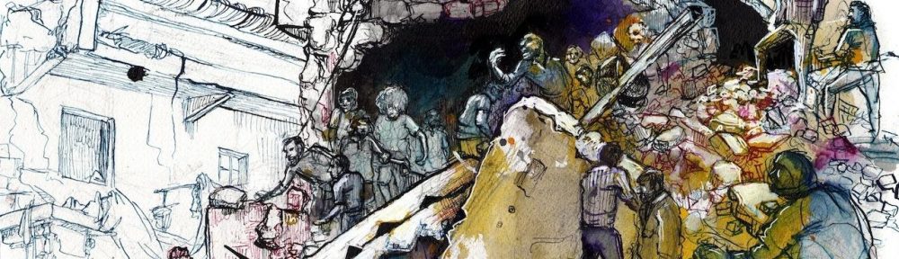
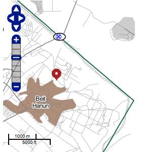
It’s strange how things sometimes come together – or collide and crash.  Two weeks ago I wrote about satellite imagery and ‘remote violence’, and over the summer I discussed several projects that mapped Israel’s military assault on Gaza and its people,  including the Gaza Crisis Atlas produced by the UN’s Office for the Coordination of Humanitarian Affairs (which makes extensive use of hi-res satellite imagery).

The links between those two posts are obvious enough, but today I have something altogether different in my sights.  ‘Judge Dan’ (Dan Smith), who blogs for Israellycool, has used the Gaza Crisis Atlas to construct a series of maps to geo-wash Israel’s military campaign.

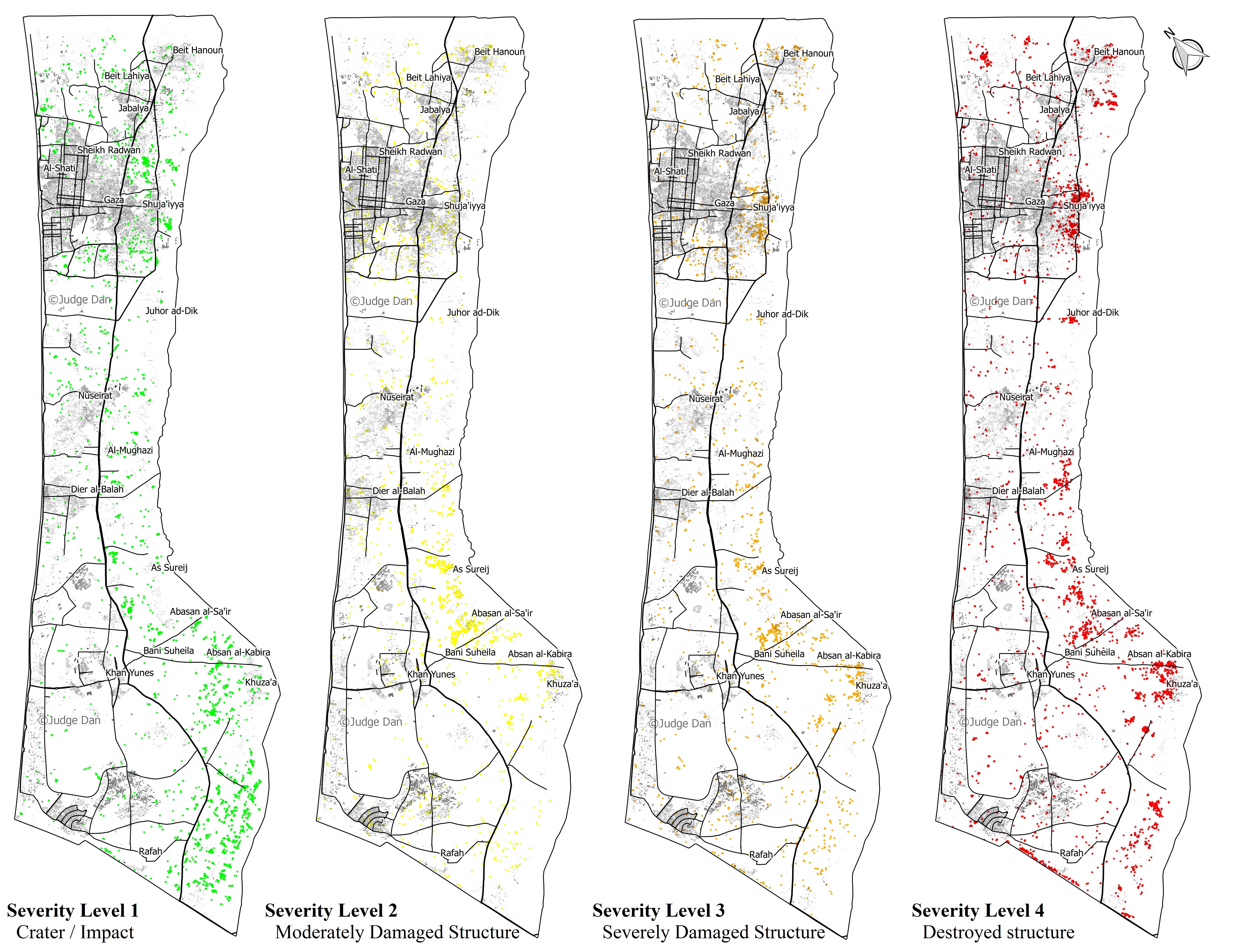
Working from the data in the Atlas, Smith produces four maps to disaggregate the severity of destruction (the four levels, increasing from left to right, are based on OCHA’s own assessment):

DAN SMITH Gaza-Damage-Points-Vertical-All

His conclusions from this exercise are the following:

The attacks are in no way “random” or “indiscriminate”. One can clearly see the spatial distribution of the damage in several aspects. We find 8,952 of the 12,433 total points (72%) are within a 3 KM buffer abutting the border with Israel. The main objective of Operation Protective Edge was to find and destroy dozens of terror tunnels dug from Gaza into Israel.

That the most intensive damage was caused to the area where the tunnels naturally originated is thus perfectly understandable. Furthermore, of the 4,441 destroyed structures, 3,481 of them (78%) are within the 3 KM buffer, as are 2,531 of 3,303 (77%) of the lowest intensity damage (simple craters), which are mostly strikes on rocket launchers and tunnels.

Most of the attacks are grouped around certain neighborhoods or villages, such as Shuja’iyya, Johur ad-Dik, Sureij, and Khuza’a. These were probably the result of the ground operations that took place in dense urban areas also within the 3 KM buffer that housed multiple tunnel entrances and shafts, as well as launch sites for mortars and rockets.

Smith then takes the Israeli military’s map of ‘terrorist infrastructure’ in Shuja’iya and overlays this on what he calls ‘OCHA’s damage points’: ‘the correlation is uncanny.’

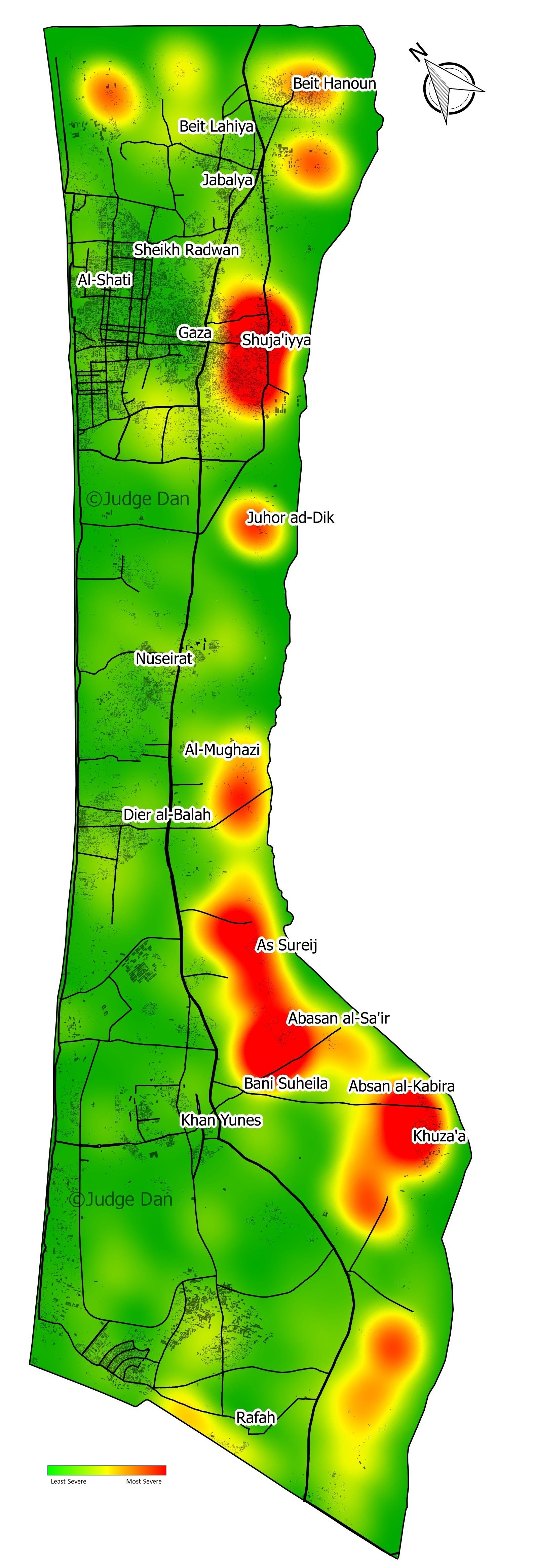
Smith’s next manoeuvre is to sweep aside OCHA’s focus ‘on the civilian aspect’ because it ‘misses the big picture’ (really – or perhaps Israelly): ‘the overall intensity of the strikes’.  So he constructs a kernel density map or a ‘damage intensity heat map’:

It now becomes very clear that most of the damage was caused to 5 locations right on the border with Israel. The rest of the Gaza Strip was, for the most part, undamaged. The main population areas of Gaza city, Jabaliya, Khan Yunes, Rafah and Deir el-Balah were disproportionately undamaged (sic).

DAN SMITH Gaza-Damage-Heatmap-Vertical2

He continues:

If we do a rough estimate of the damage area, it is once again clear the vast majority of the Gaza Strip was unscathed. With a fairly generous estimation that a damage point has a 25 meter radius – the footprint of a house, or the blast radius of a bomb – the total damage area of the 12,433 impacts was in the order of 15 KM2. The land area of the Gaza strip is 360 Km2. In other words, less than 5% of the land was affected.

There’s a follow-up post on ‘damage clusters’ here, but in this commentary I’ll focus on Smith’s ‘big picture’.  I take the basic points to be these:

(1)  Smith’s approach makes an appeal to the supposed objectivity and even facticity of the map (and, by extension, the satellite image), but there is a substantial body of scholarship that goes back 25 years and underscores the multiple ways in which mapping is an exercise in the production of power.  For a depressingly relevant example of the ways in which maps can speak power to truth, taken from Israel’s attack on Gaza in November 2012, see my discussion here (scroll down to the maps).

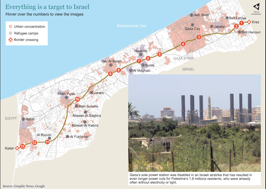
(2)  Appealing to the map and its manipulations as the single source of authority is designed to disavow the testimony of witnesses on the ground: precisely the point sharpened by Andrew Herscher in his timely critique of ‘Surveillant witnessing’ (see my discussion here) and a far cry from the incorporation of photographs in (say) the Gaza War Map.

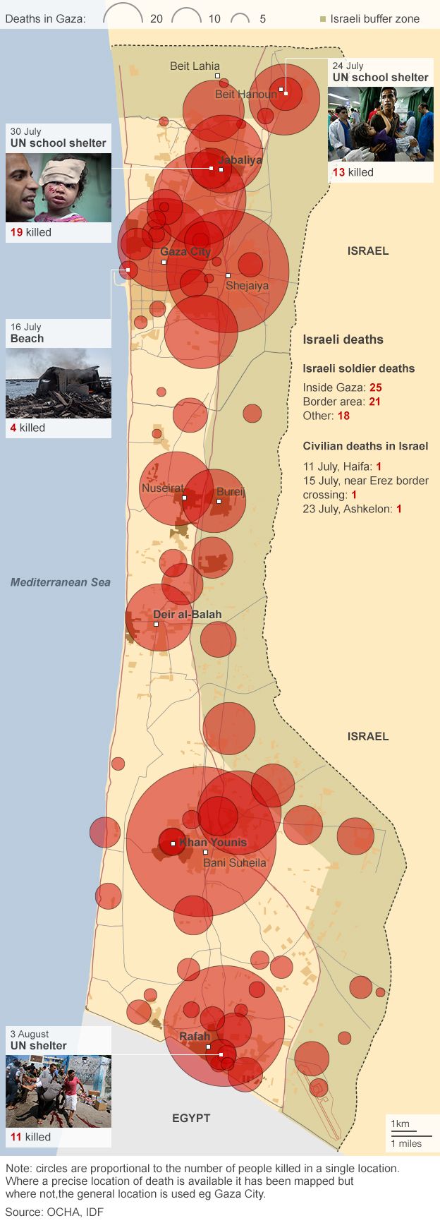
(3) Smith’s methodology reduces Gaza to an object space of structures and buildings, craters and points; he constructs a kernel density map (more on this in a moment) but provides no population density map that would at least gesture towards the people killed, wounded and traumatised by the Israeli offensive and who are wholly absent from his account.  Here, by contrast, is a map I posted previously showing deaths in Gaza to 6 August:

w6401

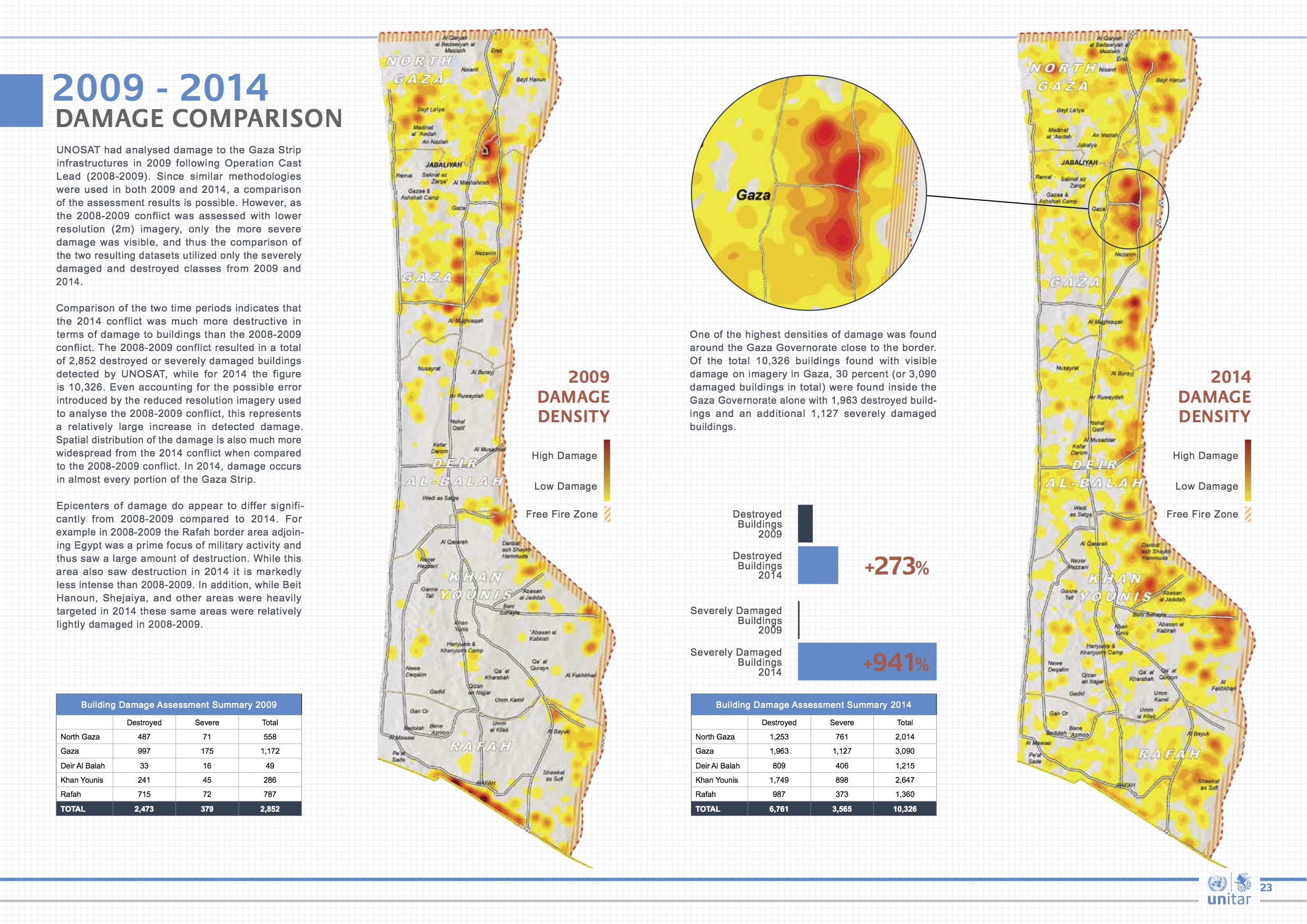
The Gaza Crisis Atlas focuses on damage to buildings and infrastructure because it is a tool directed explicitly towards reconstruction, so the same criticism doesn’t apply (particularly if you look at OCHA’s work more generally, including the information it provided for the map I’ve just reproduced). But if we are to limit ourselves to gazing on structures from space, UNOSAT’s analysis of satellite imagery provides a sharp reminder that these buildings included schools and hospitals (see also here and here); the report also provides a telling comparison between the intensity of destruction in 2009 and 2014:

UNOSAT_GAZA_REPORT_OCT2014_WEB (dragged)

(4) Smith prefers to construct his own generalised map of damage density using kernel density estimation, a smoothing algorithm that converts point data into a continuous surface.  I discussed the way in which the US military uses this technique in ‘Seeing Red’ (DOWNLOADS tab), and what I said there bears repeating:

The maps are known for their dramatic visual impact, and the desired message can be engineered into the production process. One of the most influential handbooks on KDE is published by the US National Institute of Justice and describes how to map crime ‘hot spots’…  The authors of the NIJ handbook acknowledge that ‘map production is an iterative process’ and that ‘the first map produced is very rarely the one presented to the target audience.’ They continue: ‘The intended message should also be seen as the driving force behind what the map should look like’ (US National Institute of Justice, 2005: 26, 33).

So let’s turn to the rest of Smith’s message.

(4) Smith justifies the pattern of destruction shown on his maps by claiming that ‘the main objective of Operation Protective Edge was to find and destroy dozens of terror tunnels dug from Gaza into Israel.’  In fact, the stated objectives of the Israeli assault changed throughout the campaign.  The attacks were supposedly sparked by the kidnapping and murder of three Israeli teenagers – in the West Bank not Gaza – and as the mission was ratcheted up so their central objective changed: according to the IDF the aim was to put an end to Hamas rockets being fired into Israel (for a radically different view, see Graham Liddell‘s more general discussion at Mondoweiss here).  The rhetoric of ‘terror tunnels’ came later.  And while Smith is right to draw attention to the swathes of destruction to the east of Gaza’s central spine, he never addresses the human consequences of successive Israeli expansions of this so-called ‘buffer zone’ until it covered more than 40 per cent of Gaza: see my post here for more details.

(5) Towards the end of his analysis, Smith concedes that destruction is not punctiform.  Bombs are not ‘pinpoints’ (cf. Nathan Guttman‘s report on Smith’s work and ‘the pinpoint accuracy of Israel’s strikes’), not only because they rarely land exactly on target but also because their blast radiates outwards from the point of impact.  But Smith’s ‘fairly generous estimate that a damage point has a 25 meter [82 feet] radius‘ – is in fact a serious underestimate that at the very least halves the blast radius of a 155 mm shell.  Here is Mark Perry‘s report that I cited previously, which includes testimony from senior US military officers about the shelling of Shuj’aiyya:

Artillery pieces used during the operation included a mix of Soltam M71 guns and U.S.-manufactured Paladin M109s (a 155-mm howitzer), each of which can fire three shells per minute. “The only possible reason for doing that is to kill a lot of people in as short a period of time as possible,” said the senior U.S. military officer. “It’s not mowing the lawn,” he added, referring to a popular IDF term for periodic military operations against Hamas in Gaza. “It’s removing the topsoil.”

“Holy bejeezus,” exclaimed retired Lt. Gen. Robert Gard when told the numbers of artillery pieces and rounds fired during the July 21 action. “That rate of fire over that period of time is astonishing. If the figures are even half right, Israel’s response was absolutely disproportionate.” A West Point graduate who is a veteran of two wars and is the chairman of the Center for Arms Control and Non-Proliferation in Washington, D.C., he added that even if Israeli artillery units fired guided munitions, it would have made little difference.

Even the most sophisticated munitions have a circular area of probability, Gard explained, with a certain percentage of shells landing dozens or even hundreds of feet from intended targets. Highly trained artillery commanders know this and compensate for their misses by firing more shells. So if even 10 percent of the shells fired at combatants in Shujaiya landed close to but did not hit their targets — a higher than average rate of accuracy — that would have meant at least 700 lethal shells landing among the civilian population of Shujaiya during the night of July 20 into June 21. And the kill radius of even the most precisely targeted 155-mm shell is 164 feet. Put another way, as Gard said, “precision weapons aren’t all that precise.”

(6) Finally, let’s take Smith’s central claim that ‘less than 5% of the land [of Gaza] was affected’ – and reverse it.  If Hamas were to say that less than 0.00005% of Israel had been hit by its rockets – to be fair, it’s a difficult calculation to make because Israel has never fixed its borders and so it’s not possible to determine its area – and that the rest of Israel was ‘disproportionately undamaged’, would Israelis have simply shrugged them off?


Atlas wept

The Gaza War Map

To grasp the catastrophic scope of destruction in Gaza, there are three new resources of exceptional importance.  First, Lewis Whyld‘s The Gaza War Map: it’s an interactive map keyed to a series of panoramic images which transports you to 20 sites from Beit Hanoun south to Rafeh and it is, appropriately, devastating.

Gaza Crisis Atlas

Second, the UN’s Office for the Coordination of Humanitarian Affairs has released its Gaza Crisis Atlas: 110 pages of maps and high-resolution satellite imagery.  It’s a remarkably systematic survey, whose primary purpose is to assist aid and development agencies in planning and responding to the crisis, but it’s also an indispensable resource for anyone wanting to grasp the intensity of the prolonged Israeli assault on Gaza and its people.  The text and captions are available in eight languages, and you can zoom and print individual pages.

Finally, there’s MediaTown‘s drone-shot video of the destruction of Al-Shejaiya; its brevity does not sacrifice its impact:

Even hardened US military officers were stunned by the unrelenting and indiscriminate nature of the bombardment.  Throughout the offensive the Pentagon compiled reports twice a day on Israeli military operations, and according to a summary of the barrage on 20-21 July ’11 Israeli artillery battalions …  pumped at least 7,000 high explosive shells into the Gaza neighborhood, which included a barrage of some 4,800 shells during a seven-hour period at the height of the operation…’

That amounts to shelling Al-Shejaiya every six seconds FOR SEVEN HOURS (more from Kerry-anne Mendoza among the ruins of Al-Shejaiya here, and more imagery from Occupied Palestine here).

Al-Jazeera reports:

“Eleven battalions of IDF artillery is equivalent to the artillery we deploy to support two divisions of U.S. infantry,” a senior Pentagon officer with access to the daily briefings said. “That’s a massive amount of firepower, and it’s absolutely deadly.” Another officer, a retired artillery commander who served in Iraq, said the Pentagon’s assessment might well have underestimated the firepower the IDF brought to bear on Shujaiya. “This is the equivalent of the artillery we deploy to support a full corps,” he said. “It’s just a huge number of weapons.”

Artillery pieces used during the operation included a mix of Soltam M71 guns and U.S.-manufactured Paladin M109s (a 155-mm howitzer), each of which can fire three shells per minute. “The only possible reason for doing that is to kill a lot of people in as short a period of time as possible,” said the senior U.S. military officer. “It’s not mowing the lawn,” he added, referring to a popular IDF term for periodic military operations against Hamas in Gaza. “It’s removing the topsoil.”

“Holy bejeezus,” exclaimed retired Lt. Gen. Robert Gard when told the numbers of artillery pieces and rounds fired during the July 21 action. “That rate of fire over that period of time is astonishing. If the figures are even half right, Israel’s response was absolutely disproportionate.” A West Point graduate who is a veteran of two wars and is the chairman of the Center for Arms Control and Non-Proliferation in Washington, D.C., he added that even if Israeli artillery units fired guided munitions, it would have made little difference.’

Before I let Gard continue, it’s important to remember that the onslaught did not end that night.  Here is a remarkable video which shows the shelling of Shejaiya market on 30 July (more updates and images from #shejaia here).  Imagery of Shejaiya before and after the bombardment was distributed to Israeli soldiers in Brigade 828 as ‘a victory momento‘ and spur to maintain their ‘fighting spirit’.

Gard goes on to explain the circular error probable (CEP) of munitions and the blast and fragmentation or ‘kill radius’, which I’ve discussed here (scroll down for the ‘kill radius’):

Even the most sophisticated munitions have a circular area of probability, Gard explained, with a certain percentage of shells landing dozens or even hundreds of feet from intended targets. Highly trained artillery commanders know this and compensate for their misses by firing more shells. So if even 10 percent of the shells fired at combatants in Shujaiya landed close to but did not hit their targets — a higher than average rate of accuracy — that would have meant at least 700 lethal shells landing among the civilian population of Shujaiya during the night of July 20 into June 21. And the kill radius of even the most precisely targeted 155-mm shell is 164 feet. Put another way, as Gard said, “precision weapons aren’t all that precise.”

Senior U.S. officers who are familiar with the battle and Israeli artillery operations, which are modeled on U.S. doctrine, assessed that, given that rate of artillery fire into Shujaiya, IDF commanders were not precisely targeting Palestinian military formations as much as laying down an indiscriminate barrage aimed at cratering the neighborhood. The cratering operation was designed to collapse the Hamas tunnels discovered when IDF ground units came under fire in the neighborhood. Initially, said the senior Pentagon officer, Israel’s artillery used “suppressing fire to protect their forward units but then poured in everything they had, in a kind of walking barrage. Suppressing fire is perfectly defensible. A walking barrage isn’t.”

The implication of those closing remarks is that such an indiscriminate barrage is a clear violation of international humanitarian law: and the epic scale of that violation is made clear in the maps, imagery and video I’ve cited here.  It also amounts to collective punishment of a whole community, so it comes as no surprise to discover that the Israeli Supreme Court (‘sitting as the High Court of Justice’ – a phrase that has the same moral resonance as the Israeli Defence Force) has recently endorsed the ‘deterrent function’ of collective punishment (even though it too is prohibited under international humanitarian law).  But even the Court insisted that such a measure had to be ‘proportionate’.

All of this is much on my mind as I head to a meeting in Oulu, Finland, where I’ll be talking about ‘Trans-border transgressions: legal geographies and spaces of exception’.   The case studies on which I’ll draw are the Federally Administered Tribal Areas of Pakistan (mainly Waziristan) and Gaza.  More soon.

Destructive Edge

In a previous post on ‘The Death Zone‘, I suggested readers compare Israel’s extended ‘buffer zone’ in Gaza by following the line of the main highway, Saladin Street.  Hugh Naylor has followed that route on the ground – what he calls ‘Desolation Road’ – and his report is accompanied by an interactive map showing some of the vast panorama of destruction:

Screen Shot 2014-08-08 at 10.01.01

I’ll have more to say about the caption – about the Israeli military’s targeting in Gaza – shortly.  The Guardian has just published a graphic by Nadja Popovich showing the UNRWA-run schools sheltering refugees (many of them from the expanded ‘buffer zone’) that were struck by the Israeli military:

Gaza schools hit by Israeli military

 Amnesty International reports growing evidence that health facilities and workers were deliberately targeted by the Israeli military:

Testimonies from doctors, nurses, and ambulance workers who have spoken to Amnesty International paint a disturbing picture of hospitals and health professionals coming under attack by the Israeli army in the Gaza Strip, where at least six medics have been killed. There is growing evidence that health facilities or professionals have been targeted in some cases.

Since Israel launched Operation “Protective Edge” on 8 July, the Gaza Strip has been under intensive bombardment from the air, land and sea, severely affecting the civilian population there. As of 5 August, according to the UN Office for the Coordination of Humanitarian Affairs, 1,814 Palestinians had been killed in the Gaza Strip, 86 per cent of them civilians. More than 9,400 people have been injured, many of them seriously. An estimated 485,000 people across the Gaza Strip have been displaced, and many of them are taking refuge in hospitals and schools.

Amnesty International has received reports that the Israeli army has repeatedly fired at clearly marked ambulances with flashing emergency lights and paramedics wearing recognizable fluorescent vests while carrying out their duties. According to the Palestinian Ministry of Health, at least six ambulance workers, and at least 13 other aid workers, have been killed as they attempted to rescue the wounded and collect the dead. At least 49 doctors, nurses and paramedics have been injured by such attacks; at least 33 other aid workers were also injured. At least five hospitals and 34 clinics have been forced to shut down due to damage from Israeli fire or continuing hostilities in the immediate area.

Hospitals across the Gaza Strip suffer from fuel and power shortages (worsened by the Israeli attack on Gaza’s only power plant on 29 July), inadequate water supply, and shortages of essential drugs and medical equipment. The situation was acute before the current hostilities, due to Israel’s seven-year blockade of Gaza, but have been seriously exacerbated since…

Amnesty International is aware of reports that Palestinian armed groups have fired indiscriminate rockets from near hospitals or health facilities, or otherwise used these facilities or areas for military purposes. Amnesty International has not been able to confirm any of these reports. While the use of medical facilities for military purposes is a severe violation of international humanitarian law, hospitals, ambulances and medical facilities are protected and their civilian status must be presumed. Israeli attacks near such facilities – like all other attacks during the hostilities – must comply with all relevant rules of international humanitarian law, including the obligation to distinguish between civilians and civilian objects and military targets, the obligation that attacks must be proportional and the obligation to give effective warning. Hospitals and medical facilities must never be forced to evacuate patients under fire.

20140801_ambulance_520

The report includes detailed testimony from Palestinian paramedics and ambulance crews who describe the extraordinary difficulty and danger they faced in attending to casualties from Israeli shelling (see also my post on ‘Gaza 101‘, the emergency number for Gaza, and the update here).  Not surprisingly, Israel has rejected Amnesty’s claims and denied targeting hospitals, but when Netanyahu’s spokesperson, Mark Regev, explained that ‘What we’ve had to do on a number of occasions is to hit terrorist targets in the immediate vicinity of hospitals and things like that, where they’ve abused them,’ he failed to address the violations of international law summarised in the last paragraph above.

There’s more.  B’Tselem, now back on line, is also providing detailed testimony from Gaza, including (so far) two ambulance drivers, Rami ‘Abd al-Haj ‘Ali and Ahmad Sabah.  Here is an extract from the first statement (all testimonies are linked to B’Tselem’s interactive map):

B'Tselem map Beit HanounOn Friday afternoon, 25 July 2014, I was working at the medical emergency call center in Beit Hanoun. At around 4:30 P.M., we received a call reporting injured people in al-Masriyin Street in Beit Hanoun. We asked the International Red Cross to coordinate our going there. About 15 minutes after we received the call, we got authorization and an ambulance headed over there with paramedics ‘Aaed al-Bura’i, 25, Hatem Shahin, 38, and driver Jawad Bdeir, 52. The team didn’t make it to the wounded people. Soon after they reached the street, they reported back that a tank had fired at them and they were injured. They asked for another team to come and rescue them.

The call center coordinated the arrival of another team with the International Red Cross and got authorization to go rescue the injured team. I drove the second ambulance, and there were two medics with me – Muhammad Harb, 31, and Yusri al-Masri, 54. The street is only about 200-300 meters from the call center, so we were there within minutes. When we reached the entrance to the street, we were surprised to see three tanks and a military bulldozer in the street, about 100 meters away.

Suddenly, with no warning, they opened heavy machine-gun fire at us. The bullets penetrated the ambulance. I tried to turn the ambulance around to get out of there, but the steering wheel must have been hit. Suddenly, I felt sharp pain in my leg and realized I’d been hit by a bullet or shrapnel. Then the windshield shattered. Because I couldn’t turn the ambulance around, I decided to try reversing. They kept firing as I backed up, until we got far enough away. When they stopped, I managed to turn us around and head back to the center.

On the way there we met Hatem Shahin, one of the paramedics from the first ambulance. He’d been hit by shrapnel in his shoulder and leg. He told us that a shell fired from a tank had hit the front part of the ambulance. He said he’d managed to get away but the other paramedic, ‘Aaed, had been hit. He told us that after he ran away from there, he saw the tank fire another shell at the ambulance, completely destroying it. He thought ‘Aaed must have been killed, but we didn’t know for sure.

The next day, on Saturday, a ceasefire was declared from 8:00 A.M. to 8:00 P.M. An ambulance team went to the spot and found ‘Aaed’s body in the burnt ambulance.

To put all of this in context, the BBC has mapped the deaths of 1,890 Palestinians – ‘mostly civilians’, as its accompanying chart shows – killed during the Israeli offensive to 6 August.  As you can see, Palestinians were killed ‘right across Gaza’ – not only in the expanded buffer zone shown on the map, though the carnage in Beit Hanoun and Shejaiya is clearly visible – with high concentrations also produced in the killing grounds of Gaza City and Khan Younis:

w640

Finally, in case you’re puzzled by the title for this post: Israel’s attack on Gaza is codenamed Tzuk Eitan in Hebrew, meaning ‘Firm Cliff’ or ‘Resolute Cliff’.  According to Yagiv Levy, ‘The operation’s name signals the power, commitment and resilience of the Israeli people.’  But the official English-language version, ‘Protective Edge’, was changed ‘to give it a more defensive connotation’ (really). As Steven Poole explains, ‘the bombing was supposedly “protective”, though not of those bombed’. All of this is of course in line with the designation of the Israeli military as the ‘Israeli Defence Forces’.

I decided I’d prefer to use a version that provides a more accurate rendering of what has happened – in Hebrew, English or Arabic.

Mapping Aleppo – and more

Mapping Aleppo

I’ve posted about mapping the war in Syria and its spillover effects before (see here and here), but most of these projects cover a wide area with varying degrees of reliability.  Now News from Laleh Khalili of a report from David Kilcullen‘s Caerus Associates (with the American Security Project) on the civil war in Aleppo, “Mapping the conflict in Aleppo, Syria”, which provides a much more fine-grained view of what is happening on the ground.  You can download the report here or view the interactive version via First Mile Geo here, and you can read an account of the project from Wired‘s Greg Miller here.

Caerus has also joined with the Pentagon’s Center for Complex Operations to produce a special supplement of PRISM (vol.  4, 2014) on the Syrian conflict, which includes an essay by Kilcullen and Nathaniel Rosenblatt on ‘The Rise of Syria’s Urban Poor: Why the War for Syria’s Future Will Be Fought Over the Country’s New Urban Villages’; the whole issue is available on open access here.

These interventions are important and interesting for several reasons.

First, the report is based on exacting local fieldwork.  Acknowledging that local people in conflict zones develop vitally important stocks of local knowledge as a means of survival, the report also accepts that this ‘information-rich environment remains analytically poor.’  For that reason, the field teams ‘provided training and cloud-based tools to help local actors collect locally understood knowledge about their conflict for rigorous analysis.’

From September 16, 2013 to January 6, 2014, we collected four types of information: a monthly survey of perceptions among 560 residents in Aleppo’s 56 neighborhoods, biweekly location and status data for bakeries (a key indicator of humanitarian conditions due to the centrality of bread in the Syrian diet), biweekly location and status data on security checkpoints (a key indicator of security, territorial control and public safety conditions), and a monthly neighborhood-level assessment filled out by our enumerators. These four data streams not only allowed the research team to detect and visualize shifts in the environment in near-real time, but also provided an extremely rich source of insights on the geo-social dynamics at play. All field research was conducted in Arabic.

First Mile Geo notes that it will make the data available to organisations ‘for responsible use’: see Open Data here.

KILCULLEN Out of the mountainsSecond, Kilcullen’s analytical argument (he is described as ‘Principal Investigator’ for the Mapping project) is, naturally enough, fully conformable with the thesis he develops at length in his latest book, Out of the mountains: the coming age of the urban guerrilla (2013); the report reveals the grisly details of contemporary siege warfare and urbicide – central themes in the book, where Kilcullen notes the work of  Steve Graham and Eyal Weizman – and gestures towards a future ‘feral city’ (how I hate that phrase) broken into multiple fiefdoms where gangs and militias exact violence and provide rudimentary services to the residents:

‘The inability of opposition groups to aid residents of neighborhoods they control suggests Aleppo – and Syria as a whole – will become a mosaic of small, intersecting fiefdoms, each providing assistance to its respective neighborhood without regard to macro-level concerns for national governance and reconciliation. Growing warlordism may be particularly acute in Aleppo, where economic rent-seeking opportunities will attract armed gangs who will attempt to seize control of its neighborhoods. These “conflict entrepreneurs” will have little incentive to end a conflict from which they derive power, prestige, and profit. Even in the event of peace, Aleppo’s strategic location will help these actors establish roots for illicit networks that may endure well beyond the present conflict. Moreover, as a non-capital city, Aleppo will not benefit from national government attention. Instead, Aleppo’s future may resemble that of similarly conflict-plagued second cities in the Middle East, such as Mosul in Iraq or Benghazi in Libya. These cities are plagued by warlordism and dominated by illicit economies. They have quickly become safe havens enabling terrorist networks to plan, recruit, and launch attacks.’ 

I’ve posted about Out of the Mountains here, when I promised an extended commentary: Laleh and I will be working on a joint examination of Kilcullen’s larger thesis in the near future, so watch this space. We already have Mike Davis‘s thumbnail view:

‘Although an enemy of the state, I must concede that this is a brilliant book by the most unfettered and analytically acute mind in the military intelligentsia. Kilcullen unflinchingly confronts the nightmare of endless warfare in the slums of the world.’

Here, incidentally, it’s revealing to read Kilcullen’s theses alongside Neil Brenner‘s ‘Theses on urbanisation’, Public culture 25:1 (2013) 85-114, which makes a series of suggestive proposals – but from which war is strikingly absent.  So Kilcullen’s thesis certainly demands serious scrutiny, particularly by those who think that the future of war is somehow encapsulated in the drone.  In my previous note, I joined Geoff Manaugh in being sceptical about the ‘aerial-algorithmic’ interventions that attracted Kilcullen in a series of talks based around the book, but ‘Mapping the conflict in Aleppo’ reveals a much more substantial interest in ‘the facts on the ground’, local actors and local knowledge.  (And here a good counter-text would be the brilliant work of AbdouMaliq Simone; see also his blog, Villes-Noires, here).  So, as I say, watch this space.

First Mile Geo ALEPPO

But there’s a third reason this matters.  I’ve been reading and thinking about Jeremy Crampton, Sue Roberts and Ate Poorhuis‘s ‘The new political economy of geographical intelligence’ – a fine essay in the Annals of the Association of American Geographers 104: 1 (2014) 196-214 – and I’ll be returning to this in the next day or two.  They emphasise the importance of satellite imagery in the production of US geospatial intelligence, whereas I’ve been developing a different (though related) argument about  the importance of satellite communications for the ‘everywhere war’.  In both cases, there is an intimate relation between ‘milsat’ and ‘comsat’, the military and commercial sectors, which will come as no surprise to those who’ve been plotting the extending contours of the military-industrial complex.

Those contours have snared all sorts of other institutions, of course, which is why James Der Derian talks about MIME-NET (the military-industrial-media-entertainment network) and I’ve talked about MAIM-NET (the military-academic-industrial-media network).  The role of universities in the development of military capabilities and military knowledge (and ultimately the production of military violence) is no less surprising, of course, and in fact there’s a session on ‘Geography and the military’ organised by Eric Sheppard at the AAG conference in Tampa (an appropriate location for several reasons) to debate these issues.  But it should now be clear that the production of these geographical knowledges is not confined to the military and civilian intelligence agencies, the academy and large corporations but also includes a host of much smaller private contractors devoted to ‘geographical intelligence’.  They come in different shapes and sizes, and with different agendas.  Caerus, for example, describes itself as a ‘strategy and design firm’ that helps clients ‘understand and thrive in complex, conflict-afflicted, and disaster-affected environments’.  But there are many others, and it’s important not to lose sight of their role in what the US military would call ‘shaping the battlespace’…