Googling military occupation

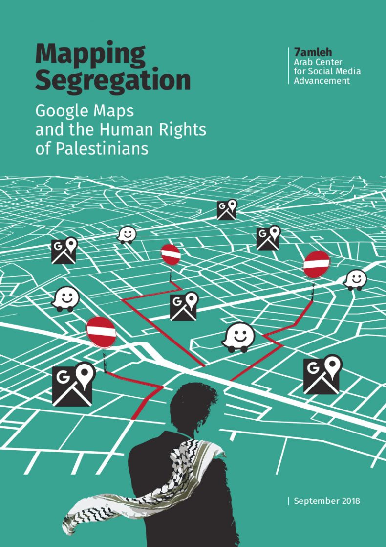
A new report from the Arab Center for Social Media Advancement, Mapping Segregation: Google Maps and the Human Rights of Palestinians, adds another dimension to contemporary discussions about the weaponisation of social media (and, not incidentally, about Google’s claims of social responsibility).

The report outlines the restrictions imposed by the illegal Israeli occupation of the West Bank on Palestinians, and compares three cartographic apps: Google Maps, Maps.me and Waze.  The focus is on what is missing from their digital maps – the misrepresentation or erasure of Palestinian villages (though illegal Israeli colonies are clearly marked) – and the cartographic attenuation of the all-too-real restrictions on the movement of Palestinians.  For example:

On routes within the West Bank, Google Maps prioritizes directing users through Israel rather than through the West Bank, even if this adds considerable distance to the journey. The drive from Ramallah to Nablus through the West Bank usually takes 45 minutes, however when using Google Maps, the journey takes a long route through Israel and takes 4.5 hours. In contrast, the shortest route from Ramallah to Bethlehem takes the driver through Jerusalem, which is inaccessible for Palestinian West Bank ID holders. Whenever a route passes through the West Bank, Google Maps shows two warnings on the route description: “This route has restricted usage or private roads” and “This route may cross country borders” and fails to highlight Israeli settlements or checkpoints. Google Maps is unable to calculate routes within Palestinian rural communities, or to and from Gaza, displaying the message “Sorry, we could not calculate driving/walking directions from x to y”. The app offers the option to “add a missing place” and edit information, but this “might take some time to show up on the map” as they must be reviewed first.

More from +972 magazine here.

If you haven’t done this before, try putting “Palestine” into the search box on Google Maps: the report discusses that too.

Military, media and (im)mobilities

Two important new books on Israel’s occupation of Palestine that both have even wider implications.

First, Adi Kuntsman and Rebecca Stein on Digital militarism: Israel’s occupation in the social media age from Stanford University Press:

pid_23022Israel’s occupation has been transformed in the social media age. Over the last decade, military rule in the Palestinian territories grew more bloody and entrenched. In the same period, Israelis became some of the world’s most active social media users. In Israel today, violent politics are interwoven with global networking practices, protocols, and aesthetics. Israeli soldiers carry smartphones into the field of military operations, sharing mobile uploads in real-time. Official Israeli military spokesmen announce wars on Twitter. And civilians encounter state violence first on their newsfeeds and mobile screens.

Across the globe, the ordinary tools of social networking have become indispensable instruments of warfare and violent conflict. This book traces the rise of Israeli digital militarism in this global context—both the reach of social media into Israeli military theaters and the occupation’s impact on everyday Israeli social media culture. Today, social media functions as a crucial theater in which the Israeli military occupation is supported and sustained.

Here is Laleh Khalili on the book:

“Amidst the hype of Facebook revolutions and the ostensible democratizing power of social media, Adi Kuntsman and Rebecca Stein illuminate the counterpoint: online militarization and the extension of state politics into the virtual realm. They expose the machinery of the Israeli state power at work within social media, and show the possibilities for countering the force of this machinery. Powerfully argued, beautifully researched, and thought-provoking, Digital Militarism is vitally important.”

Second, Hagar Kotef‘s Movement and the Ordering of Freedom: On Liberal Governances of Mobility from Duke University Press:

KOTEF Movement and the ordering of freedomWe live within political systems that increasingly seek to control movement, organized around both the desire and ability to determine who is permitted to enter what sorts of spaces, from gated communities to nation-states. In Movement and the Ordering of Freedom, Hagar Kotef examines the roles of mobility and immobility in the history of political thought and the structuring of political spaces. Ranging from the writings of Locke, Hobbes, and Mill to the sophisticated technologies of control that circumscribe the lives of Palestinians in the Occupied West Bank, this book shows how concepts of freedom, security, and violence take form and find justification via “regimes of movement.” Kotef traces contemporary structures of global (im)mobility and resistance to the schism in liberal political theory, which embodied the idea of “liberty” in movement while simultaneously regulating mobility according to a racial, classed, and gendered matrix of exclusions.

And here is Eyal Weizman on this one:

“In this book Hagar Kotef manages to successfully weave several intellectual projects: a wide-ranging and theoretically sophisticated contribution to political theory, a robust and fine-grained analysis of the mechanisms of Israeli control of Palestinian movement, and a direct confrontation with its injustice. This book is a major contribution to the topological shift in the study of space. Kotef does nothing less than rewrite the history of territory as a matter of movement, and that of sovereignty as the control of matter in movement. By pushing her original insight as far as it would go, she best captures the logic of the world we struggle to live within.”

You can read the introduction on Scribd.

Bethlehem to Baghdad

In 2008 the artist Till Roeskens – who describes himself as an ‘amateur of applied geography’ – produced a ‘videocartography’ or ‘videomapping’ based on interviews at the Aida refugee camp in occupied Palestine.  Roeskens explains: ‘I asked residents of the camp to draw with big ink pens so the marks would go through the paper. I filmed from the other side, as they drew, so I didn’t see the person while they were drawing and speaking; I saw only the white screen with the light coming from behind me.’  The mappings, together with the stories told by those who drew them, were recorded on video, and ‘as the film progresses, the viewer is increasingly hemmed in by a complex network of lines, until the reality of the occupation is fully realized on screen’.      There is a revealing interview with the artist at Words without borders here, and you can watch some extracts here (and there are others on YouTube and vimeo).

« On screen: nothing but another screen. At first untouched, a blank sheet of paper is slowly being filled with more or less straight lines. Then these lines grow, push and cross each other, to finally form a drawing, a layout; they unfold a topography, mark places, build houses, give directions, describe in great detail tangles of roads and obstacles. In fact, they are laying down flat biographies. Six sheets slowly come to life that way, one after another, following the rhythm of stories told by children, women or men voices, of people we never get to see. Where are these voices? Behind the sheets. Of course, but where else? Nowhere: that is precisely what the voices are trying to say. Or rather, because even nowhere persists on taking up some space, they say that they are in Palestine. (…) »

Inspired by Rosekens’ work, Antonio Ottomannelli transposed the technique to Baghdad.  The project was carried out between November 2011 and February 2012 with students at the Fine Arts Faculty of the University of Baghdad.  Ottomannelli:

‘Baghdad is a hidden city.  Everything is placed behind anti-explosion walls, from one checkpoint to the next. … The latest map of Baghdad was made by the US military in 2003 for military and strategic purposes…  There is no civilian map of the current configuration… Inspired by the work of Till Roeskens on Palestine, Mapping Identity tries to tell about the city – the whole of it – from the inside.  A snapshot of the ordinary, a minor “Giacometti portrait”, as Baghdad is concealed…’

More details here, and a videomap here (more on vimeo).

These projects are political-artistic versions of the ‘mental maps’ that captured the imagination of many human geographers in the 1960s and 70s – an interest which is usually traced back to Kevin Lynch’s experiments with The image of the city (1960) and that probably climaxed in Peter Gould and Rodney White’s classic little book, Mental maps, originally published in 1974 – but what makes these projects so compelling is their emphasis on the process of mapping (through their use of video) rather than a fixation on the map as finished object.  One of the criticisms of the original ‘mental mapping’ projects was that respondents drew maps only because they were asked to: that this was not how people found their way around their neighbourhoods, which usually turned out to be a much more pragmatic, improvisational practice responding to cues and following routines rather than relying on some imaginary point of overview.  But these two projects are ways of narrating a space – of telling what Michel de Certeau would call ‘spatial stories’ – that are also interventions in (and subversions of) larger narratives of military violence and military occupation.