Googling military occupation

A new report from the Arab Center for Social Media Advancement, Mapping Segregation: Google Maps and the Human Rights of Palestinians, adds another dimension to contemporary discussions about the weaponisation of social media (and, not incidentally, about Google’s claims of social responsibility).

The report outlines the restrictions imposed by the illegal Israeli occupation of the West Bank on Palestinians, and compares three cartographic apps: Google Maps, Maps.me and Waze.  The focus is on what is missing from their digital maps – the misrepresentation or erasure of Palestinian villages (though illegal Israeli colonies are clearly marked) – and the cartographic attenuation of the all-too-real restrictions on the movement of Palestinians.  For example:

On routes within the West Bank, Google Maps prioritizes directing users through Israel rather than through the West Bank, even if this adds considerable distance to the journey. The drive from Ramallah to Nablus through the West Bank usually takes 45 minutes, however when using Google Maps, the journey takes a long route through Israel and takes 4.5 hours. In contrast, the shortest route from Ramallah to Bethlehem takes the driver through Jerusalem, which is inaccessible for Palestinian West Bank ID holders. Whenever a route passes through the West Bank, Google Maps shows two warnings on the route description: “This route has restricted usage or private roads” and “This route may cross country borders” and fails to highlight Israeli settlements or checkpoints. Google Maps is unable to calculate routes within Palestinian rural communities, or to and from Gaza, displaying the message “Sorry, we could not calculate driving/walking directions from x to y”. The app offers the option to “add a missing place” and edit information, but this “might take some time to show up on the map” as they must be reviewed first.

More from +972 magazine here.

If you haven’t done this before, try putting “Palestine” into the search box on Google Maps: the report discusses that too.

Conflicts without borders

In Finland last month I gave a presentation on Law, violence and b/ordering, in which I began by making two preliminary points about border crossings and (para)military violence: trans-border incursions and transgressions have been facilitated by (i) new stealth technologies deployed by state actors and (ii)  the rise of new non-state and para-state actors.  Here are the relevant slides:

GREGORY 2 Law, violence and b:ordering.001

GREGORY 2 Law, violence and b:ordering.002

GREGORY 2 Law, violence and b:ordering.003

GREGORY Law, violence and b:ordering.003

I derived the map showing the advance of IS(IS)/ISIL from the Institute for the Study of War; say what you like about their politics (this is the Kagans we are talking about), their maps and summaries are extremely helpful.

Now Public Intelligence has just published a series of (unclassified) maps of Iraq, Syria, Lebanon and Jordan produced by the Humanitarian Information Unit of the US State Department called Conflicts Without Borders:

‘Conflicts Without Borders refers to a conflict in one country that draws in other governments and non-state actors, exacerbates stresses and conflicts in the neighbouring countries, and generates displacement across borders.’

That’s a definition to think about; there are obvious ironies in the US offering a definition that I suspect is intended to exclude its own part in initiating conflicts (if so, it doesn’t work), and there is the interesting attribution of causal powers to conflicts (which ‘draw in’ other actors like so many black holes).

This map series is dated 9 October 2014; the maps provide a Regional Overview (the first map below) and then show Northern Syria and Turkey, Western Syria and Lebanon, Southern Syria and Jordan and Eastern Syria and Iraq (the second map below).

DoS-Syria-ISIL

DoS-Iraq and Syria-ISIL

You can access a single summary map for late June here (shown below):

DoS Iraq Syria Conflict June 2014

Maps of/for pain

This morning I received a copy of Jess Bier‘s recently completed PhD thesis, Mapping Israel, Mapping Palestine (Technology and Science Studies, Maastricht, 2014) – thanks so much, Jess – and I look forward to working my way through it.  You can download a version from Academia here.


BIER Mapping Israel, mapping Palestine

Here is the abstract:

Mapping Israel, Mapping Palestine is an analysis of the ways that segregated landscapes have shaped the practice of cartography in Jerusalem and the West Bank since 1967. Extending work on how technology is socially constructed, it investigates the ways that knowledge is geographically produced. Technoscientific practices are situated in spatial contexts which are at once both social and material. This situated character influences the content of knowledge in ways that can be unpredictable. Therefore, it is necessary to reflexively engage with materiality in order to enable landscapes that allow for more diverse practices and forms of knowledge.

The complex geographies of Palestine and Israel provide central sites for the study of how landscapes shape the form, content, and circulation of knowledge. 1967 marks the beginning of the Israeli Occupation of the Palestinian Territories, including the West Bank and Gaza Strip. With the notable exception of East Jerusalem, currently most of the occupied areas have been neither formally incorporated into the Israeli state, nor have they been allowed to form an independent sovereign nation. Instead, small pockets of Palestinian control have been carved out through a series of international negotiations aimed at clearly defining separate states for Palestinians and Israelis—negotiations which often take place over tables strewn with maps.

Yet even as maps are employed in attempts to end the Occupation, similar methods have been used to build intricate infrastructure networks for curtailing human movement within the Territories. These include the 8‐meter [high] Wall which snakes through the West Bank, segregated sets of roads and buildings, as well as roving series of checkpoints and roadblocks, all designed with the purpose of confining Palestinians and separating them from Israelis. The planning, construction, and administration of such systems of control are made possible by the same Geographic Information Science (GIS) mapmaking practices which are used in attempts to ameliorate the conflict. To understand how this is possible, it is necessary to explore the ways that such practices are differently incorporated throughout the very region which cartographers seek to map and reshape.

The centrality of maps to debates over the future of Palestine and Israel has only intensified since the advent of digital cartography has led to increasingly minute forms of surveillance and control. Contemporary cartography incorporates a range of practices in Jerusalem and the West Bank, from adaptations of decommissioned spy satellite images to a road map made by Palestinian students who tracked their own movements on their mobile phones. Intended to display objective facts, empirical maps often inspire extensive discussion. Participants in these discussions exhibit a variety of observational frames that cannot be divorced from their unequal positions and mobilities within the very terrains that they seek to portray. Mapping Israel, Mapping Palestine addresses these issues by presenting an analysis of the empirical maps and mapmaking practices which result when diverse cartographers travel to chart the same landscapes that so condition their movement. As such, it investigates the myriad ways that the segregated landscapes of the Israeli Occupation shape the conditions of possibility for knowledge about the Occupation and its effects.

This is really important work (see also the presentation by the Foundation for Middle East Peace here), but in addition to maps and digital captures of occupied Palestine – the plethora of lines on maps – there are other operational dimensions to mapping.  I’m thinking in particular of the IDF’s target maps.  You can find a report of its ‘target bank’ for southern Lebanon in 2011 here – ‘many time larger than it was in 2006’ – and Craig Jones‘s discussion of surveillance, imagery and targeted killing here.

This apparatus is in full play during the present military offensive on Gaza, which (like all the others) involves the production and destruction of targets through the mobilisation of cartography.

But there are other dimensions.  Here is a senior IDF officer, as reported by Reuters on 12 July:

“We are dealing with a variety of families of targets. If there is a kind of a map, or a map of pain that the enemy sees, we create a lot of pain so that he will have to think first to stop the conflict.”

There may well be a map of pain — but the pain is also produced through mapping.

‘The land of rotting men’

No man's land

Noam Leshem and Alasdair Pinkerton have embarked on a fascinating new project, Re-inhabiting No Man’s Land: from dead zones to living spaces here:

Nearing the centenary of the First World War, this project explores the ongoing relevance of no-man’s lands in the 21st century. Rather than merely empty, divisive spaces, the project considers the material substance of no-man’s lands, their changing social-cultural meaning and their relevance as productive political and geopolitical spaces.

As a figure of speech, No-Man’s Land is applied to anywhere from derelict inner-city districts and buffer-zones to ‘ungovernable’ regions and tax havens. But what is no-man’s land? What are the conditions that produce it? How is it administered? What sort of human activities do no-man’s lands harbour? These are the questions that prompt us to think about the no-man’s lands not as dead zones, but as living spaces.

WWI consulting a map

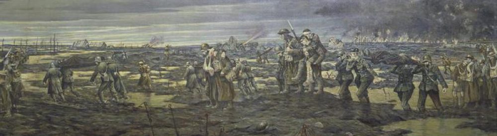
News of this arrived from Noam just as I finished the long-form version of Gabriel’s Map: cartography and corpography in modern war, which you can now find under the DOWNLOADS tab (scroll down).  Most of the essay is about the First World War on the Western Front (I explain the title at the start of the essay; it comes from William Boyd‘s Ice-Cream War and, in particular, the First World War in East Africa, and the title of this post comes from Edward Lynch‘s Somme Mud: the experiences of an infantryman in France, 1916-1919), but I also end with these reflections on the 21st century:

In this essay I have been concerned with the First World War but, as we approach its centenary, it is worth reflecting on the ways in which modern warfare has changed – and those in which it has not. Through the constant circulation of military imagery and its ghosting in video games, many of us have come to think of contemporary warfare as optical war hypostatised: a war fought on screens and through digital images, in which full motion video feeds from Predators and Reapers allow for an unprecedented degree of remoteness from the killing fields. In consequence, perhaps, many of us are tempted to think of the wars waged by advanced militaries, in contrast to the First World War, as ‘surgical’, even body-less. These are wars without fronts, whose complex geometries have required new investments in cartography and satellite imagery, and there have been major advances in political technologies of vision and in the development of a host of other sensors that have dramatically increased the volume of geo-spatial intelligence on which the administration of later modern military violence relies. All of this has transformed but not replaced the cartographic imaginary.

And yet, for all of their liquid violence, these wars are still shaped and even confounded by the multiple, acutely material environments through which they are fought. In Sebastian Junger’s remarkable despatch from Afghanistan, he notes that for the United States and its allies ‘the war diverged from the textbooks because it was fought in such axle-breaking, helicopter-crashing, spirit-killing, mind-bending terrain that few military plans survive intact for even an hour.’ If that sounds familiar, then so too will Kenneth MacLeish’s cautionary observations about soldiers as both vectors and victims of military violence:

‘The body’s unruly matter is war’s most necessary and most necessarily expendable raw material. While many analyses of US war violence have emphasized the technologically facilitated withdrawal of American bodies from combat zones in favour of air strikes, smart bombs, remotely piloted drones, and privately contracted fighting forces, the wars in Iraq and Afghanistan could not carry on without the physical presence of tens of thousands of such bodies…

In consequence, the troops have had to cultivate an intrinsically practical knowledge that, while its operating environment and technical armature are obviously different, still owes much to the tacit bodily awareness of the Tommy or the Poilu:

‘In the combat zone there is a balance to be struck, a cultivated operational knowledge, that comes in large part from first-hand experience about what can hurt you and what can’t… So you need not only knowledge of what the weapons and armor can do for you and to you but a kind of bodily habitus as well – an ability to take in the sensory indications of danger and act on them without having to think too hard about it first. When you hear a shot, is it passing close by? Is it accurate or random? Is it of sufficient caliber to penetrate your vest, the window of your Humvee or the side of your tank?’

In the intricate nexus formed by knowledge, space and military power, later modern war still relies on cartographic vision – and its agents still produce their own corpographies.

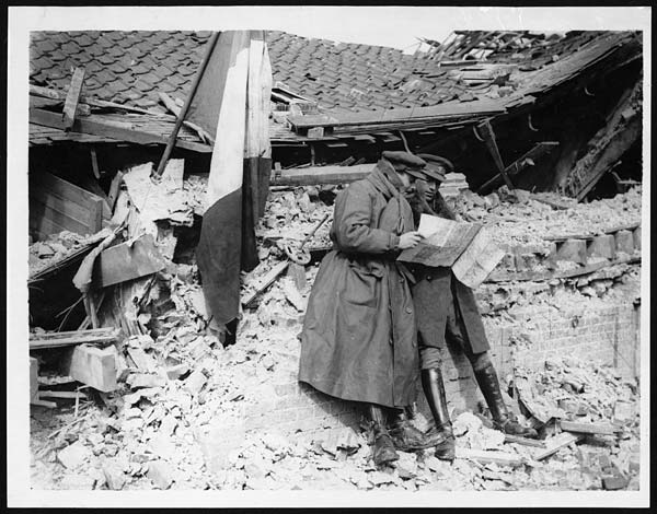
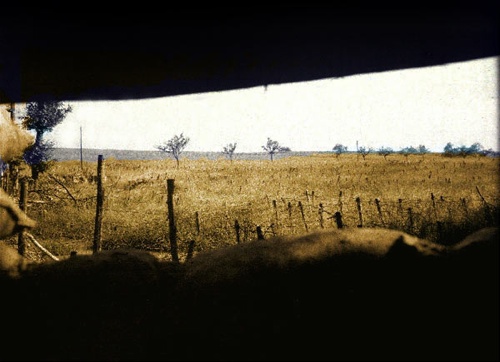
The notes contain various references to No Man’s Land in the First World War, though I’m increasingly interested in what lies on either side.  One of the reasons so many commentators seem to think that ‘war among the people’ is a recent development is that the imagery of the Western Front draws the eye again and again to No Man’s Land, but behind the front lines on either side were farms, fields, villages and small towns where people continued to live and work amongst the shelling, the gas attacks, and the billeted troops.

As usual, I’d welcome any comments/criticisms/suggestions on the (I hope near final) draft of the essay: an extended version will appear in War material.