Digital airstrikes and physical casualties

Afghanistan

The US military defines Close Air Support (CAS) as ‘air action by fixed-wing and rotary-wing aircraft against hostile targets that are in close proximity to friendly forces, and [it] requires detailed integration of each air mission with the fire and movement of those forces.’  It’s a difficult and dangerous business, and not only for the intended targets.

The technologies of CAS have been transformed but, according to the the Defense Advanced Research Projects Agency, its fundamentals haven’t changed since the First World War.

‘Pilots and dismounted ground agents must ensure they hit only the intended target using just voice directions and, if they’re lucky, a common paper map. It can often take up to an hour to confer, get in position and strike—time in which targets can attack first or move out of reach.’

To achieve what is in effect the time-space compression of the kill-chain, DARPA is developing its Persistent Close Air Support program to provide an all-digital system.  The system ‘lets a Joint Tactical Air Controller call up CAS from a variety of sources, such as aircraft or missile platforms, to engage multiple, moving and simultaneous targets,’ explains David Szondy (from whom I’ve borrowed the short-hand ‘digital airstrikes’). ‘By eliminating all the radio chatter and map fumbling, the exercise is much faster and more accurate with reduced risk of friendly fire incidents.’  The program manifesto, for want of a better word, includes these aims and specifications:

The program seeks to leverage advances in computing and communications technologies to fundamentally increase CAS effectiveness, as well as improve the speed and survivability of ground forces engaged with enemy forces.

The program envisions numerous benefits, including:

  • Reducing the time from calling in a strike to the weapon hitting the target by a factor of 10, from up to 60 minutes down to just 6 minutes 
  • Direct coordination of airstrikes by a ground agent from manned or unmanned air vehicles
  • Improved speed and survivability of ground forces engaged with enemy forces
  • Use of smaller, more precise munitions against smaller and moving targets in degraded visual environments
  • Graceful degradation of services—if one piece of the system fails, warfighters would still retain CAS capability

PCAS_ProgramPage_Image

PCAS has two components:

The first is PCAS-Air, which … involves the use of internal guidance systems, weapons and engagement management systems, and communications using either the Ethernet or aircraft networks for high-speed data transmission and reception. PCAS-Air processes the data received, and provides aircrews via aircraft displays or tablets with the best travel routes to the target, which weapons to use, and how best to use them.

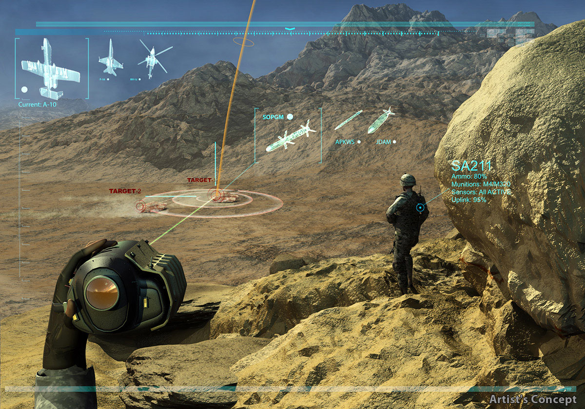
The other half is PCAS-Ground, intended for improved mobility, situational awareness and communications for fire coordination. Soldiers on the ground can use an HUD eyepiece wired to a tablet that displays tactical imagery, maps, digital terrain elevation data, and other information [the image above is an artist’s impression of the Heads-Up Display]. This means they can receive tactical data from PCAS without having to keep looking at a computer screen.

PCAS-Ground has been deployed in Afghanistan since December 2012.  The original plan, as the emphasis on ‘persistent’ implies, was to integrate the system with drones, but after the cancellation of the US Air Force’s MQ-X (‘Avenger’) program Raytheon announced that PCAS would be developed using a conventional A-10 Thunderbolt.

There is of course a long history to the digitisation and automation of the battlespace, and that reference to the First World War was not an anachronism.  There were such intimate links between mapping, aerial photography and artillery ranging on the Western Front – whose cascade of updated imagery and intelligence underwrote the seeming stasis of trench warfare – that Peter Chasseaud described the result as ‘a sophisticated three-dimensional fire-control data base’ through which ‘in effect, the battlefield had been digitised.’  It was also, in a sense, automated; I discuss this in detail in ‘Gabriel’s Map’, but it’s captured perfectly in Tom McCarthy‘s novel C.

More obvious way stations to the present include the Vietnam-era Electronic Battlefield, whose sensor-shooter system I described in ‘Lines of descent’ (DOWNLOADS tab) as a vital precursor to today’s remote operations:

Another was the development of the PowerScene digital terrain simulation that was used to identify target imagery transmitted by proto-Predators over Bosnia-Hercegovina and to rehearse NATO bombing missions.

PowerScene at Wright-Dayton AFBRemarkably, it was also used at Wright-Patterson Air Force Base during the negotiations that led to the Dayton peace accords. As one US officer explained:  ‘It’s an instrument of war but we’ll use it for peace because you are willing to come to the table’.  The system was used to explore proposals for potential boundaries, but the sub-text was clear: if agreement could not be reached, NATO had a detailed military knowledge of terrain and targets.  (For more, see James Hasik‘s Arms and innovation: entrepreneurship and alliances in the twenty-first century defense industry (2008) Ch. 6: ‘Mountains Miles Apart’; Richard Johnson‘s ‘Virtual Diplomacy’ report here; and a precocious paper by Mark Corson and Julian Minghi here, from which I’ve taken the image on the left).

powerscene2PowerScene was later used by USAF pilots rehearsing simulated bombing missions against Baghdad in the 1990s (see right) – the system fixed target co-ordinates and red ‘bubbles’ displayed threats calibrated on the range of surface-to-air missile systems – and when Anteon Corporation and Lockheed Martin introduced TopScene air strikes over Afghanistan in 2001 were also rehearsed over digital terrain.

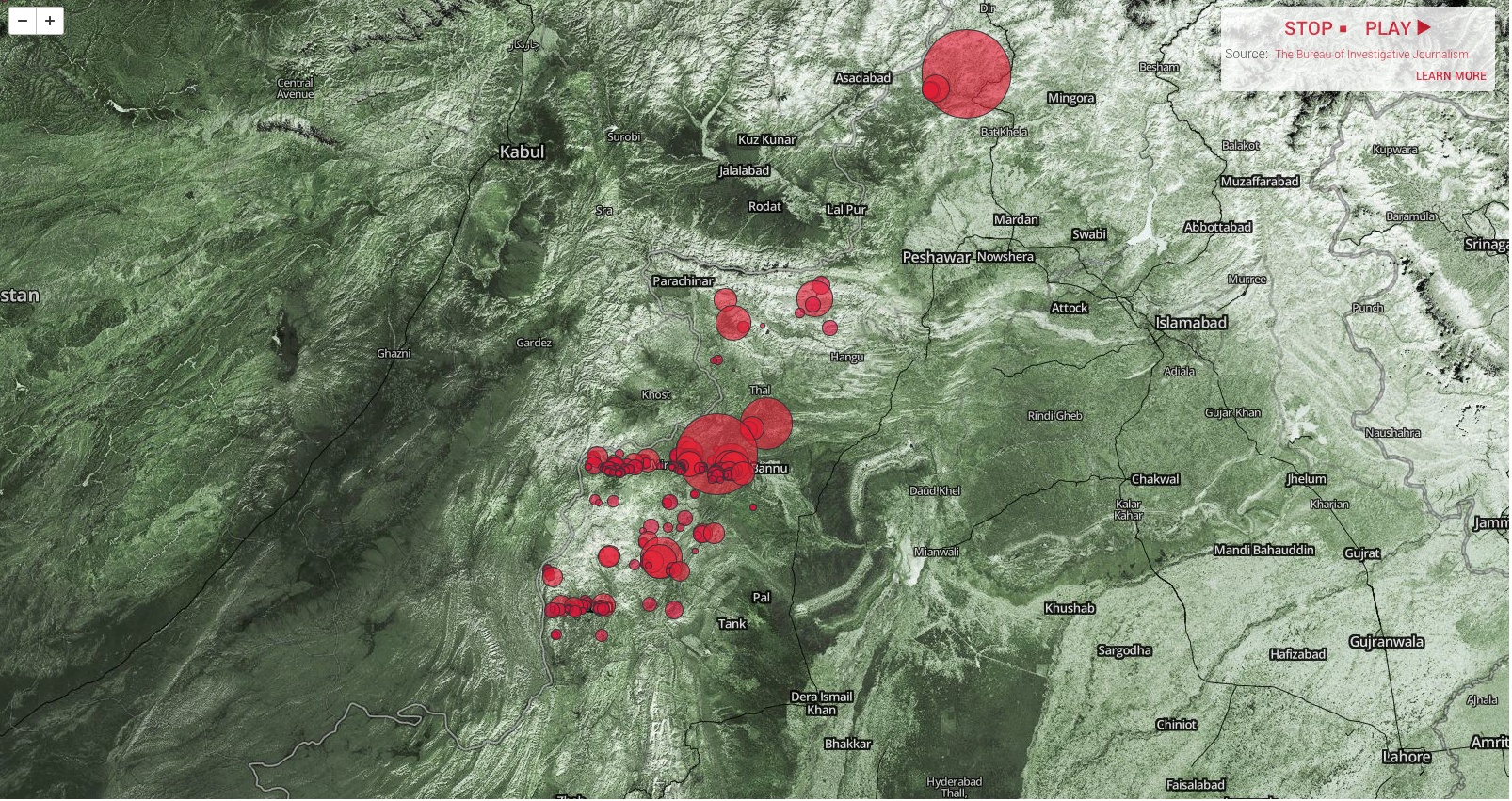
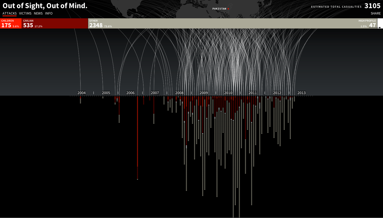
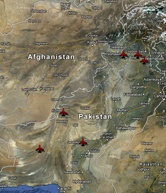
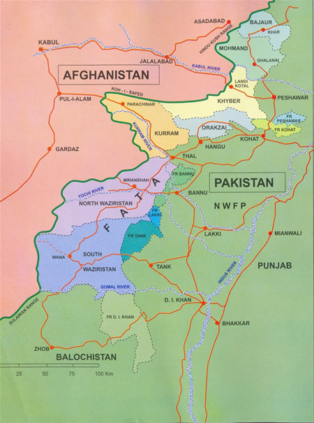
But there is another side to all this, because digital platforms can also be used to enable others to display and interrogate the geography of air strikes.  I’ve discussed this before in relation to the CIA-directed program of targeted killing in Pakistan here and here, but impressive progress has also been made in plotting air strikes across the border in Afghanistan.

The most remarkable use of USAF/ISAF data that I know is Jason Lyall‘s work in progress on what he calls ‘Dynamic coercion in civil wars’ – ‘Are airstrikes an effective tool of coercion against insurgent organizations?’ – which focuses on air strikes in Afghanistan between 2006 and 2011. This is part of a book project, Death from above: the effects of airpower in small wars; the most recent version of the relevant analysis is here.  The map below is Jason’s summary of air strikes in Afghanistan 2006-11, but as I’ll explain in a moment, it gives little idea of the critical digital power that lies behind it.

JASON LYALL Air strikes in Afghanistan 2006-2011

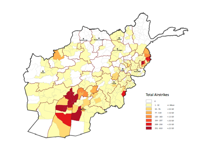
First, the original USAF/ISAF data was in digital form, but transforming it into a coherent and consistent geo-coded database has involved a truly extraordinary enterprise:

We draw on multiple sources to construct a dataset of nearly 23,000 airstrikes and shows of force in Afghanistan during 2006-11. The bulk of the dataset stems from newly-declassified data from the Air Forces Central’s (AFCENT) Combined Air Operations Center (CAOC) in Southwest Asia, which recorded the location, date, platform, and type/number of bombs dropped for January 2008 to December 2011 in Afghanistan. These data required extensive cleaning to ensure that a consistent standard for each type of air operation was maintained and duplicates dropped. These data were supplemented by declassified data from the International Security Assistance Force’s (ISAF) Combined Information Data Exchange Network (CIDNE) for the January 2006 to December 2011 time period. Finally, additional records from press releases by the Air Force’s Public Affairs Office (the “Daily Airpower Summary,” or DAPS) were also incorporated. … Each air operations’ intended target was confirmed using at least two independent coders drawing on publicly available satellite imagery. Merging of these records was extremely labor intensive, not least because of the near total absence of overlap between CAOC, CIDNE, and DAPS records. Only 448 events were found in all three datasets, underscoring the problems inherent in single-sourcing data, even official data, in conflict settings (my emphasis).

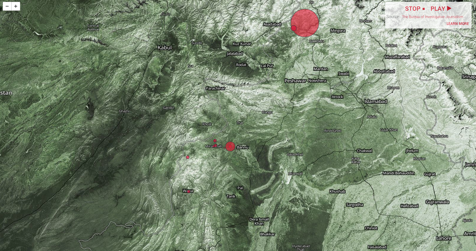
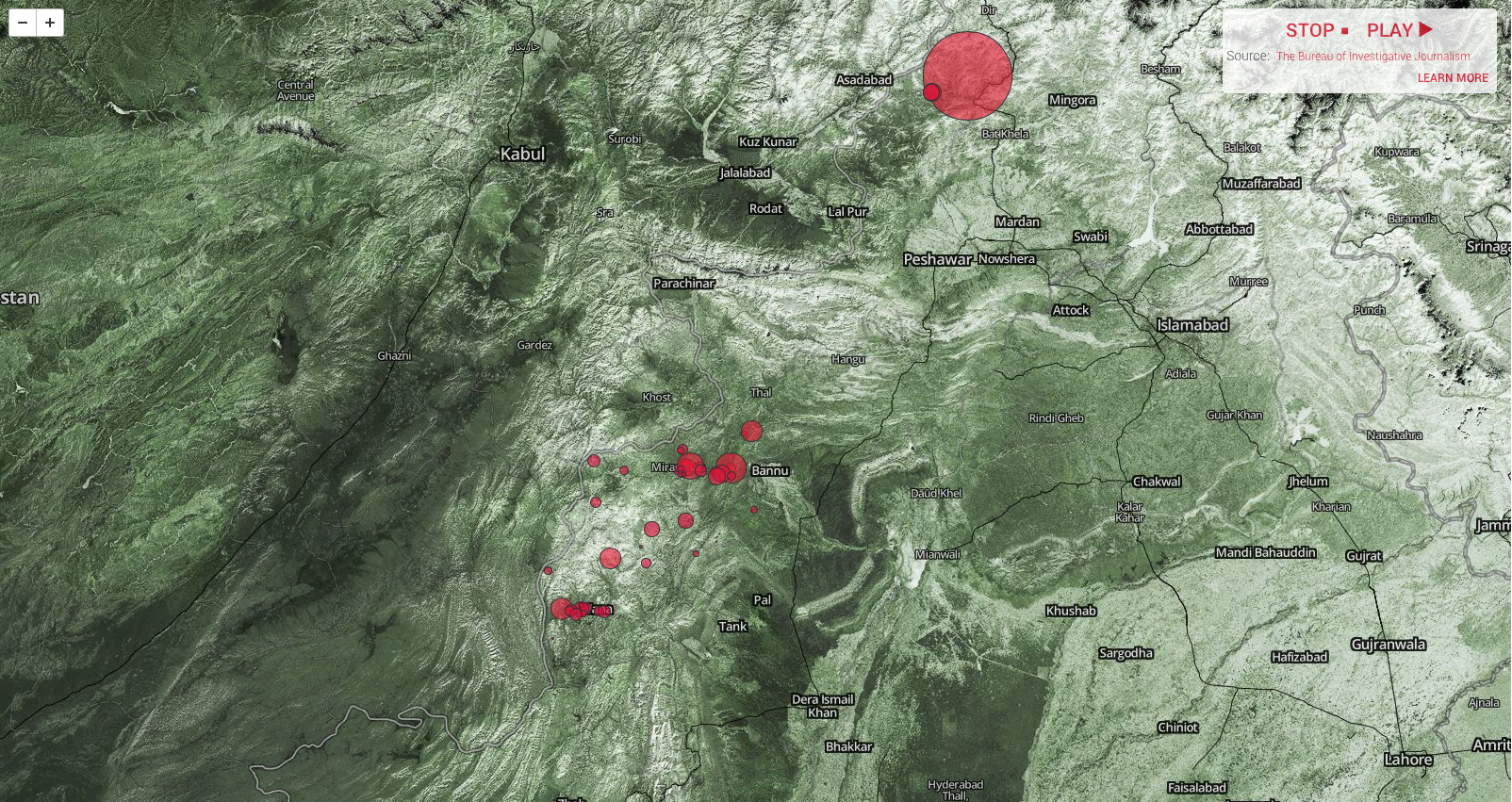
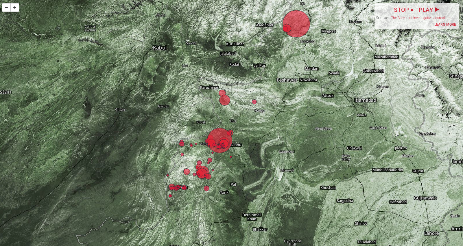
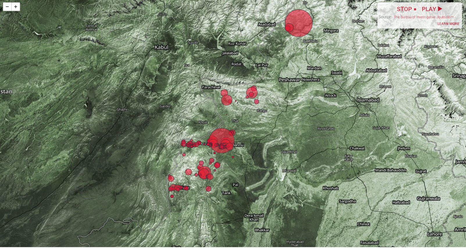
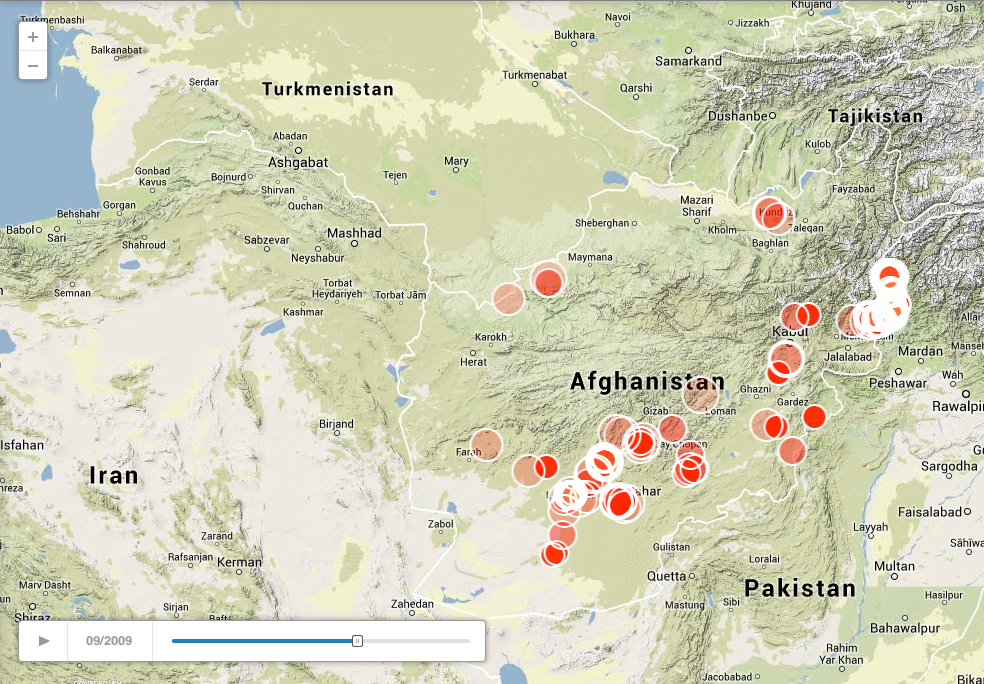
Second, to get the full visual effect of Jason’s analysis you absolutely need to see the animation that he’s made available on his website here; the image below is just a screenshot for September 2009 (I’ll explain why I chose that month in my next post).

JASON LYALL Air strikes in Afghanistan 09:2009

But what about casualty figures?  Josh includes a summary map of 216 air strikes involving acknowledged civilian casualties, taken from the same military databases (with all their limitations), and in January 2011 the US military released its data on ‘CIVCAS’ for the previous two years to the journal Science.  They included casualties from all parties to the conflict:

The numbers show that 2,537 Afghans civilians were killed and 5,594 were wounded in the past two years. Most of the deaths – 80 percent – are attributed to insurgents, with 12 percent caused by coalition forces, a 26 percent drop.

Here is Science‘s visualization of the CIVCAS data, designed to capture the time-space rhythms of violence from multiple causes:

F2.medium

You can access the interactive version here.

But other sources (notably the Afghan Rights Monitor and the UN Mission in Afghanistan, UNAMA, which produces six-monthly Reports on the protection of civilians in armed conflict) using different methodologies came up with much higher figures; here is a graph from the most recent UNAMA report showing casualties from air strikes 2009-13:

UNAMA Civilian casualties from air attacks 2009-13

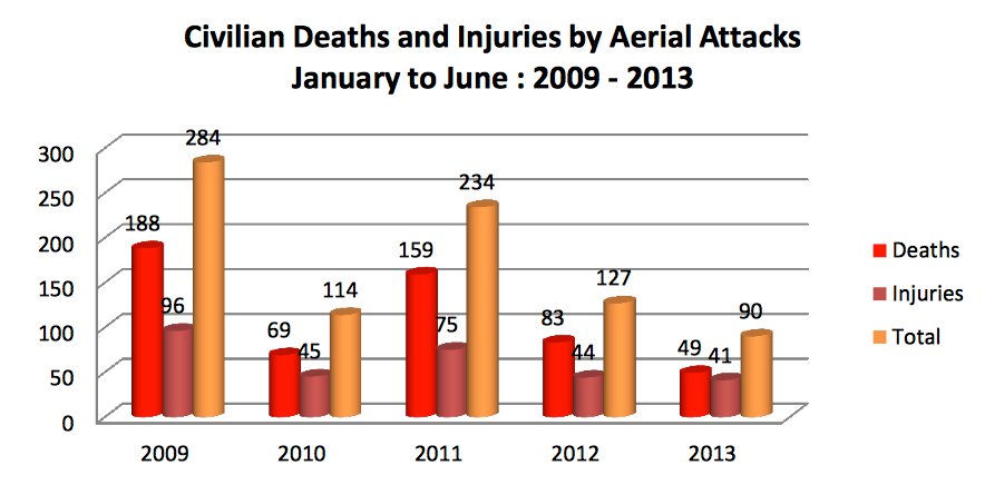
UNAMA added this comment:

UNAMA welcomes the reduction in civilian casualties from aerial operations but reiterates its concern regarding several operations that caused disproportionate loss of civilian life and injury. UNAMA also raises concerns with the lack of transparency and accountability about several aerial operations carried out by international military forces that resulted in civilian casualties.

You can find the full analysis by John Bohannon, which includes a discussion of both databases, at Science (open access) here.

To be sure, counting casualties is always a contentious (and often dangerous) affair.  Getting information from the government of Afghanistan isn’t any more straightforward, as Nick Turse has shown: as he adds, ‘neither is it cheap’.  But he persevered, and the wonderful Pitch Interactive (a data visualization studio that also produced the haunting representation of deaths from drone strikes in Pakistan) collaborated with The Nation to produce a stunning interactive of ‘civilian deaths that have occurred in Afghanistan as a result of war-related actions by the United States, its allies and Afghan government forces.’  Here’s a screenshot:

Civilian fatalities in Afghanistan 2001-2012

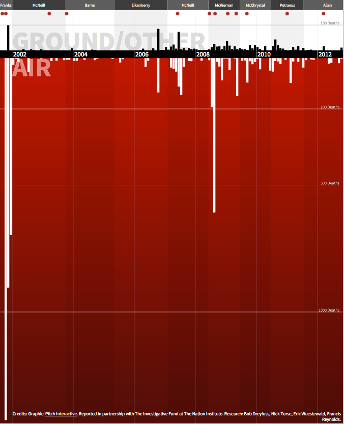
You will see running along the top the military commanders during each period; the red dots mark major events.  It’s common knowledge – or should be – that the US-led invasion of Afghanistan in 2001 was spearheaded by an intensive high-level bombing campaign (I described this in The Colonial Present), shown along that desperately deep left margin.  But I suspect fewer people have grasped the reliance that ISAF has continued to place on air power.  What stands out from the image above, clearly, is the disproportionate (sic) number of deaths attributed to air strikes (5, 622) compared with ground operations (794) throughout the period: the UNAMA data above suggest that this only started to change in 2013. You can read more about this in the essay by Bob Dreyfuss and Nick Turse that accompanied the interactive, ‘America’s Afghan victims’, here, and – as always – the tireless work of Marc Herold is indispensable.

And to forestall a stream of comments, my title is not intended to suggest that digital technologies or the airstrikes they facilitate are somehow ‘immaterial’; nothing could be further from the truth.  Or the killing fields.

Dirty dancing and spaces of exception in Pakistan

Following up my post on the air campaigns waged by the United States and by Pakistan inside the Federally Administered Tribal Territories and the North-West Frontier Province (now Khyber Pakhtunkhwa), here are some screenshots from Chris Herwig‘s remarkable cartographic animation of casualties from US drone strikes from 2004 through to the present (data from the Bureau of Investigative Journalism):

Casualties from US drone strikes to end December 2007

Casualties from US drone strikes to end December 2007

Casualties from US drone strikes to end December 2008

Casualties from US drone strikes to end December 2008

Casualties from US drone strikes to end December 2009

Casualties from US drone strikes to end December 2009

Casualties from US drone strikes to end December 2010

Casualties from US drone strikes to end December 2010

Casualties from US drone strikes to end December 2011

Casualties from US drone strikes to end December 2011

Casualties from US drone strikes to end December 2012

Casualties from US drone strikes to end December 2012

You can see the rapid escalation of strikes in 2009-2010 and their contraction in 2011-2012.  There is also a tendency for later strikes to cause fewer casualties; the Bureau suggests that this may have been the result of a deliberate decision to limit civilian casualties (the CIA was already reported to be using new, smaller missiles with a restricted blast field and minimal shrapnel by the spring of 2010, so the later change is likely to be down to a mix of better intelligence and greater circumspection) and, more recently, of a switch away from ‘signature strikes’ – the two are of course related – and John Brennan, who was one of the main boosters of the programme’s expansion, now claims that drone strikes are a weapon ‘of last resort’.  Maybe; most sources agree that even as the numbers of deaths dwindled, so too did their tactical significance.  By February 2011 it was clear that fewer and fewer were so-called ‘high-value targets’ and more and more were simply foot-soldiers.

Here are the Bureau’s raw figures:

Drone strikes in Pakistan (BoJ)

You can find an interactive animation of the Bureau’s tabulations from Pitch Interactive here (thanks to Steve Legg for the tip); the screenshot below doesn’t do justice to the political-aesthetic effect of seeing this in full motion (or of clicking on each strike for the details):

Drone strikes in Pakistan PITCH INTERACTIVE

The maps also show that the strikes have been concentrated on North Waziristan, increasingly so since 2010, the locus of the Haqqani Network (which is a longstanding ally of Pakistan’s Inter Services Intelligence), with a secondary concentration on South Waziristan (a key locus of Tehrik-i-Taliban).  Here’s a tabulation from the Long War Journal, and although the strike numbers are marginally different from the Bureau’s the geographical concentration is clear:

US air strikes in FATA by district

What the maps can’t convey is the intricate, inconstant gavotte between Pakistan’s various military campaigns and US air strikes in the borderlands since 2004.  In the wake of 9/11 and the US-led invasion of Afghanistan, and in response to increasing pressure from Washington, the Pakistan Army launched a number of offensives against militants in the Federally Administered Tribal Areas (FATA).  In April 2004, after fierce fighting in the mountains of South Waziristan, Islamabad concluded a peace accord with Nek Muhammad, a key militant leader in the agency.  But he was killed just two months later, the first casualty of a US drone strike in Pakistan, and the agreement immediately collapsed.   In 2005 similar, fragile agreements were negotiated with Baitullah Mehsud, Nek’s successor, and other militant leaders, but these were soon broken.  Accords were also signed in North Waziristan in 2006 and 2007 but these too were short-lived.  In 2008 a peace accord was signed with the Tehrik-i-Taliban but heavy fighting continued, with major ground and air operations in the agencies to the north of the Khyber Pass.  In 2009 Pakistan’s military campaign became even more aggressive. Much of its effort was focused on the northern districts, especially around the Swat Valley, but attention then switched back to South Waziristan.  During the summer the Pakistan Air Force carried out regular air strikes in the region; in August 2009 Baitullah Mehsud was killed in a US drone strike.  In October 30,000 ground troops entered the region, and US drone strikes in South Waziristan immediately juddered to a (temporary) halt.  These operations drove large numbers of militants into Orakzai, which in recent years has been a major target of air strikes by the Pakistan Air Force.

The previous paragraph is little more than a caricature of a highly complex and evolving battlespace, but the gavotte I’ve described has been artfully – if intermittently – choreographed by the US and by Pakistan in fraught concert: so much so that Joshua Foust writes of the ‘Islamabad drone dance’.

This may surprise some readers; earlier this month Ben Emmerson QC, the UN Special Rapporteur on Counterterrorism and Human Rights, concluded a three-day visit to Pakistan by reaffirming what he described as ‘the position of the government of Pakistan’ that drone strikes in the FATA ‘are a violation of Pakistan’s sovereignty and territorial integrity.’  Emmerson met with officials from the Ministry of Foreign Affairs, the Ministry of Defence and the Secretariat of the FATA – but not, significantly, with anyone from the military or the ISI – who told him that ‘reports of continuing tacit consent by Pakistan to the use of drones on its territory by any other State are false’ and that ‘a thorough search of Government records had revealed no indication of such consent having been given.’ Certainly, the government has repeatedly protested the strikes in public, and the National Assembly passed resolutions in May 2011 and April 2012 condemning them.  But Foust insists that Emmerson has been an unwitting participant in the dance.

We know, from the Wikileaks cache of diplomatic cables from the US Embassy in Islamabad, that in August 2008 Prime Minister Yousaf Raza Gillani told the Ambassador that he approved of the drone strikes as part of ongoing offensives in the FATA – ‘I don’t care if they do it as long as they get the right people’ – and that ‘We’ll protest it in the National Assembly and then ignore it.’  But this was more than ‘tacit consent’.  Foust reminds us that, until comparatively recently, US drones were being launched or supported from at least six different air bases inside Pakistan, shown below, including Islamabad, Jacobabad, Peshawar, Quetta and Tarbela Ghazi; the US was ordered to leave Shamsi and had its lease terminated in December 2011.

US bases inside Pakistan

Admiral Mullen greets General Kayani, August 2008But there’s more. Pakistan had agreed that the focus of the US strikes would be North and South Waziristan.  Earlier that same year, March 2008, the Chairman of the Joint Chiefs of Staff Admiral Mullen asked General Kayani, Pakistan’s Chief of Army Staff,  for help in approving ‘a third Restricted Operating Zone for US aircraft over the FATA’, and writing in the Washington Post in November 2010 Greg Miller confirmed that these ‘flight boxes’ were confined to North and South Waziristan (although the US had unsuccessfully pressed for permission to extend the flights over Quetta, outside the FATA).  The geometry of those boxes is not known, though it would not be difficult to superimpose two likely rectangles over the previous map sequence. Operational details are, not surprisingly, far from clear.  According to a report in the Wall Street Journal on 26 September 2012, the CIA sends a fax to the ISI every month detailing strike zones and intended targets – replies apparently stopped early last year, but the US interprets the silence as ‘tacit consent’ since Pakistan immediately de-conflicts the air space to allow the Predators to carry out their surveillance – and a report in the New York Times earlier this month claimed that the US still provides the Pakistan military with 30 minutes notice of an imminent strike in South Waziristan (but no advance notice for strikes in North Waziristan because the Haqqani Network enjoys such close ties with the ISI that the CIA fears their targets would be warned of the attack).

The focus on the FATA follows not only from the militant groups that are based there; it also derives from the exceptional legal status of the borderlands.  Under British colonial rule, this was a buffer zone whose inhabitants were allowed a measure of nominal autonomy; colonial power was exercised indirectly through the authority vested in tribal leaders (who received subsidies from the British), and the special Frontier Crimes Regulations – in practice corrupt and draconian – were codified by Lord Curzon in 1901.  After partition and independence in 1947 Pakistan retained the 1901 Regulations, so that the President – who has direct executive control of the FATA – appoints a Political Agent for each agency who has absolute authority to adjudicate criminal and civil affairs; ordinary Acts of Parliament do not apply to the FATA unless the President expressly declares that they do. Limited reforms were introduced in August 2011, including the right to political mobilisation, but some commentators raised doubts about their implementation.  Preventive detention and collective punishment remain in force and the writ of the courts is still severely restricted.

FATA and NWFP map

AMNESTY The Hands of Cruelty Abuses by Armed Forces and Taliban in Pakistan s Tribal AreasThese special measures were reinforced by the simultaneous passage of the Actions (in Aid of Civil Power) Regulations in 2011, a quid pro quo demanded by the military, which allowed the Pakistan Armed Forces to carry out ‘law enforcement duties [and] to conduct law enforcement operations’, granted them sweeping powers of pre-emptive arrest and detention without charge, and forbade the high court from intervening.  According to one local politician, these new Regulations are ‘even more dangerous’ than the Frontier Crimes Regulations: ‘It is a system of martial law over the Tribal Areas.’  A new report from Amnesty International (from which I’ve taken these accounts) borrows its title, The Hands of Cruelty, from a despairing claim made by a lawyer from Peshawar: ‘The hands of cruelty extend to the Tribal Areas, but the hands of justice cannot reach that far.’

(Given the – I think abusive – attack on Amnesty’s report by Abdullah Mansoor at Global Research as ‘malicious’ and ‘misinformation’ that virtually ignores the violence perpetrated by the Taliban and other militant groups, I should also draw readers’ (and his) attention to Amnesty’s previous report, As if Hell fell on me, which provides a detailed indictment of exactly that).

In short, the FATA constitute a space of exception in precisely the sense given to that term by Giorgio Agamben: the normal rights and protections under the law are withdrawn from a section of the population by the law.  To see what this has to do with the geography of US drone strikes we can turn to an attack on 19 November 2008 on a residential compound in Indi Khel, 22 miles outside Bannu and about two hours by road from Peshawar.  Five alleged militants were killed and four civilians injured: not a large toll compared to other strikes, and yet the public reaction across Pakistan was extraordinary.

Drone strike at Indi Khel, Bannu, 19 November 2008

A diplomatic cable from US Ambassador Anne Patterson on 24 November explained the widening gap between what she called ‘private GOP [Government of Pakistan] acquiescence and public condemnation for U.S. action’:

‘According to local press, the alleged U.S. strike in Bannu on November 19 marked the first such attack in the settled areas of the Northwest Frontier Province, outside of the tribal areas. The strike drew a new round of condemnation by Prime Minister Gilani, coalition political parties, opposition leaders, and the media.

‘According to Pakistani press, the strike killed four people, including a senior Al-Qaida member, and injured five others. The first strike within “Pakistan proper” is seen as a watershed event, and the media is suggesting this could herald the spread of attacks to Peshawar or Islamabad. Even politicians who have no love lost for a dead terrorist are concerned by strikes within what is considered mainland Pakistan.’

The language is truly extraordinary, with its distinction between the FATA and ‘Pakistan proper’, even ‘mainland Pakistan’. In short: (imaginative) geography matters.  Not for nothing are the FATA known in Urdu as ilaqa ghair, which means ‘alien’ or ‘foreign’ lands.

The plight of the people in the FATA is exacerbated by the forceful imposition of a second, transnational legal regime: the right asserted by the United States to carry its fight against al Qaeda and its war against the Taliban across the border from the ‘hot’ zone in Afghanistan into militant sanctuaries in Pakistan.  This is part of a larger argument about the advanced deconstruction of the traditional, bounded battlefield – here Frédéric Megret‘s work is indispensable – and the production of a global battlespace, processes that have been accelerated by the remote operations permitted by drones.  But it remains both an assertion and an argument.  Although international law is not a deus ex machina, a neutral court of appeal above the fray, it nonetheless has a developed body of precepts that are supposed to regulate armed conflicts between states, and there are also protocols and tribunals that govern armed conflicts between governments and non-state actors within the territorial boundaries of a state (the former Yugoslavia or Ruanda, for example).  But conflicts between states and transnational non-state actors pose new and difficult questions, and perhaps even map a ‘legal void’.  Significantly, as Eyal Benvenisti points out in the Duke Journal of International and Comparative Law,

Concurrently with the successful efforts to impose restraints on intra-state asymmetric warfare, we have been witnessing efforts by the same powerful countries that pressed for intra-state conflict regulation to deregulate inter-state asymmetric warfare or what may be called “transnational” warfare.

I will leave a review of these debates, at once legal and political, for another day; among the most relevant recent contributions are Kenneth Anderson, ‘Targeted killing and drone warfare: how we came to debate whether there is a legal geography of war’ (2011), available here; Laurie Blank, ‘Defining the battlefield in contemporary conflict and counterterrorism: understanding the parameters of the zone of combat’, Georgia Journal of International and Comparative Law 39  (1) (2010-11), available here; Jennifer Daskal, ‘The geography of the battlefield: a framework for detention and targeting outside the “hot” conflict zone’ (2012), available here;  Noam Lubell and Nathan Derejko, ‘A global battlefield? Drones and the geographical scope of armed conflict’, Journal of International Criminal Justice 11 (1) (2013) 65-88 (abstract here).  In this twilight zone, where Washington at once admits its actions through a never-ending string of off-the-record briefings and yet denies any responsibility for their collateral outcomes, there are no inquiries into ‘mistakes’, no culpability for wrong-doing, and no compensation or restitution for the innocent victims.

Whatever you make of the rights and wrongs of all this, what matters for my present purposes is that these two legal regimes, one national and the other transnational, work in concert to expose the people of the Federally Administered Tribal Areas to military and paramilitary violence and, ultimately, death.

It’s more than a matter of law, of course (and in any case we shouldn’t confuse legality with legitimacy).  Within these exceptional spaces there has been active, tactical collaboration between the US and Pakistan.  Another diplomatic cable reported a meeting on 22 January 2008 with General Kayani, who asked US Central Command to provide ‘continuous Predator coverage of the conflict area’ in South Waziristan, but was offered only Joint Terminal Attack Controllers to direct PAF air strikes by F-16s – an offer which was refused because of a reluctance to allow US ground forces to operate inside Pakistan.  But in September and October 2009 small teams of US Special Forces were deployed to provide intelligence, surveillance and reconnaissance (ISR) support to the Pakistan Army, which included a ‘live downlink of unmanned aerial vehicle (UAV) full motion video.’ (What is interesting about all these exchanges is the degree of collaboration they reveal not only between the US and Pakistan but also between the CIA and the US military, especially Joint Special Operations Command; this is not surprising, given the hybridisation of military and paramilitary violence and the close involvement of the military in supplying, servicing and even flying the drones used in CIA-directed strikes).

There have been several reports of continuing collaboration between American and Pakistani intelligence operatives working on the ground in Pakistan, and one source – who purported to run a network of agents and ‘spotters’ in North and South Waziristan – told Reuters in January 2012 that ‘Our working relationship is a bit different from our political relationship.  It’s more productive.’  He claimed that the US and Pakistan agreed priority target lists between them, and that it took little more than two or three hours between the location of a targeted individual and the firing of missiles.  These claims are impossible to verify, but the emphasis on a working relationship rings true.

FATA flagPerhaps the most chilling of the Wikileaks cables is this (redacted) message sent from Islamabad in February 2009, reporting a discussion with a senior member of the FATA Secretariat, who enthusiastically recommended the practice of ‘double tap‘ – follow-up strikes targeting rescuers – and endorses the rationale for signature strikes against unknown, un-named targets:

9.  (S)  XXXXXXXXXXXX remains a strong advocate of U.S. strikes. In fact, he suggested to PO that the U.S. consider follow-on attacks immediately after an initial strike.  He explained that after a strike, the terrorists seal off the area to collect the bodies; in the first 10-24 hours after an attack, the only people in the area are terrorists, so “you should hit them again-there are no innocents there at that time.”  His sources report that the reported September 29 strike in South Waziristan had been particularly successful; “you will see that you hit more than has been reported in the press both in terms of quantity and quality.”  XXXXXXXXXXXX also drew a diagram essentially laying out the rationale for signature strikes…

Here you can see two perspectives on administrative killing, one from Pakistan and the other from the United States, converging onto a single target.

The cables from which I’ve quoted are all four or five years old, but this reflects the shutters coming down after the subsequent assault on Wikileaks and the arrest of  Bradley Manning – the reports from seasoned investigative journalists are much more recent.  I suppose you might conclude that none of them contradicts that artful word that does so much silent work in the official statement repeated by Emmerson, in which Pakistan denies reports of continuing tacit consent.  But given what I’ve shown about the deadly dance over those five years, do you really think the music has stopped?