Predators over the FATA

The Bureau of Investigative Journalism in London has published a confidential reportDetails of Attacks by NATO Forces/Predators in FATA, whose tabulations cover more than 70 drone strikes in Pakistan’s Federally Administered Tribal Areas between January 2006 and October 2009.

The tabulations are significant because they are not based on press reports – the standard and highly imperfect source – but on reports prepared for the FATA Secretariat and transmitted to Islamabad by government agents in the field (who rely on their own observations, and reports from the tribal police and other informants).  According to one well-placed observer, ‘There was no benefit in officials “cooking the books” here, since this document was clearly never intended to be seen outside the civilian administration.’

Predator/NATO strikes in FATA

It’s an incomplete list – the Bureau has a more comprehensive tabulation – but of the 746 deaths from these air strikes 147 (20 per cent) are identified as civilians (including 94 children).

Still, the Bureau notes some puzzling (even troubling) omissions.  In particular, reports of civilian deaths virtually disappear from the record after Obama took office: ‘In part this is because officials occasionally note that “details of casualties are yet to be ascertained.” But many credible reports of civilian deaths are simply missing. The Bureau’s own research shows that civilian deaths have been credibly reported in at least 17 of the 53 CIA drone strikes in Obama’s first year in office. Yet FATA officials report civilian deaths in only three incidents in 2009.’

There have been rumours of more comprehensive tabulations, but the Bureau acknowledges that much also depends on information provided by the Pakistani military.  And it would be interesting to see a comparable list of casualties resulting from Pakistan’s own air strikes in the FATA.

Watching the drones

An interesting interview over at the Huffington Post with Wesley Grubbs, one of the visual designers at Berkeley-based Pitch Interactive responsible for the infographic of drone strikes in Pakistan that was released on Monday and has since gone viral.  I drew attention to it in my discussion of the geography of those strikes, but that dimension doesn’t appear in this otherwise compelling infographic (screenshot below).  The project is called Out of Sight, Out of Mind which certainly speaks to the politics of drone warfare but it’s also out of site, and the geography of these strikes, as I tried to show, is not incidental to those politics.

Drone strikes in Pakistan PITCH INTERACTIVE

I think that the political-aesthetic effect of this visualization – which is considerable, otherwise why so much attention? The numbers aren’t new to anyone who’s followed the Bureau of Investigative Journalism‘s painstaking work –  is bound up less with the raw numbers and more with those silver-grey arcs of light falling to the ground line: it’s a much more sobering (and I dare say thrilling) effect than a lifeless (sic) table.  As I watch them descend, I’m drawn back to images of much earlier bombings, and the lights exploding against a velvet sky.  And a visualization is doubly appropriate to a weapon that depends so much on visual apprehension – full-motion video feeds – and yet whose operation in the borderlands is shrouded in such semi-secrecy.  Grubbs told the Bureau that their intention was ‘to cause people to pause for a moment and say “Wow I’ve never seen this in that light before”.’

The site is live  – it will be updated in real time – and the same design group is intent on developing similar visualizations for drone strikes in Yemen and Somalia.

The Bureau’s work, the primary basis for the interactive, is so careful and considered that this attempt to downplay and even dismiss Pitch Interactive’s project is either simply ignorant or just plain silly.  The author objects that the numbers ‘aren’t exact’ and wants to see the full spreadsheet – but the Bureau has made its detailed databases available and discussed their limitations in depth and detail: what better (‘exact’) sources does she have in mind?  Perhaps she should try here.

I’m not sure that this is much better.  Its author concludes: ‘Put simply, the visualization is implying that of 3,105 drone-strike casualties, only 47 are known to be legitimate kills. This is nonsense.’ Actually, what is nonsense is to misread and mis-represent the infographic in this way; what the website clearly says is that less than 2 per cent of the victims (a total of 47 people) have been ‘high profile targets’ (the original object of Sylvan Magnolia, the code-name for the covert war).

Not incidentally, less than twenty per cent of those killed in the strikes have been named, and the Bureau has just released a short video to crowd-source funding so that their raw numbers are finally turned into names:

You can donate here.

Air strikes in Pakistan’s borderlands

I’m speaking about Drone strikes and the matrix of violence in Pakistan at a conference in Vancouver at the week-end – a presentation which will form part of The everywhere war – and to set some of the parameters I’ve been revisiting the changing geography of air strikes in the Federally Administered Tribal Areas.  It’s a formidably difficult question given the extraordinary dangers facing journalists, Pakistani or foreign, seeking to report from the FATA: for an incisive discussion of the media landscape inside the FATA see Sadaf Baig‘s Reporting from the frontlines.

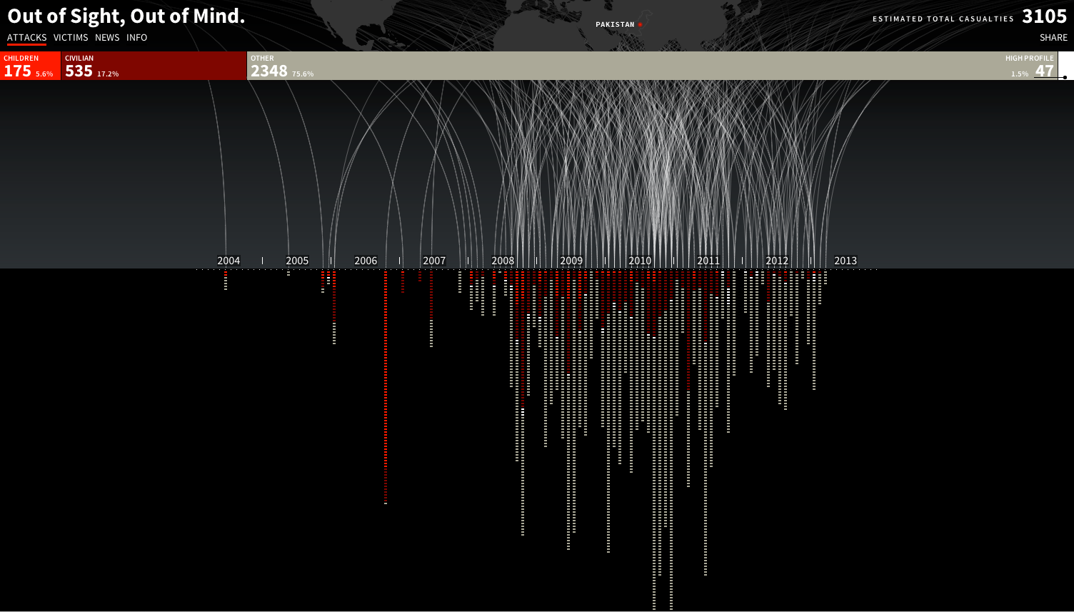
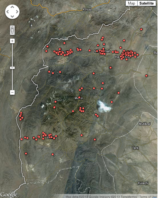
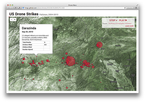
In my view, the most thorough if necessarily imperfect tabulations of US-directed strikes are those provided by the Bureau of Investigative JournalismThere have been several attempts to map this database, including the Bureau’s own use of Google maps (see below and here; but be careful: zooming in is a product of the digital platform and will give a misleading sense of the resolution level of the data).

BOJ US drone strikes in FATA

One of the most thoughtful (and dynamic) representations comes from Chris Herwig.  He described the technical basis of his mapping over at MapBox here, and you can visit his microsite here.  Go here to see the animation running (with annotations).

8448237526_92002912de

Chris’s project has also been featured on PBS here, where he also responds to several criticisms of the data and his visualizations.

Over at Slate, Chris Kirk has produced an interactive that tries to show the maximum number of estimated casualties from each strike, but the data are drawn from the New America Foundation database which has been criticised for underestimating casualties; one (to October 2012) version is here, and another (to February 2013), using a different cartographic design, is here.  More generally, Forensic Architecture‘s Unmanned Aerial Violence team is working to produce an online visualization of drone strikes not only over Pakistan but also over Afghanistan,Yemen, Somalia and Palestine. but it’s not yet operational).

But the problem doesn’t end with the cartographic piercing of the veil of semi-secrecy the White House, the CIA and JSOC cast over their remote operations, though I’ve noted before how their collective teasing of American journalists over the legal and administrative protocols they supposedly follow – especially the so-called “disposition matrix” –  works to (mis)direct attention towards Washington and away from the sites that Chris and others have struggled to map.

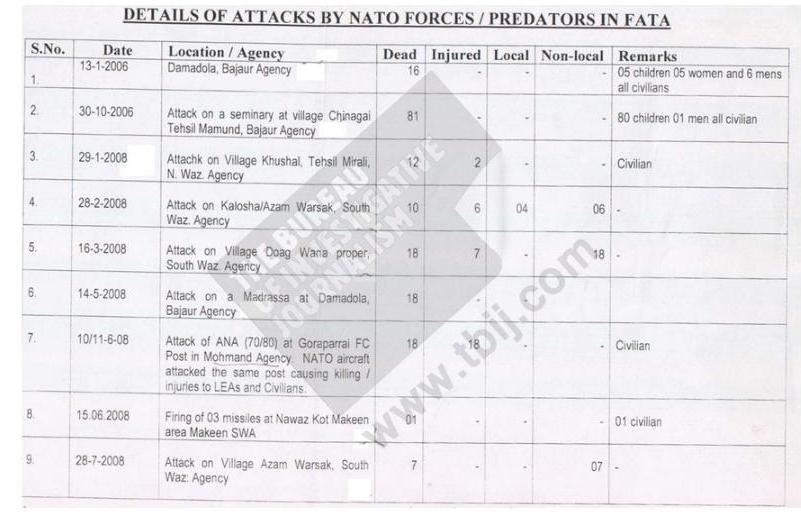
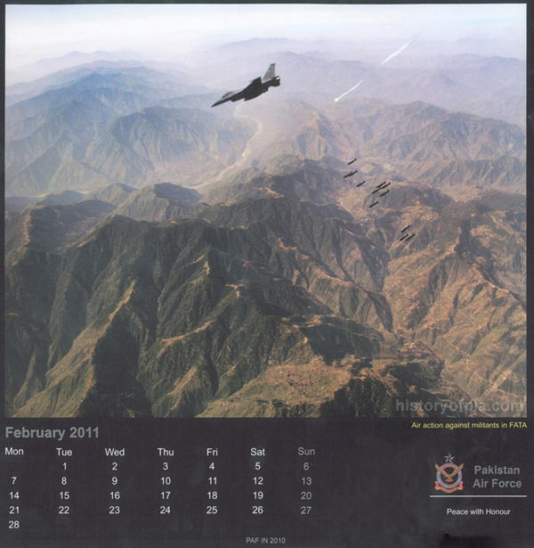
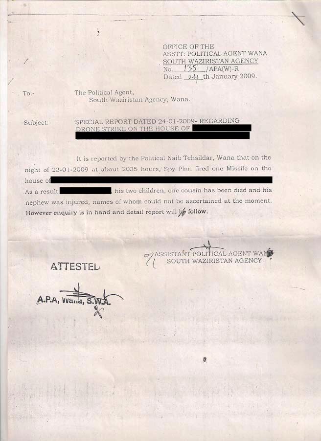
I say this because the US is not the only state carrying out air strikes in the region.  Soon after 9/11 and the US-led invasion of Afghanistan, largely in response to pressure from Washington, the Pakistan military moved into the FATA.  According to Zahid Ali Khan, Pakistan’s Frontier Corps was deployed in December 2001, but by May 2002 it was decided that a much heavier hand was needed and the Pakistan Army was ordered into the borderlands for the first time in the nation’s history.  Local people requested that military operations be limited to ground forces, but by 2004 this agreement was in shreds and – as the image below shows – ever since the Pakistan Air Force has made no secret of its continuing air strikes on the FATA.

PAF air strike in FATA

Again, there is no public tabulation, but the American Enterprise Institute‘s Critical Threats daily Pakistan Security Brief – I know, I know, it’s a neoconservative think-tank – culls this (needless to say, approving) record from reports in Pakistan media in the first two months of this year alone:

25 February PAF kills 10 TTP militants in Tirah [Kurram/Khyber, FATA]

21 February PAF bombs militants in Orakzai [NWF Province] killing 29

19-20 February PAF jets bomb TTP hideouts in Orakzai

11 February PAF jets kill 8 militants in the Tirah Valley

8 February Jets kill 9 militants in Orakzai

7 February PAF targets militants in Orakzai

6 February Jets kill 8 in Orakzai

30 January PAF kills 23 militants in Tirah Valley and 8 in Orakzai agency

28 January Pakistani jets bomb militants in Orakzai

4 January Gunships kill 3, injure more in North Waziristan retaliation

It’s a bare bones summary, clearly, and I suspect the readiness of the AEI to trust local media to report PAF strikes is in stark contrast to their attitude to local reports of US drone strikes.  I’ve also deliberately retained the original phrasing: conspicuously, there is no record of  civilian casualties. Like the United States, Pakistan routinely plays these down or denies them altogether.  Here, for example, is a typical report via the Long War Journal on 25 March 2010:

‘Pakistani fighter-bombers struck a series of targets in the Mamuzai region in [Orakzai] today. Sixty-one Taliban fighters were killed, Pakistani intelligence officials told The Associated Press. The military claimed that no civilians were killed in the attacks. The targets included a madrassa, a mosque, and a seminary run by the Tablighi Jamaat. Pakistani officials said that Taliban leaders were meeting at the Tablighi seminary.’

PAF air strike, Orakzai

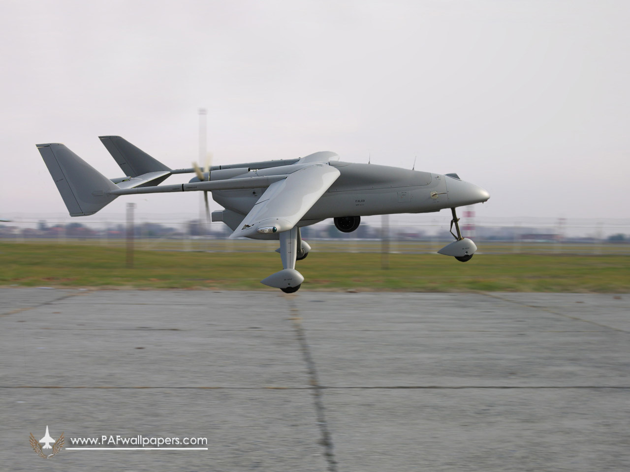
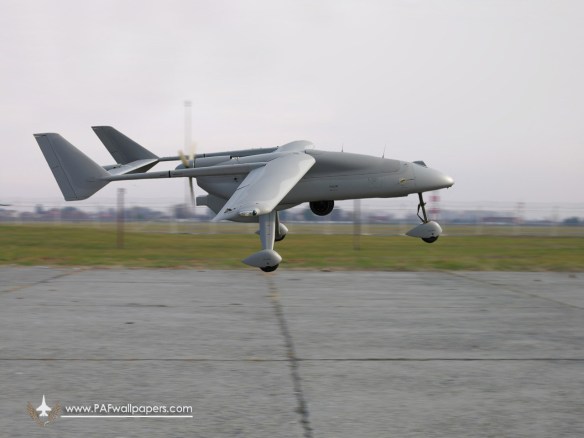
It’s unlikely that civilians were unscathed.  For the first four years at least the accuracy of the Air Force’s strikes was compromised by what Irfan Ahmad described as  its ‘lack of real time electronic intelligence and inferior technical means for command, control and communications’, by deficiencies in the targeting pods used by the PAF’s  ageing F-16 aircraft, and by the use of laser-guided missiles whose precision was reduced by clouds or poor visibility.  From 2008 new electro-optical targeting pods and sensors were being retrofitted and new ground and air capabilities for image exploitation put in place.  In 2009 the Air Force was also the launch customer for the Anglo-Italian Falco reconnaissance drone (see below), which is now co-produced in Pakistan; five systems were soon in use over the FATA, each comprising four aircraft with one held in reserve, and the Air Force was already anticipating arming them ‘with the most modern and lethal payloads’. More recently, the PAF has upgraded its F-16 fleet with new Block 52 versions and installed advanced avionics.  Throughout this period, as the military offensive periodically intensified, hundreds of thousands, perhaps millions of people were displaced from the borderlands.

falco_uav_galileo_avionica_paf_pakistan_air_force_01

It’s difficult to provide a detailed accounting of the air strikes, but in a rare admission former Air Chief Marshall Rao Qamar Suleiman claimed that the Pakistan Air Force carried out 5,000 strike sorties and dropped 11,600 bombs on 4,600 targets in the FATA between May 2008 and November 2011.  Unlike US air strikes in the region, PAF strikes are rarely ‘stand-alone’ affairs but are co-ordinated with ground forces (which is also the case with most drone strikes in Afghanistan, which operate in close concert with troops and conventional strike aircraft).

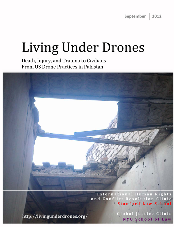
My object is recording all this is (I hope obviously) emphatically not to say that it is perfectly acceptable for the US to launch air strikes in the FATA because Pakistan is doing the same. Rather, the co-existence of the two air campaigns explains, in part, how it is possible for each party to accuse the other of carrying out an attack, as reported earlier this month.  More importantly, it also emphasises the ever-present horizon of danger within which the inhabitants of the borderlands are forced to live.  They are not only Living under drones.

Living Under Drones

The same point was sharpened by CIVIC – now the Center for Civilians in Conflict – in their (I think vital) report Civilian harm and conflict in North West Pakistan, published in October 2010. That report also details the violence meted out to civilians by militant groups in the region; for a detailed survey of the political geography of the borderlands, see Brian Fishman‘s The Battle for Pakistan: militancy and conflict across the FATA and NWFP, produced for the New America Foundation in 2010; there’s also much to think about in Daanish Mustafa and Katherine Brown, ‘Spaces of performative politics and terror in Pakistan‘, and in the same authors’ ‘The Taliban, Public Space and terror in Pakistan‘.

The existence of the two air campaigns also shows that the FATA are produced as a space of exception not only through Washington’s strenuous juggling with the Authorisation to Use Military Force and with international law (to validate the extension of its ‘global battlefield’) – whether it does so with or without Islamabad’s covert consent remains an open question – but also through Islamabad’s continued determination to treat the borderlands as legally anomalous territories for its own assertion of military violence.

ROE Waging war in WaziristanThe last is a doubled colonial legacy.  Not only is the legal geography that structures the FATA’s relations with the Pakistani state a relict from Britain’s imperial decision to treat them as a space to be ‘excepted from state and society for the purposes of war’, as Ian Shaw and Majed Akhter put it in Antipode recently.

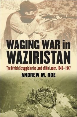
So too is the decision to continue to use the FATA as a laboratory for what the British called ‘air control’. Andrew Roe has provided a series of detailed discussions in the RAF’s invaluable Air Power Review, here and here and here, and brought much of his research together in Waging war in Waziristan (2010).

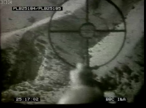
But for a rapid and sobering sense of how these campaigns were viewed from the air in the 1930s you need to watch this BBC interview with Group Captain Robert Lister, Wings over Waziristan, which includes extraordinary cine footage showing what he calls ‘tribal operations from the air’.  Lister was posted to Peshawar in 1935, and soon after he arrived both the Army and the Air Force were ordered to put down ‘a tribal insurrection or rebellion’ in Waziristan.  Their preferred method was to destroy villages by setting fire to individual houses, blowing them up, or bombing them from the air ‘to make them say “Right, it’s not worthwhile – come to terms.”‘  Listen as Lister says, in cut-glass tones, ‘It was a fair and just way of dealing with it: they started these troubles and had to be dealt with.’

Waziristan:Lister:Here's an attack being carried out

And if you want to discover a different dimension to ‘unmanning’ aerial vehicles, listen from 08.00-08.40.

UPDATE: I’ve just discovered another film shot over Waziristan in 1937 by Leonard de Ville Chisman, which covers the air and ground war against the Faqir of Ipi described by Lister.  It contains a number of strikingly similar shots, though there is of course no commentary: you can access it via Colonial Film: Moving Images of the British Empire here.  On that remarkably informative site, Francis Gooding writes:

The official record of NWFP operations during 1936-7 – a thick volume, its size indicating the scale and seriousness of the conflict – contains full details about the manner in which aircraft were employed. The flag marches of November that sparked the revolt were accompanied by aircraft reconnaissance, and the record notes that ‘air reconnaissance requirements were met by one flight of No. 5 (Army Co-operation) Squadron’ (Govt of India, op.cit., 15), and the RAF also provided close cover for troops, and this pattern – reconnaissance with close support against the enemy – was repeated throughout the operations.

Reels 14 and 15 of the Chisman collection record precisely these kinds of encounters and air operations, with footage of bombing raids and the dropping of supplies to forward positions by parachute taken from within flying aircraft. Aircraft were also used to disseminate information and warnings about future punitive action (again, this was a tried and tested method, typical of colonial air policing; see Omissi, 1990, 154-5). On 27 August 1937, for instance, ‘notices were dropped over the Shawal area warning the inhabitants that until the Faqir submitted to Government, any tribe sheltering him would be liable for punishment’ (Govt. of India, op.cit., 179), and reel 15 contains a sequence showing a pilot unfurling a large leaflet, with text in Pashto and Urdu. The following sequences show air-drops of these leaflets over hill country. There are also scenes showing armoured cars and tanks on the move, and a sequence apparently shot during a battle, with a line of artillery opening fire on hill positions. 

The Faqir’s uprising was arguably the most serious colonial insurgency of the inter-war imperial period, and the films are remarkable in that they record scenes of action from a poorly remembered but major guerrilla conflict. Beyond this historical importance they have another significance, for they offer scenes of something only very rarely captured on film, despite its regular occurrence throughout the Empire – the recourse to the punitive deployment of heavy weaponry against subject peoples in revolt.

Naming names

Mexican-poet-Javier-SiciliaIn March 2011 members of a Mexican drug cartel tortured and murdered a young student, Juan Francisco Sicilia Ortega, along with six of his friends in the city of Cuernavaca in Morelos.  His father, Javier Sicilia (right), poet, professor and journalist, later told Time:

‘When I got to Cuernavaca… I was in a lot of emotional pain. But when I arrived at the crematorium I had to deal with the media. I asked the reporters to have some respect; I told them I’d meet them the next day in the city plaza. When I got there I found they’d put a table [for a press conference] out for me, and I realized this was going to be bigger than I’d anticipated.

‘I had never thought of starting a movement or being a spokesman for anything. I’m a poet, and poets are better known for working with more obscure intuitions. But in those moments I was reminded that the life of the soul can be powerful too. My chief intuition then was that we had to give name and form to this tragedy and somehow put that into action with real citizens as a way to tell the government, “We need something new, especially new institutions to fight our lawlessness and corruption and impunity, not just that of the drug cartels but the state.”‘

Sicilia's call

Sicilia’s demand (above) started the Movement for Peace with Justice and Dignity (“Haste la Madre!”), but the call to abjure the aggregations and anonymizations of mass violence – by state and non-state actors – has been taken up in other political arenas too.

It’s in this spirit that I read the Open Society‘s detailed listing of 136 people who were subjected to secret detention or extraordinary rendition by the CIA.

Sth-Wana-letter-Jan-20091And now – to turn to a program that is in many respects the flip side of extraordinary rendition (assuming a dark side can have another dark side) – the Bureau of Investigative Journalism in London has announced an ambitious campaign to identify and name all the victims of US-directed air strikes in Pakistan.

The Bureau’s Chris Woods explains:

‘Part of the justification for the US carrying out drone strikes without consent is their reported success. And naming those militants killed is key to that process. Al Qaeda bomber Fahd al-Quso’s death was widely celebrated.  Yet how many newspapers also registered the death of Mohamed Saleh Al-Suna,  a civilian caught up and killed in a US strike in Yemen on March 30? By showing only one side of the coin, we risk presenting a distorted picture of this new form of warfare. There is an obligation to identify all of those killed…’

And, yes, we also need to recover the names of those killed by other actors too.  None of  them are ‘just “collateral damage” or abstractions’.

The principle is developed more generally by the Every Casualty project of the Oxford Research Group.

The purpose of the Every Casualty (EC) programme is to enhance the technical, legal and institutional capacity, as well as the political will, to record details of every single casualty of armed conflict throughout the world, civilian as well as combatant. Civilian deaths are particularly poorly documented, and often not recorded at all. Where death tolls are limited to purely numerical assessments, exaggerated, politicised claims and counter-claims frequently abound. By contrast, where Western nations are engaged in conflicts, they meticulously record their military dead not as numbers but by name.

Such detailed, verifiable and comprehensive recording when extended to all victims provides both a memorial for posterity and public recognition of our common humanity. Careful and respectful records ensure that the human cost of conflict is better understood and can become an immediately applicable resource for conflict prevention and post-conflict recovery and reconciliation.

Every casualty

But I think it’s probably a mistake to privilege names over numbers: numbers matter too, and  – whatever the legal-humanitarian reasons for recovering the names – they also help us to imagine what the raw numbers mean.  There are other ways of achieving the same end, and they don’t necessarily involve abandoning anonymity.  I’ve never forgotten the final scene in Richard Attenborough‘s film of “Oh, what a lovely war!”; the shot begins with a single white cross and then pans back and back and back, seemingly without end, until the screen is filled with a sea of 100, 000 crosses [start at 2:21].

The twitter of drones

BAFANA Tweet Drone strike in YemenBack in May the Bureau of Investigative Journalism described how local activists were using Twitter and other social media platforms to spread the news of US drone strikes in Yemen.  Haykal Bafana, a lawyer living in San’a, the capital of Yemen, kept up a barrage of tweets recording the ‘covert’ strikes in near real-time, which were then amplified through Facebook and micro-news platforms in the region. You can follow him here.

Haykal Bafana

This is all of a piece with the incorporation of social media into the conduct of late modern war that was evident during Israel’s recent attack on Gaza and, as Noel Sharkey told the Bureau,

‘It is incredible how the same type of technology used by the CIA to kill people with drones in the Yemen, is empowering the Yemenis to tweet the attacks as they are happening. They can send us all pictures and bring us closer to the horror they are experiencing. Technology in the small may eventually bring down the over-use of military technology in the large.’

Josh BegleyDrone strikes are certainly now being made visible across a range of social media platforms, and now comes news – from the wonderful Jorge Amigo – that Josh Begley (whose Drones+ app was serially rejected by Apple) has started tweeting what Jake Heller calls ‘the entire history of US drone strikes’ in Pakistan, Yemen and Somalia as part of a graduate class at NYU, Narrative Lab, which focuses on ‘the impact of interactivity and technology on traditional narrative structure’.  Begley told Heller that, for him, ‘it’s about the way stories are told on new social-media platforms.’

Dronestream

How complete the data series can be is an open question – and the rhetorical impact would be even more devastating if Afghanistan were included – but as you can see from my screen grab above Begley, who started at noon on Tuesday 11 December, tweeted that after twelve hours ‘we’re only at March 2010’…  Follow him at Dronestream here.  And, as Connor Simpson at the Atlantic Wire commented, ‘if this project doesn’t merit an A, we would love to see one that does.’

Drone’s eye view

I expect many readers will remember  that Apple rejected NYU grad student Josh Begley‘s Drones+ app last August.  It did so three times and for a multiplicity of confusing – and frankly shifty – reasons.  Apparently it was neither ‘useful’ nor ‘entertaining’; then it presented ‘excessively objectionable’ content (something to take up with the Pentagon and the CIA, surely?). As Danger Room explained, the app was bare bones stuff:

When a drone strike occurs, Drones+ catalogs it, and presents a map of the area where the strike took place, marked by a pushpin. You can click through to media reports of a given strike that the Bureau of Investigative Reporting compiles, as well as some basic facts about whom the media thinks the strike targeted.

All the more ironic, really, since the US military makes extensive use of smart phone technology – including its own (restricted) apps for the iPhone.  More on that here and here and here.

But for the past several weeks James Bridle – of New Aesthetic fame – has been posting satellite images of the distant places where drone strikes are recorded by the Bureau of Investigative Journalism to Instagram: and, as the image below shows, you can view these on your iPhone…

There are, of course, difficulties in pinpointing the locations of drone strikes– and James is evidently very well aware of them – but on his Dronestagram website he explains his desire to convert abstract targets into physical places in terms that resonate beautifully with the arguments I’m trying to develop in Deadly embrace:

The political and practical possibilities of drone strikes are the consequence of invisible, distancing technologies, and a technologically-disengaged media and society. Foreign wars and foreign bodies have always counted for less, but the technology that was supposed to bring us closer together is used to obscure and obfuscate. We use military technologies like GPS and Kinect for work and play; they continue to be used militarily to maim and kill, ever further away and ever less visibly.

Yet at the same time we are attempting to build a 1:1 map of the world through satellite and surveillance technologies, that does allow us to see these landscapes, should we choose to go there. These technologies are not just for “organising” information, they are also for revealing it, for telling us something new about the world around us, rendering it more clearly.

History, like space, is coproduced by us and our technologies: those technologies include satellite mapping, social photo sharing from handheld devices, and fleets of flying death robots. We should engage with them at every level. These are just images of foreign landscapes, still; yet we have got better at immediacy and intimacy online: perhaps we can be better at empathy too.

You can follow the images here and in much more detail via tumblr here.  More information here.

This comes at an opportune moment since I’ve been talking this week with Susan Schuppli and Eyal Weizman at Forensic Architecture about a collaborative, interactive project to bring together all the available data on drone strikes.