Continuing catastrophes

VP-AlHaq-GazaVillages

At a time when the plight of refugees from the wars in Iraq, Syria, Libya, Somalia and elsewhere is – at last – commanding the attention of a global audience, it’s important not to forget other refugees: including those from Palestine.  Al-Haq, which co-sponsored the infographic above, explains:

August 26, 2015 marked the first anniversary of Israel’s offensive on the Gaza Strip, during which 2,219 Palestinians were killed. However, a large part of the story is left untold. Over half of those killed were refugees who were displaced from their homes in Yafa, Salama, Isdud, and many other villages and towns, as a result of and following the Nakba [‘catastrophe’] in 1948. The majority of those killed lived in refugee camps in the Gaza Strip within a 30 mile (50 km) radius of their homes of origin. A total of 1,236 refugees were killed during the 2014 offensive, including at least 309 children.

This infographic visually represents the untold story of Gaza’s refugees. Created by Visualizing Palestine in collaboration with four Palestinian human rights organizations, Al-Haq, the Al Mezan Centre for Human Rights, the Palestine Centre for Human Rights, and Al-Dameer Association for Human Rights, who launched a joint campaign to document Israel’s attacks during the 2014 offensive against the Gaza Strip.

For Palestinian refugees, the Nakba did not end in 1948, as they have experienced a continued denial of justice. There are 1.3 million refugees residing in Gaza who are spread over eight refugee camps, making up almost three quarters of the total population of the Gaza Stip. Refugees residing in Gaza have faced multiple consequent internal displacements due to Israeli policies, including Israel’s three military offensives against Gaza over the last six years. Israel’s deadly military operations, as well as its eight-year closure of Gaza have had devastating effects on the entire population in Gaza. While all Palestinians in Gaza endure harsh living conditions, including irregular electricity and water supplies, these issues are even more acute in the refugee camps.

You can find the data and other notes on the visualization here.  And if you are wondering about my title, here is Joseph Massad writing in 2008 on ‘Resisting the Nakba‘:

[T]here is much at stake in all of this, in rendering the Nakba an event of the past, a fact on the ground that one cannot but accept, admit, and finally transcend; indeed that in order to move forward, one must leave the Nakba behind. Some have even suggested that if Israel acknowledges and apologizes for the Nakba, the Palestinians would forgive and forget, and the effects of the Nakba would be relegated to historical commemorations, not unlike the one we are having this year.

In my view, the Nakba is none of these things, and the attempt to make this year [2008] the 60th anniversary of the Nakba’s life and death is a grave error. The Nakba is in fact much older than 60 years and it is still with us, pulsating with life and coursing through history by piling up more calamities upon the Palestinian people…  Much as the world would like to present Palestinians as living in a post-Nakba period, I insist that we live thoroughly in Nakba times. What we are doing this year is not an act of commemorating but an act of witnessing the ongoing Nakba that continues to destroy Palestine and the Palestinians. I submit, therefore, that this year is not the 60th anniversary of the Nakba at all, but rather one more year of enduring its brutality; that the history of the Nakba has never been a history of the past but decidedly a history of the present.

The conflict shoreline, colonialism and climate change

Conflict_Shoreline_web

When Eyal Weizman was in Vancouver last March – joining us for Gaston Gordillo‘s  workshop on Space, materiality and violence at the Peter Wall Institute for Advanced Studies – he delivered a public lecture on The Conflict Shoreline: Colonialism as Climate Change.

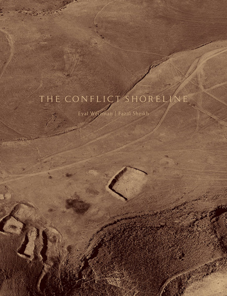
It’s now available as an extended essay (96 pp) from Steidl in association with Cabinet Books:

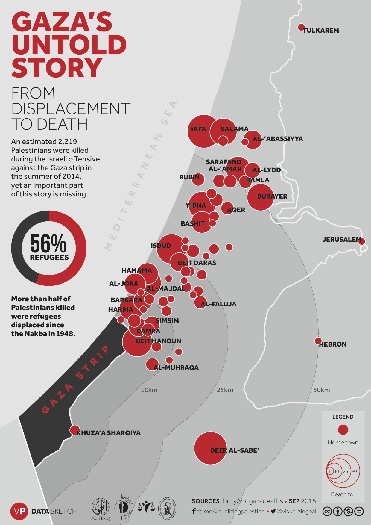
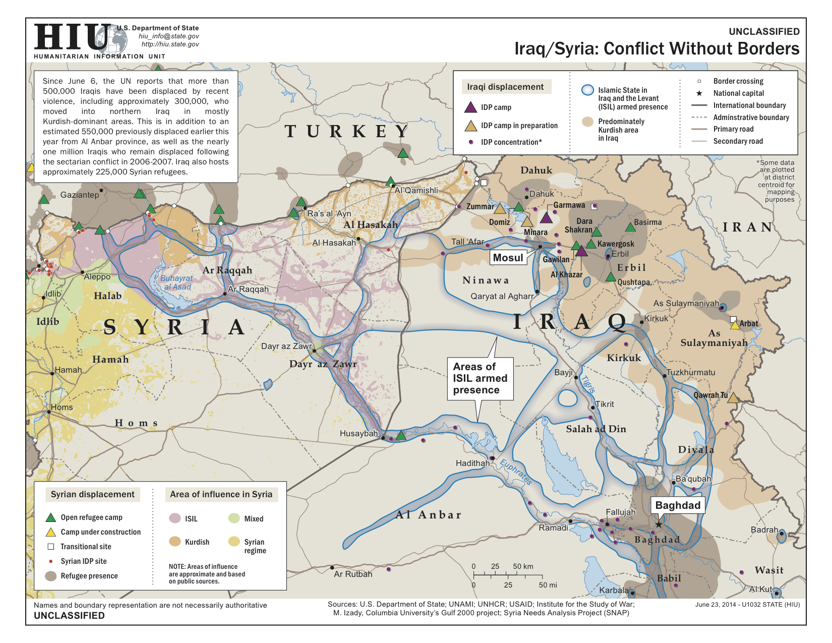
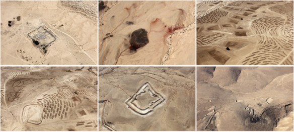
The village of al-‘Araqib has been destroyed and rebuilt more than seventy times in the “battle over the Negev,” an ongoing Israeli state campaign to uproot the Bedouins from the northern threshold of the desert. Unlike other frontiers fought over during the Israel–Palestine conflict, however, this threshold is not demarcated by fences and walls but advances and recedes in response to cultivation, colonization, displacement, urbanization, and climate change.

The fate of al-‘Araqib, like that of other Bedouin villages along the desert’s threshold, its “aridity line,” is bound up with deep environmental changes. But whereas even the most committed environmentalists today conceive of climate change as an accidental and unintentional side effect of modernity, Israeli architect and theorist Eyal Weizman argues that from the point of view of colonial history, climate change has never been simply collateral damage. It has always been a stated goal; “making the desert bloom” is, in effect, “changing the climate.”

In examining this history, Weizman outlines attempts—from the Ottoman era through the period of European colonization to the present—to scientifically define, measure, and map the threshold of the desert. Such efforts have been important because imperial and, later, national governments—whose laws have never recognized property rights in the desert—aimed to push back this threshold as they tried to expand the limits of arable land and bring the nomads under state control. In the Negev, the displacement of the weather and the displacement of the Bedouins have gone hand in hand. But while the desert edge, and the Bedouins, have been driven further and further south, global climate change today acts as a major counterforce. Predictably, the Bedouins are caught in the middle.

Brilliantly researched and argued, Weizman’s text—part detective story, part history lesson, and part scientific analysis—explores the changing threshold of the Negev through the extraordinary contemporary photographs of American artist Fazal Sheikh, as well as an array of documents, maps, and images, including historical aerial imagery, remote sensing data, state plans, court testimonies, and nineteenth-century travelers’ accounts. Together, these disparate forms of evidence establish the “conflict shoreline” as a border along which climate change and political contestation are deeply, perilously entangled.

You can find some of the background, and the relation to Eyal’s Forensic Architecture project, in an interview earlier this year:

I’m mostly trying to establish forensic architecture as a critical field of practice and as an agency that produce and disseminate evidence about war crimes in urban context. Recent forensic investigations in Guatemala and in the Israeli Negev involved the intersection of violence and environmental transformations, even climate change. For trials and truth commissions, we analyze the extent to which environmental transformation intersect with conflict.

The imaging of this previously invisible types of violence—‘environmental violence’ such as land degradation, the destruction of fields and forests (in the tropics), pollution and water diversion, and also long term processes of desertification—we use as new type of evidence of processes dispersed across time and space. There are other conflicts that unfold in relation to climatic and environmental transformations and in particular in relation to environmental scarcity.

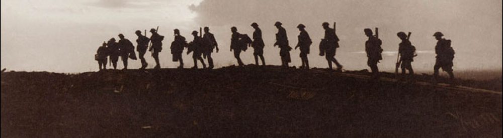
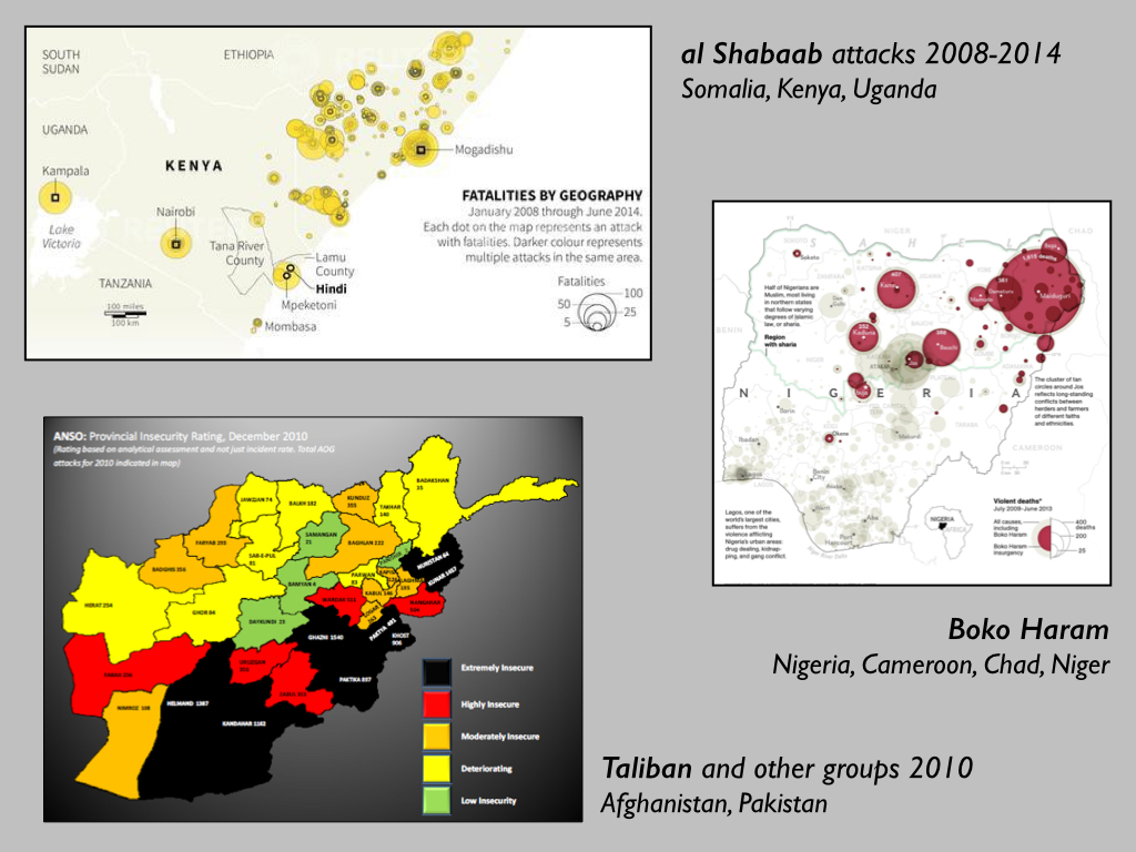
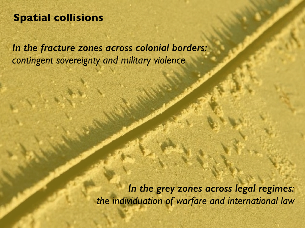
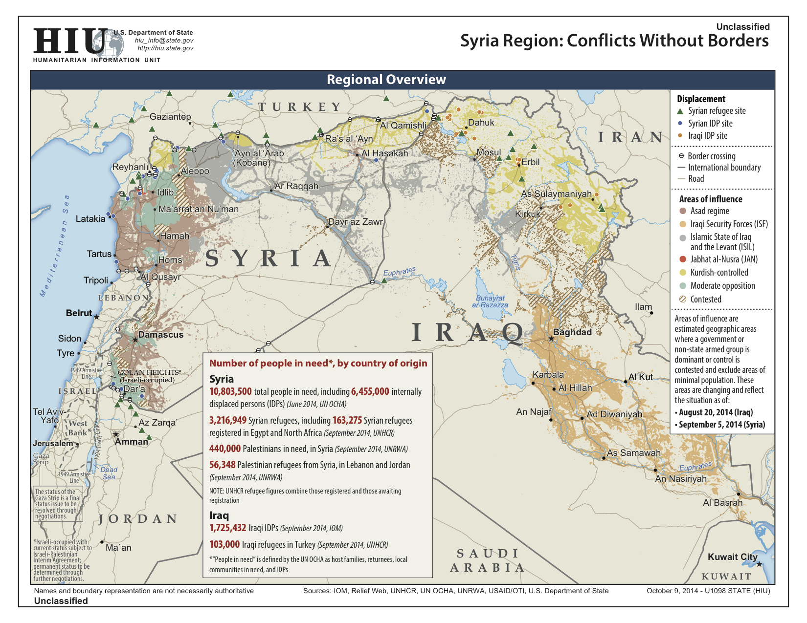
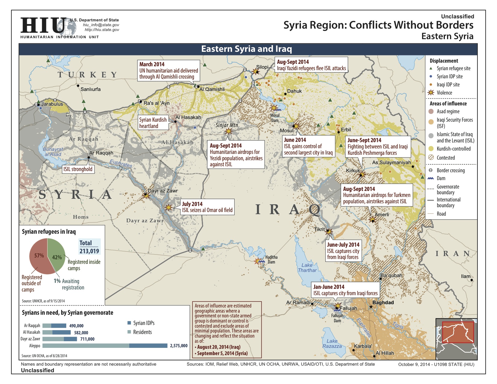
Conflict has reciprocal interaction with environment transformation: environmental change could aggravate conflict, while conflict tends to generate further environmental damage. This has been apparent in Darfur, Sudan where the conflict was aggravated by increased competition over arable due to local land erosion and desertification. War and insurgency have occurred along Sahel—Arabic for ‘shoreline’—on the southern threshold of the Sahara Desert, which is only ebbing as million of hectares of former arable land turn to desert. In past decades, conflicts have broken out in most countries from East to West Africa, along this shoreline: Eritrea, Ethiopia, Somalia, Sudan, Chad, Niger, Mali, Mauritania, and Senegal. In 2011 in the city of Daraa, farmers’ protests, borne out of an extended cycle of droughts, marked the beginning of the Syrian civil war. Similar processes took place in the eastern outskirts of Damascus, Homs, al-Raqqah and along the threshold of the great Syrian and Northern Iraqi Deserts. These transformations impact upon cities, themselves a set of entangled natural/man-made environments. The conflict and hardships along desertification bands compel dispossessed farmers to embark upon increasingly perilous paths of migrations, leading to fast urbanization at the growing outskirts of the cities and slams.

I’m trying to understand these processes across desert thresholds. There has been a very long colonial debate about what is the line beyond which the desert begins. Most commonly it was defined as 200 mm rain per annum. Cartographers were trying to draw it, as it represented, to a certain extent, the limit of imperial control. From this line on, most policing was done through bombing of tribal areas from the air. Since the beginning, the emergence of the use of air power in policing in the post World War I period—aerial control, aerial government—took form in places that were perceived, at the time, as lying beyond the thresholds or edges of the law. The British policing of Iraq, the French in Syria, and Algeria, the Italians in Libya are examples where control would hover in air.

Up to now I was writing about borders that were physical and manmade: walls in the West Bank or Gaza and the siege around it—most notably in Hollow Land (2007). Now I started to write about borders that are made by the interaction of people and the environment—like the desert line—which is not less violent and brutal. The colonial history of Palestine has been an attempt to push the line of the desert south, trying to make it green or bloom—this is in Ben Gurion’s terms—but the origins of this statement are earlier and making the desert green and pushing the line of the desert was also Mussolini’s stated aim. On the other hand, climate change is now pushing that line north.

Following not geopolitical but meteorological borders, helps me cut across a big epistemological problem that confines the writing in international relations or geopolitics within the borders organize your writing. Braudel is an inspiration but, for him, the environment of the Mediterranean is basically cyclically fixed. The problem with geographical determinism is that it takes nature as a given, cyclical, milieu which then affects politics—but I think we are now in a period where politics affects nature in the same way in which nature affects politics. The climate is changing in the same speed as human history.

fazal-sheikh-desert-bloom-web

The conflict shoreline was originally commissioned in response to Fazal Sheikh’s Desert Bloom series (part of his remarkable Erasure trilogy: see image stream above, and also here).

Truth Commission

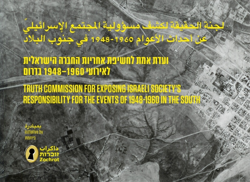
It has also been submitted as evidence for Zochrot‘s project on transitional justice, the Truth Commission on the responsibility of Israeli society for the events of 1948–1960 in the South.

Transitional justice mechanisms address the needs of communities and countries in conflict to cope with systematic abuses and structural injustices in order to facilitate reconciliation. Communities in conflict, both victims and victimizers, have developed a variety of innovative approaches to addressing the needs that result from ongoing conflicts. Hitherto, practices informed by the transitional justice paradigm have been used mainly to accompany and heal societies and communities in political transitions such as from totalitarian to democratic rule, or from an apartheid regime as in South Africa to an egalitarian democratic regime. Usually, these practices have been applied after a violent conflict had ended in a peace agreement, as in the former Yugoslavia, or in an armistice, as in Cyprus or Northern Ireland.

Many activists around the world have demonstrated time and again that silencing and ignoring the past prevent conflict resolution and the attainment of true reconciliation. Therefore, even in situations of seemingly intractable conflicts, several initiatives by civil society organizations, trade union or social religious organizations similar to state-sponsored mechanisms of transitional justice have sprung around the world. For the past 40 years, these initiatives have acted without government backing to bring resolve violent conflicts.

The Truth Commission established by Zochrot now joins these initiatives. The first of its kind in Israel/Palestine, the Commission is unique in that … it is active while the conflict is still ongoing, and against the background of the regime’s evasion of responsibility to the events of the Nakba, which began in 1948 and is still ongoing [the Nakba or ‘catastrophe’ refers to the forced eviction and dispossession of the Palestinian people set in motion by the war of 1948]. The Truth Commission for Exposing Israeli Society’s Responsibility for the Events of 1948-1960 in the South which started its deliberations in late October 2014…

The Commission seeks to expose the events of the Nakba during those years – events that have profound implications for the ongoing Nakba experienced by the Palestinian Bedouins to this day. The Commission examines testimonies by Palestinian displaced persons and refugees, as well as Jews who lived in the south and Jewish fighters who took part in displacement and expulsion operations in the area. In addition, the Commission peruses relevant archive materials. The Commission’s report will be designed to encourage the Jewish society in Israel to accept responsibility for past injustices in the south, with reference to the ongoing Nakba, and for redressing them.

You can also read Tom Pessah‘s report for +972 here.

Base lines and military projections

David Vine has updated his map of the global footprint of the US military over at Politico.

VINE US military bases

I used an early version for my ‘War and Peace’ essay (DOWNLOADS tab), and that map – like this one – was drawn primarily from the annual Base Structure Report, a summary of the US military’s ‘real property inventory’ (all sites owned and managed by the Pentagon).  It’s an unwieldy document which uses a high threshold to filter inclusion:

To qualify for individual entry in the BSR, a DoD site located in the United States must be larger than 10 acres AND have a Plant Replacement Value (PRV) greater than $10 million. If the site is located in a foreign country, it must be larger than 10 acres OR have a PRV greater than $10 million to be shown as a separate entry. Sites that do not meet these criteria are aggregated as an “Other” location within each state or country.

Iraq doesn’t appear in these tabulations – though it is shown on the map – yet the continuing US involvement in the conflict there and across the all-but-erased border in Syria has surely extended its footprint.  As David notes,

‘There were 505 bases at the U.S. occupation’s height, but the Iraqi parliament rejected the Pentagon’s wish to keep 58 “enduring” bases after the 2011 withdrawal. U.S. forces have occupied at least five bases since 2014 and are considering more installations.’

Afghanistan is absent too: ‘By the end of 2014 … the U.S. military will have closed, deconstructed, or vacated most of what were once around 800 military installations, ranging from small checkpoints to larger combat outposts to city-sized bases.’  But the US military retains a significant presence there, and its drones are still based there to support continuing military operations and to attack targets across the border in Pakistan.

There are also strategic omissions.  There’s no mention in the Base Structure Report of Al Udeid Air Base in Qatar, for example, which is the location of US Central Command’s Combined Air and Operations Center.

(You can find more from David on the history of America’s ‘infrastructure for war’ in the Middle East here and on its ‘lily-pad’ strategy here).

There are all sorts of issues involved in measuring a ‘military footprint’ – see my post here and Josh Begley here (who works from the previous year’s Base Structure Report for FY 2013 to produce a radically different visualization) – but for all its uncertainties, David’s map is a sobering snapshot, and he relies on supplementary sources to conclude:

Despite recently closing hundreds of bases in Iraq and Afghanistan, the United States still maintains nearly 800 military bases in more than 70 countries and territories abroad—from giant “Little Americas” to small radar facilities. Britain, France and Russia, by contrast, have about 30 foreign bases combined.

By my calculation, maintaining bases and troops overseas cost $85 to $100 billion in fiscal year 2014; the total with bases and troops in warzones is $160 to $200 billion.

VINE Base Nation

When I first contacted David, his original map formed part of his scorching investigation into Diego Garcia: Island of Shame: the secret history of the US military base on the island of Diego Garcia (Princeton, 2009; paperback 2011: all royalties went to the Chagossians); the new version forms part of an even more ambitious project, Base Nation: how US military bases abroad harm America and the world (Metropolitan Books, 2015):

American military bases encircle the globe. More than two decades after the end of the Cold War, the U.S. still stations its troops at nearly a thousand locations in foreign lands. These bases are usually taken for granted or overlooked entirely, a little-noticed part of the Pentagon’s vast operations. But in an eye-opening account, Base Nation shows that the worldwide network of bases brings with it a panoply of ills–and actually makes the nation less safe in the long run.

As David Vine demonstrates, the overseas bases raise geopolitical tensions and provoke widespread antipathy towards the United States. They also undermine American democratic ideals, pushing the U.S. into partnerships with dictators and perpetuating a system of second-class citizenship in territories like Guam. They breed sexual violence, destroy the environment, and damage local economies. And their financial cost is staggering: though the Pentagon underplays the numbers, Vine’s accounting proves that the bill approaches $100 billion per year.

For many decades, the need for overseas bases has been a quasi-religious dictum of U.S. foreign policy. But in recent years, a bipartisan coalition has finally started to question this conventional wisdom. With the U.S. withdrawing from Afghanistan and ending thirteen years of war, there is no better time to re-examine the tenets of our military strategy. Base Nation is an essential contribution to that debate.

There is a long history of struggles against the presence of US military bases overseas – Catherine Lutz‘s edited collection, The bases of empire: the global struggle against US military posts (New York University Press, 2009) remains an indispensable starting-point.

Of course, the US military is also omnipresent in the United States, with installations in all 50 states and seven territories.  The Base Structure Report includes this summary:

DoD sites JPEG

And these bases have brought their own problems and spawned their own protests too.


Visual occupations and a counter-politics of visuality

Most readers will know Eyal Weizman‘s searing account of the cruel intersections between the politics of visibility and the politics of verticality in occupied Palestine, Hollow Land: Israel’s architecture of occupation.

But there are other, no less intimate and intrusive dimensions to the politics of visibility for a people under military (and civilian) occupation that amount to what Gil Hochberg calls an ‘uneven distribution of “visual rights”‘.  In her brilliant new book from Duke University Press, Visual occupations: violence and visibility in a conflict zone, she explores ‘the political importance of various artistic attempts to redistribute the visible’ (my emphasis) and, in effect, to put in place a counter-politics of visuality.

978-0-8223-5887-9_prIn Visual Occupations Gil Z. Hochberg shows how the Israeli Occupation of Palestine is driven by the unequal access to visual rights, or the right to control what can be seen, how, and from which position. Israel maintains this unequal balance by erasing the history and denying the existence of Palestinians, and by carefully concealing its own militarization. Israeli surveillance of Palestinians, combined with the militarized gaze of Israeli soldiers at places like roadside checkpoints, also serve as tools of dominance. Hochberg analyzes various works by Palestinian and Israeli artists, among them Elia Suleiman, Rula Halawani, Sharif Waked, Ari Folman, and Larry Abramson, whose films, art, and photography challenge the inequity of visual rights by altering, queering, and manipulating dominant modes of representing the conflict. These artists’ creation of new ways of seeing—such as the refusal of Palestinian filmmakers and photographers to show Palestinian suffering or the Israeli artists’ exposure of state manipulated Israeli blindness —offers a crucial gateway, Hochberg suggests, for overcoming and undoing Israel’s militarized dominance and political oppression of Palestinians.

Here’s the Contents List:

Introduction. Visual Politics at a Conflict Zone

Part I. Concealment

1. Visible Invisibility: On Ruins, Erasure, and Haunting
2. From Invisible Spectators to the Spectacle of Terror: Chronicles of a Contested Citizenship

Part II. Surveillance

3. The (Soldier’s) Gaze and the (Palestinian) Body: Power, Fantasy, and Desire in the Militarized Contact Zone
4. Visual Rights and the Prospect of Exchange: The Photographic Event Placed under Duress

Part III. Witnessing

5. “Nothing to Look At”; or, “For Whom Are You Shooting?”: The Imperative to Witness and the Menace of the Global Gaze
6. Shooting War: On Witnessing One’s Failure to See (on Time)

Closing Words

2014_cover_publication_forensisIt’s a compelling book, and I’m struck by another parallel with Eyal’s work.  In Hollow Land Eyal showed the central role that architecture and architects play in Israel’s illegal occupation of the West Bank, but in subsequently developing his collaborative Forensic Architecture project he effectively reverse-engineers architecture’s dominant imaginary to use built forms and spatial formations as a way of revealing prior trajectories of violence to a public forum.  That too is a counter-politics of visuality.

Psycho-geographies of violence

0747590338Will Self‘s series of columns for the Independent on ‘psycho-geography’ attracted considerable attention (they were published between 2003 and 2007 and then collected in the book shown on the left).  In its original form, of course, psychogeography can be traced back to the Lettrist International and the Situationists, and David Pinder‘s Visions of the city: utopianism, power and politics remains one of the most eye-opening introductions to these and similar experiments.

But in today’s Guardian Self turns to a far from utopian prospect to consider what in less avant-garde and more demotic terms would probably also count as a ‘psycho-geography’ of sorts:  ‘We are passive consumers of the pornography of violence‘.

He begins with a devastating imaginative reconstruction of one of the executions carried out by IS/IS/IL: seen not from the point of view of the video-viewing (or not-viewing) public, or even the executioner, but the victim.  He’s aware of the objections:

Surely, at the end of a year in which the public arena has been fully booked for grand guignol, the last thing anyone needs is such an intrusive – and arguably insensitive – speculation? May we not take this opportunity, on the verge of a new year, to sit back, relax, and turn away from the theatre of horrors – not, of course, because we don’t care about all this suffering, all this hideously violent discorporation, but because at least we know this much about ourselves: we may not be the most ethically motivated, caring, community-minded people around; however, we aren’t like them – we aren’t like those men in Raqqa who beat and burn and stone and rape and enslave and shoot and chop and cut: we aren’t evil. And surely, in the opinionated maelstrom we can all at least agree with David Cameron and Barack Obama on this: to cut off someone’s head is an act of such maleficence that it necessarily, in and of itself, renders those who do it evil; if by evil is understood a will-to-absolute-negation, a nihilism that metastasises through the failing body politic, leaving in its necrotic wake only dead-eyed zombies incapable of any authentic feeling.

And yet I wonder: what I wrote above was an active attempt on my part to sympathise with Abdul-Rahman Peter Kassig, Alan Henning, Steven Sotloff, James Foley and David Haines in the last moments of their lives. It was painful to write because I needed to try and put myself in their heads – possibly it was uncomfortable to read for the same reason; yet reading it was also an activity, requiring the translation of marks on page or screen into ideas, images and sensations. Some attempts to understand these perverse and evil actions are similarly engaged, but for the most part our response to the hostage crisis that unfolded over 2014 was necessarily passive. Passive in part because our government wishes to retain its monopoly both on what it sees as the legitimate exercise of violence, and on the prerogative of mercy as well: there will be no ransoms paid for British hostages, while the knife wielded by the man who has been called Jihadi John will be parried – or so they assure us – by targeted air strikes against Islamic State forces, while our “commitment to the region” is re-emphasised in other ways.

So, our passivity – the passivity of civilians who depend on a professional army to assert our moral will, and the passivity in my case – and quite possibly yours – of citizens who have long since recoiled from the spectacle of this interminable conflict worthy of Orwell’s 1984: the so-called “war on terror”.

There’s more – much more – that takes in themes that will be familiar to many readers but here given new urgency by the torsions of Self’s imagination and the sharpness his prose.  It’s an extraordinary ride, and it grips intellectually, politically and ethically.  One of Self’s central arguments is that even as we are reduced to the status of ‘passive consumers’ of this execrable violence (one that is, as he shows, far from absent from our own history) we are – those of us that live in the United States, Canada, the UK, France and elsewhere – also profoundly implicated not only in what is being staged by IS but also in the administration of military violence by the states that make up the latest ‘coalition’.

‘… we are all kneeling in the desert, staring at the serrations on that knife; the very personal and intimate nature of these murderous beheadings calls to our attention – try as we might to repress it – the cold impersonality of the murders committed in our name; for, just as in recent decades the west found it profitable to outsource manufacturing production to low-wage economies, so our own moral accounting has in the short term benefited from a form of outsourcing: western governments no longer find it expedient to perpetrate violence closer to home (it makes for bad PR and restive electorates); yet in a globalised world the exercise of “legitimate” violence is the one monopoly they continue to operate. Perhaps one way of looking at the Middle East is that it’s one of the most productive “bloodshops” we have, a reliable supplier of conflicts that give the west a showroom within which to demonstrate its overwhelming firepower.’

As I say, there’s much, much more, and Self’s reflections on the braiding threads between imagery, passivity , disembodiment and military and paramilitary violence make this the one essay I’d urge everyone to read and reflect on this week, even this month.  And probably all next year.

Conflicts without borders

In Finland last month I gave a presentation on Law, violence and b/ordering, in which I began by making two preliminary points about border crossings and (para)military violence: trans-border incursions and transgressions have been facilitated by (i) new stealth technologies deployed by state actors and (ii)  the rise of new non-state and para-state actors.  Here are the relevant slides:

GREGORY 2 Law, violence and b:ordering.001

GREGORY 2 Law, violence and b:ordering.002

GREGORY 2 Law, violence and b:ordering.003

GREGORY Law, violence and b:ordering.003

I derived the map showing the advance of IS(IS)/ISIL from the Institute for the Study of War; say what you like about their politics (this is the Kagans we are talking about), their maps and summaries are extremely helpful.

Now Public Intelligence has just published a series of (unclassified) maps of Iraq, Syria, Lebanon and Jordan produced by the Humanitarian Information Unit of the US State Department called Conflicts Without Borders:

‘Conflicts Without Borders refers to a conflict in one country that draws in other governments and non-state actors, exacerbates stresses and conflicts in the neighbouring countries, and generates displacement across borders.’

That’s a definition to think about; there are obvious ironies in the US offering a definition that I suspect is intended to exclude its own part in initiating conflicts (if so, it doesn’t work), and there is the interesting attribution of causal powers to conflicts (which ‘draw in’ other actors like so many black holes).

This map series is dated 9 October 2014; the maps provide a Regional Overview (the first map below) and then show Northern Syria and Turkey, Western Syria and Lebanon, Southern Syria and Jordan and Eastern Syria and Iraq (the second map below).

DoS-Syria-ISIL

DoS-Iraq and Syria-ISIL

You can access a single summary map for late June here (shown below):

DoS Iraq Syria Conflict June 2014

Redlining

Poster-RTP-EN-jpeg-723x1024

I’ve posted about maps of this summer’s Israeli assault on Gaza before (see also here), and in the light of those discussions Max Blumenthal‘s testimony before the Extraordinary Session of the Brussels Tribunal on Gaza this past week was exceptionally interesting.  He arrived in Gaza on 15 August, at the start of yet another ‘humanitarian ceasefire’, and recorded testimony from residents from several of the areas destroyed by the Israeli military.

In Shuja’iyya Max and his colleague Dan Cohen discovered a map abandoned by the Israeli military in an ammunition box:

IDF Map Gaza

Over at Alternet, Max reads this map with the aid of Eran Efrati, a veteran of the Israeli army.  Over the last five years Eran has been conducting interviews with Israeli soldiers – since Operation Cast Lead, in fact – and as part of his investigations into the vicious attack on Shuja’iyya he had this to say to Amy Goodman:

‘… in the morning, families are starting to come back into their neighborhood, civilians looking for family members they left behind and looking for them under the rubbles…. People [are] going around the neighborhood and screaming names of family members, looking for them—obviously unarmed civilians. The soldiers are in the house, looking ahead. At that time, they decide to do an imaginary red line in the sand. Our officers tell them they had to do an imaginary red line to determine if they’re in risk or not. And whoever will cross this red line will be a risk for them, and so far, they can kill him. Of course, that’s not something new. It happened in 2009 and in 2012. But this time, this imaginary red line was drawn very, very far from the house. Snipers were sitting on the windows waiting for orders.’

eran efrati

The map Max and Dan found provides further evidence of these ‘red lines’; Max again:

The map you are looking at offers an indication that not only were individual soldiers able to devise their own “invisible” red lines, there was an explicit policy to transform areas of central Shujaiya into free-fire zones where civilians could be killed simply for being present.

In orange, in the upper center of the map, the phrase, “Tzir-Hasuf,” or “We cleared it out,” appears. All homes along this road were destroyed. In fact, most of the homes in the entire area displayed on the map were razed to the ground.

In the upper-right-hand corner of the map, inscribed in red Hebrew letters, you can see the phrase, “Hardufim.” This is code invoked over army radios to indicate soldiers killed in combat. According to Efrati, the phrase was used during Operation Cast Lead to delineate areas where Palestinian civilians could be killed. It appears this line was drawn in Shujaiya after the Golani Brigade lost 13 soldiers during clashes on the evening of the 19th — when “Hardufim” was heard blaring across Israeli army radios — before they occupied homes in Shujaiya the following morning, when the now notorious videotaped execution of 22-year-old Salem Shamaly occurred.

Atlas wept

The Gaza War Map

To grasp the catastrophic scope of destruction in Gaza, there are three new resources of exceptional importance.  First, Lewis Whyld‘s The Gaza War Map: it’s an interactive map keyed to a series of panoramic images which transports you to 20 sites from Beit Hanoun south to Rafeh and it is, appropriately, devastating.

Gaza Crisis Atlas

Second, the UN’s Office for the Coordination of Humanitarian Affairs has released its Gaza Crisis Atlas: 110 pages of maps and high-resolution satellite imagery.  It’s a remarkably systematic survey, whose primary purpose is to assist aid and development agencies in planning and responding to the crisis, but it’s also an indispensable resource for anyone wanting to grasp the intensity of the prolonged Israeli assault on Gaza and its people.  The text and captions are available in eight languages, and you can zoom and print individual pages.

Finally, there’s MediaTown‘s drone-shot video of the destruction of Al-Shejaiya; its brevity does not sacrifice its impact:

Even hardened US military officers were stunned by the unrelenting and indiscriminate nature of the bombardment.  Throughout the offensive the Pentagon compiled reports twice a day on Israeli military operations, and according to a summary of the barrage on 20-21 July ’11 Israeli artillery battalions …  pumped at least 7,000 high explosive shells into the Gaza neighborhood, which included a barrage of some 4,800 shells during a seven-hour period at the height of the operation…’

That amounts to shelling Al-Shejaiya every six seconds FOR SEVEN HOURS (more from Kerry-anne Mendoza among the ruins of Al-Shejaiya here, and more imagery from Occupied Palestine here).

Al-Jazeera reports:

“Eleven battalions of IDF artillery is equivalent to the artillery we deploy to support two divisions of U.S. infantry,” a senior Pentagon officer with access to the daily briefings said. “That’s a massive amount of firepower, and it’s absolutely deadly.” Another officer, a retired artillery commander who served in Iraq, said the Pentagon’s assessment might well have underestimated the firepower the IDF brought to bear on Shujaiya. “This is the equivalent of the artillery we deploy to support a full corps,” he said. “It’s just a huge number of weapons.”

Artillery pieces used during the operation included a mix of Soltam M71 guns and U.S.-manufactured Paladin M109s (a 155-mm howitzer), each of which can fire three shells per minute. “The only possible reason for doing that is to kill a lot of people in as short a period of time as possible,” said the senior U.S. military officer. “It’s not mowing the lawn,” he added, referring to a popular IDF term for periodic military operations against Hamas in Gaza. “It’s removing the topsoil.”

“Holy bejeezus,” exclaimed retired Lt. Gen. Robert Gard when told the numbers of artillery pieces and rounds fired during the July 21 action. “That rate of fire over that period of time is astonishing. If the figures are even half right, Israel’s response was absolutely disproportionate.” A West Point graduate who is a veteran of two wars and is the chairman of the Center for Arms Control and Non-Proliferation in Washington, D.C., he added that even if Israeli artillery units fired guided munitions, it would have made little difference.’

Before I let Gard continue, it’s important to remember that the onslaught did not end that night.  Here is a remarkable video which shows the shelling of Shejaiya market on 30 July (more updates and images from #shejaia here).  Imagery of Shejaiya before and after the bombardment was distributed to Israeli soldiers in Brigade 828 as ‘a victory momento‘ and spur to maintain their ‘fighting spirit’.

Gard goes on to explain the circular error probable (CEP) of munitions and the blast and fragmentation or ‘kill radius’, which I’ve discussed here (scroll down for the ‘kill radius’):

Even the most sophisticated munitions have a circular area of probability, Gard explained, with a certain percentage of shells landing dozens or even hundreds of feet from intended targets. Highly trained artillery commanders know this and compensate for their misses by firing more shells. So if even 10 percent of the shells fired at combatants in Shujaiya landed close to but did not hit their targets — a higher than average rate of accuracy — that would have meant at least 700 lethal shells landing among the civilian population of Shujaiya during the night of July 20 into June 21. And the kill radius of even the most precisely targeted 155-mm shell is 164 feet. Put another way, as Gard said, “precision weapons aren’t all that precise.”

Senior U.S. officers who are familiar with the battle and Israeli artillery operations, which are modeled on U.S. doctrine, assessed that, given that rate of artillery fire into Shujaiya, IDF commanders were not precisely targeting Palestinian military formations as much as laying down an indiscriminate barrage aimed at cratering the neighborhood. The cratering operation was designed to collapse the Hamas tunnels discovered when IDF ground units came under fire in the neighborhood. Initially, said the senior Pentagon officer, Israel’s artillery used “suppressing fire to protect their forward units but then poured in everything they had, in a kind of walking barrage. Suppressing fire is perfectly defensible. A walking barrage isn’t.”

The implication of those closing remarks is that such an indiscriminate barrage is a clear violation of international humanitarian law: and the epic scale of that violation is made clear in the maps, imagery and video I’ve cited here.  It also amounts to collective punishment of a whole community, so it comes as no surprise to discover that the Israeli Supreme Court (‘sitting as the High Court of Justice’ – a phrase that has the same moral resonance as the Israeli Defence Force) has recently endorsed the ‘deterrent function’ of collective punishment (even though it too is prohibited under international humanitarian law).  But even the Court insisted that such a measure had to be ‘proportionate’.

All of this is much on my mind as I head to a meeting in Oulu, Finland, where I’ll be talking about ‘Trans-border transgressions: legal geographies and spaces of exception’.   The case studies on which I’ll draw are the Federally Administered Tribal Areas of Pakistan (mainly Waziristan) and Gaza.  More soon.

Problematizing Cyber-Wars

Cyber OrientI’ve just received a Call For Papers on Problematizing Cyber-Wars for a special issue of CyberOrient: Online Journal of the Virtual Middle East.  The Guest Editor for the issue is the amazing Helga Tawil-Souri, whose work has done so much to illuminate these issues already and who starts in January as the new Director of NYU’s Hagop Kevorkian Center for Near Eastern Studies [more on Helga’s work, with links to her writing and other projects, here].

According to military analysts, since the 1991 Gulf War and even more so since the Hezbollah-Israel 2006 war, we have entered a new phase of warfare, in which kinetic and traditional military power are losing importance to symbolic and media power. Perhaps unsurprisingly given a still-widely held Orientalist view in military circles, many such perspectives revolve around wars and conflicts in the ‘Middle East’ or against ‘Islam’ more broadly – taking place in Iraq, Iran, Afghanistan, Israel/Palestine, Syria, but also on cyber networks and mobile phones. 


While these claims are of course hyperbole, this special issue of CyberOrient invites articles on questions of how we might define wars in a (new) media-age in the region; whether, why, and how (new) media are increasingly sites of warfare; the relationships between ‘virtual’ and ‘real’ battlespaces. Topics could include the significance of targeting (and bombing) telecommunications and media infrastructures; the use of (new) media as outlets for propaganda during wartime; the mediatization of war and the militarization of media; the role of participatory or social media and mobile communications during and in wars; relationships or differences between official, military, alternative, citizen, and grass-roots (new) media uses during war and conflict; the expanding definition of warzones; commemoration and memorialization of war in a digital age; among others. We welcome submissions from across disciplines and methodological approaches that are empirically and critically grounded.

IDF tweet re Hamas Twitter account

[In relation to the IDF tweet (above), from earlier this year, Twitter hasn’t suspended the all too obviously fake ‘Hamas Global PR’ here…]

CyberOrient is a peer-reviewed journal published by the American Anthropological Association, in collaboration with the Faculty of Arts of Charles University in Prague. The aim of the journal is to provide research and theoretical considerations on the representation of Islam and the Middle East, the very areas that used to be styled as an “Orient”, in cyberspace, as well as the impact of the internet and new media in Muslim and Middle Eastern contexts.

Submission

Articles should be submitted directly to Helga Tawil-Souri (helga@nyu.edu) and Vit Sisler (vit.sisler@ff.cuni.cz) by 30 September 2014 (Full Papers). Articles should
be between 6,000 and 8,000 words (including references), and follow the AAA style in referencing and citations. Upon acceptance, articles will be published online with free access in spring 2015.

More information can be found here.

UPDATE:  With exquisite timing, Mondoweiss has just published Rebecca Stein‘s analysis of ‘How Israel militarized social media’:

‘What’s been lost in this coverage – in this story of surprise — is the history of the Israel’s army presence on social media. For in fact, the military’s move to social media as a public relations platform has been rife with improvisation and failure, a process that runs counter to IDF narratives about its innovative work in this regard (the IDF lauding itself as a military early adopter). The army’s interest in the wartime potential of social media can be traced to the first few days of the 2008-2009 Gaza incursion….

In the years that followed, the IDF investment in social media would grow exponentially both in budgetary and manpower allocations, building on this ostensible wartime triumph.

But the process was rife with challenges and missteps.’

You can also find more detail in my previous posts here and here.

Primer on Palestine

MERIP 2014The indispensable Middle East Research and Information Project (MERIP) has just published a new edition of its brilliant Primer on Palestine, Israel and the Arab-Israeli Conflict by Joel Beinin and Lisa Hajjar.  It was first published in 1991 and updated in 2001.

The new edition is available as an open access publication online (and you can also download it as a pdf) here (16pp).  It’s succinct, sharp and savvy – and excellent for teaching.

The Primer includes one of Dutch cartographer Jan de Jong‘s meticulous maps tracing the expansion of illegal Israeli settlements, originally produced for the equally indispensable Foundation for Middle East Peace: you can follow their regular Settlement Reports here.