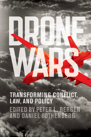
Next month Cambridge University Press is publishing a book of essays edited by Peter Bergen and Daniel Rothenberg, Drone wars: transforming conflict, law and policy, due out from Cambridge University Press at the end of the year. Here’s the blurb:
Drones are the iconic military technology of many of today’s most pressing conflicts, a lens through which U.S. foreign policy is understood, and a means for discussing key issues regarding the laws of war and the changing nature of global politics. Drones have captured the public imagination, partly because they project lethal force in a manner that challenges accepted rules, norms, and moral understandings. Drone Wars presents a series of essays by legal scholars, journalists, government officials, military analysts, social scientists, and foreign policy experts. It addresses drones’ impact on the ground, how their use adheres to and challenges the laws of war, their relationship to complex policy challenges, and the ways they help us understand the future of war. The book is a diverse and comprehensive interdisciplinary perspective on drones that covers important debates on targeted killing and civilian casualties, presents key data on drone deployment, and offers new ideas on their historical development, significance, and impact on law and policy. Drone Wars documents the current state of the field at an important moment in history when new military technologies are transforming how war is practiced by the United States and, increasingly, by other states and by non-state actors around the world.
And here is the Contents List:
Part I. Drones on the Ground:
1. My guards absolutely feared drones: reflections on being held captive for seven months by the Taliban David Rohde
2. The decade of the drone: analyzing CIA drone attacks, casualties, and policy Peter Bergen and Jennifer Rowland
3. Just trust us: the need to know more about the civilian impact of US drone strikes Sarah Holewinski
4. The boundaries of war?: Assessing the impact of drone strikes in Yemen Christopher Swift
5. What do Pakistanis really think about drones? Saba Imtiaz
Part II. Drones and the Laws of War:
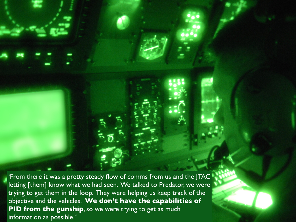
6. It is war at a very intimate level USAF pilot
7. This is not war by machine Charles Blanchard
8. Regulating drones: are targeted killings by drones outside traditional battlefields legal? William Banks
9. A move within the shadows: will JSOC’s control of drones improve policy? Naureen Shah
10. Defending the drones: Harold Koh and the evolution of US policy Tara McKelvey Part III. Drones and Policy Challenges:
11. ‘Bring on the magic’: using drones in combat Michael Waltz
12. The five deadly flaws of talking about emerging military technologies and the need for new approaches to law, ethics, and war P. W. Singer
13. Drones and cognitive dissonance Rosa Brooks
14. Predator effect: a phenomenon unique to the war on terror Meg Braun
15. Disciplining drone strikes: just war in the context of counterterrorism David True
16. World of drones: the global proliferation of drone technology Peter Bergen and Jennifer Rowland
Part IV. Drones and the Future of Warfare:
17. No one feels safe Adam Khan
18. ‘Drones’ now and what to expect over the next ten years Werner Dahm
19. From Orville Wright to September 11: what the history of drone technology says about the future Konstantin Kakaes
20. Drones and the dilemma of modern warfare Richard Pildes and Samuel Issacharoff
21. How to manage drones, transformative technologies, the evolving nature of conflict and the inadequacy of current systems of law Brad Allenby
22. Drones and the emergence of data-driven warfare Daniel Rothenberg
Over at Foreign Policy you can find an early version of Chapter 6, which is an interview with a drone pilot conducted by Daniel Rothenberg. There are two passages in the interview that reinforce the sense of the bifurcated world inhabited by drone crews that I described in ‘From a view to a kill’ and ‘Drone geographies’ (DOWNLOADS tab). On the one side the pilot confirms the inculcation of an intimacy with ground troops, particularly when the platforms are tasked to provide Close Air Support, which is in some degree both reciprocal and verbal:
“Because of the length of time that you’re over any certain area you’re able to engage in lengthy communications with individuals on the ground. You build relationships. Things are a little more personal in an RPA than in an aircraft that’s up for just a few hours. When you’re talking to that twenty year old with the rifle for twenty-plus hours at a time, maybe for weeks, you build a relationship. And with that, there’s an emotional attachment to those individuals.
“You see them on a screen. That can only happen because of the amount of time you’re on station. I have a buddy who was actually able to make contact with his son’s friend over in the AOR [area of responsibility]. If you don’t think that’s going to make you focus, then I don’t know what will.
“Many individuals that have been over there have said, ‘You know, we were really happy to see you show up’; ‘We knew that you were going to keep us from being flanked’; ‘We felt confident in our ability to move this convoy from ‘A’ to ‘B’ because you were there.’ The guy on the ground and the woman on the ground see how effective we are. And it gives them more confidence.”
[The image above is taken from my ‘Angry Eyes’ presentation; the Predator pilot in this instance was involved in orchestrating the air strike in Uruzgan province, Afghanistan on 21 February 2010, and the quotation is taken from the US Army investigation into the incident. I’m converting the presentation into the final chapter for The everywhere war, and I’ll post the draft as soon as I’m finished.]
But when the pilot in Rothenberg’s interview goes on to claim that ‘Targeting with RPAs is very intimate’ and that ‘It is war at a very intimate level’, he reveals on the other side an altogether different sense of intimacy: one that is strictly one-sided, limited to the visual, and which resides in a more abstracted view:
“Flying an RPA, you start to understand people in other countries based on their day-to-day patterns of life. A person wakes up, they do this, they greet their friends this way, etc. You become immersed in their life. You feel like you’re a part of what they’re doing every single day. So, even if you’re not emotionally engaged with those individuals, you become a little bit attached. I’ve learned about Afghan culture this way. You see their interactions. You’re studying them. You see everything.”
The distinction isn’t elaborated, but the claims of ‘immersion’ and becoming ‘part of what they’re doing every day’ are simply astonishing, no? You can find more on the voyeurism of ‘pattern of life analysis’ and the remarkable conceit that ‘you see everything’ here.
[The image above is taken from my ‘Drone geographies’ presentation]
The interview emphasises a different bifurcation, which revolves around the alternation between ‘work’ and ‘home’ when remote operations are conducted from the United States:
“”When you’re doing RPA operations, you’re mentally there, wherever there is. You’re flying the mission. You’re talking to folks on the ground. You’re involved in kinetic strikes. Then you step out the ground control station (GCS) and you’re not there anymore…
“Those are two very, very different worlds. And you’re in and out of those worlds daily. I have to combine those two worlds. Every single day. Multiple times a day. So, I am there and then I am not there and then I am there again. The time between leaving the GCS [Ground Control Station] and, say, having lunch with my wife could be as little as ten minutes. It’s really that fast.”
You can find much more on these bifurcations in my detailed commentary on Grégoire Chamayou‘s Théorie du dronehere and in ‘Drone geographies’ (DOWNLOADS tab).
There’s one final point to sharpen. In my developing work on militarized vision, and especially the ‘Angry eyes’ presentation/essay, I’ve tried to widen the focus beyond the strikes carried out by Predators and Reapers to address the role they play in networked operations where the strikes are carried out by conventional strike aircraft. Here is what Rothenberg’s pilot says about what I’ve called the administrationof military violence (where, as David Nally taught me an age ago, ‘administration’ has an appropriately double meaning):
‘”Flying an RPA is more like being a manager than flying a traditional manned aircraft, where a lot of times your focus is on keeping the shiny side up; keeping the wings level, putting the aircraft where it needs to be to accomplish the mission. In the RPA world, you’re managing multiple assets and you’re involved with the other platforms using the information coming off of your aircraft.
“You could use the term ‘orchestrating’; you are helping to orchestrate an operation.”
***
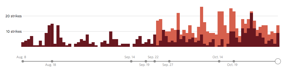
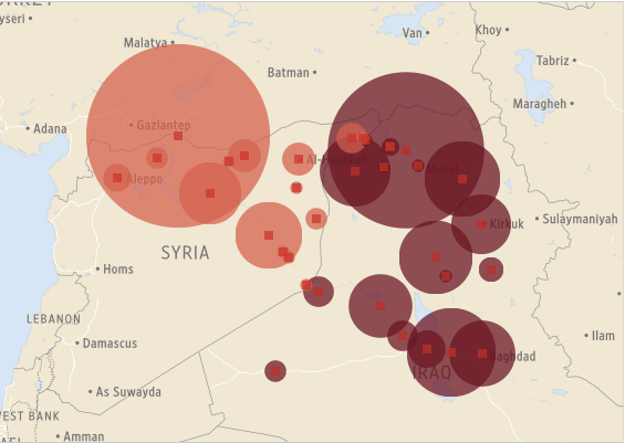
Drone wars appears just as remote operations over Iraq and Syria are ramping up: you can find an excellent review by Chris Coleat Drone Wars UKhere, ‘Drones in Iraq and Syria: What we know and what we don’t.’ The images below are from the Wall Street Journal‘s interactive showing all air strikes reported by US Central Command 8 August through 3 November 2014:
During this period 769 coalition air strikes were reported: 434 in Syria (the dark columns), including 217 on the besieged border city of Kobane, and 335 in Iraq (the light columns), including 157 on Mosul and the Mosul Dam.
But bear in mind these figures are for all air strikes and do not distinguish between those carried out directly by drones and those carried out by conventional strike aircraft. As Chris emphasises:
‘Since the start of the bombing campaign, US drones have undertaken both surveillance and strike missions in Iraq and Syria but military spokespeople have refused to give details about which aircraft are undertaking which strikes repeatedly using the formula “US military forces used attack, fighter, bomber and remotely-piloted aircraft to conduct airstrikes.”’
Although the USAF has used a mix of MQ-1 (Predator) and MQ-9 (Reaper) drones, F-15E, F-16, F/A-18 and F-22 fighters, B-1 bombers, AC-130 gunships and AH-64 Apache helicopters in these operations, it seems likely that its capacity to use remote platforms to provide intelligence, surveillance and reconnaissance is limited by its continuing commitments in Afghanistan (though Britain’s Royal Air Force has now deployed its Reapers for operations in both Iraq and Syria).
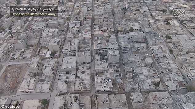
IS (Islamic State) claims to have its own drones too. In February it released video of its aerial surveillance of Fallujah in Iraq, taken from a DJI Phantom FC40 quadcopter, in August it released video of Taqba air base in Syria taken from the same platform, tagged as ‘a drone of the Islamic State army’, and in September a propaganda video featuring hostage John Cantile showed similar footage of Kobane (below).
These image streams are all from commercial surveillance drones, but in September the Iranian news agency Farsreported that Hezbollah had launched an air strike from Lebanon against a command centre of the al-Nursra Front outside Arsal in Syria using an armed (obviously Iranian) drone.
You can find Peter Bergen’s and Emily Schneider‘s view on those developments here, and a recent survey of the proliferation of drone technologies among non-state actors here.
The details of both the state and non-state air strikes remain murky, but I doubt that much ‘intimacy’ is claimed for any of them.
Jean-Baptiste Jeangène Vilmer writes to say that his review of Grégoire Chamayou‘s Théorie du drone has just appeared in English translation over at Books & Ideashere.
It’s a combative review, literally so:
When Chamayou was asked what motivated him to write the book, he replied that “some philosophers in the United States and in Israel work hand in hand with the military to elaborate what I call a ‘necro-ethics’ that tries to justify targeted assassinations. So it is urgent to respond. When ethics is brought into a war, philosophy becomes a battlefield.”
A bit like Plato looking upon his Socratic dialogues as the philosopher’s responses to the sophists – i.e. to false philosophers – Chamayou presents his Theory of the Drone as a response to the traitorous philosophers who collaborate with the military. I am myself one of this low species: I teach ethics and the law of war to officer students at the French Military Academy of Saint-Cyr, and I often work with the military (without however being “enlisted” to justify anything whatsoever). Therefore I can testify that, when you take an interest in military matters, it is helpful to work with them, to increase your precision and to avoid some clichés and factual errors.
I provided some background to Vilmer’s work and discussed his critique here.
An excellent English translation of Theory of the Drone is due from the New Press in December.
While I’m on the subject of translations, French versions of my ‘Drone geographies’ from Radical Philosophy (DOWNLOADS tab) are now available as ‘Géographes du drone’ in Jef Klak: critique sociale et experiences littéraires 1 (2014) 262-277 and in Décadrages: Cinéma, à travers champs 26-27 (2014) 129-150.
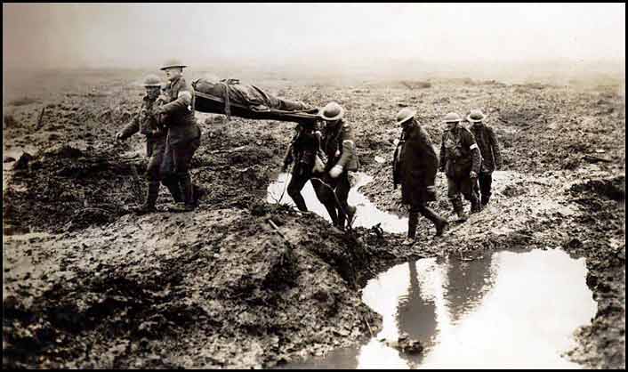
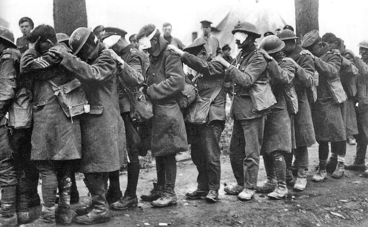
The no-man’s lands of the First World War were never limited to the killing fields between the trenches. Their impact was never fully confined by the time and space of the battles: it lingered on the bodies of soldiers, in contaminated ecologies and in the radically altered post-war intellectual landscape. The violence that is unleashed in the no-man’s land and the destruction it wrought does not result in emptiness, in a terra nullius, but in excess that can never be fully contained.
This session invites additional reflections on the excessive quality of no-man’s land: its materialities, ecologies, cultural expressions and political-ideological articulations. It aims to deepen the theoretical import and conceptual power of ‘no-man’s land’, and move beyond its use as merely a convenient colloquialism. Similarly, we seek to engagements with other histories of no-man’s lands that are not solely confined to the Western Front during WWI.
Despite that last sentence, this is what I’ve come up with; these abstracts are always promissory notes, of course, written so far in advance that they can provide little real indication of what eventually transpires. Fortunately we are now no longer lumbered with the Yellow Pages-style book of abstracts so I doubt anybody will actually read this on the day. But here goes:
Journeys From No Man’s Land, 1914-1918
During the First World War on the Western Front a central logistical preoccupation of military planners was the deployment of troops to the front line and the evacuation of casualties from the battlefield. These priorities were closely connected – the aim was to provide medical treatment as close to the site of the wound as possible so that troops could be returned expeditiously to the line – but they also often confounded one another as hospital trains headed for the coast were shunted into sidings to allow troop trains to move up. In this presentation I address three questions. First, what it was possible to know about the ‘lie of the land’, particularly in the deadly spaces between the front-line trenches? Here I focus on the connections between aerial reconnaissance, night patrols and trench maps. A second question concerns the arrangements made in advance of major offensives – the disposition of stretcher bearers and aid posts, field ambulances and casualty clearing stations – and the ways in which these visible geometries of the medical-military machine affected the sensibilities of soldiers waiting to go ‘over the top’. Finally, how did the wounded apprehend and navigate No Man’s Land, and how did they make what Emily Mayhew calls their precarious journeys away from the fighting?
There’ll be more posts on this as I circle in towards the presentation. It’s part of my new research project which explores military-medical machines and the casualties of war 1914-2014, but which is now widening to include other aspects of medical care in contemporary conflict zones like Gaza and Iraq/Syria and the militarisation of medical intervention in West Africa.
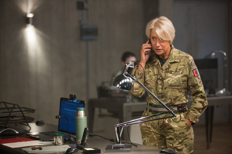
Several years ago I met Guy Hibbert in a London hotel to discuss his draft script for a BBC drama about a targeted killing by a British drone in East Africa. It was a clever script and an interesting conversation – and I hope a helpful one – but in the interim I heard no more about it and assumed that the BBC had shelved the project.
Now I see that Eye in the Sky is in production as a feature film directed by Gavin Hood and starring Helen Mirren (swoon). As First Showingreports,
An American drone pilot (Aaron Paul) finds himself at a crossroads when a 9-year-old girl enters the kill zone his drone operation, under the command of military intelligence officer Col. Katherine Powell (Helen Mirren) is poised to destroy after they learn their targets are planning a suicide mission. What follows is a climb up the “kill chain” of command, weighing the legality and morality of action and inaction.
Eye in the Sky is scheduled for release next year.
UPDATE: Guy has written to say that shooting in Cape Town finishes this week, and then it’s nine months of post-production for a September 2015 première.
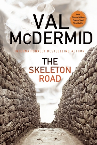
One of my pleasures is good – and I mean seriously good – crime fiction, and I’ve just finished Val McDermid‘s latest, Skeleton Road. It’s a finely wrought reflection on the wars that destroyed the former Yugoslavia, notably the conflict between Serbia and Croatia, but it’s also shot through with ferociously smart insights into geopolitics.
In fact, the epigraph is from Gerard Toal‘s Critical Geopolitics (the book not the blog) and in her acknowledgements Val thanks both Linda McDowelland Jo Sharp.
I was particularly taken by the way in which the shadows (and lights) of international law and human geography fall across its pages. Neither becomes an abstraction; both are fully embodied. Two of the protagonists are lawyers working for the International Criminal Tribunal for the Former Yugoslavia and another is a Professor of Geography at Oxford (who ‘forced herself to consider the entries she was due to contribute to the forthcoming Dictionary of Human Geography‘ – a perfectly reasonable motive for murder).
All of which may explain my favourite quotation from what is now one of my favourite novels. I’ve always despaired of those approaches to ‘geography and literature’ that gut novels by ripping out the supposedly ‘geographical’ bits, so I hope I’ll be forgiven for this autopsic deviation. This is Maggie Blake, Professor of Geography, describing the results of her fieldwork in Dubrovnik:
‘The work I ended up doing on the region and its wars … is rooted, as human geography should be, in an embodiment of the conflict.’
Writing about the sensory armature of modern war seems to have two dimensions (and as usual it’s the relationship between them that matters). One involves the political technologies used by advanced militaries to detect the physical presence of their enemies: the infrared sensors that form part of the multispectral targeting systems fitted to Predators and Reapers that can detect heat signatures of bodies, other sensors that can detect ‘chemical signatures’ associated with IED factories, and sophisticated signals monitoring equipment. These are all prosthetic devices that extend the range of the human sensorium – though they also depend upon it – so that the other dimension, which remains stubbornly important even in later modern war, is constituted by the human body and its own sensory capabilities. This was the central concern of the conference on Sensing War held over the summer, and you can find the abstracts from the meeting here (I particularly like the remark made by a Bundeswehr officer reported by Marion Naeser-Lather: ‘To understand Afghanistan, you have to see, hear, smell and taste it’). It’s also a central theme of my lecture/essay on ‘The natures of war’.
While I was in Zurich I had a lively and productive discussion about the penultimate draft of that essay with Benedikt Korf, Timothy Raeymaekers, Rory Rowan and their students, and as a result of that, together with an e-conversation with Steve Legg, I’ve been re-thinking my previous ideas about corpography. Steve drew my attention to the ways in which I describe senses being ‘out of place’ on the Western Front: tasting rather than feeling mud, for example, or feeling rather than hearing shell-fire. You can find further examples in the extracts from the essay I’ve posted about the war in Vietnam here and here. This scrambling of the senses seems to be different from the intersensoriality discussed by Concordia’s innovative Centre for Sensory Studies.
In response to a similar observation in Zurich, I suggested that the Enlightenment project involved a disciplining of the senses – establishing what it was permissible to see, to hear, to touch, to taste or to smell – and allocating epistemologies to each: what it was possible to know from seeing, hearing, and the rest. And that perhaps these regulated divisions were undone and their epistemologies radically challenged by the intensity of experience on the battlefield.
Since then I’ve stumbled upon the wonderful work of Matt Leonard; see, for example, his exquisitely titled essay on the First World War, ‘A senseless war‘, in which he argues that
‘The Western Front was a world that could not be negotiated by temporarily reordering the operation of our senses, for the ‘temporary’ became a relative term in the hell of the trenches. Rather, the relationship with the environment had to be completely restructured.’
See also his splendid essay on ‘Mud in World War I’ from Military historyhere.
I’ve also discovered a literature on the history of the senses that I should really have known about, including Diana Ackerman‘s A natural history of the senses (1990) – a book Richard Fetzer suggests we ‘read, taste, fondle’, so I suspect it says rather more about the joys of corporeality than its trials – and Robert Jütte‘s A history of the senses: from Antiquity to cyberspace (2004).
There’s also a sensory archaeology. For intimations of a sensory geography, see Mark Paterson, ‘Haptic geographies: ethnography, haptic knowledges and sensuous dispositions’, in Progress in human geography 33 (6) (2009) 766-88 (also available here), the collection Mark edited with Martin Dodge, Touching space, placing touch (2012) and Caleb Johnson and Hayden Lorimer, ‘Sensing the city’, Cultural geographies 21 (4) (2014) 673-80. There’s also developing work on sonic geographies. But substantively this is all a far cry from what I’ve been thinking about here.
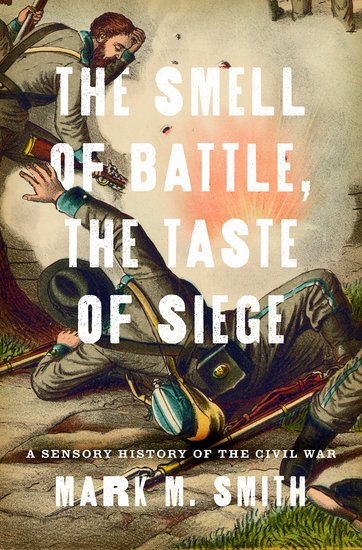
Historical accounts of major events have almost always relied upon what those who were there witnessed. Nowhere is this truer than in the nerve-shattering chaos of warfare, where sight seems to confer objective truth and acts as the basis of reconstruction. In The Smell of Battle, the Taste of Siege, historian Mark M. Smith considers how all five senses, including sight, shaped the experience of the Civil War and thus its memory, exploring its full sensory impact on everyone from the soldiers on the field to the civilians waiting at home.
From the eardrum-shattering barrage of shells announcing the outbreak of war at Fort Sumter; to the stench produced by the corpses lying in the mid-summer sun at Gettysburg; to the siege of Vicksburg, once a center of Southern culinary aesthetics and starved into submission, Smith recreates how Civil War was felt and lived. Relying on first-hand accounts, Smith focuses on specific senses, one for each event, offering a wholly new perspective. At Bull Run, the similarities between the colors of the Union and Confederate uniforms created concern over what later would be called “friendly fire” and helped decide the outcome of the first major battle, simply because no one was quite sure they could believe their eyes. He evokes what it might have felt like to be in the HL Hunley submarine, in which eight men worked cheek by jowl in near-total darkness in a space 48 inches high, 42 inches wide. Often argued to be the first “total war,” the Civil War overwhelmed the senses because of its unprecedented nature and scope, rendering sight less reliable and, Smith shows, forcefully engaging the nonvisual senses. Sherman’s March was little less than a full-blown assault on Southern sense and sensibility, leaving nothing untouched and no one unaffected.
One last thought: the identification (and limitation) of just five senses is a conventional, European construction, and so I’m left wondering about Steve’s final suggestion: that perhaps the intensity of experience in the deserts of North Africa and the Central Highlands of Vietnam reveals the dependence of the Cartesian model on particular ‘natures’ and, above all, on the ethnocentric privileges accorded to ‘temperate nature’ as ‘normal nature’. These radically intemperate natures – the Western Front too – thus took their toll on more than the bodies of the soldiers who fought through them.
I’ll be in Berlin in December for a conversation with James Bridle about drone wars and related issues, and I’m already looking forward to it since I’m a great admirer of his work. I particularly admire the way in which he challenges so many of our assumptions about ‘looking’ through his presentations about militarised vision and violence, and I’ve noted before the filiations between his various projects and Josh Begley‘s.
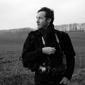
So I was interested to read about photographer Tomas van Houtryve‘s (right) project Blue Sky Days. He begins with an arresting observation with which both James and Josh would be only too familiar:
‘Although a huge amount of [full motion video] footage has been collected [by US drones], the program is classified, and few people have ever seen images of the drone war and its casualties. This seems like a paradox in our thoroughly media-connected age. How can America be involved in a decade-long war where the sky is buzzing with cameras, and yet the public remains totally in the dark?’
But his response to the question is distinctly different: he repatriates the drone wars from Pakistan to the United States (here the most appropriate comparison is with Omar Fast‘s 5,000 Feet is the Best).
To do so, Tomas travelled across America with a small quadcopter drone bought from Amazon.com attached to his camera. His concept was simple, Rena Silvermanexplains in the New York Times:
Take the idea of foreign drone strikes and instead target similar domestic situations, putting them under surveillance using his drone in public spaces. He made a list of hundreds of different strike reports, gleaning as many details about the circumstances…
He rented a black car with tinted windows and placed himself, his drones, his batteries and lists in the car. He spent six weeks in late 2013 averaging between seven and 10 drone flights daily, sleeping in a different town every night. He would pull the car into an empty lot, get out, launch the drone for about five to 10 minutes — about as long as its power lasted — take footage, land the drone, drive away and recharge the batteries while en route to the next location…
He followed his list carefully, trying to imitate “signature strikes,” referring to a May 2012 New York Times article in which some State Department officials complained about the lax criteria for identifying a terrorist “signature.” The joke was that “three guys doing jumping jacks” could be enough suspicious activity for the C.I.A. to conclude it could be a terrorist training camp. In other words, targeting people based on behavior rather than identity.
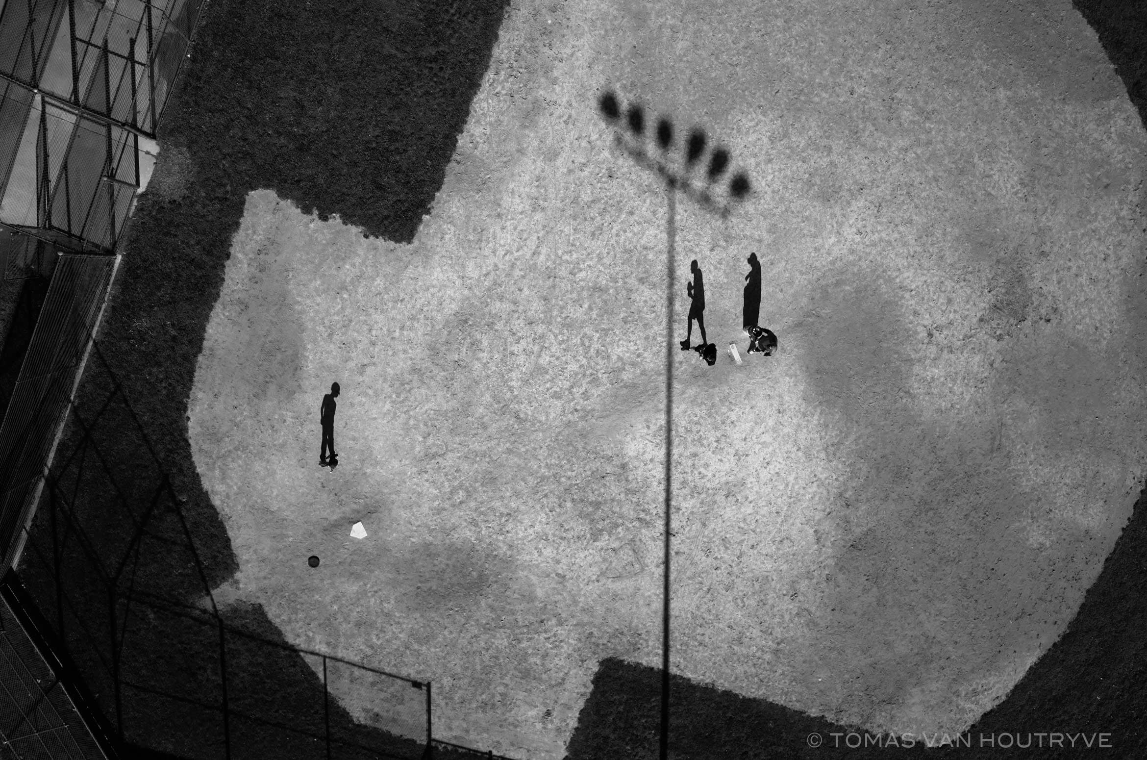
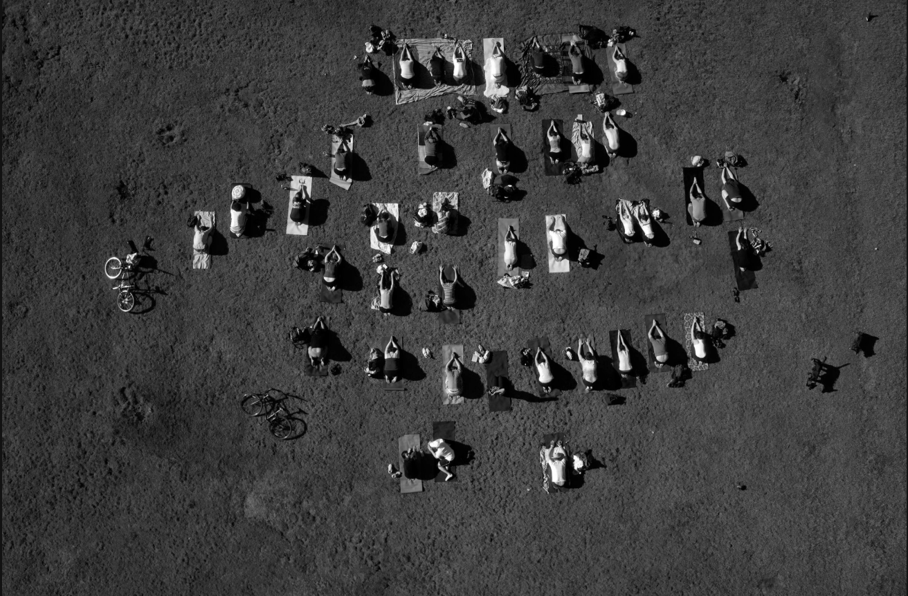
He photographed people exercising in Philadelphia, their shadows long and pinned against the grid of a park. He noticed more “signature” behavior while driving through San Francisco, where he encountered a group doing yoga [above]. When Mr. van Houtryve recently printed the image, he asked viewers if they thought the subjects were praying or exercising. It was a toss-up.
Although these images are not quite ‘what drone attacks in America would look like’, as Pete Brooksuggested in WIRED – Tomas’s drone was flying much lower (‘only about six stories high’) and these images are pin-point sharp: there’s none of the ambiguity of infra-red heat signatures here – none the less that last sentence really says it all. Images do not speak for themselves and interpretation counts for everything – which is why, as I’ve repeatedly argued, it matters so much what pilots, sensor operators and image analysts are pre-disposed to see.
It turns out that a particular incident provoked Tomas’s project – the murder of Mamana Bibi at Ghunda Kala in North Waziristan on 24 October 2012, which I described here – and also gives it its title.
In October 2012, a drone strike in northeast Pakistan killed a 67-year-old woman picking okra outside her house. At a briefing held in 2013 in Washington, DC, the woman’s 13-year-old grandson, Zubair Rehman, spoke to a group of five lawmakers. “I no longer love blue skies,” said Rehman, who was injured by shrapnel in the attack. “In fact, I now prefer gray skies. The drones do not fly when the skies are gray.”
There’s more from Tomas at Harper’s here, which originally co-sponsored the project with the Pulitzer Center, and you can see more of his drone’s eye view images at the National Geographichere.
There’s also a revealing interview conducted by Bard College’s Center for the Study of the Drone here; it contains all sorts of interesting observations, but one in particular resonated. Asked about the tension between the beauty of his photographic compositions and the horror of what he is seeking to convey, Tomas says this:
‘The base subject that I’m trying to raise awareness about and get people to think about in less abstract terms is the foreign drone war. If you take the time to read through the particular airstrikes, a lot of them are quite horrifying. But on the other hand, as a photographer, I know that beauty is one of the tools that we use to get people to look at a picture. Beauty has a lot of power, so there’s a tension between trying to seduce people with the language of photography, which is beautiful composition, and trying to reveal something that might be uncomfortable or difficult to digest, once people fully grasp it.’
Another of my art icons, elin o’Hara slavick, says something very similar about her mesmerising sequence of aerial images of places bombed by the US, Bomb after bomb (see also Brian Howe‘s discussion here and my own in ‘Doors in to Nowhere’ [DOWNLOADS tab], from which I’ve taken this passage):
‘She adopts an aerial view—the position of the bombers—in order to stage and to subvert the power of aerial mastery. The drawings are made beautiful “to seduce the viewer,” she says, to draw them into the deadly embrace of the image only to have their pleasure disrupted when they take a closer look. “Like an Impressionist or Pointillist painting,” slavick explains, “I wish for the viewer to be captured by the colors and lost in the patterns and then to have their optical pleasure interrupted by the very real dots or bombs that make up the painting.”’
A tart reminder that there are multiple ways of ‘just looking‘.
We’ve been here before – ‘wars’ on this and ‘wars’ on that. It’s strange how reluctant states are to admit that their use of military violence (especially when it doesn’t involve ‘boots on the ground‘) isn’t really war at all – ‘overseas contingency operations’ is what the Pentagon once preferred, but I’ve lost count of how many linguistic somersaults they’ve performed since then to camouflage their campaigns – and yet how eager they are to declare everything else a war.
These tricks are double-edged. While advanced militaries and their paymasters go to extraordinary linguistic lengths to mask the effects of their work, medical scientists have been busily appropriating the metaphorical terrain from which modern armies are in embarrassed retreat.
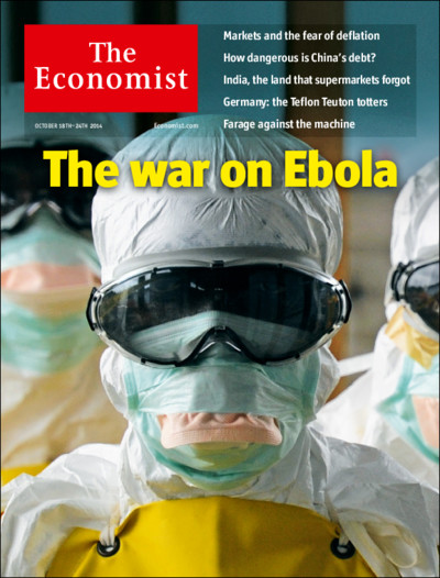
Yet all metaphors take us somewhere before they break down, and the ‘war on Ebola’ takes us more or less directly to the militarisation of the global response. In an otherwise critical commentary, Karen Greenberg draws parallels between the ‘the war on terror’ and the ‘war on Ebola’:
‘The differences between the two “wars” may seem too obvious to belabor, since Ebola is a disease with a medical etiology and scientific remedies, while ISIS is a sentient enemy. Nevertheless, Ebola does seem to mimic some of the characteristics experts long ago assigned to al-Qaeda and its various wannabe and successor outfits. It lurks in the shadows until it strikes. It threatens the safety of civilians across the United States. Its root causes lie in the poverty and squalor of distant countries. Its spread must be stopped at its region of origin — in this case, Guinea, Liberia, and Sierra Leone in West Africa — just as both the Bush and Obama administrations were convinced that the fight against al-Qaeda had to be taken militarily to the backlands of the planet from Pakistan’s tribal borderlands to Yemen’s rural areas.’
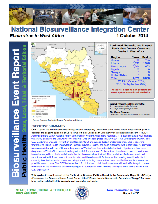
There are other parallels too, not least the endless re-descriptions of terrorism and even insurgency as life-threatening diseases, ‘cancers’ on the body politic. And, as Josh Holmesshows, there is also an entirely parallel (geo)politics of fear in both cases (see also Rebecca Gordon on the racialization of ‘the fear machine’ here). Given the threat supposedly posed by ‘the enemy within’, it’s not surprising that US Northern Command has already set up a 30-person ‘military rapid response team‘ for domestic Ebola cases, and that the Department of Homeland Security has been issuing Biosurveillance Event Reports on the Ebola outbreak in West Africa from the National Biosurveillance Integration Center.
But as I’ve said, Karen’s is a critical commentary and so, before the military metaphors carry us away, her conclusion bears repeating:
The United States is about to be tested by a disease in ways that could dovetail remarkably well with the war on terror. In this context, think of Ebola as the universe’s unfair challenge to everything that war bred in our governmental system. As it happens, those things that the U.S. did, often ineffectively and counterproductively, to thwart its enemies, potential enemies, and even its own citizenry will not be an antidote to this “enemy” either. It, too, may be transnational, originate in fragile states, and affect those who come in contact with it, but it cannot be stopped by the methods of the national security state.
To make sense of all this, I think we need to stand back and start with four general observations:
(1) Modern military medicine has long involved more than evacuating and treating the wounded from the field of battle. It has always had a substantial public health component. Until the early twentieth century, ‘infectious diseases unrelated to trauma were responsible for a much greater proportion of the deaths during war than battle-related injuries‘. As militaries started to pay much closer attention to hygiene and disease prevention, Matthew Smallman-Raynorand Andrew Cliff estimate that the ratio of ‘battle deaths’ to deaths from disease amongst the military population fell from 1:0.4 in the First World War to 1:0.1 in the Second World War; then it rose to 1:0.13 in the Vietnam War but in the first US-led Gulf War (1991) it fell to 1:0.01.
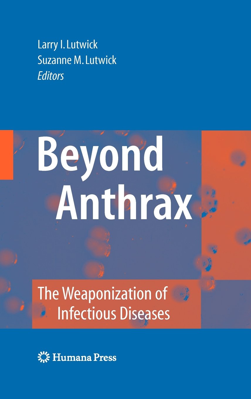
(2) Modern militaries are no strangers to biowarfare either. Both sides in the First World War experimented with chemical weapons, and although the US Army’s explicitly offensive Biological Warfare Weapons Laboratories closed in 1969 the commitment to ‘bio-defense’ and bio-security has ensured a continuing military investment in the weaponisation of infectious diseases (see right). I don’t subscribe to the view that the Ebola epidemic in West Africa is the result of a rogue US biowarfare program – see for example the claims made by ‘Robert Wenzel’here: and if you want to know why his name is in scare-quotes, appropriately enough, read Chris Becker‘s takedown here – nor to the fear that what Scientific Americancalls ‘weaponised Ebola’ is poised to become a ‘bio-terror threat’. But I do think it worth noting the work of the US Army Medical Research Institute of Infectious Diseases which has had field teams on the ground in West Africa since 2006, and the importance placed on surveillance and monitoring.
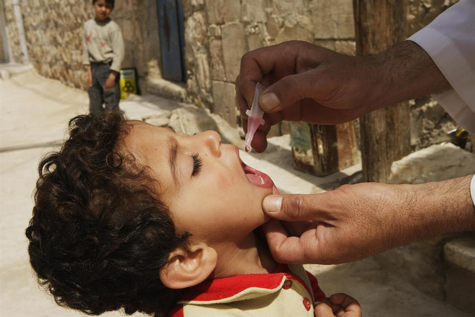
(3) I also think it’s necessary to think through the biopolitics of public health in relation to military and paramilitary violence. This takes multiple forms. It’s become dismally apparent that in many conflict zones hospitals, doctors and other health-care workers have become targets: in Gaza, to be sure, but in Syria and elsewhere too. The treatment of disease has also become a tactical vector: think of the CIA’s use of polio vaccination campaigns as a cover for its intelligence operations and – the conjunction is imperative – the Taliban’s manipulation of polio vaccinations in Pakistan’s Federally Administered Tribal Areas. Think, too, of the way in which the Assad regime has inflicted a resurgent, even counterinsurgent geography of polio on the Syrian people. As Annie Sparrowshows (see also here):
‘This man-made outbreak is a consequence of the way that Syrian President Bashar al-Assad has chosen to fight the war—a war crime of truly epidemic proportions. Even before the uprising, in areas considered politically unsympathetic like Deir Ezzor, the government stopped maintaining sanitation and safe-water services, and began withholding routine immunizations for preventable childhood diseases. Once the war began, the government started ruthless attacks on civilians in opposition-held areas, forcing millions to seek refuge in filthy, crowded, and cold conditions. Compounding the problem are Assad’s ongoing attacks on doctors and the health care system, his besieging of cities, his obstruction of humanitarian aid, and his channeling of vaccines and other relief to pro-regime territory.
‘… nearly all the cases of polio have occurred in areas of northern Syria under rebel control, where the government is seemingly doing everything in its power to prevent vaccination. The Syrian government has appealed to the UN for hundreds of medicines for areas of the country it controls, while largely ignoring the far more dire needs of opposition-held areas. Many children, especially newborns, still do not have access to polio immunization. Daily government airstrikes target the very health facilities that should be the foundation of vaccination efforts, as well as the children who should be protected from polio, measles, and other preventable childhood diseases. As Dr. Ammar, a doctor from Aleppo, said to me bitterly after an April 30 airstrike killed twenty-two schoolgirls, “The government’s polio control strategy for children is to kill them before they can get polio.”’
In her original essay, Sara shows how powerful states in the global North joined forces with the World Health Organisation to construct infectious disease as an existential security threat that demanded new rules and protocols for its effective containment. Crucially:
‘The outcome of this has been the development of international health cooperation mechanisms that place western fears of an outbreak reaching them above the prevention of such outbreaks in the first place. In turn, the desire of the WHO to assert its authority in the project of disease surveillance and containment has led it to develop global health mechanisms that primarily prioritizes the protection of western states from disease contagion.’
This has a genealogy as well as a geography (or what Alan Ingram once called a ‘geopolitics of disease’). Peter Dörrienotes that on 18 September 2014 the U.N. Security Council declared the current Ebola outbreak in West Africa ‘a threat to international peace and security’, and that this was ‘the first time the U.N. had taken this step in a public health crisis‘ (in fact the Council had previously expressed similar concerns about the impact of HIV/AIDS on ‘stability and security’). Under Chapter VII of the UN Charter this declaration has significant legal implications, as Jens David Ohlin notes here, but what most concerns Peter is how long it took for the Security Council to stir itself. It issued its statement 180 days after the WHO confirmed the outbreak, and over a month after the WHO had declared Ebola a ‘Public Health Emergency of International Concern’, and in his eyes the international system ‘ignored the problem until it was too big for any solution other than full-scale military intervention.’ But I’ve already suggested, it’s wrong to treat the militarisation of epidemic disease as somehow new. Of direct relevance to the present ‘war on Ebola’ is this passage from Sara’s essay:
The United States has been a keen participant in disease surveillance and response since the mid-1990s. The United States Department of Defense (US DoD) has had overseas infectious disease research laboratories located in over 20 countries for nearly ten years. The Global Emerging Infectious Surveillance and Response System (DoD-GEIS) mobile laboratories were set up for the purpose of ‘responding to outbreaks of epidemic, endemic and emergent diseases’, and their location in the DoD, as opposed to the United States Agency for International Development (USAID) or Centre for Disease Control (CDC) demonstrates how seriously the United States views the response to infectious disease as a key national security strategy.
So, four observations about the military-medical-security nexus that provide a context for the ‘war on Ebola’. There are two other issues that should also be on the table before proceeding.
The first involves the imaginative geographies circulating in the global North that (mis)inform public response to the epidemic. Many of them can be traced back to colonial descriptions of the coast of nineteenth-century West Africa (and Sierra Leone in particular) as ‘the white man’s grave’, a form of what in a different context Dan Clayton calls a ‘militant tropically’. The contemporary reactivation of these tropes is clearly a serious concern because it corrodes an effective political response. As geographer Kerrie Thornhill writes,
African and diaspora scholars, already accustomed to the ‘thousand tiny paper cuts’ of casual racism, demonstrate how these (metaphorical) cuts escalate into real fatalities. Writers such as Nanjala Nyabola and Lola Okolosie point out the abundance of racist tropes depicting West African societies as inherently unclean, chaotic, uncooperative, ungrateful, and childlike. This racism reinforces a global culture of disregard for black African lives, and the perception that they are a source of social and biological contamination.
You can find much more on this in Cultural Anthropology‘s brilliant Ebola in Perspective series.
The second is the precarious condition of health care systems in West Africa (Ebola in Perspective is good on this too). Brice de la Vigne, the operations director of MSF, reminds us that ‘both Sierra Leone and Liberia were at war ten years ago and all the infrastructure was destroyed. It’s the worst place on earth to have these epidemics.’ Other critics suggest that these uncivil wars were not the only culprits. In their view, it was the neoliberal economic model forced on West Africa by the global North that was primarily responsible for gutting public health systems:
While years of war played a role in weakening public systems, it is the “war against people, driven by international financial institutions” that is largely responsible for decimating the public health care system, eroding wages and conditions for health care workers, and fueling the crisis sweeping West Africa today, says [Emira] Woods. “Over the past six months to a year there have been rolling health care worker strikes in country after country—Nigeria, Sierra Leone, and Liberia,” said Woods. “Nurses and doctors are risking and losing their lives but don’t have protective gear needed to serve patients and save their own lives. They are on the front lines and have not had their voices heard.”
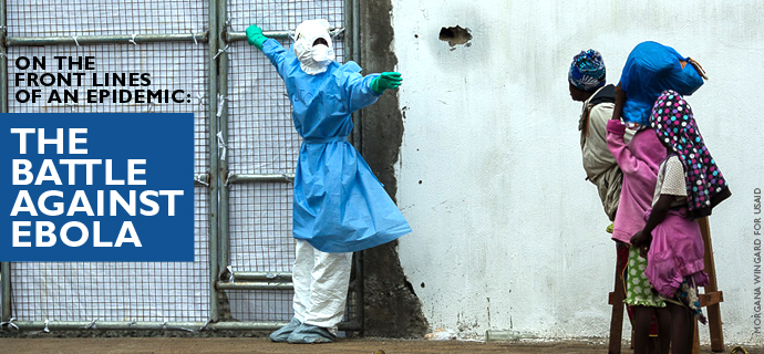
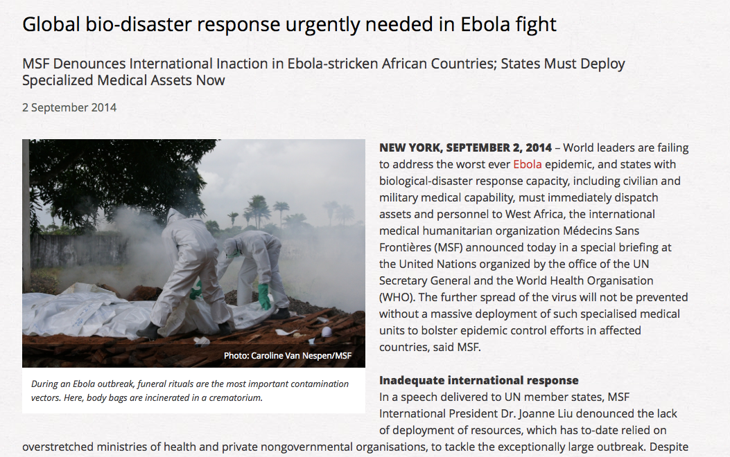
So – back to the front lines. Despite the geopolitical-military-security back story, it was Médecins Sans Frontières that made the first public call (on 2 September) for military assistance in combatting Ebola.
‘States with biological-disaster response capacity, including civilian and military medical capability, must immediately dispatch assets and personnel to West Africa…
‘Many countries possess biological threat response mechanisms. They can deploy trained civilian or military medical teams in a matter of days, in an organised fashion, and with a chain of command to assure high standards of safety and efficiency to support the affected countries…
‘In the immediate term, field hospitals with isolation wards must be scaled up, trained personnel must be dispatched, mobile laboratories must be deployed to improve diagnostics, air bridges must be established to move personnel and material to and within West Africa, and a regional network of field hospitals must be established to treat medical personnel with suspected or actual infections.’
Ten days later Peter Piot, the Director of the London School of Tropical Medicine and Hygiene and the microbiologist who helped identify the Ebola virus in 1976, also called for a ‘quasi-military intervention’. Although he spoke about a ‘state of emergency’, he too wanted to reverse the response prefigured by Giorgio Agamben in such situations and contract the spaces of exception that were multiplying across West Africa. He had in mind ‘beds, ambulances and trucks as well as an army of clinicians, doctors and nurses.’
What materialised was rather different.
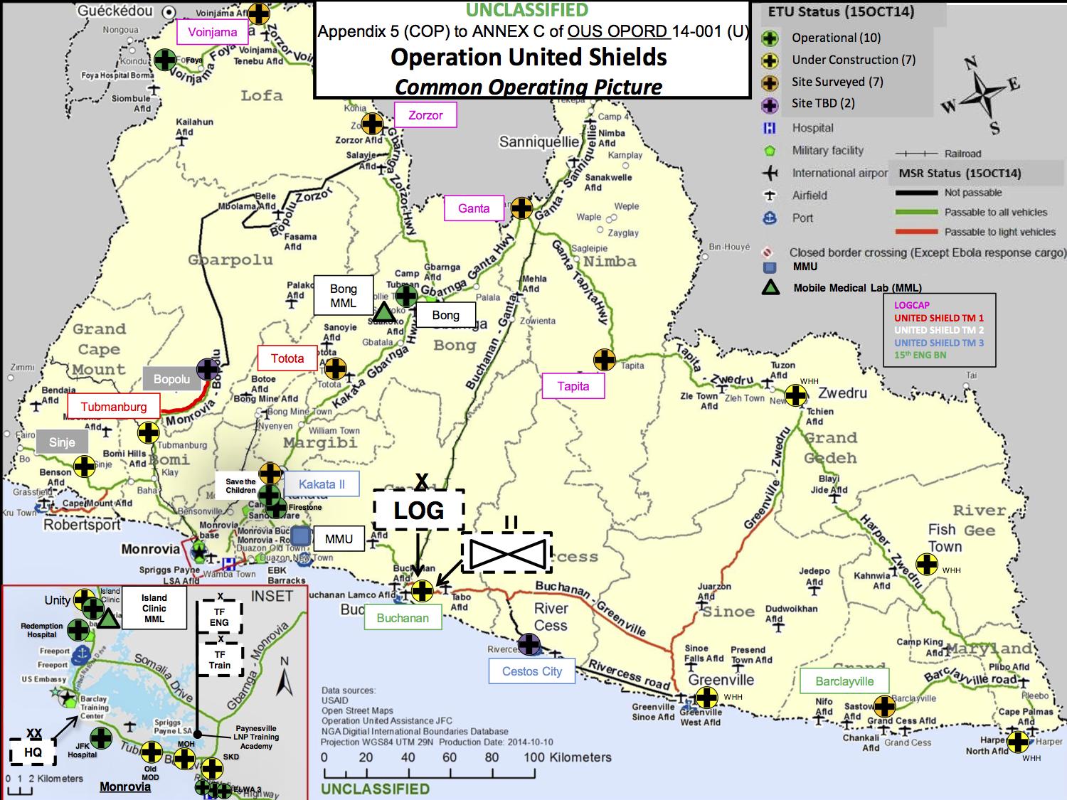
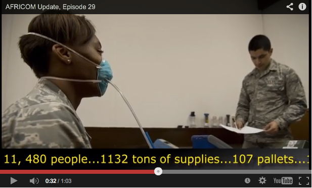
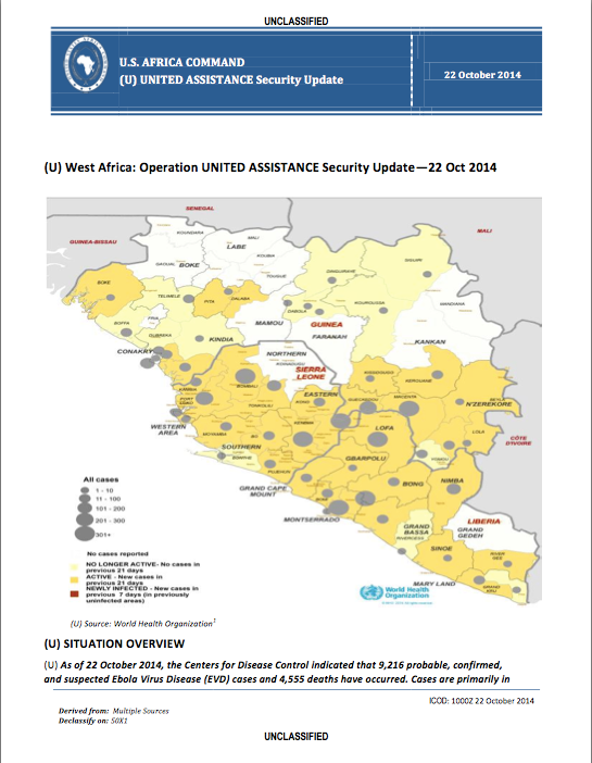
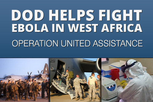
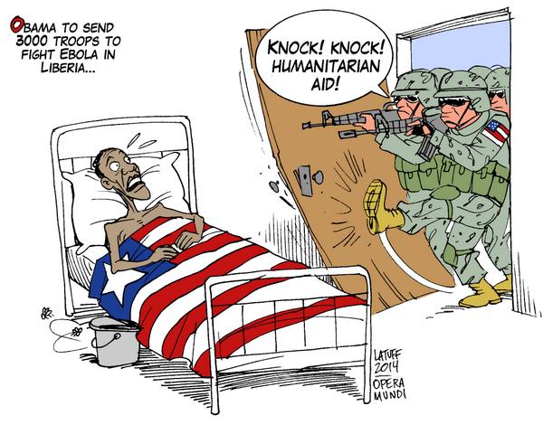
On 16 September President Obama flew to the Centers for Disease Control and Prevention in Atlanta to announceOperation United Assistance. He committed 3-4,000 US troops and $750 million in defence funding to the mission, which is being orchestrated by US Africa Command (AFRICOM) through US Army Africa in concert with USAID. The focus of the US military-medical mission is Liberia. There are close historical connections between the US and Liberia, which originally offered to host AFRICOM’s headquarters in the capital Monrovia; now a Joint Force Command has been set up there. You can find the 75-page AFRICOM operational order here, dated 15 October 2014, from which I’ve taken the ‘common operating picture’ below. The title puzzles me – the only ‘Operation United Shield’ (singular) I’ve been able to find was a multinational operation to evacuate peacekeeping forces from Somalia in 1995. Appendix B is particularly worth reading, incidentally, because it identifies ‘the enemy’: ‘Ebola Virus Disease is the enemy, aided by poor preventive medicine practices in areas where EVD cases are prevalent and difficulties in identifying and treating EVD patients.’
The US deployment is complemented by the deployment of UK forces to Sierra Leone (Operation Gritrock)and French forces to Guinea. In both cases there are also close, colonial connections, and the British-led International Military Advisory Training Team Sierra Leone has been on the ground since 2000 (since last year this has been re-tasked as the International Security Advisory Team Sierra Leone).
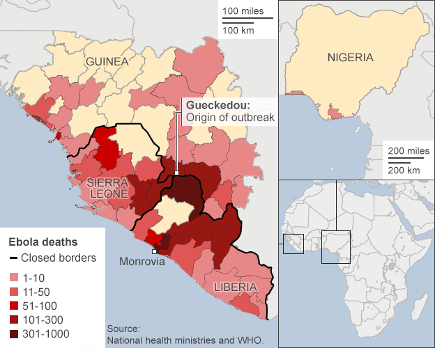
(The map above is borrowed from the BBC; in addition, the Guardian has an interactive map tracing the historical geography of Ebola from the first known case in the Democratic Republic of Congo in 1976 to the present epidemic in West Africa here).
These forces differ in more than geographical deployment; their capabilities differ significantly too. The UK is sending 750 troops, including contingents from the Royal Army Medical Corps (notably 22 Field Hospital), who will construct treatment centres (the aim is to add 700 beds to triple Sierra Leone’s existing capacity) and treat doctors and other health-care workers who contract the disease; they are supported by the Royal Navy’s ‘Primary Casualty Receiving Ship’ RFA Argus (which will provide a further 100 beds), and by another 780 volunteer health care staff.
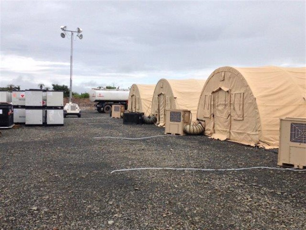
The US has mobilised troops from the 101st Airborne, whose primary mission is to set up 17 Ebola Treatment Units (each with 100 beds); meanwhile the US Air Force’s 633rd Medical Group is establishing a 25-bed Expeditionary Medical Support System field hospital for doctors and other health care workers who contract the disease (below). The US Army has also fielded three mobile laboratories to test samples for the virus, reducing the time to diagnosis from days to hours. According to Pardis Sabeti, who leads viral-genome research at the Broad Institute of M.I.T. and Harvard, ‘the faster you can get a diagnosis of Ebola, the faster you can stop it.’
‘Our enemy is a disease’, declared Lt Col Brian De Santis, echoing AFRICOM’s operational order – but it was quickly made clear that the vast majority of troops will not come into contact with the enemy or any of its victims at all. This is just as well; most of the soldiers have minimal medical training – just four hours from the US Army Medical Research Institute of Infectious Disease – and the Pentagon’s Press Secretary Rear Admiral John Kirbyexplained that there is ‘no intention right now that [troops] will interact with patients or be in areas where they would necessarily come into contact with patients’:
‘They’re not doctors. They’re not nurses. They’re not trained for that and not equipped for that. That’s not part of the mission. They will be kept in locations where they can do their jobs without coming into contact with patients.’
‘It’s like the city that spends all its money to raise up a formidable police force only to discover that what it really needs is a bigger sewage treatment plant. Of course, you can always put cops to work burning human excrement but there are better — that is, more effective and cheaper — ways to solve the problem.’
In effect, this is another case of the military preferring remote operations. Here is a telling passage from Sophie Arie’s interview with MSF’s president Joanne Liu:
‘“Countries are approaching this with the mindset of going to war,” she says. “Zero risk. Zero casualties.” Liu describes the current military efforts as the equivalent, in public health terms, of airstrikes without boots on the ground. Pledges of equipment and logistical support are helpful—“The military are the only body that can be deployed in the numbers needed now and that can organise things fast.” But there is still a massive shortage of qualified and trained medical staff on the ground. “You need to send people not stuff and get hands on, not try to do this remotely,” Liu says…’
The primary areas for military operations in the ‘war on Ebola’ to date are surveillance, logistics and containment. I’ll consider each in turn.
Last week Public Intelligencereleased a series of weekly Security Updates and daily Intelligence Summaries produced by AFRICOM to support Operation United Assistance. These rely largely on WHO reporting to track the spread of the disease.
This is to work at a highly aggregate level. Most public health experts suggest that the key to stopping the spread of the disease is contact tracing – which, in its essentials, is the same methodology used by the military and the intelligence services to track individuals through terrorist and insurgent networks – and has been used successfully in both the United States and in Nigeria (which was declared free of Ebola on 20 October). Ezra Kleindescribes it as ‘almost ludicrously simple’ and ‘as low-tech as medicine gets’, and so it is in principle.
But its application in much of West Africa is immensely difficult: the UN estimates that only 16 out of 44 zones have adequate procedures and personnel in place. And since many local people are understandably fearful of the consequences of their answers, it is unlikely that military involvement would improve the situation. Here is Elizabeth Cohen and John Bonifield:
‘People are often uncooperative with the tracers, sometimes even throwing stones at health care workers. They fear that they or their loved ones will be put in the hospital; they’ve seen firsthand that people who go there often don’t return.
“The community perceives this as a death sentence,” [Donald Thea, an infectious disease epidemiologist] said. “Relinquishing your loved one is tantamount to death.”
And health care workers have very little to offer people as an incentive to cooperate. “With smallpox, we could offer people a vaccine, a carrot in essence to induce them to be cooperative. With Ebola, we have nothing,” Thea said.’
Logistics is the area where the military comes into its own. MSF had emphasised that its priorities included ‘the mass expansion of isolation centers, air bridges to move personnel and equipment to and within the most affected countries, mobile laboratories for testing and diagnosis, and building a regional network of field hospitals to treat suspected or infected medical personnel.’ Much of the military effort is currently concentrated in these areas, but the other side to mobilising medical personnel, equipment and testing and treatment facilities is, in effect, immobilising the population.
Containment runs the gamut from quarantine through curfews and lockdowns to border closures. Most observers believe that border closures would be counter-productive: if you want to know why, see Debora MacKenzie‘s short essay here. The other, seemingly lesser measures also have their dangers. In its original call for assistance, MSF insisted that ‘any military assets and personnel deployed to the region should not be used for quarantine, containment, or crowd control measures’, and it emphasised that ‘forced quarantines have only bred fear and unrest, rather than stem the virus.’
But others have other ideas. Major Matt Cavanaugh, from the US Army War College, has made an unofficial, back-of-the-envelope calculation of what a successful ‘containment strategy’ for Ebola would require. He is adamant that only ‘boots on the ground’ could do the job, though the nature of that ‘job’ remains elusive in his account. He talks about military logistics – the ability to ‘fix “the last mile” problem’ – but he also notes the need ‘to fill the basic state functions related to health, security, and public order in order to adequately respond to the threat.’ In case that triptych isn’t clear enough, in his subsequent ‘Ebola Manifesto‘ the major declares that ‘There is exactly one organization designed to rapidly hold and control territory and the people on it: the military.’ The figure he eventually arrives at – somewhere between 36,600 to 73,200 troops – is derived from the wars in Afghanistan and Iraq, and suggests that, for some commentators at least, the Ebola crisis is an opportunity to deepen AFRICOM’s investment in what Jan Bachmann calls ‘policing Africa’ [see his ‘Policing Africa: the US military and visions of crafting “good order”‘, Security Dialogue 45 (2) (2014) 119-36]:
‘The spectrum of [AFRICOM’s] activities can be understood most comprehensively through an analytical perspective of policing, in which the aim of establishing ‘good order’ through an expansive regulatory engagement in issues of welfare is applied to contexts of ‘fragile’ statehood and ‘ungoverned spaces’.’
This is not a uniquely American view. The Daily Mail (where else?) reports that one of the options being considered by Britain’s Chief of the General Staff is a full-scale military lockdown of Sierra Leone:
‘From a military perspective ebola is like a biological warfare attack and should be countered accordingly. There needs to be a clampdown on human movement inside Sierra Leone and possibly to and from the country between now and late 2015 when it is hoped that an antidote will have been developed.’
It’s hard to know how much credence this should be given, of course, though the very existence of proposals like these suggests that the ‘soft power’ which Joeva Rock sees in the militarisation of Ebola conceals an iron fist. And Niles Williamsonbelieves that the military-medical missions are a smokescreen:
‘The main purpose of this military operation is not to halt the spread of Ebola or restore health to those that have been infected. Rather the United States is seeking to exploit the crisis to establish a firm footing on the African continent for AFRICOM.’
That may be one of the objectives, but I think it’s a bridge too far to claim it as the main purpose: as I’ve tried to show, the militarisation and securitisation of Ebola has many other geopolitical and biopolitical dimensions. And Nick Turse has revealed that AFRICOM, far from having a ‘light footprint’, has already achieved a remarkably rapid tempo of operations across the whole continent.
Still, even in its less extreme versions, the ‘war on Ebola’ clearly raises urgent questions about the militarisation of humanitarian aid, about what Kristin Bergtora Sandvikcalls a ‘crisis of humanitarian governance’, and about the violence that is involved in the production of the humanitarian present.
I’m in Zurich – many thanks to Benedikt Korf for the invitation and the wonderful hospitality – for a seminar with Benedikt’s doctoral students on the long form version of ‘The Natures of War’(they have what I hope is the penultimate draft; I’ll post the final version once I’ve reworked it after the seminar) and then a public lecture: ‘Angry eyes: the militarization of vision and modern war’.
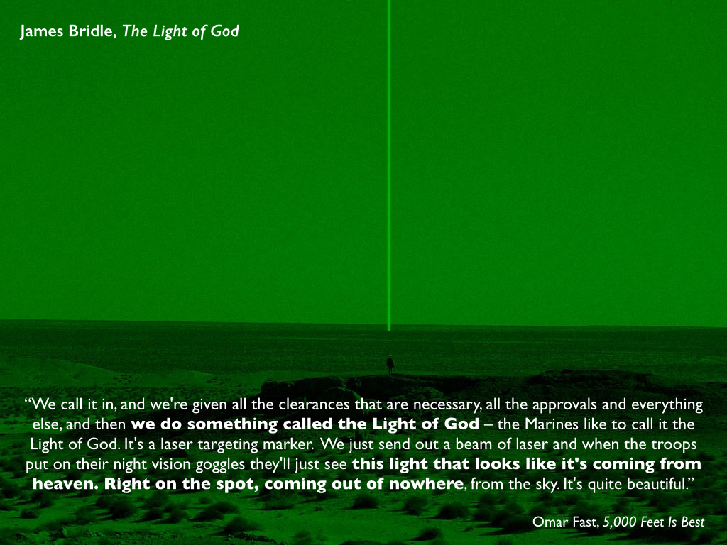
Part of my argument in the lecture is about the narrowness of ‘Predator View’, so let me explain what I mean. My starting point is the illusion that the use of the intelligence, surveillance and reconnaissance capabilities of remote platforms like the MQ-1 Predator or the MQ-9 Reaper produces a transparent battlespace: in effect, a version of Donna Haraway‘s ‘God-trick’, the ability to see everything from nowhere in particular. The most succinct version of this is the treatment of laser targeting as ‘the eye of God’:
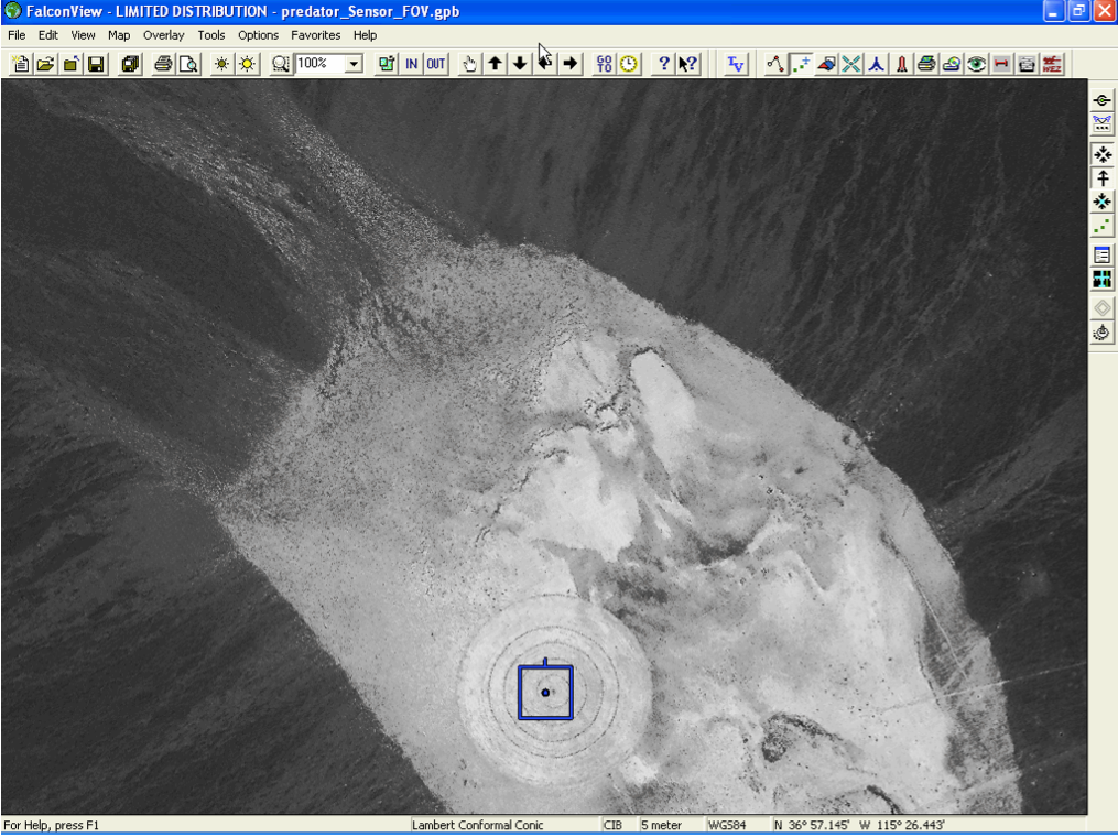
In fact, ‘Predator View’ is remarkably narrow. First, and most directly, a common complaint is that the view provided by its Full Motion Video is literally too narrow – ‘like looking through a soda straw’. It’s for this reason that pilots and sensor operators also use FalconView, a Windows-based mapping tool that is supposed to provide them with situational awareness. I’ve taken the image below from a presentation by Lt Col Paul Hastert (USAF) on ‘Spiral development in wartime’ – the screenshot is the FalconView image, the small square the field of view from a Predator – but the most detailed account of FalconView is Jon Lindsay‘s ‘”War upon the map”‘: User innovation in American military software’, Technology and culture 51 (3) (2010) 619-51.
There have been several later releases of FalconView, and a version is now even open source, so it’s probably not surprising that the US military also uses Google Earth. In fact, in two of the air strikes I consider in detail it was, in part, juggling these different views that contributed to wrong targeting decisions. (There are projects that provide a wider field of view – the nine-camera suite of Gorgon Stare is in operation and its second increment is already in use in Afghanistan – and others that integrate imagery from multiple sources, like Raytheon’s Zeus, which is intended to supplant FalconView as the ‘primary mission execution tool‘).
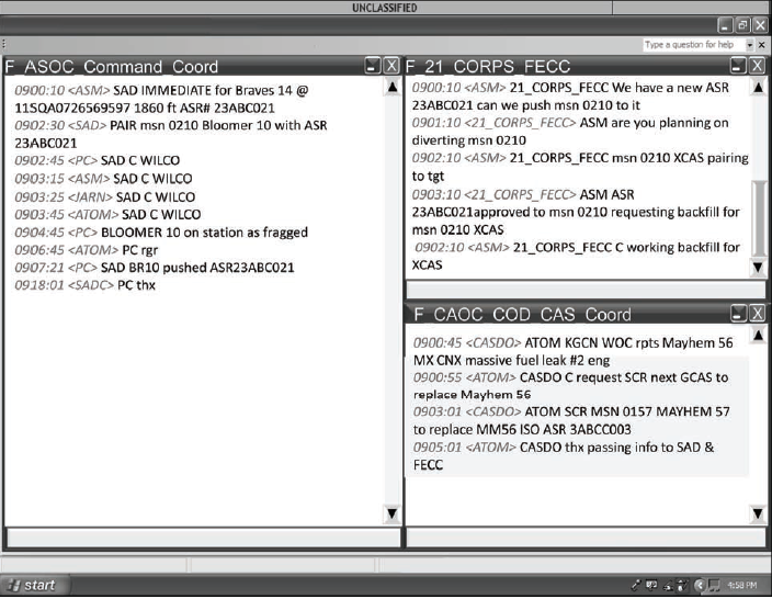
But in the air strikes that I consider those involved in these networked operations are also busy communicating via radio and – crucially – via the typed messages displayed in mIRC‘s online chat windows. The image below is taken from the US military’s multi-service manual on Tactical Chat (see also the discussion at Public Intelligence here).
In the case of the ‘friendly fire’ incident in the Sangin Valley in 2011, the pilot and sensor operator were unaware of crucial entries made by image analysts in mIRC and of private (or ‘whisper’) chats to the Mission Intelligence Co-ordiator. That’s not entirely surprising. Once permission has been given to engage a target, ‘KILL CHAIN” is typed into the room to minimise extraneous chatter that might otherwise visually distract and so ‘degrade’ the strike. According to the Mission Intelligence Controller for the Sangin incident:
‘When we got a standby for a 9-line [strike briefing] we put [KILLCHAIN] in the mIRC room to shut down chatter so we can be heads down supporting the pilot and the sensor … as they are getting ready for a possible Hellfire shot our whatever action… That’s our job, to be their third set of eyes…’
That third set of eyes is vital, though of little use if its responses are shut down. In this case the pilot was paying no attention to mIRC because he was fully occupied:
‘I did not see the chat in the main mission room after seeing muzzle flashes. From that point on, my focus was clear concise communications with the [Joint Terminal Attack Controller] and ensuing [Close Air Support] comms, 9 line etc. At this point I was also focused on keeping the aircraft in position to maintain FMV on the individuals. I was also getting the aircraft into the [Weapons Engagement Zone]. Winds were 30 knots out of the west so I had to make sure I kept the aircraft position and direction in cross check.’
All of this suggests that it is unduly narrow to focus the analytical gaze on the Full Motion Video feeds.
But there’s more. Militarised vision is not limited to Predators and their successors, and it’s important to consider the clarity and resolution of the imagery captured and transmitted from other, conventional aircraft like the AC-130 (first image below), the B-1 bomber, F-15E strike aircraft or attack helicopters (second image below) – again, this was important in two of the strikes I consider in detail.
This leads me to two other senses in which the critical emphasis on ‘Predator View’ is too narrow. It’s a mistake to fasten on one incident – even what has become the iconic ‘signature strike’ coordinated by a Predator on three civilian trucks in Uruzgan – because that misses the continuities, repetitions and transformations in Close Air Support (which is where most of the mistakes are made).
Better, I think, to widen the analytical gaze, which is why I examine the Kunduz air strike on 4 September 2009 (in which no remote platform was involved), the Uruzgan air strike of 21 February 2010 (which was co-ordinated by a Predator but carried out by two attack helicopters), and the Sangin Valley air strike of 6 April 2011 (which was executed by a Predator). The Granai strike is included because it trigged McChrystal’s Tactical Directive of 6 July 2009 to minimise civilian casualties: ‘‘We must avoid the trap of winning tactical victories – but suffering strategic defeats – by causing civilian casualties or excessive damage and thus alienating the people.’ In all three cases I’ve worked through thousands of pages of official investigations – one by the German Bundestag since the ISAF report remains classified (Kunduz), and the others by the US Army and US Air Force (Uruzgan) and the US Marine Corps (Sangin Valley).
And finally, it is also necessary to consider the multiple viewing positions involved in networked military violence. There is a de-centralised, distributed and dispersed geography of militarised vision whose fields of view expand, contract and even close at different locations engaged in the administration of military violence. And in all three incidents it turns out that vital mistakes in the interpretation of imagery were made at operations centres in theatre on the ground.
This has prompted me to radically revise the argument I originally set out in ‘From a view to a kill’ (DOWNLOADS tab). There my focus was on the geography shown in the first map below – like every other commentator I’ve read, incidentally – but I’ve now widened the angle to take in the geography shown in the second map and this substantially changes the story.
It was what happened at the operations centres at Special Operations Task Force 12 in Kandahar and Combined Joint Special Operations Task Force in Bagram that turned out to be every bit as important as the Predator crew’s obvious desire to ‘go kinetic’.
I make similar arguments about Kunduz, where the F-15E pilots were clearly reluctant to strike and the ground commander and JTAC at the Forward Operating Base overrode their objections.
Sangin is even more instructive, because the official investigation of this ‘friendly fire’ incident that resulted in the deaths of two Marines largely exonerated both the Predator crew and the ground commander and JTAC at the operations centre – but a detailed, spirited counter-memorandum from the US Marines commandant refuted the findings line by line, castigated the attempt to pin the blame for what happened on the young, inexperienced lieutenant leading the patrol, and excoriated the ground commander and JTAC back at the patrol base. More on this soon.
The (long!) essay on these strikes is the last chapter I need to complete for The everywhere war. There is a strong sense, so I shall argue, in which it was the view ‘on the ground’ that mattered much more than any ‘light of God’ from above. And as for transparency….
It’s strange how things sometimes come together – or collide and crash. Two weeks ago I wrote about satellite imagery and ‘remote violence’, and over the summer I discussed several projects that mapped Israel’s military assault on Gaza and its people, including the Gaza Crisis Atlas produced by the UN’s Office for the Coordination of Humanitarian Affairs (which makes extensive use of hi-res satellite imagery).
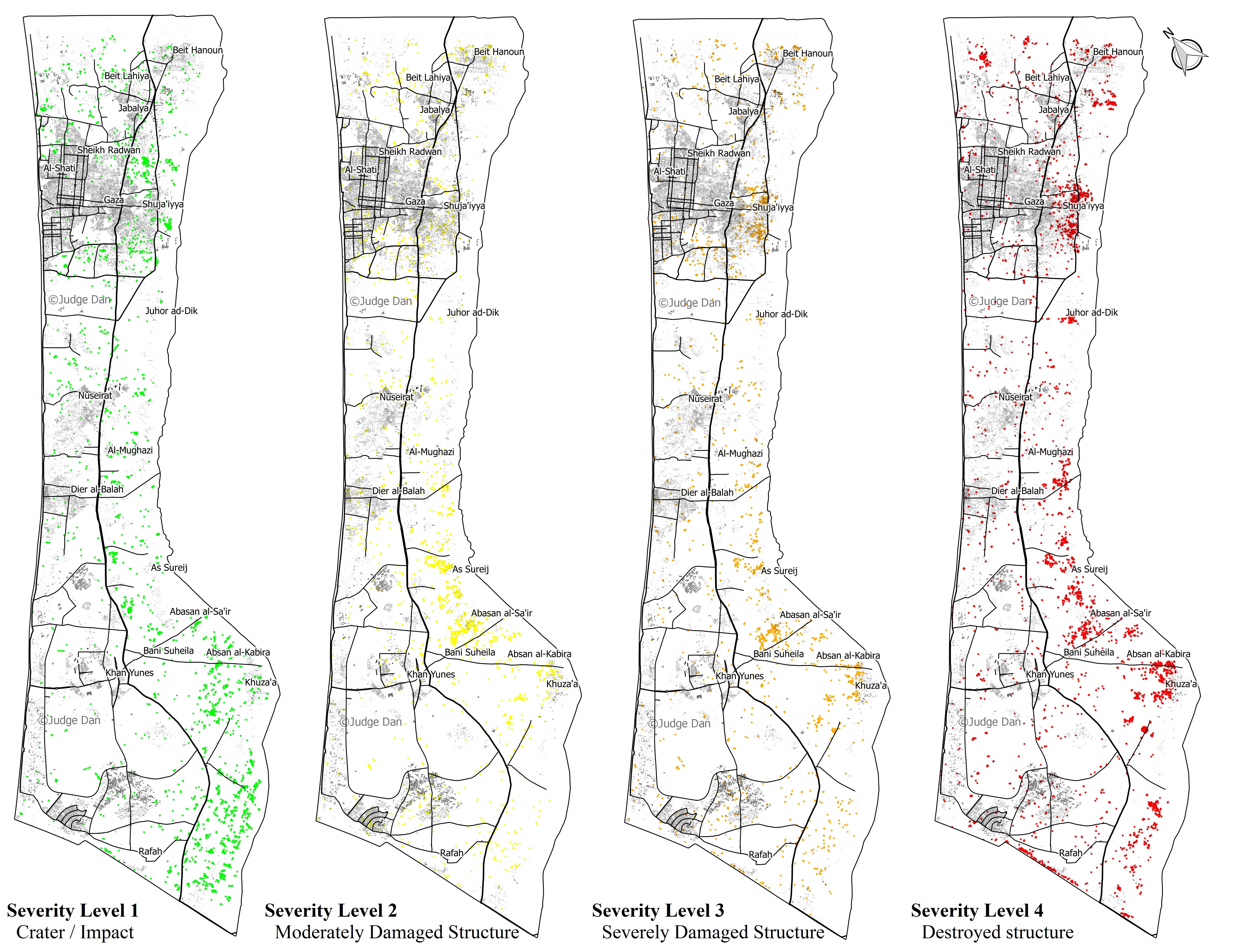
The links between those two posts are obvious enough, but today I have something altogether different in my sights. ‘Judge Dan’ (Dan Smith), who blogs for Israellycool, has used the Gaza Crisis Atlas to construct a series of maps to geo-wash Israel’s military campaign.
Working from the data in the Atlas, Smith produces four maps to disaggregate the severity of destruction (the four levels, increasing from left to right, are based on OCHA’s own assessment):
His conclusions from this exercise are the following:
The attacks are in no way “random” or “indiscriminate”. One can clearly see the spatial distribution of the damage in several aspects. We find 8,952 of the 12,433 total points (72%) are within a 3 KM buffer abutting the border with Israel. The main objective of Operation Protective Edge was to find and destroy dozens of terror tunnels dug from Gaza into Israel.
That the most intensive damage was caused to the area where the tunnels naturally originated is thus perfectly understandable. Furthermore, of the 4,441 destroyed structures, 3,481 of them (78%) are within the 3 KM buffer, as are 2,531 of 3,303 (77%) of the lowest intensity damage (simple craters), which are mostly strikes on rocket launchers and tunnels.
Most of the attacks are grouped around certain neighborhoods or villages, such as Shuja’iyya, Johur ad-Dik, Sureij, and Khuza’a. These were probably the result of the ground operations that took place in dense urban areas also within the 3 KM buffer that housed multiple tunnel entrances and shafts, as well as launch sites for mortars and rockets.
Smith then takes the Israeli military’s map of ‘terrorist infrastructure’ in Shuja’iya and overlays this on what he calls ‘OCHA’s damage points’: ‘the correlation is uncanny.’
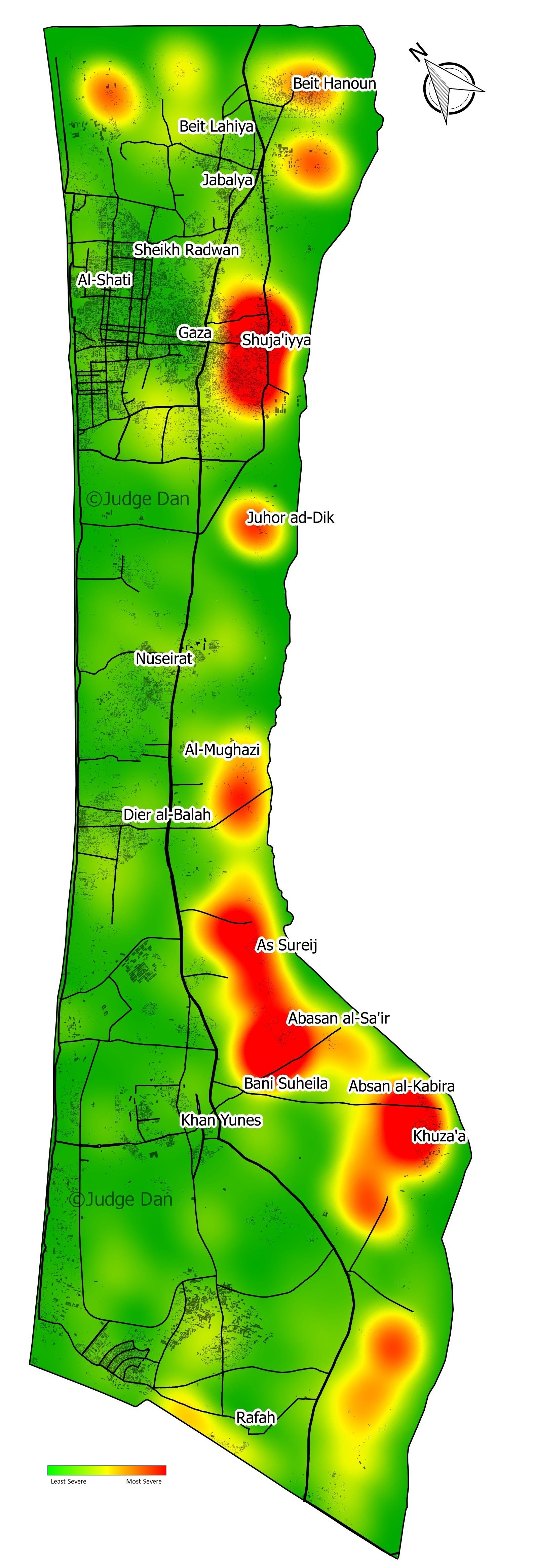
Smith’s next manoeuvre is to sweep aside OCHA’s focus ‘on the civilian aspect’ because it ‘misses the big picture’ (really – or perhaps Israelly): ‘the overall intensity of the strikes’. So he constructs a kernel density map or a ‘damage intensity heat map’:
It now becomes very clear that most of the damage was caused to 5 locations right on the border with Israel. The rest of the Gaza Strip was, for the most part, undamaged. The main population areas of Gaza city, Jabaliya, Khan Yunes, Rafah and Deir el-Balah were disproportionately undamaged (sic).
He continues:
If we do a rough estimate of the damage area, it is once again clear the vast majority of the Gaza Strip was unscathed. With a fairly generous estimation that a damage point has a 25 meter radius – the footprint of a house, or the blast radius of a bomb – the total damage area of the 12,433 impacts was in the order of 15 KM2. The land area of the Gaza strip is 360 Km2. In other words, less than 5% of the land was affected.
There’s a follow-up post on ‘damage clusters’ here, but in this commentary I’ll focus on Smith’s ‘big picture’. I take the basic points to be these:
(1) Smith’s approach makes an appeal to the supposed objectivity and even facticity of the map (and, by extension, the satellite image), but there is a substantial body of scholarship that goes back 25 years and underscores the multiple ways in which mapping is an exercise in the production of power. For a depressingly relevant example of the ways in which maps can speak power to truth, taken from Israel’s attack on Gaza in November 2012, see my discussion here (scroll down to the maps).
(2) Appealing to the map and its manipulations as the single source of authority is designed to disavow the testimony of witnesses on the ground: precisely the point sharpened by Andrew Herscherin his timely critique of ‘Surveillant witnessing’ (see my discussion here) and a far cry from the incorporation of photographs in (say) the Gaza War Map.
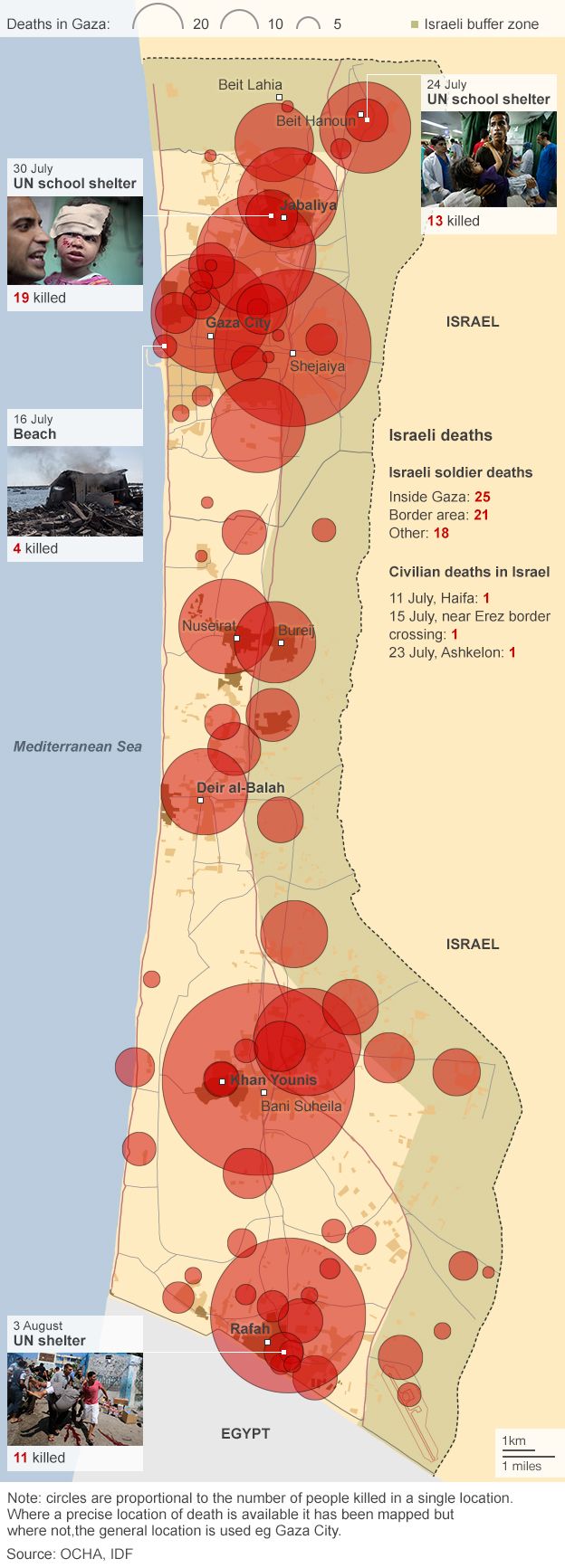
(3) Smith’s methodology reduces Gaza to an object space of structures and buildings, craters and points; he constructs a kernel density map (more on this in a moment) but provides no population density map that would at least gesture towards the people killed, wounded and traumatised by the Israeli offensive and who are wholly absent from his account. Here, by contrast, is a map I posted previously showing deaths in Gaza to 6 August:
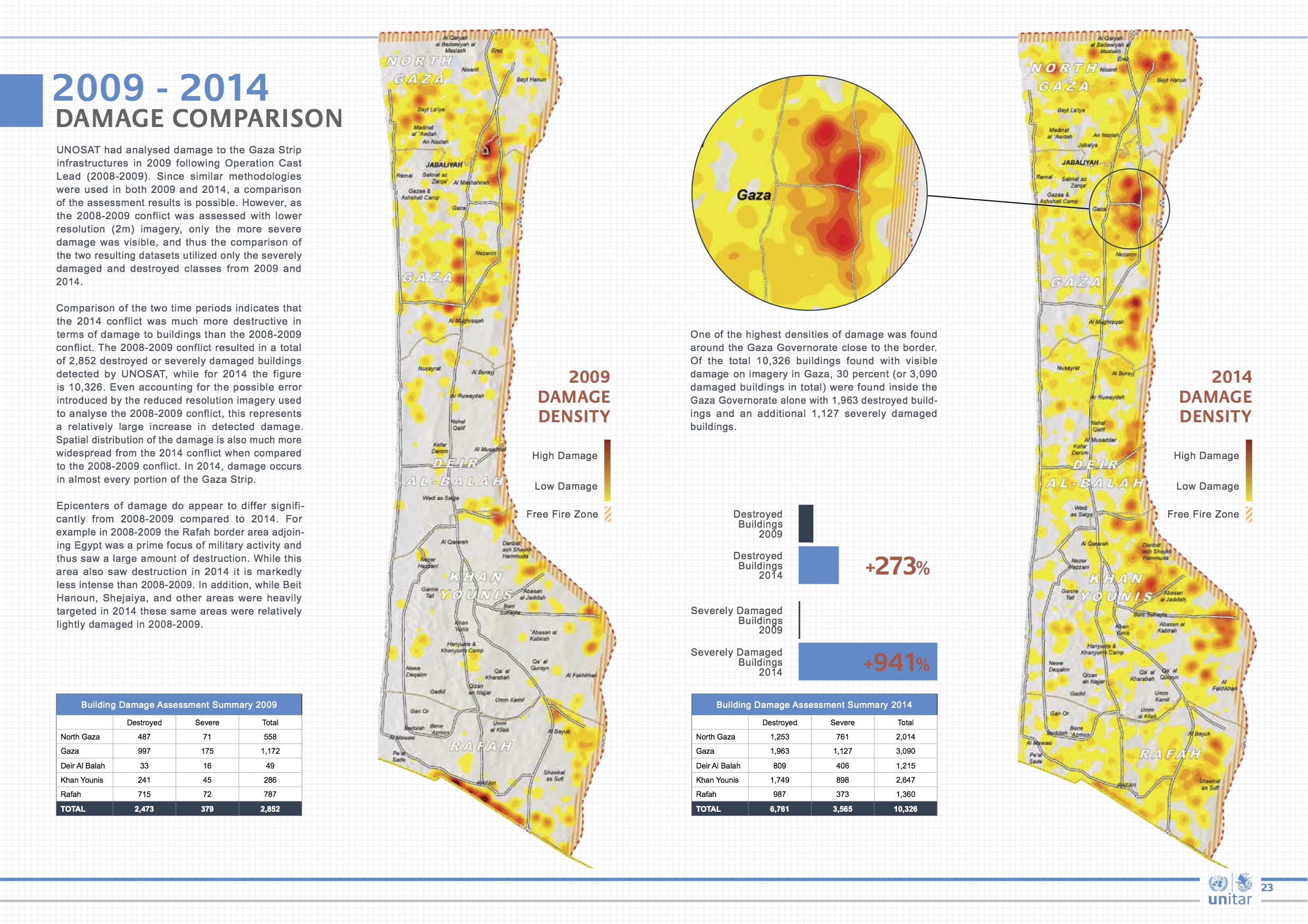
The Gaza Crisis Atlas focuses on damage to buildings and infrastructure because it is a tool directed explicitly towards reconstruction, so the same criticism doesn’t apply (particularly if you look at OCHA’s work more generally, including the information it provided for the map I’ve just reproduced). But if we are to limit ourselves to gazing on structures from space, UNOSAT’s analysis of satellite imagery provides a sharp reminder that these buildings included schools and hospitals (see also here and here); the report also provides a telling comparison between the intensity of destruction in 2009 and 2014:
(4) Smith prefers to construct his own generalised map of damage density using kernel density estimation, a smoothing algorithm that converts point data into a continuous surface. I discussed the way in which the US military uses this technique in ‘Seeing Red’ (DOWNLOADS tab), and what I said there bears repeating:
The maps are known for their dramatic visual impact, and the desired message can be engineered into the production process. One of the most influential handbooks on KDE is published by the US National Institute of Justice and describes how to map crime ‘hot spots’… The authors of the NIJ handbook acknowledge that ‘map production is an iterative process’ and that ‘the first map produced is very rarely the one presented to the target audience.’ They continue: ‘The intended message should also be seen as the driving force behind what the map should look like’ (US National Institute of Justice, 2005: 26, 33).
So let’s turn to the rest of Smith’s message.
(4) Smith justifies the pattern of destruction shown on his maps by claiming that ‘the main objective of Operation Protective Edge was to find and destroy dozens of terror tunnels dug from Gaza into Israel.’ In fact, the stated objectives of the Israeli assault changed throughout the campaign. The attacks were supposedly sparked by the kidnapping and murder of three Israeli teenagers – in the West Bank not Gaza – and as the mission was ratcheted up so their central objective changed: according to the IDF the aim was to put an end to Hamas rockets being fired into Israel (for a radically different view, see Graham Liddell‘s more general discussion at Mondoweisshere). The rhetoric of ‘terror tunnels’ came later. And while Smith is right to draw attention to the swathes of destruction to the east of Gaza’s central spine, he never addresses the human consequences of successive Israeli expansions of this so-called ‘buffer zone’ until it covered more than 40 per cent of Gaza: see my post here for more details.
(5) Towards the end of his analysis, Smith concedes that destruction is not punctiform. Bombs are not ‘pinpoints’ (cf. Nathan Guttman‘s report on Smith’s work and ‘the pinpoint accuracy of Israel’s strikes’), not only because they rarely land exactly on target but also because their blast radiates outwards from the point of impact. But Smith’s ‘fairly generous estimate that a damage point has a 25 meter [82 feet] radius‘ – is in fact a serious underestimate that at the very least halves the blast radius of a 155 mm shell. Here is Mark Perry‘s report that I cited previously, which includes testimony from senior US military officers about the shelling of Shuj’aiyya:
Artillery pieces used during the operation included a mix of Soltam M71 guns and U.S.-manufactured Paladin M109s (a 155-mm howitzer), each of which can fire three shells per minute. “The only possible reason for doing that is to kill a lot of people in as short a period of time as possible,” said the senior U.S. military officer. “It’s not mowing the lawn,” he added, referring to a popular IDF term for periodic military operations against Hamas in Gaza. “It’s removing the topsoil.”
“Holy bejeezus,” exclaimed retired Lt. Gen. Robert Gard when told the numbers of artillery pieces and rounds fired during the July 21 action. “That rate of fire over that period of time is astonishing. If the figures are even half right, Israel’s response was absolutely disproportionate.” A West Point graduate who is a veteran of two wars and is the chairman of the Center for Arms Control and Non-Proliferation in Washington, D.C., he added that even if Israeli artillery units fired guided munitions, it would have made little difference.
Even the most sophisticated munitions have a circular area of probability, Gard explained, with a certain percentage of shells landing dozens or even hundreds of feet from intended targets. Highly trained artillery commanders know this and compensate for their misses by firing more shells. So if even 10 percent of the shells fired at combatants in Shujaiya landed close to but did not hit their targets — a higher than average rate of accuracy — that would have meant at least 700 lethal shells landing among the civilian population of Shujaiya during the night of July 20 into June 21. And the kill radius of even the most precisely targeted 155-mm shell is 164 feet. Put another way, as Gard said, “precision weapons aren’t all that precise.”
(6) Finally, let’s take Smith’s central claim that ‘less than 5% of the land [of Gaza] was affected’ – and reverse it. If Hamas were to say that less than 0.00005% of Israel had been hit by its rockets – to be fair, it’s a difficult calculation to make because Israel has never fixed its borders and so it’s not possible to determine its area – and that the rest of Israel was ‘disproportionately undamaged’, would Israelis have simply shrugged them off?
 Next month Cambridge University Press is publishing a book of essays edited by Peter Bergen and Daniel Rothenberg, Drone wars: transforming conflict, law and policy, due out from Cambridge University Press at the end of the year. Here’s the blurb:
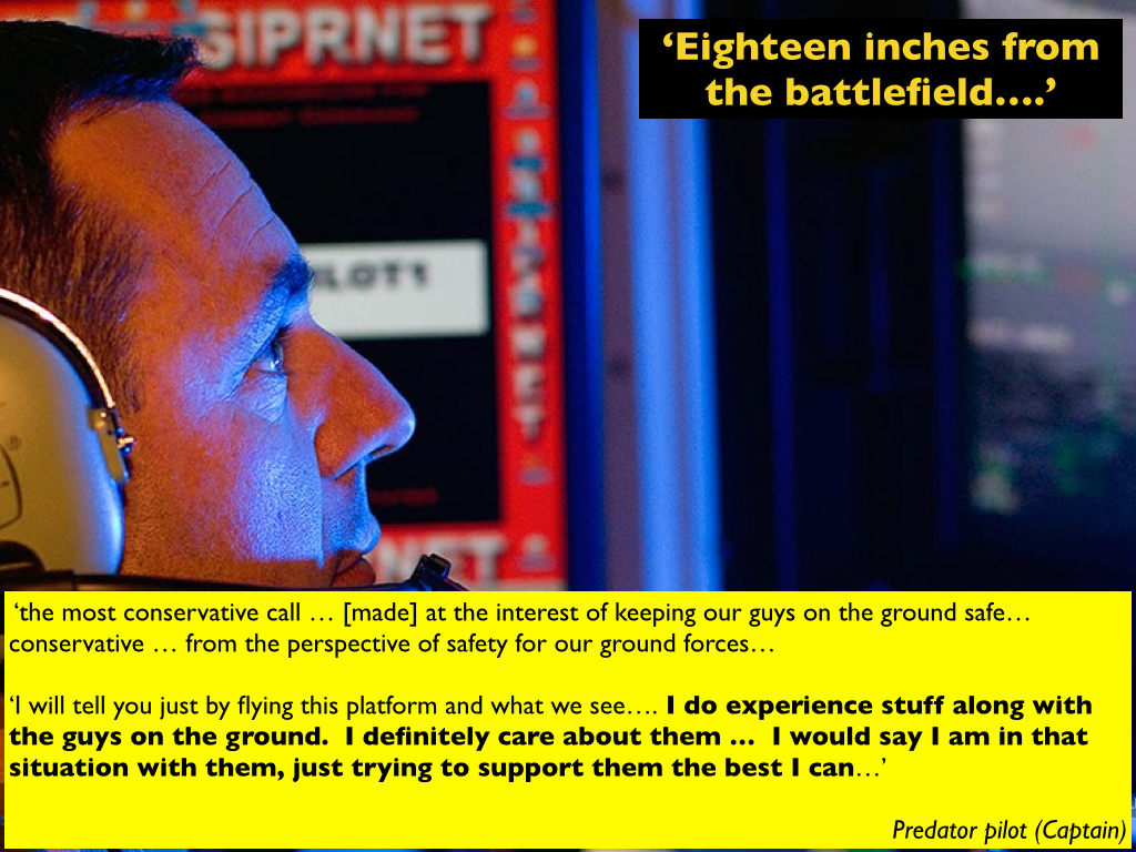


