Gaza, stripped again

As Craig Jones notes over at War, Law and Space, the renewed fighting between Hamas and the IDF is all too familiar; so too is the cartography.

In November 2012, the New York Times published two maps – one showing Israeli cities ‘taking enemy fire’ and the other showing the site of Israeli leaflet drops on Gaza (see my discussion here).

This time round, the only maps available until today have shown the putative range of Hamas’s rockets and the strikes that have taken place in Israel: Gaza might just as well have been a blank space marked ‘here be monsters’ (which is, of course, exactly how the Netanyahu administration wants us to see it).

This evening, Britain’s Telegraph published this map:

IDF and Hamas air strikes 2014

What the latest Israeli assault shows once again, however, is that the key on the left-hand map is misleading.  To juxtapose ‘Israeli-controlled’ with ‘Palestinian territories’ is like juxtaposing ‘fruit’ to ‘apples’.  So many domains of life – and death – in the Palestinian territories, in both the occupied West Bank and Gaza, remain firmly under Israeli control.

‘The land of rotting men’

No man's land

Noam Leshem and Alasdair Pinkerton have embarked on a fascinating new project, Re-inhabiting No Man’s Land: from dead zones to living spaces here:

Nearing the centenary of the First World War, this project explores the ongoing relevance of no-man’s lands in the 21st century. Rather than merely empty, divisive spaces, the project considers the material substance of no-man’s lands, their changing social-cultural meaning and their relevance as productive political and geopolitical spaces.

As a figure of speech, No-Man’s Land is applied to anywhere from derelict inner-city districts and buffer-zones to ‘ungovernable’ regions and tax havens. But what is no-man’s land? What are the conditions that produce it? How is it administered? What sort of human activities do no-man’s lands harbour? These are the questions that prompt us to think about the no-man’s lands not as dead zones, but as living spaces.

WWI consulting a map

News of this arrived from Noam just as I finished the long-form version of Gabriel’s Map: cartography and corpography in modern war, which you can now find under the DOWNLOADS tab (scroll down).  Most of the essay is about the First World War on the Western Front (I explain the title at the start of the essay; it comes from William Boyd‘s Ice-Cream War and, in particular, the First World War in East Africa, and the title of this post comes from Edward Lynch‘s Somme Mud: the experiences of an infantryman in France, 1916-1919), but I also end with these reflections on the 21st century:

In this essay I have been concerned with the First World War but, as we approach its centenary, it is worth reflecting on the ways in which modern warfare has changed – and those in which it has not. Through the constant circulation of military imagery and its ghosting in video games, many of us have come to think of contemporary warfare as optical war hypostatised: a war fought on screens and through digital images, in which full motion video feeds from Predators and Reapers allow for an unprecedented degree of remoteness from the killing fields. In consequence, perhaps, many of us are tempted to think of the wars waged by advanced militaries, in contrast to the First World War, as ‘surgical’, even body-less. These are wars without fronts, whose complex geometries have required new investments in cartography and satellite imagery, and there have been major advances in political technologies of vision and in the development of a host of other sensors that have dramatically increased the volume of geo-spatial intelligence on which the administration of later modern military violence relies. All of this has transformed but not replaced the cartographic imaginary.

And yet, for all of their liquid violence, these wars are still shaped and even confounded by the multiple, acutely material environments through which they are fought. In Sebastian Junger’s remarkable despatch from Afghanistan, he notes that for the United States and its allies ‘the war diverged from the textbooks because it was fought in such axle-breaking, helicopter-crashing, spirit-killing, mind-bending terrain that few military plans survive intact for even an hour.’ If that sounds familiar, then so too will Kenneth MacLeish’s cautionary observations about soldiers as both vectors and victims of military violence:

‘The body’s unruly matter is war’s most necessary and most necessarily expendable raw material. While many analyses of US war violence have emphasized the technologically facilitated withdrawal of American bodies from combat zones in favour of air strikes, smart bombs, remotely piloted drones, and privately contracted fighting forces, the wars in Iraq and Afghanistan could not carry on without the physical presence of tens of thousands of such bodies…

In consequence, the troops have had to cultivate an intrinsically practical knowledge that, while its operating environment and technical armature are obviously different, still owes much to the tacit bodily awareness of the Tommy or the Poilu:

‘In the combat zone there is a balance to be struck, a cultivated operational knowledge, that comes in large part from first-hand experience about what can hurt you and what can’t… So you need not only knowledge of what the weapons and armor can do for you and to you but a kind of bodily habitus as well – an ability to take in the sensory indications of danger and act on them without having to think too hard about it first. When you hear a shot, is it passing close by? Is it accurate or random? Is it of sufficient caliber to penetrate your vest, the window of your Humvee or the side of your tank?’

In the intricate nexus formed by knowledge, space and military power, later modern war still relies on cartographic vision – and its agents still produce their own corpographies.

The notes contain various references to No Man’s Land in the First World War, though I’m increasingly interested in what lies on either side.  One of the reasons so many commentators seem to think that ‘war among the people’ is a recent development is that the imagery of the Western Front draws the eye again and again to No Man’s Land, but behind the front lines on either side were farms, fields, villages and small towns where people continued to live and work amongst the shelling, the gas attacks, and the billeted troops.

As usual, I’d welcome any comments/criticisms/suggestions on the (I hope near final) draft of the essay: an extended version will appear in War material.

When war comes home

After the US invasion of Iraq there were all sorts of artistic interventions that sought to bring home to Americans what was happening in Baghdad.  I described some of them in ‘War and peace’ (DOWNLOADS tab), noting that many of them seemed to take their cue from Martha Rosler‘s double photomontage of ‘Bringing the war home’, in which she re-staged first Vietnam and then the Iraq war in American domestic interiors:

Captives are paraded around gleaming kitchens on leashes, combat troops stalk in living rooms, while beyond the drapes fires flicker, a grieving woman slumps on the deck, and an Army patrol files by. Domestic critics have frequently noted the interchange between security regimes inside and outside the United States; they insist that the ‘war on terror’ ruptures the divide between inside and outside, and draw attention to its impact not only ‘there’ but also ‘here’. But Rosler’s sharper point is to goad her audience beyond what sometimes trembles on the edge of a critical narcissism (‘we are vulnerable too’) to recognise how often ‘our’ wars violate ‘their’ space: her work compels us to see that what she makes seem so shocking in ‘our’ space is all too terrifyingly normal in ‘theirs’.

Several projects made cartographic transpositions or mash-ups: superimposing the bombing of Baghdad on San Francisco (Paula Levine‘s Shadows from another place) or Boston (Alyssa Wright‘s Cherry Blossoms), for example, or choreographing a situationist tour of Baghdad in Brooklyn.  I’ve been more hesitant about these interventions; I know that these three projects were linked to – and in the last case depended on – ground performances, and I know too that it’s possible to undo the abstractness of conventional cartography, to turn it against itself (here I’m thinking of elin o’Hara slavick‘s brilliant Bomb after bomb).

WRIGHT Cherry Blossoms

I’ve now seen a different cartographic transposition that dramatizes the firebombing of Japan during the Second World War by juxtaposing a map of the United States with a map of Japan.  Almost as soon as the war was over there were several visualizations of a nuclear attack on US cities.  The image below comes from Collier’s Magazine in 1950, for a cover story called ‘Hiroshima, USA’; you can access the original here and read more here.  But projects like these still deflect the critical gaze from the horror of what happened there to the horror of what might happen here.  Indeed, that was precisely the point, as Joseph Masco shows in his brilliant essay, ‘”Survival is Your Business”: Engineering ruins and affect in nuclear America’, Cultural Anthropology 23:2 (2008) 361-98; reprinted in Ann Laura Stoler (ed), Imperial debris: on ruins and ruination (Duke, 2013).

Colliers-03-04-1

The problem is redoubled in the case of Hiroshima and Nagasaki, because those two hideous mushroom clouds have so often blocked our view of the firebombing of Japanese cities that preceded the two nuclear attacks.  Here the work of David Fedman and Cary Karacas on bombing Japan is indispensable, not least for its illuminating discussion of the central role of cartography (see Cary’s bilingual historical archive here).

In fact in 1945 the United States Air Force produced a map in which the earlier bombing campaign was projected on to a map of the United States:

FirebombsMapFinal-1.jpg.CROP.original-original

And this was the starting-point for Alex Wellerstein‘s remarkable intervention, whose critical force comes precisely from its juxtaposition (rather than simple superimposition) of the two maps: what happened in Japan is visibly there, magnified rather than marginalized through the map of the continental United States.  In fact, when you click on the interactive a line appears linking an American city to its equivalent target-city in Japan:

Firebombs-USA-interactive-600x321


Mapping violent conflict

The Heidelberg Institute for International Conflict Research has published its Conflict Barometer for 2013:

Violent conflicts 2013 HEIDELBERG

The full report can be downloaded here; it includes a detailed explanation of methodology and sources, many more maps, and a series of detailed regional surveys.

There are, of course, many other projects that attempt to monitor the macro-geography of armed conflict that also make their databases available for research, including the Correlates of War project (data from 1816 on), the Armed Conflict Dataset maintained by UCDP/PRIO (see also here; data from 1946 on) – both these are global – and the Armed Conflict Location & Event Data Project (ACLED) which provides a much more detailed, sub-regional mapping and claims to be ‘the most comprehensive public collection of political violence data for developing states.’  I’ve pasted an example of their sub-regional mapping below; the original is here, along with others for the DRC and Zimbabwe, while maps plotting the activities of Boko Haram, the Lord’s Resistance Army and other conflicts are available here and here.

ACLED_Infographic_Al-Shabaab-Activity-Map-721x1024

I also greatly admire the Event Data on Conflict and Security (EDACS) produced by Sven Chojnacki and his colleagues in Berlin, and the disaggregated analyses they provide.  Like ACLED, this also includes a remarkably detailed time-space analysis of violence in Somalia:

CHOJNACKI Somalia

You can find out more about the project from the special issue of International Interactions 38: 4 (2012) on Event Data in the Study of Conflict.

A map that blogs

I described a series of maps of the violence in Syria a few weeks ago, and today Al Jazeera provided a new interactive that maps the different groups that compose the Syrian opposition; here’s a screenshot of what is, of evident necessity, a rough-and-ready approximation of a fluid situation:

Mapping Syria's rebellion

And since I recently mentioned Riverbend‘s blog from Baghdad during the US-led occupation, I thought I should list some of the blogs being written out of Syria.  I do this with trepidation, after the odious fiasco of the Gay Girl in Damascus blog, which turned out not only to be written by an American man but also to describe the ‘arrest’ of its ‘author’, ‘Amina Haraf’: several of the bloggers I list below (like Razzan Ghazawi) really have been arrested, interrogated or expelled.  If I’ve overlooked any other insightful blogs from Syria, please let me know.

Free Halab (‘a blog about the Syrian Revolution’) includes reports from Aleppo, Homs and Damascus (including video, and some helpful maps of the situation in different cities by Cedric Labrousse); other posts from Homs are here (and an excellent discussion of them and their author here), and from Northern Syria here.

Maysaloon is here – singled out with good reason in the Guardian – and Razzan Ghazawi‘s (according to the Telegraphiconic‘) blog is here.  It includes this powerful poem, The Revolutionary Cannot Speak (and I suspect the Telegraph could not read it either); it also might explain the otherwise strange title I’ve given this post.

We were taught that the sun does not always shine
We were taught
Thousands mirrors worth a truthful face

We tried to unlearn, those many lines our memory cannot forsake
The revolution, we repeated, the revolution is the solution
A task we may never undertake

Our revolution is pure, and it is not White
It’s grounded and rooted in our sinful eyes

We are the people
We are the words of wisdom
Your books and think-tanks so eloquently did not foresee

The power lies in people
The Black Palestinian painfully teaches us

Why do I feel that I’ll soon be the last Syrian alive
40, 000 corpses can never lie
They lay underneath our sacred soil
They haunt us in protests
Occupy our banners
and online profiles

A burden I cannot bear
So like others, I long for the day I join the Shuhada

I cannot be the last Syrian alive
I cannot be the Syrian who left, and still alive

You think “critically” of our raw revolution, you say
You think and cite our savagery with references of youtube videos
You are as powerful as the states you oppose
States silence us with machine guns
They send us sleepless killers in black suits
States fight among each other
We have learned the drill

But you, like the White, speak on behalf of us
You are the intellectual whose privileged voice silenced our indigenous voices
You’re no friend of mine
The leftist, feminist and the pro Palestinian activist
Are names of spaces you proudly occupy
To me, they’re just another privileged class
You made it possible to become my enemy

Yes, I have said the word “enemy”
And I would say it in the class you teach
Below the many articles you publish
Where you could tell the world how my struggle isn’t consistent with yours

What is your struggle, I wonder
When you’re the diasporic subject and I am the postcolonial
I stand in front of systems, machines and propaganda
In my besieged land

Your battle has become my dream of freedom
Your intellect has become another bullet in my chest
A “friendly fire,” I do not call it

I am being silenced by your pen

The revolutionary cannot speak
She may never speak for years to come
She writes in her mother tongue
Speaks folky words and songs your memory can no longer grasp
The revolutionary speaks to her gender-less comrades
And you
The powerful male intellectual
You are not one.

Bombing Japan

I’ve drawn attention to the remarkable work of Cary Karacas before, notably the mesmerising essay he co-authored with David Fedman, ‘A cartographic fade to black: mapping the destruction of urban Japan in World War II’ [Jnl. historical geography 38 (2012) 306-28], which quite rightly won the prize for the paper published in the journal that made ‘the greatest contribution to the advancement of scholarship in historical geography’ in 2012; it’s available here.  Bombing depends upon a whole series of cartographic visions, and there is something exquisite about using maps to expose rather than plan violence from the air like this.

AAF-Target-Chart-Japan-No293-Tokyo-e1315753005250

You can also get a sense of their work from this beautifully illustrated essay by Eric Jaffe for the Atlantic last year, ‘Mapping urbicide in World War II’, and from this special (open-access) issue of Asia-Pacific Journal: Japan Focus Cary edited with Bret Fisk on ‘The fire-bombing of Tokyo: views from the ground’.

Working with Bret and translator Eri Tsuji, Cary also launched a new website, Japan Air Raids.org, which is a bilingual (hooray!) digital archive providing an extraordinary range of primary and secondary materials on the US bombing of Japan in the Second World War.

In Japan it took over twenty years following the end of the World War II before people began to make a concerted effort to remember the incendiary raids that destroyed a significant percentage of most of Japan’s cities, wiped out a quarter of all housing in the country, made nine million people homeless, killed at least 187,000 civilians, and injured 214,000 more (source). Thanks to the many Japanese citizens who over the last forty years have labored to write down survivor accounts, locate and preserve various records, and analyze the destruction of urban Japan (and the concurrent suffering and social upheaval that occurred), the history of the air raids has taken root in Japan in a variety of ways. Numerous books and articles have been published, resource centers and peace museums have been built, and both individuals and associations continue to carry out important research.

Outside of Japan, the lag time to look closely at the impacts of the air raids is even more pronounced. In 1977, historian Gordon Daniels lamented the fact that academics had largely ignored the air raids on Japan – and the so-called Great Tokyo Air Raid in particular – as a subject of inquiry. Little has changed since this observation. While a handful of important English-language books and articles have appeared since then, most deal with the topic strictly from the standpoint of examining, and on occasion criticizing, U.S. strategic bombing doctrines and campaigns. Analyses about what the air raids entailed for the Japanese civilians on the ground and the cities in which they lived have yet to be written. Consequently, interested citizens and intellectuals who cannot read Japanese have minimal access to materials that shed light on the devastating effects of the incendiary bombing campaign on Japanese communities, cities and society. Additionally, while considerable English-language primary and secondary source documents related to the air raids exist, to date they have been beyond the reach of most people save for a handful of individuals who possess the inclination, time and resources required to visit the physical archives holding them.

By taking advantage of technological developments that allow for digitization, storage, and global retrieval of documents, we hope that this digital archive will play an important role in encouraging people to learn about and further research this area, and in fostering collaboration among a variety of individuals and groups. Additionally, by democratizing archival access to materials related the Japan air raids, we hope to open this field to the general public, scholars, professional and lay researchers, university students, and even middle/secondary school educators and their pupils.

Japan Air Raids.org screenshot

The project is ongoing, but it’s already clear that this is a stunning achievement – visually, intellectually and politically – and a truly generous and absolutely indispensable resource.

‘It sounds like a whisper’

BUNGE Fitzgerald 1st edn

BUNGE Fitzgerald 2nd ednRemember Bill Bunge‘s Fitzgerald: geography of a revolution (1971)?   Trevor Barnes and Nick Heynen celebrated its republication in 2011 by the University of Georgia Press:

‘Forty years after its publication, Fitzgerald remains fresh, energetic, compelling, and relevant. One of Bunge’s purposes in Fitzgerald was to do human geography differently. He pushed the discipline in a new direction, helping to transform it into something else. If we see Fitzgerald differently now compared to when it was written it is because the discipline in which we gave become socialised has significantly altered. Fitzgerald helped to change it. We all contain, perhaps more than we would like to think, perhaps more than we would like to know, a little bit of Bunge, a little bit of Fitzgerald.’

You can find the full set of commentaries in Progress in human geography 35 (5) (2011).  What distinguished Fitzgerald, apart from its driving, passionate narrative, was a series of remarkable, original and imaginative maps of the Detroit neighbourhood where Bunge made his home.  These were not decorations – many of them were deeply troubling – but an indispensable means of driving the argument home.

Now Denis Wood has followed in Bunge’s footsteps – readers will surely know The power of maps (which he wrote and later re-thought with John Fels) – using maps to tell a series of exquisitely layered stories about Boylan Heights in Raleigh, North Carolina in Everything sings: maps for a narrative atlas (2013).  His publisher Siglio explains:

Iconoclastic geographer Denis Wood has created an atlas unlike any other. He surveys his small, century-old neighborhood in Raleigh, North Carolina by first paring away the inessential “map crap” (scale, orientation, street grids), then by locating the revelatory in the unmapped and unmappable: radio waves permeating the air, the paperboy’s route in space and time, the light cast by street lamps, Halloween pumpkins on porches. His joyful subversion of the traditional notions of mapmaking forge new ways of seeing not only this particular place, but also the very nature of place itself.

DENIS WOOD Everything Sings

In a long and lively interview about the book, re-published today on Guernica, Denis argues:

Maps are just nude pictures of reality, so they don’t look like arguments. They look like “Oh my god, that’s the real world.” That’s one of the places where they get their kick-ass authority.

If you’re having trouble explaining the politics of ‘deconstructing the map’, then this may be a good place to start.  And do click on the thumbnails above the interview for a selection of 20 images from the expanded edition of Everything sings.  More on Denis’s work and access to his writing (and much more besides) at his website here.

WAINWRIGHT GeopiracyOf course other, markedly ugly narratives can be inscribed on the world through maps.  Fitzgerald was a collaborative project, and it drew on the work of the Detroit Geographical Expedition.  But there have been other, decidedly invasive ‘geographical expeditions’ – like the American Geographical Society’s Bowman Expedition (Zoltan Grossman provides a rich series of sources here, and Joel Wainwright‘s Geopiracy: Oaxaca, militant empiricism and geographical thought (2012) is indispensable).  So it’s good to know that Denis is currently completing another book (with Joe Bryan), Weaponizing Maps: bringing the conquest home, which is an incisive analysis of military mapping of indigenous populations in Canada, Colombia, Honduras, Mexico and Nicaragua and the imbrications of cartographic Reason with contemporary counterinsurgency.

I expect both Bill Bunge and Tracy Chapman would agree there’s a revolution needed there too.

Battle of the maps

Books & Ideas has a translated interview with Michel Foucher, ‘A world out of key’, on cartography and geopolitics.

Foucher is a former diplomat and now a professional geographer (though no doubt each requires the skills of the other).  A graduate of the Sorbonne, he was special envoy to the Balkans and the Caucasus (1999), adviser to the French Foreign Minister (1997-2002), head of the Policy Planning Staff of the Foreign Ministry (1999-2002), French Ambassador to Latvia (2002-2006), and Ambassador at large for European Issues (2007).  He is currently Director of Studies and Research at the Institut des hautes études de défense nationale and Professor of Applied Geopolitics at the École Normale Supérieure in Paris.  At the 19th Festival of Geography he took part in a roundtable on ‘Les nouveaux territoires de la guerre’ (below; video here), and repeatedly invokes Clausewitz to insist that ‘the geographer is [the person] who looks over the hill’.

FOUCHER Nouveaux territoires de la guerre

Prolonging that martial note, the current interview is based on Foucher’s recent book, La bataille des cartes.  The analysis is conventional enough – though I like Foucher’s image of a ‘dissonant world’, which could be made to play off Edward Said‘s ‘contrapuntal geographies’ (hence the title of the interview).  It’s a wide-ranging discussion, from the meaning of geopolitics and questions about ‘strategic autonomy’ in our dissonant world, through reflections on territorialisation (and ‘maritimisation’ – works much better in French) and the power of imaginative geographies embedded in maps, to b/ordering and the implications of the Arab uprisings for the imaginaries installed by colonial cartographies.  (You can find an earlier interview on borders, security and identity here). The B&I translation is clunky in places, but it’s a good survey for a public audience.  Above all, Foucher is determined to counter the view that geography is what Jean-Claude Guillebaud called ‘a dead star’.

A Battle of Maps

As Stuart Elden noted, the project from which it derives is available not only as a book but in a digital version for the iPad, A Battle of the Maps, in either French or English. You can try it out free (‘Lite’ – just the first two sections) or download the full version here.

There’s an irony in all this; Foucher notes that ‘in an age dominated by screens’ the market depends on ‘the sham of “it’s true because it’s in colour”, a wordless geography’.  Foucher seeks to undo this cartographic rhetoric through 74 Le Monde Diplo-style  maps and accompanying text, and some of them – even in the free version – are suitably imaginative: ‘The world according to Standard & Poor’s’ or ‘The banker’s mental map’.  As Foucher notes, ‘geopolitical rhetoric enables experts who are neither geographers nor political scientists, still less cartographers, to seize commercial opportunities.’  And as those two maps also imply, many of them aren’t even experts….

Gabriel’s map

Gabriel's map posterThe video of  “Gabriel’s map: cartography and corpography in modern war”, a lecture I gave as part of the University of Kentucky’s Committee on Social Theory 2013 series on “Mapping” in January, is now available here.

The splendid poster (left) mangles the title, but any mangling of the content is down to me!

I’m presently re-working this as an essay, but I’ll eventually post the pdf of the slides: more soon.  In the meantime, I’d welcome any comments, suggestions and criticisms.

UPDATE:  You can now access the slides for this presentation as a pdf under DOWNLOADS, but please remember that this was the first version of the presentation – I expect to be revising it over the coming weeks – and if you use any of them (for teaching purposes only) please credit the source.

‘Stop, hey, what’s that sound?’

I’ve used this Buffalo Springfield song before

there’s something happenin’ here
what it is ain’t exactly clear
there’s a man with a gun over there…

stop, hey, what’s that sound?

– and I’ve posted about the sound of war before too, here and here.  This post is connected to both of them, but it also follows directly from my more recent post on bodies

McCARTHY C
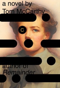
An age ago Trevor Barnes recommended Tom McCarthy‘s novel C to me, and I’ve been re-reading it these last few days. There’s an extraordinary passage where McCarthy’s protagonist Serge, an observer with the Royal Flying Corps during World War I, is being driven to Nieppe when his truck  detours ‘to drop off some piano wire’ to a special unit in the woods north of Vitriers.

Inside the main [hut], he finds a huge square harp whose six strings are extended out beyond their wooden frame by finer wires that run through the hut’s air before breaching its boundary as well, cutting through little mouse-holes in the east-facing wall. In front of the harp, like an interrogation lamp, a powerful bulb shines straight onto it; behind it, lined up with each string, a row of prisms capture and deflect the light at right angles, through yet another hole cut in the hut’s wall, into an unlit room adjoining this one. There’s a noise coming from the adjoining room: sounds like a small propeller on a stalled plane turning from the wind’s pressure alone. “What is this place?” Serge asks. “You’re an observer, right?” the slender-fingered man says. Serge nods. “Well, you know how, when you’re doing Battery Location flights, you send down K.K. calls each time you see an enemy gun flash?” “Oh yes,” Serge answers. “I’ve always wondered why we have to do that …” “Wonder no more,” the man says with an elfin smile. “The receiving operator presses a relay button each time he gets one of those; this starts the camera in the next room rolling; and the camera captures the sound of the battery whose flash you’ve just K.K.’d to us. You with me?” “No,” Serge answers. “How can it do that?” “Each gun-boom, when it’s picked up by a mike, sends a current down the wires you just pissed on,” the man continues, “and the current makes the piano wire inside this room heat up and give a little kick, which gets diffracted through the prisms into the next room, and straight into the camera.” “So you’re filming sound?” Serge asks. “You could say that, I suppose,” the man concurs.

Sound ranging traces

Still puzzled, he follows the man into another hut:

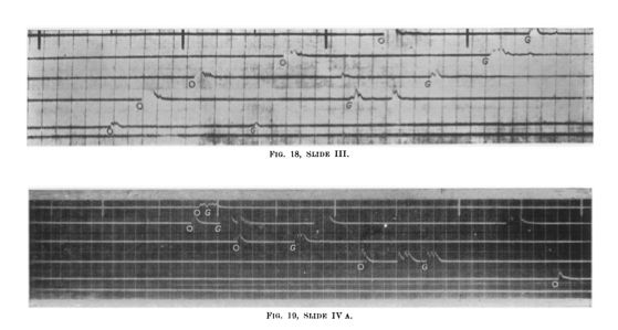
The interior’s suffused with red light. At a trough propped up against the far wall, a man with rolled-up sleeves is dunking yards of film into developing liquid, then feeding it on from there into a fixing tank. As the film’s end emerges from this tank in turn, he holds it up, inspects it and tears off sections, clipping these with clothes pegs to a short stretch of washing line, from where they drip onto the discarded strips on the room’s floor below them. “Yuk,” Serge whispers beneath his breath. “What?” the slender-fingered man asks. “Nothing,” he replies. “Look here,” Serge’s guide says, unclipping a strip of the developed film and pointing at dark lines that run, lengthways and continuous, along its surface. The lines—six of them—are for the most part flat; occasionally, though, they erupt suddenly, and rise and fall in jagged waves, like some strange Persian script, for half an inch, before settling down and running flat again. On the film’s bottom edge, beside the punch-holes, a time-code is marked, one inch or so for every second. The jagged eruptions appear at different points along each line: staggered, each wave the same shape as the one on the line below it, but occurring a quarter of an inch (or three-tenths of a second) later. “So,” Serge’s elfin guide continues, “these kicks are made by the sound hitting each mike; and they get laid out on the film at intervals that correspond to each mike’s distance from the sound. You see them?” “Yes,” Serge answers. “But I still don’t—” “These ones ready to take through?” the guide asks the developer. The other man nods; with his piano-player’s fingers, the guide unclips the other drip-dried strips, then leads Serge out to yet another hut. This one’s wall has a large-scale map taped to it; stuck in the map in a neat semi-circle are six pins. Two men are going through a pile of torn-off, line-streaked film-strips, measuring the gaps between the kicks with lengths of string; then, moving the string over to the map slowly, careful to preserve the intervals, they transfer the latter onto its surface by fixing one end of the string to the pin and holding a pencil to the other, swinging it from side to side to mark a broad arc on the map. “Each pin’s a microphone,” the slender-fingered man explains. “Where the arcs intersect, the gun site must be.” “So the strings are time, or space?” Serge asks. “You could say either,” the man answers with a smile. “The film-strip knows no difference. The mathematical answer to your question, though, is that the strings represent the asymptote of the hyperbola on which the gun lies.”

Serge has stumbled into what Peter Liddle called ‘the Manhattan Project of the 1914-18 war’: sound ranging.  It was a technique first developed by the French and German militaries  – a German sound ranging analysis section is shown below – taken up (warily) by the British (Berton claims their  old-school gunners at first thought it radical nonsense) and refined by the Canadians. As McCarthy’s brilliant reconstruction shows, it involved using sound to locate enemy artillery batteries.

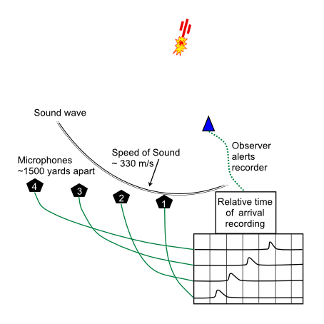
The usual configuration was to have six ‘Tucker’ microphone stations at carefully surveyed intervals along an arc 4000 yards behind the front line with two observation posts in front of them, all linked to a recording station in the rear by 40 miles of wire.  When the observers saw a gun flash or heard its boom they sent a signal that activated the oscillograph and film recorder.  In the course of 1916 the British established eight of these sound-ranging sections, each plotting battery positions on base maps supplied by ‘Maps GHQ’.  In ideal conditions (which were rare) the operation could be completed for a single battery within three minutes (using graphical rather than computational methods) and with an accuracy of 25-100 yards (for more, see J.S. Finan and W.J. Hurley, ‘McNaughton and Canadian Operational Research at Vimy’, Jnl. of the Operational Research Society 48 (1) (1997) 10-14).

Analysis section of German sound ranging troop 1917

The single best source on this – though the title sounds like Flash Gordon – is John Innes‘s Flash spotters and sound rangers: how they lived, worked and fought in the Great War (1935), but Pierre Berton‘s Vimy (1986) has some useful summary pages on the Canadian role in its development. There is also a truly excellent survey that places sound-ranging in the wider context of the ‘battlefield laboratory’ in Roy MacLeod, ‘Sight and sound on the Western Front: surveyors, scientists and the “battlefield laboratory”, 1915-1918’, War & Society 18 (1) (2000) 23-46.  For more technical discussions, Peter Chasseaud‘s Artillery’s astrologers: a history of British survey and mapping on the Wester Front 1914-1918 (1999) is a key source, but there is also an exemplary (short) explanation here, from which I’ve borrowed the simplified summary diagram below.

Sound ranging

The Germans were evidently impressed by the efficacy of the Allied system, as this directive issued by General Ludendorff shows:

According to a captured English document the English have a well- developed system of sound-ranging which in theory corresponds to our own. Precautions are accordingly to be taken to camouflage the sound: e.g. registration when the wind is contrary, and when there is considerable artillery activity, many batteries firing at the same time, simultaneous firing from false positions, etc. The English have an objective method (self-recording apparatus). It is important to capture such an apparatus. The same holds good on the French front.

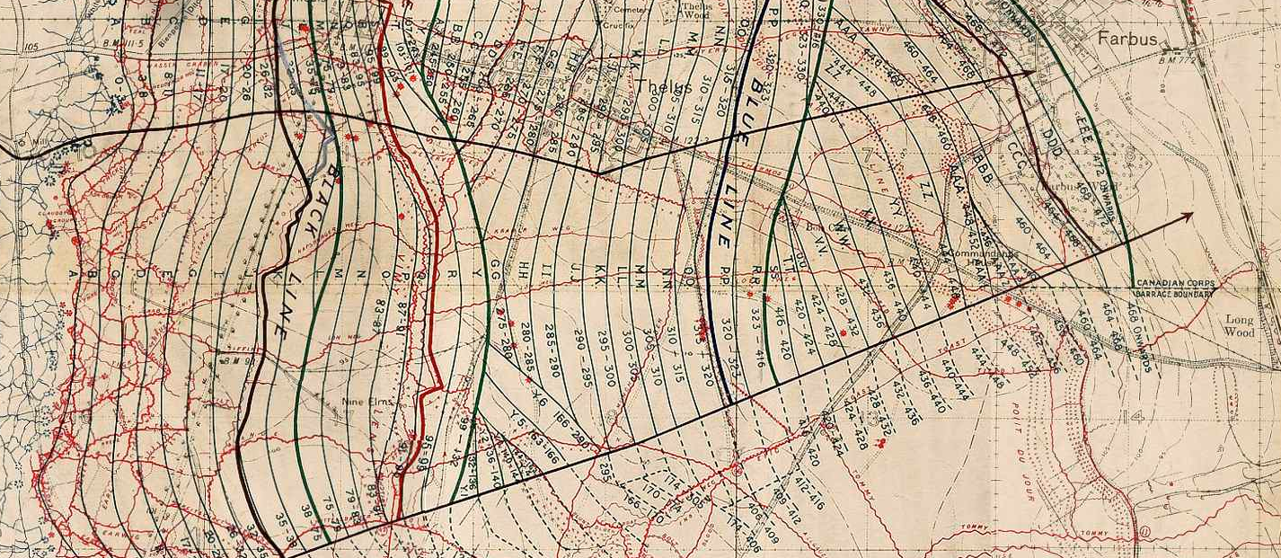
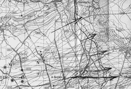
Since most of the killing and destruction was the work of the artillery, these counter-battery operations were a crucial part of the ground war.  Multiple sources were used, including aerial reconnaissance, balloon observation and flash spotting as well as sound ranging, and when combined these could eventually locate enemy guns to within 5-25 yards.  This map of German artillery intelligence for Vimy in March 1917 shows something of the power and complexity of this ‘acoustic cartography’:

German artiller intelligence map Enemy batteries known with certainty to be firing and spotted 15 to 22 March 1917 Vimy

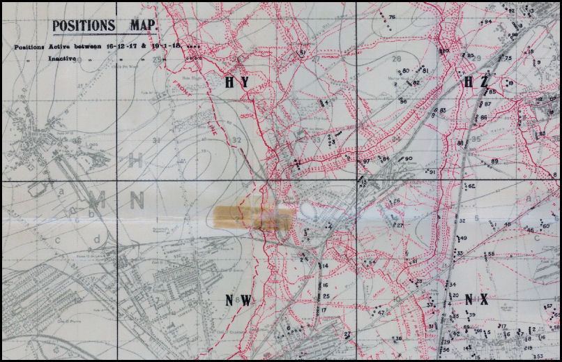
Maps showing the location of enemy batteries (‘Positions maps’ like the British one below) were issued on a regular and eventually even a daily basis.

Positions map. December 1917-January 1918

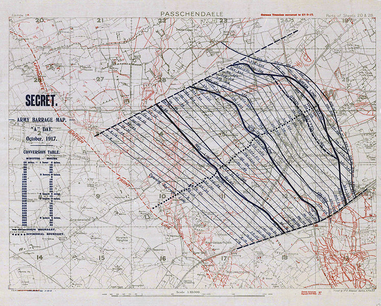
This was all part of a more general metricisation of the battlefield – hideously appropriate for the killing machine that was industrialized warfare – which you can also see in the ‘barrage maps’ that choreographed the moving curtain of artillery fire behind which troops were supposed to advance on the enemy lines.  John Keegan is very good on what he called ‘the mathematics of the barrage’ in his The Face of Battle, and from his aircraft high above No Man’s Land, Billy Bishop described it as ‘clockwork warfare’:

The waves of attacking infantry as they came out of their trenches and trudged forward behind the curtain of shells laid down by the artillery, were an amazing sight. The men seemed to wander across No Man’s Land, and into the enemy trenches, as if the battle was a great bore to them. From the air it looked as though they did not realise that they were at war and were taking it all entirely too quietly. That is the way with clock-work warfare. These troops had been drilled to move forward at a given pace. They had been timed over and over again in marching a certain distance, and from this timing the “creeping,” or rolling barrage which moved in front of them had been mathematically worked out.

BARRAGE MAP bataille-ypres-passchendaele-carte-secret

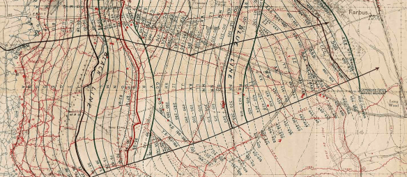
Here’s part of the barrage map for Vimy, which shows the calibration even more clearly:

Vimy barrage map 1917 (extract)

McCarthy captures this ‘clockwork’ movement perfectly when Serge looks down from his aircraft while spotting for artillery:

As the second-hand needle moves across the final quarter-segment of his watch’s face, Serge feels an almost sacred tingling, as though he himself had become godlike, elevated by machinery and signal code to a higher post within the overall structure of things, a vantage point from which the vectors and control lines linking earth and heaven, the hermetic language of the invocations, its very lettering and script, have become visible, tangible even, all concentrated at a spot just underneath the index finger of his right hand which is tapping out, right now, the sequence C3E MX12 G … Almost immediately, a white rip appears amidst the wood’s green cover on the English side. A small jet of smoke spills up into the air from this like cushion stuffing; out of it, a shell rises. It arcs above the trench-meshes and track-marked open ground, then dips and falls into the copse beneath Serge, blossoming there in vibrant red and yellow flame. A second follows it, then a third. The same is happening in the two-mile strip between Battery I and its target, and Battery M and its one, right on down the line: whole swathes of space becoming animated by the plumed trajectories of plans and orders metamorphosed into steel and cordite, speed and noise. Everything seems connected: disparate locations twitch and burst into activity like limbs reacting to impulses sent from elsewhere in the body, booms and jibs obeying levers at the far end of a complex set of ropes and cogs and relays. The salvos pause; Serge plots the points of impact on his clock-code chart, then sends adjustments back to Battery E, which fires new salvos that land slightly to the north of the first ones. 

There’s a lot more to say about this, which I plan to do in the full presentation, but what interests me at least as much is the way in which this precision (Gabriel’s ‘order and reasonableness’) – so clear and crystalline when plotted on maps or seen from the air – was confounded on the ground, not least by the shattered landscape of craters, trenches and barbed wire and by the vile agency of what Siegfried Sassoon called the ‘plastering slime’ that clawed and dragged at the soldiers’ bodies and which was erased from what Edmund Blunden called the ‘innocuous arrows’ and ‘matter-of-fact symbols’ of the maps and aerial photographs.

More particularly, I’m interested (here) in the production of an altogether more sensuous soundscape, part of the corpography that danced such a deadly gavotte with cartography that I sketched out in my previous post.  In Touch and intimacy Santanu Das argues that

‘The mechanised nature of the First World War severed the link between sight, space and danger, a connection that had traditionally been used to structure perception in wartime.  This disjunction resulted in an exaggerated investment in sound.’

The memoirs, letters and diaries from the Western Front confirm that the hideous noise of battle worked its way inside the very body of the soldier.  I’ve got pages of examples, but here is just one, Edward Lynch in Somme Mud (and, for that matter, in Somme mud):

‘The shells are missing us by a matter of yards.  Noise is everywhere.  We lie on the shuddering ground, rocking to the vibrations, under a shower of solid noise we feel we could reach out and touch.  The shells come, burst and are gone, but that invisible noise keeps on – now near, now far, now near, now far again.  Flat, unceasing noise.’

I’ve emphasised the passage that simply resonates with what I described previously as a haptic geography.  And so, not surprisingly, the same sources also show that, just as the landscape was inhabited, so too was knowledge of it; that knowing those deadly sounds – ‘knowing the score’, I suppose – was a vital part of staying alive.  Here is an extended passage from A.M. Burrage‘s War is war:

We are becoming acclimatised to trench warfare. We know by the singing of a shell when it is going to drop near us, when it is politic to duck and when one may treat the sound with contempt. We are becoming soldiers. We know the calibres of the shells which are sent over in search of us. The brute that explodes with a crash like that of much crockery being broken, and afterwards makes a “cheering” noise like the distant echoes of a football match, is a five-point-nine. The very sudden brute that you don’t hear until it has passed you, and rushes with the hiss of escaping steam, is a whizz-bang. For a perfect imitation of a whizz-bang, sit by the open window of a railway compartment and wait until an express train passes you at sixty miles an hour. The funny little chap who goes tonk-phew-bong is a little high-velocity shell which doesn’t do much harm. “Minnies” and “flying pigs” which are visible by day and night come sailing over like fat aunts turning slow somersaults in mid-air. Wherever one may be, and wherever they may be going to drop, they always look as if they are going to fall straight on top of one. They are visible at night because they have luminous tails, like comets. The thing which, without warning, suddenly utters a hissing sneeze behind us is one of our own trench-mortars. The dull bump which follows, and comes from the middle distance out in front, tells us that the ammunition is “dud.” The German shell which arrives with the sound of a woman with a hare-lip trying to whistle, and makes very little sound when it bursts, almost certainly contains gas.

 We know when to ignore machine-gun and rifle bullets and when to take an interest in them. A steady phew-phew-phew means that they are not dangerously near. When on the other hand we get a sensation of whips being slashed in our ears we know that it is time to seek the embrace of Mother Earth.

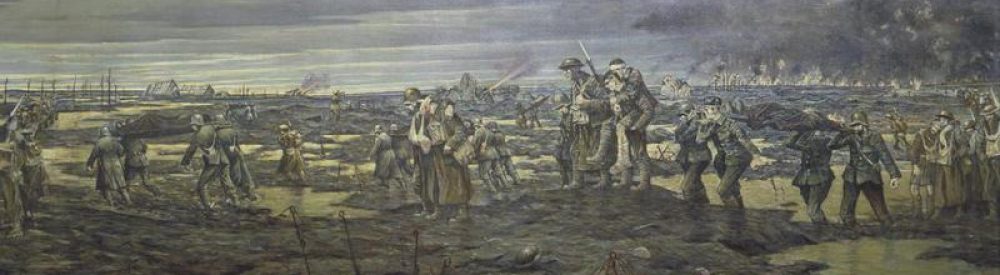
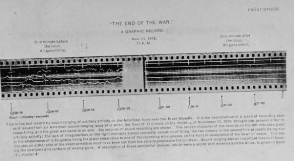
The end of the war was apprehended in both registers, and this frontispiece from Benedict Crowell’s Demobilization (1920) shows how an American sound-ranging station captured the moment the guns fell silent:

The end of the war: 11 a.m. on 11 November 1918

‘Stop, hey, what’s that sound?’