Black Friday

Just released: a joint investigation by Amnesty International and Forensic Architecture reconstructs Israel’s siege of Rafah during its assault on Gaza in 2014.  You can read the Executive Summary here and access the full report, Black Friday: carnage in Rafah, here.

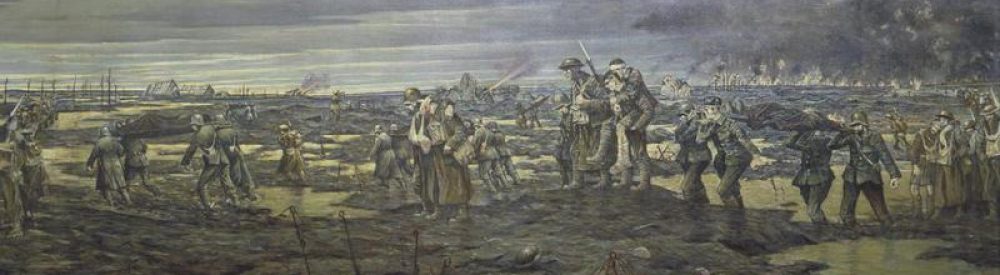
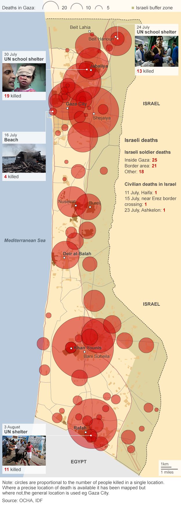
In Rafah, the southernmost city in the Gaza Strip, a group of Israeli soldiers patrolling an agricultural area west of the border encountered a group of Hamas fighters posted there. A fire fight ensued, resulting in the death of two Israeli soldiers and one Palestinian fighter. The Hamas fighters captured an Israeli officer, Lieutenant Hadar Goldin, and took him into a tunnel. What followed became one of the deadliest episodes of the war; an intensive use of firepower by Israel, which lasted four days and killed scores of civilians (reports range from at least 135 to over 200), injured many more and destroyed or damaged hundreds of homes and other civilian structures, mostly on 1 August.

In this report, Amnesty International and Forensic Architecture, a research team based at Goldsmiths, University of London, provide a detailed reconstruction of the events in Rafah from 1 August until 4 August 2014, when a ceasefire came into effect. The report examines the Israeli army’s response to the capture of Lieutenant Hadar Goldin and its implementation of the Hannibal Directive – a controversial command designed to deal with captures of soldiers by unleashing massive firepower on persons, vehicles and buildings in the vicinity of the attack, despite the risk to civilians and the captured soldier(s).

The report recounts events by connecting various forms of information including: testimonies from victims and witnesses including medics, journalists, and human rights defenders in Rafah; reports by human rights and other organizations; news and media feeds, public statements and other information from Israeli and Palestinian official sources; and videos and photographs collected on the ground and from the media.

Satellite imagery Rafah 1 August 2014

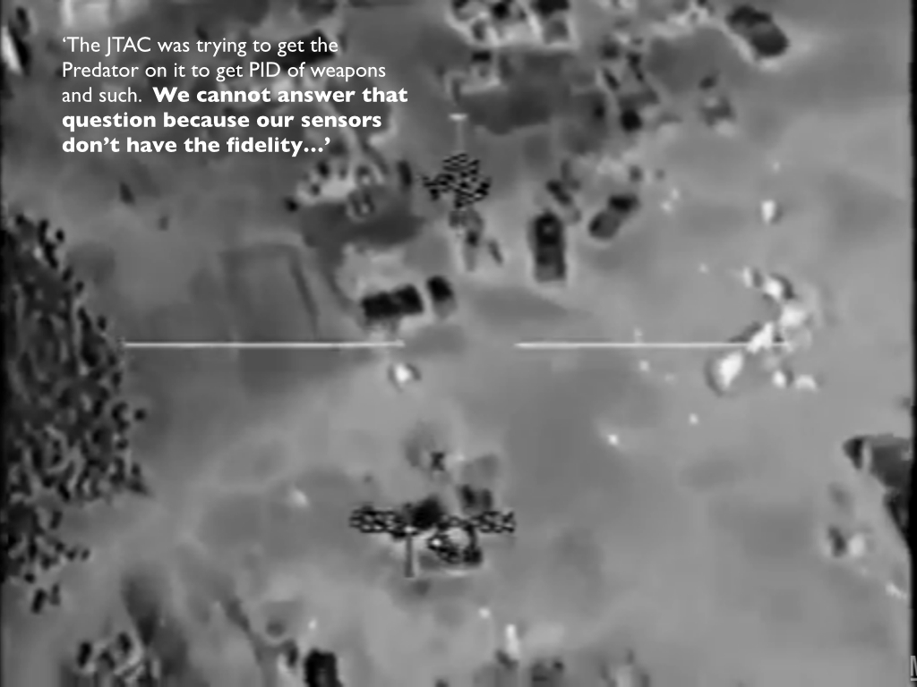
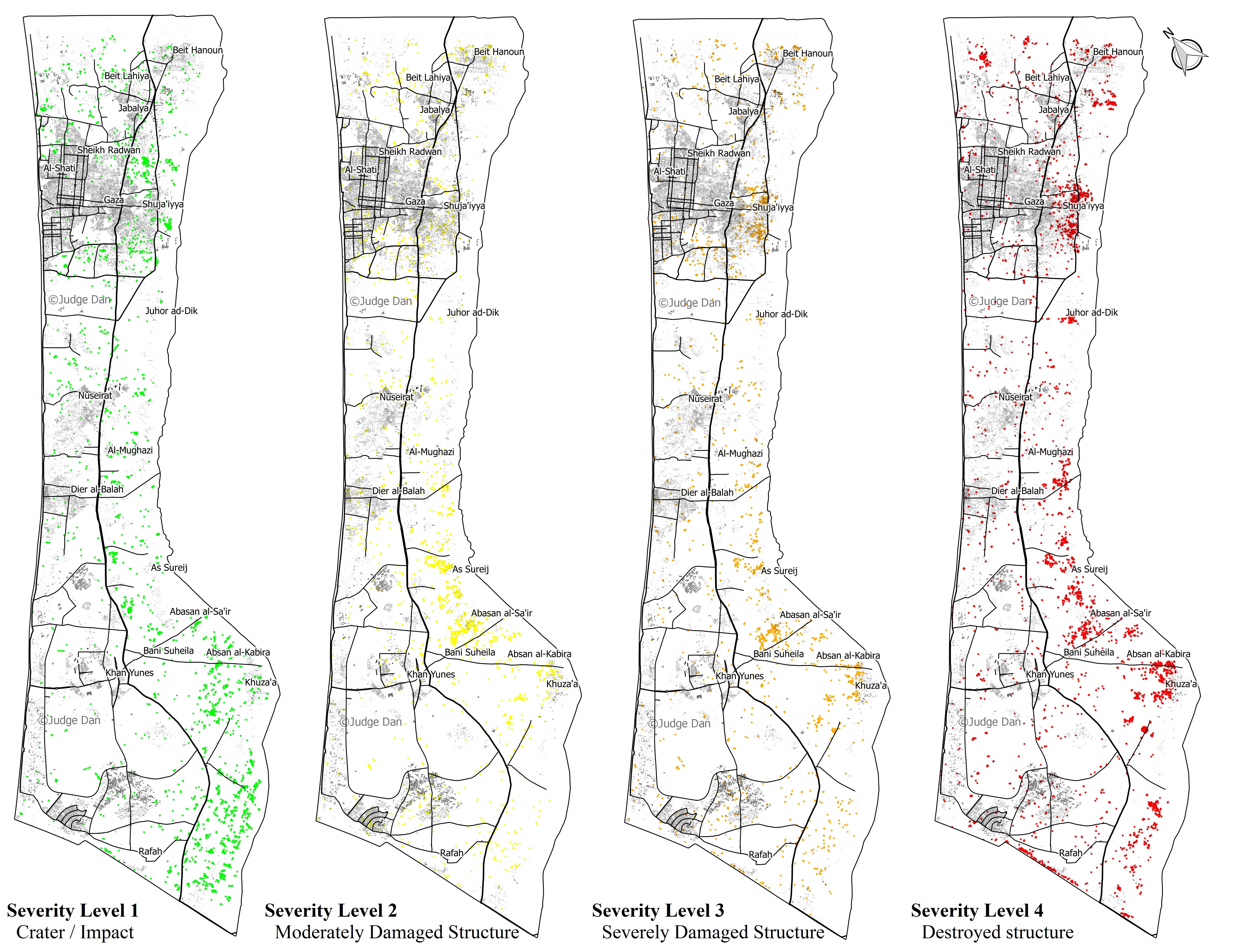
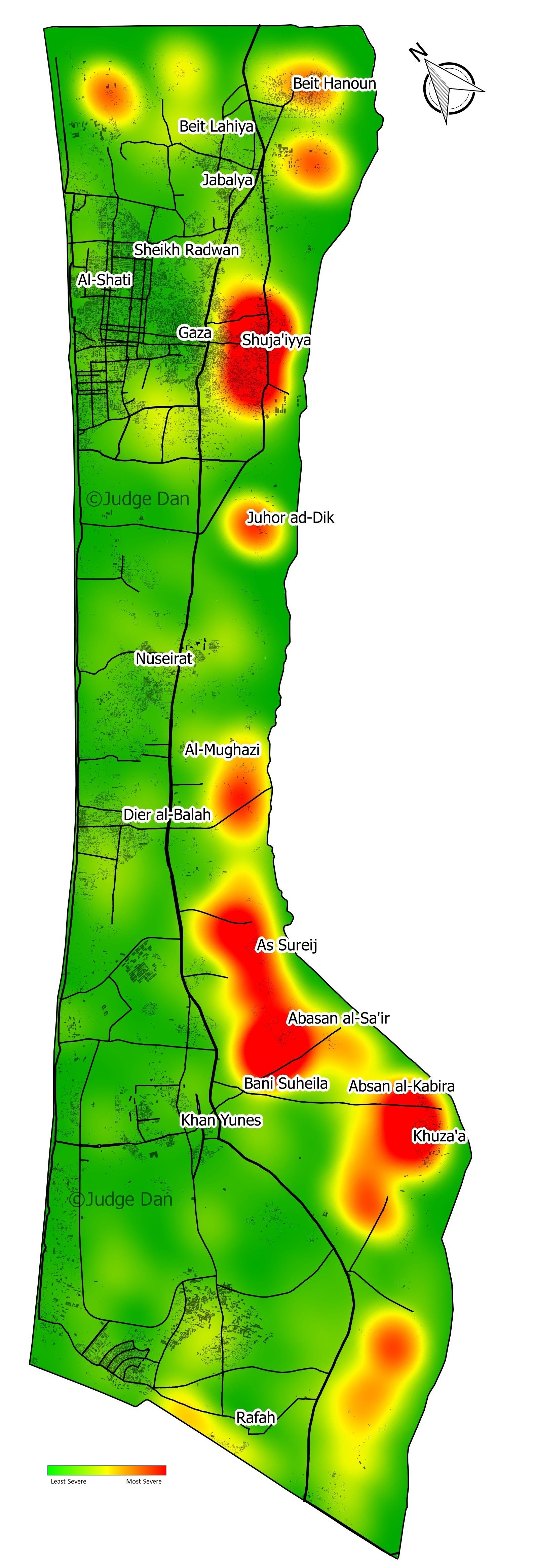
Amnesty International and Forensic Architecture worked with a number of field researchers and photographers who documented sites where incidents took place using protocols for forensic photography. Forensic Architecture located elements of witness testimonies in space and time and plotted the movement of witnesses through a three-dimensional model of urban spaces. It also modelled and animated the testimony of several witnesses, combining spatial information obtained from separate testimonies and other sources in order to reconstruct incidents. Three satellite images of the area, dated 30 July, 1 August and 14 August, were obtained and analysed in detail; the image of 1 August reveals a rare overview of a moment within the conflict. Forensic Architecture also retrieved a large amount of audiovisual material on social media and employed digital maps and models to locate evidence such as oral description, photography, video and satellite imagery in space and time. When audiovisual material from social media came with inadequate metadata, Forensic Architecture used time indicators in the image, such as shadow and smoke plumes analysis, to locate sources in space and time….

Public statements by Israeli army commanders and soldiers after the conflict provide compelling reasons to conclude that some attacks that killed civilians and destroyed homes and property were intentionally carried out and motivated by a desire for revenge – to teach a lesson to, or punish, the population of Rafah for the capture of Lieutenant Goldin.

There is consequently strong evidence that many such attacks in Rafah between 1 and 4 August were serious violations of international humanitarian law and constituted grave breaches of the Fourth Geneva Convention or other war crimes.

It really is worth accessing the full report and closely examining the video animations produced by Forensic Architecture.

Lambert Hannibal Directive JPEG

You can find a commentary on the project and its wider implications, which also draws on a lecture FA’s Eyal Weizman gave at Médecins sans Frontières in Paris earlier this month, by Léopold Lambert over at Warscapes here: ‘The Hannibal Directive and the economy of lives: making sense of Black Friday in Gaza‘.

The Hannibal Directive exists because of the historical asymmetrical characteristics of prisoner exchanges between the Israeli government and Palestinian and Lebanese political groups like Hamas and Hezbollah. The armed sections of these groups evidently rely on this precise asymmetrical relationship and undertake kidnappings of one or multiple Israeli soldiers when possible to negotiate the liberation of several Palestinians held in Israeli prisons. However, the economy of lives that can be perceived through this asymmetry is profoundly disturbing. The hidden message in the enunciation of the 2011 Shalit exchange is the following: One Israeli life is worth 1,027 Palestinian lives. The very fact that many of us know Shalit’s name, but not one of the 1,027 liberated Palestinian prisoners’, is symptomatic. In the case of “Black Friday,” this economy of lives exposes its violence through even more extreme and perverse forms: for the Israeli army, 135 to 200 Palestinian lives are worth ending in order to end an Israeli one, so to avoid freeing Palestinian prisoners.

We should not think of the concept of economy of lives as a retrospective reading of the Israeli Army’s crimes: This logic is at work in most Western military decision making, as Weizman shows in his book The Least of All Possible Evils (Verso 2011) through interviews with Human Rights Watch consultant Marc Garlasco, a former Pentagon “chief of high-value targeting” during the first years of the 2003 US war in Iraq. For each airstrike against an Iraqi political or military figure that Garlasco designed, he had to follow a “correct balance of civilian casualties in relation to the military value of a mission. ” In other words, there is a number of civilians the US army allows itself to kill as “collateral damage” when targeting a strategic assassination. In Iraq, this number was 30, Garlasco reveals. “In this system of calculation,” writes Weizman, “twenty-nine deaths designates a threshold. Above it, in the eyes of the US military lawyers, is potentially ‘unlawful killing’; below it, ‘necessary sacrifice.’” Here, again, lives are disincarnated into statistics calculated in relation to military and ideological objectives.

AI Unlawful and deadly JPEGI should not that there are also important critiques of Amnesty’s other investigations into ‘Operation Protective Edge’, most significantly from Normal Finkelstein at Jadaliyya.  

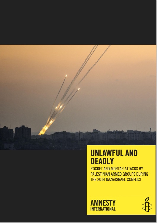
He takes particular exception to Amnesty’s Unlawful and Deadly: Rocket and mortar attacks by Palestinian armed groups during the 2014 Gaza/Israel conflict.

He insists that Amnesty too often cites official Israeli sources in ways that ‘magnify Hamas’s and diminish Israel’s criminal culpability’. You can access what he describes as his ‘forensic analysis’ of that report in two parts, here and here.

My own posts on ‘Operation Protective Edge’ are here, here, here, here, here (my own attempt at a forensic analysis of sorts), and here.

Drone networks

Three contributions to the debates over drones and military violence.  First, my friends at the Bard Center for the Study of the Drone have published Dan Gettinger‘s essay on ‘Drone Geography: mapping a system of intelligence‘.  It’s a superb sketch of the intelligence network in which the US Air Force’s drones are embedded (you can read my complementary take on ‘Drone geographies’ under the DOWNLOADS tab).  Let me add just one map to the illustrations that stud his essay.  It’s taken from the Air Force’s RPA Vector report for 2013-28, published last February, and it shows the architecture of remote split operations within and beyond the United States.  It’s helpful (I hope) because it shows how the Ground Control Stations in the continental United States feed in to the Distributed Common Ground System that provides image analysis and exploitation (shown in the second map, which appears in a different form in Dan’s essay).  I’m having these two maps combined, and I’ll post the result when it’s finished.

RSO architecture (USAF) 1

Distributed Common Ground System (USAF) 2

Dan is right to emphasise the significance of satellite communications; much of the discussion of later modern war and its derivatives has focused on satellite imagery, and I’ve discussed some of its complications in previous posts, but satellite communications materially shape the geography of remote operations.  The Pentagon has become extraordinarily reliant on commercial providers (to such an extent that Obama’s ‘pivot to the Pacific’ may well be affected), and limitations of bandwidth have required full-motion video streams from Predators and Reapers (which are bandwidth hogs) to be compressed and image quality to be degraded.  Steve Graham and I are currently working on a joint essay about these issues.

One caveat: this is not the only network in which US remote operations are embedded.  In my essay on ‘Dirty Dancing’ (now racing towards the finish line) I argue that the CIA-directed program of targeted killing in the Federally Administered Tribal Areas of Pakistan cannot be severed from the multiple ways in which the FATA have been configured as both borderlands and battlefields and, in particular, from the cascade of military operations that have rendered the FATA as a space of exception (in something both more and less than Agamben’s sense of the term).  Here I’ve learned much from an excellent essay by Elizabeth Cullen Dunn and Jason Cons, ‘Aleatory sovereignty and the rule of sensitive spaces’, Antipode 46 (1) (2014) 92-109).  They complicate the claim that spaces of exception always derive from a single locus of sovereign power (or ‘the sovereign decision’).  Instead, they  suggest that borderlands are ‘contested spaces’ where ‘competing’ powers ‘collide’.  In the FATA multiple powers have been involved in the administration of military violence, but on occasion – and crucially – they have done so in concert and their watchword has been a qualified and covert collaboration. In particular, the FATA have been marked by a long and chequered gavotte between the militaries and intelligence services of the United States and Pakistan which, since the 1980s, has consistently put at risk the lives of the people of the borderlands.  And in my essay on ‘Angry Eyes’ (next on my screen) I argue that the US military’s major use of Predators and Reapers in Afghanistan – orchestrating strikes by conventional aircraft and providing close air support to ‘troops in contact’ – depends on communication networks with ground troops in theatre, and that this dispersed geography of militarised vision introduces major uncertainties into the supposedly ‘precise’ targeting process.

CHAMAYOU Theory of the droneSecond: Elliott Prasse-Freeman has an extended review of the English translation of Grégoire Chamayou‘s Theory of the drone – called ‘Droning On‘ – over at the New Inquiry (you can access my own commentaries on the French edition here: scroll down).  His central criticism is this:

While his title promises theory, we instead are treated to a digression on the military and social ethics of attacks from the air, in which Chamayou asks without irony, “can counterinsurgency rise to the level of an aero-policy without losing its soul?” What offends Chamayou is the “elimination, already rampant but here absolutely radicalized, of any immediate relation of reciprocity” in warfare. This, we are told, is the problem.

Promised a theory of the drone, how do we arrive at a theory of the noble soldier?…

And so, dispatching with the dream of the drone … Chamayou assumes the concerns not of the brutalized but of military leaders and soldiers.

He continues in terms that resonate with my argument in ‘Dirty Dancing’:

By combining knowing (intelligence, surveillance, reconnaissance), sighting (targeting in movement and in the moment), and eliminating (“putting warheads on foreheads”), the drone constitutes an assemblage of force (as drone-theorist Derek Gregory puts it) that promises a revolution in control and allows the US war apparatus to imagine space and politics in new ways. Because the body of the accused can ostensibly be precisely seen, it can be seen as itself carving out a body-sized exception to state sovereignty over the territory on which that body moves. In this way, eliminating the body does not constitute an assault on the territory of the state, as these bodies are presented as ontologically (and hence quasi-legally) disconnected from that territory.  Geographer Stuart Elden in Terror and Territory (2009) points out the significant overlap between who are labeled ‘terrorists’ and movements fighting for their own political spaces – which hence necessarily violate extant states’ ‘territories’ (and hence the entire international order of states): to violate territory is to terrorize. The US is hence remarkably concerned in its arrogation of a position of supra-sovereignty to ensure that it overlaps with ‘classic’ state sovereignty, and by no means violates the norm of territorial integrity (well-defined borders): by harboring or potentially harboring unacceptable transnational desires, the militant uproots himself, and risks being plucked out and vaporized in open space that belongs only to him. The exception to sovereignty provides the drone the opportunity to extend this exception into temporal indefiniteness: wars are not declared, aggressions are not announced—the fleet, fusing police and military functions, merely watches and strikes, constantly pruning the ground of human weeds.

In ‘Dirty Dancing’ I’m trying to prise apart – analytically, at least – the space of exception, conceived as one in which a particular group of people is knowingly and deliberately exposed to death through the political-juridical removal of legal protections and affordances that would otherwise be available to them, and territory conceived (as Stuart suggests) as a political-juridical technology, a series of calculative practices that seeks to calibrate and register a claim over bodies-in-spaces.  That’s why Dan Gettinger’s essay is so timely too, and why I’ve been thinking about the FATA as a performance of what Rob Kitchin and Martin Dodge call ‘code/space’, why I’ve been working my way through the files released by Edward Snowden, and why I’ve been thinking so much about Louise Amoore‘s superb critique of The politics of possibility: risk and security beyond probability (2013).

Screen Shot 2015-01-07 at 10.03.16 AM

Although Louise doesn’t address drone strikes directly, her arguments are full of vital insights into the networks that are mobilised through them.  ‘The sovereign strike is always something more, something in excess of a single flash of decision’, she insists, and when she writes that —

those at risk (which is to say those who are to be put at risk by virtue of their inferred riskiness) are ‘not strictly “included by means of their own exclusion”, as Agamben frames the exception, they are more accurately included by means of a dividuated and mobile drawing of risk fault lines’

17— it’s a very short journey back to Grégoire Chamayou‘s reflections on the strange (in)dividual whose ‘schematic body’ emerges on the targeting screen of the Predator or Reaper.  Louise writes of ‘the appearance of an emergent subject’, which is a wonderfully resonant way of capturing the performative practices through which targets are produced: ‘pixelated people’, she calls them, that emerge on screens scanning databanks but which also appear in the crosshairs…

And finally, Corporate Watch has just published a report by Therezia Cooper and Tom Anderson, Gaza: life beneath the drones.  This brings together a series of interviews conducted in 2012 – when ‘drones killed more people in Gaza than any other aircraft’ – that were first published in serial form in 2014.  The report includes a tabulation of deaths from Israeli military action in Gaza and those killed directly by drones (2000-2014) and a profile of some of the companies involved in Israel’s military-industrial complex.

Overlooking Auschwitz

To mark the 70th anniversary of the liberation of Auschwitz-Birkenau concentration camp, there has been widespread interest in a haunting video shot for the BBC using a commercial drone:

For once, the emptiness of the scene – just buildings, fences and railway tracks – is desperately affecting.   It’s surely impossible to watch this without thinking of the millions of people whose lives were so brutally effaced by the murderous regime of the Third Reich.  The only sign of a human presence in the video is a glimpse over the wall of trucks racing by: a reminder that Auschwitz was (and disconcertingly remains) at the centre of a small town (see also my post on Auschwitz here).

There are at least two other films that ought to be seen too.

Night Will Fall 2

The first is a documentary commissioned in 1945 by the Psychological Warfare Film Section of the Supreme Headquarters Allied Expeditionary Force to document the liberation of Bergen-Belsen.  The producer was Sidney Bernstein, for Britain’s Ministry of Information; Alfred Hitchcock was drafted in as a ‘treatment adviser’.  The working title was German Concentration Camps: Factual Survey; it was never shown in its entirety (though Billy Wilder turned the footage into a short, Death Mills), and the Imperial War Museum notes:

From the start of the project, there were a number of problems including the practical difficulties of international co-operation and the realities of post-war shortages. These issues delayed the film long enough to be overtaken by other events including the completion of two other presentations of concentration camp footage to the German people and the evolution of occupation policy, where the authorities no longer considered a one-hour compilation of atrocity material appropriate. The last official action on the film was a screening of an incomplete rough-cut on 29 September 1945, after which the film was shelved, unfinished.

The footage has now been incorporated into a stunning HBO documentary, Night Will Fall, directed by André Singer, who was an Executive Producer for Act of Killing (see my posts here, here and here).

NIGHT-WILL-FALL-POSTER-2

There are all sorts of stories about why the full version was never shown – see the Guardian‘s report here – but the fullest discussions are Kay Gladstone‘s ‘Separate intentions’ in Toby Haggith and Joanna Newman (eds) Holocaust and the moving image (2005) (see also Haggith’s ‘Filming the liberation of Bergen-Belsen here) and her ‘Memory of the Camps: the rescue of an abandoned film’, in Griselda Pollock and Max Silverman (eds) Concentrationary cinema (2011).

The second film returns to the aerial view and to Auschwitz: Harun Farocki’s Images of the world and the Inscription of War.  Shockingly and sadly, Farocki died last summer at the age of 70, and Images is widely regarded as his masterpiece (see Thomas Voltzenlogel‘s wide-ranging and appreciative discussion of ‘Dialectics in images’ here).  The central motif is an image taken from a series of aerial photographs of Auschwitz shot by the Allies between April 1944 and January 1945 (see also here and here).

1389.3 Holocaust E

This image was taken on 4 April 1944 by Lt Charles Barry flying a Mosquito from 60 Photo Reconnaissance Squadron of the South African Air Force.  From the film’s commentary [available in Discourse 5(3) (1993) 78-92]:

American aircraft had taken off in Foggia, Italy, and flown towards targets in Silesia – factories for synthetic petrol and rubber – known as Buna.

On the flightover the IG Farben company factory still under construction, a pilot clicked his camera shutter and took photographs of the Auschwitz concentration camp.

First picture of Auschwitz taken at 7,000 meters altitude.

The pictures taken in April 1944 in Silesia arrived for evaluation in Medmenham, England [the RAF’s Central Intelligence Unit concerned with air photograph interpretation].

The analysts discovered a power station, a carbide factory, a factory under construction for Buna and another for petrol hydrogenation.

They were not under orders to look for the Auschwitz camp, and thus they did not find it.

How close the one is to the other: the industry – the camp.

It was not until 1977 that two employees of the CIA [Dino Brugioni and Robert Poirer: see their detailed report here] went through the archives to find and evaluate the photographs of Auschwitz. It was not until thirty-three years later that the following words were inscribed:

Tower and Commandant’s house and

Registration Building and Headquarters and Administration and

Fence and execution wall and Block 11 and the word “Gas chamber” was inscribed.

tumblr_n6e9sd1riY1rxmv4io1_500

Kaja Silverman adds this gloss [‘What is a camera?’ Discourse 5 (30 (1993) 3-56]:

Not only does the camera here manifestly “apprehend” what the human eye cannot, but the latter seems strikingly handicapped by its historical and institutional placement, as if to suggest that military control attempts to extend beyond behavior, speech, dress,and bodily posture to the very sensory organs themselves. This sequence indicates, in other words,that military discipline and the logic of warfare function to hyperbolize the distance separating look from gaze and to subordinate the former completely to the latter.

These are similar issues that haunt my own discussions of the video feeds from Predators and Reapers over Afghanistan and Iraq.  In another commentary, Christa Blümingler writes:

The vanishing point of Images of The World is the conceptual image of the ‘blind spot’ of the evaluators of aerial footage of the IG Farben industrial plant taken by the Americans in 1944. Commentaries and notes on the photographs show that it was only decades later that the CIA noticed what the Allies hadn’t wanted to see [my emphasis]: that the Auschwitz concentration camp is depicted next to the industrial bombing target.

Bombing of AuschwitzThe claim that the ‘Allies didn’t want to see’ spirals through an important debate about whether the Allies could or should have bombed Auschwitz (see, in addition to the symposium on the right, here and here).  In fact, as Christa observes later,

In … 1944, the allies bombed not Auschwitz, but the IG Farben factory nearby the death camp. Drawing on analyses of these events, how and why the allies didn’t act on their knowledge of the mass destruction of the Jews, Farocki … decodes a host of military images, focusing on two visual dispositives: American pilots in 1944 and CIA agents in 1977 offering two different [readings] of the aerial photographs of Auschwitz.

In this instance, Farocki developed an epistemological field of technological history — measurement and surveillance in a period of rapid automatization. At the end of the film, a blind spot in the photographic act, referring back to the reality of the concentration camp, becomes visible.

The final shots further emphasize details of the American pilots’ aerial photos, which are picked up in the sweep of the film several times, framed and arranged in different ways. At the end of the film, through a permutative movement of cuts, the extreme enlargement of the photographs reminds us once again of their materiality. Farocki shows these images in precisely the spaces where visual thought takes place, and in connection to specific techniques of reproduction and distribution (in albums, archives, institutions). Whenever he used marginal and hard-to-access image materials from specialized archives, he sought to consider these conditions of visibility in his analysis.

Farocki2

What particularly interests me, and the reason I juxtapose these two films, is an interview with Chris Darke in 2003 in which Farocki artfully tracks between the eye-witness and the aerial shot:

Chris Darke: In Images of the World and the Inscription of War there is this repeated phrase: “Beside the real world there is a second world, a world of pure military fiction”. I was very strongly reminded of Colin Powell at the UN Security Council presenting degraded military surveillance images as proof and justification for military action.

HF: Yes, it reminded me so much of the Auschwitz sequences in Images of the World, the way they involved aerial reconnaissance images that you had to be a specialist to read. Who knows what they are telling you? Who knows what happened there? What is so interesting is that the personal witness of two people who had escaped from the camps was so important. It was the way that traditional history was always written. You need an eye-witness, a narrative, otherwise you’ll never believe in it. And it turns out that our imaginative minds are still very old-fashioned. We don’t understand modernist strategies such as those used by the Americans in the first Gulf War. You really want to see these terrible, dirty images of burning streets and wounded people in the same way that psychoanalysis knows that you need dirty thoughts for the imagination, just as for love you need dirty images. The audience is not prepared for this automatically recorded history that more or less happens already, where everything is recorded; so there has to be an old-fashioned drama made out of it.

There are at least two other detailed commentaries on the film that address the question of visuality in depth: Thomas Keenan‘s ‘Light weapons’, in Documents 1/2 (1992) 147-58 and Nora Alter‘s ‘The political im/perceptible in the essay film:  Farocki’s Images of the world and the inscription of war‘, in New German Critique 68 (1996). More generally, I also recommend the special issue of e-flux on Farocki’s work here, including a commentary by Trevor Paglen on Farocki’s ‘operative images’, and David Cox‘s brief commentary here.

Note:  Belinda Gomez writes (in relation to the commentary for Images of the World):

“Fence and execution wall and Block 11 and the word “Gas chamber” was inscribed….” But that’s not quite accurate. Brugioni and Poirier didn’t write that in 1977. The gas chamber didn’t have a sign. That they were able to locate the gas chamber and crematoria was due to their superior technology and they knew what they were looking for. The pilot/photographers in 1944 took photos of the factory and what was taken as a workers camp. To say that they didn’t see Auschwitz because they weren’t told to look for it is more of a hind-sight interpretation.

Torture and raison d’état

statue-of-liberty-waterboardingMelanie Richter-Montpetit has an essay at The disorder of things, ‘Why Torture When Torture Does Not Work? Orientalism, Anti-Blackness and the Persistence of White Terror‘, which repays careful reading.

[L]ocating the findings of the Senate Torture Report within the racial-sexual grammars of chattel slavery and its afterlife opens up our analyses beyond explanatory and moral frameworks such as failed intelligence-gathering, “state of exception” or “human rights abuses” towards a more comprehensive understanding of seemingly illiberal security practices in the War on Terror. This genealogy indicates the fundamental role and value of force for the consolidation of the sovereign authority of the U.S. settler imperial formation ‘at home’ and abroad, and suggests the stubborn persistence of certain racial-sexual grammars of legitimate violence and suffering in this age of “post-racial triumph.” For “[w]ithout the capacity to inspire terror, whiteness no longer signifies the right to dominate.”

The immediate provocation for her essay, which is rooted in her recent York PhD thesis Beyond the Erotics of Orientalism: Homeland Security, Liberal War and the Pacification of the Global Frontier, was the Senate Torture Report (see my earlier post on ‘Tortured geographies’ here).

GTMO Statue of LibertyAt Just Security Jameel Jaffer has a brief, important post about the release of these documents – and, crucially, the Obama administration’s attempt to prevent the publication of photographs documenting the abuse of detainees at US military facilities – that loops back to the debate over the Charlie Hebdo cartoons.  He argues that it is at the very least ironic that some of the same voices calling for the freedom to publish cartoons whatever their consequences are now demanding the suppression of other images ‘because of the possibility that their release will provoke violence’…

And speaking of violence and torture in the global war prison, Mohamedou Ould Slahi‘s Guantanamo Diary, which is being serialised in the Guardian and was published in book form earlier this week, provides more evidence of its routinised, banalised practice.

Slahi Unclassified Manuscript scan

Slahi is still incarcerated at Guantanamo even though he was approved for release in 2010.  Spencer Ackerman reports:

Slahi’s manuscript was subjected to more than 2,500 redactions before declassification, ostensibly to protect classified information, but with the effect of preventing readers from learning the full story of his ordeal. The book is being published with all the censor’s marks in place, and the publishers – Canongate in the UK and Little, Brown in the US – hope they will be able to publish an uncensored edition when Slahi is eventually released.

The full manuscript is available here.  You can find Tim Stanley‘s review at the Telegraph here (‘a necessary book’ that ‘reminds us that the evil we’re fighting can be found in ourselves as well as in our enemies’), Mark Danner‘s extended review at the New York Times here (‘Slahi’s memoirs are filled with numbingly absurd exchanges that could have been lifted whole cloth from “The Trial”’), and Deborah Perlstein‘s review at the Washington Post here (‘Slahi’s descriptions of … torture are the book’s most compelling, and difficult, passages [and] … are closely consistent with descriptions in official investigations of the treatment of other U.S.-held detainees’.)

In the face of these horrors, it’s necessary to consider this blunt reminder from Peter Beinart:

Torture, declared President Obama … in response to the newly released Senate report on CIA interrogation, is “contrary to who we are.” Maine Senator Angus King added that, “This is not America. This is not who we are.” According to Kentucky Congressman John Yarmuth, “We are better than this.”

No, actually, we’re not. There’s something bizarre about responding to a 600-page document detailing systematic U.S. government torture by declaring that the real America—the one with good values—does not torture. It’s exoneration masquerading as outrage. Imagine someone beating you up and then, when confronted with the evidence, declaring that “I’m not really like that” or “that wasn’t the real me.” Your response is likely to be some variant of: “It sure as hell seemed like you when your fist was slamming into my nose.” A country, like a person, is what it does.

And in the face of evasion and denial – and redaction and suppression – here is Chase Madar from February’s Bookforum:

Though the [Senate] report has blacked out the names of the torturers, refusing even to use pseudonyms, torture watchers have been able to identify one of the agents, a model for Maya in Zero Dark Thirty. Her record of malfeasance, misrepresentation, incompetence, and gratuitous participation in waterboarding was blisteringly detailed by NBC News and [Jane Mayer at] the New Yorker, though neither outlet would name her. But far from being sanctioned or even demoted, she has risen to the civilian-rank equivalent of general inside the CIA. She has, unbelievably, served as the recent head of the agency’s “global jihad unit.”

It’s tempting to compare this to Latin American–style police impunity, but that would be unfair to the societies that have punished at least some of the abuses of their past dictatorships. In the same week that the SSCI released its report, Brazil published its own investigation into state torture of political dissidents under its long dictatorship. Indeed, one of that torture regime’s victims, Dilma Rousseff, is now the head of state. Latin American nations have been chipping away at, or simply ignoring, the amnesty deals made with the authoritarian rulers of the ’70s and ’80s and have brought many of their torturers to justice.

The United States would face a very different reckoning with its record of torture, should it elect to take a genuine, closer look at it. In our case, the impact of torture has largely been muffled by the military adventurism that has underwritten it…

Kill Chain

COCKBURN Kill chain 1

Yet more on targeted killing/assassination: new from Verso and Henry Holt in March, Andrew Cockburn‘s Kill Chain: the rise of the high-tech assassins.

Kill Chain uncovers the real and extraordinary story of drone warfare, its origins in long-buried secret programs, the breakthroughs that made drone operations possible, the ways in which the technology works, and, despite official claims, does not work. Through the well-guarded world of national security, the book reveals the powerful interests—military, CIA, and corporate—that have led the drive to kill individuals by remote control. Most importantly of all, the book describes what has really happened when the theories underpinning the strategy—and the multi billion-dollar contracts they spawn—have been put to the test.

Andrew is the author of the brilliant Rumsfeld: an American disaster, and he’s also been writing around the issue of military and paramilitary violence for some time.  There’s an early review of Kill Chain from Kirkus here, and Andrew discusses writing the book in a short audio clip here.

If you can’t wait until March, there’s a taster in ‘Drones, baby, drones‘, which appeared in the London Review of Books (8 March 2012); if you aren’t a subscriber you can obtain 24-hour access free of charge.

Time and again, the military has claimed that advances in technology have finally made warfare predictable and precise. That was the promise of Igloo White in Vietnam [see my ‘Lines of descent’: DOWNLOADS tab], the video-game spectacle of the Gulf War, the war for Kosovo and the counter-guerrilla wars of the past ten years. Time and again, the military’s claims have been disproved. Will drones change everything? Robert Gates, secretary of defence from 2006 to 2011, expressed the official view in his address to the CIA Officers Memorial Foundation annual dinner last March. Confessing that he hadn’t initially done enough to quash resistance to innovation from ‘flyboys in silk scarves’, Gates said: ‘From now on, it’s drones, baby, drones.’

In the audio clip Andrew insists that the full-motion video feeds from Predators and Reapers are far less clear than most commentators make out, and in subsequent contributions Andrew has perceptively linked the fantasies of the God-trick with militarized vision more generally: see, for example, his ‘Tunnel vision‘ (about the comparative merits of the A10 and the B1 bomber) which appeared in Harper’s in February 2014 and ‘Flying Blind‘, which appeared on Harper’s blog in September.

I’m not convinced that the A-10 is able to ‘observe the battleground with such precision, and safely to target enemy forces a stone’s throw away from friendly troops’ as Andrew maintains, but his more general point is a sharp one.  Too often we forget that other aircraft rely on optical sensors and video screens too, not only Predators and Reapers, and that these political technologies differ from platform to platform, as the following slides from ‘Angry eyes’ indicate (where the captain of an AC-130 gunship in fact defers to the crew of a Predator):

Angry eyes VISION.001

Angry eyes VISION.002

And, as Andrew also makes clear, these technologies produce their own interpellations:

Video will often supply a false clarity to preconceived notions. One A-10 pilot described to me an afternoon he spent circling high over southern A ghanistan in May 2010, watching four people—tiny figures on his cockpit screen—clustering at the side of a road before they retreated across a field to- ward a house. Everything about their movements suggested a Taliban I.E.D.- laying team. Then the door to the house opened and a mother emerged to hustle her children in to supper.

“On the screen,” he explained, “the only way to tell a child from an adult is when they are standing next to each other. Otherwise everyone looks the same.”

“We call the screens face magnets,” remarked another veteran, Lieutenant Colonel Billy Smith, a former A-10 squadron commander who flew tours over Bosnia, Iraq, and Afghanistan. “They tend to suck your face into the cockpit, so you don’t pay attention to what’s going on outside.”

All of this intersects with my continuing work on militarized vision, and in the next several weeks I’ll be uploading a series of new essays that deal with drone strikes in Pakistan [based on my ‘Dirty dancing‘ presentations], the Sangin Valley in Afghanistan (a ‘friendly fire’ incident), and an air strike in Uruzgan in Afghanistan that was orchestrated by a drone [based on my ‘Angry Eyes’ presentations]. So watch this space…

Incidentally, ‘kill chain’ is both the extended, networked apparatus that leads from air targeting to execution – for all platforms, remote and conventional – and the injunction that is typed into US military chat rooms (mIRC) to close down ‘chatter’ that might distract pilots once they are cleared to engage (see my discussion here).

Under American Skies

I’ll be in Berlin in December for a conversation with James Bridle about drone wars and related issues, and I’m already looking forward to it since I’m a great admirer of his work. I particularly admire the way in which he challenges so many of our assumptions about ‘looking’ through his presentations about militarised vision and violence, and I’ve noted before the filiations between his various projects and Josh Begley‘s.

Tomas van HoutryveSo I was interested to read about photographer Tomas van Houtryves (right) project Blue Sky Days.  He begins with an arresting observation with which both James and Josh would be only too familiar:

‘Although a huge amount of [full motion video] footage has been collected [by US drones], the program is classified, and few people have ever seen images of the drone war and its casualties. This seems like a paradox in our thoroughly media-connected age. How can America be involved in a decade-long war where the sky is buzzing with cameras, and yet the public remains totally in the dark?’

But his response to the question is distinctly different: he repatriates the drone wars from Pakistan to the United States (here the most appropriate comparison is with Omar Fast‘s 5,000 Feet is the Best).

Tomas van Houtryve 1

To do so, Tomas travelled across America with a small quadcopter drone bought from Amazon.com attached to his camera.  His concept was simple, Rena Silverman explains in the New York Times:

Take the idea of foreign drone strikes and instead target similar domestic situations, putting them under surveillance using his drone in public spaces. He made a list of hundreds of different strike reports, gleaning as many details about the circumstances…

He rented a black car with tinted windows and placed himself, his drones, his batteries and lists in the car. He spent six weeks in late 2013 averaging between seven and 10 drone flights daily, sleeping in a different town every night. He would pull the car into an empty lot, get out, launch the drone for about five to 10 minutes — about as long as its power lasted — take footage, land the drone, drive away and recharge the batteries while en route to the next location…

He followed his list carefully, trying to imitate “signature strikes,” referring to a May 2012 New York Times article in which some State Department officials complained about the lax criteria for identifying a terrorist “signature.” The joke was that “three guys doing jumping jacks” could be enough suspicious activity for the C.I.A. to conclude it could be a terrorist training camp. In other words, targeting people based on behavior rather than identity.

Tomas van Houtryve 2 copy

He photographed people exercising in Philadelphia, their shadows long and pinned against the grid of a park. He noticed more “signature” behavior while driving through San Francisco, where he encountered a group doing yoga [above]. When Mr. van Houtryve recently printed the image, he asked viewers if they thought the subjects were praying or exercising. It was a toss-up.

Although these images are not quite ‘what drone attacks in America would look like’, as Pete Brook suggested in WIRED – Tomas’s drone was flying much lower (‘only about six stories high’) and these images are pin-point sharp: there’s none of the ambiguity of infra-red heat signatures here – none the less that last sentence really says it all.  Images do not speak for themselves and interpretation counts for everything – which is why, as I’ve repeatedly argued, it matters so much what pilots, sensor operators and image analysts are pre-disposed to see.

It turns out that a particular incident provoked Tomas’s project – the murder of Mamana Bibi at Ghunda Kala in North Waziristan on 24 October 2012, which I described here –  and also gives it its title.

Zubair RehmanIn October 2012, a drone strike in northeast Pakistan killed a 67-year-old woman picking okra outside her house. At a briefing held in 2013 in Washington, DC, the woman’s 13-year-old grandson, Zubair Rehman, spoke to a group of five lawmakers. “I no longer love blue skies,” said Rehman, who was injured by shrapnel in the attack. “In fact, I now prefer gray skies. The drones do not fly when the skies are gray.”

There’s more from Tomas at Harper’s here, which originally co-sponsored the project with the Pulitzer Center, and you can see more of his drone’s eye view images at the National Geographic here.

There’s also a revealing interview conducted by Bard College’s Center for the Study of the Drone here; it contains all sorts of interesting observations, but one in particular resonated.  Asked about the tension between the beauty of his photographic compositions and the horror of what he is seeking to convey, Tomas says this:

‘The base subject that I’m trying to raise awareness about and get people to think about in less abstract terms is the foreign drone war. If you take the time to read through the particular airstrikes, a lot of them are quite horrifying. But on the other hand, as a photographer, I know that beauty is one of the tools that we use to get people to look at a picture. Beauty has a lot of power, so there’s a tension between trying to seduce people with the language of photography, which is beautiful composition, and trying to reveal something that might be uncomfortable or difficult to digest, once people fully grasp it.’

Another of my art icons, elin o’Hara slavick, says something very similar about her mesmerising sequence of aerial images of places bombed by the US, Bomb after bomb (see also Brian Howe‘s discussion here and my own in ‘Doors in to Nowhere’ [DOWNLOADS tab], from which I’ve taken this passage):

‘She adopts an aerial view—the position of the bombers—in order to stage and to subvert the power of aerial mastery. The drawings are made beautiful “to seduce the viewer,” she says, to draw them into the deadly embrace of the image only to have their pleasure disrupted when they take a closer look. “Like an Impressionist or Pointillist painting,” slavick explains, “I wish for the viewer to be captured by the colors and lost in the patterns and then to have their optical pleasure interrupted by the very real dots or bombs that make up the painting.”’

A tart reminder that there are multiple ways of ‘just looking‘.

Predator View

I’m in Zurich – many thanks to Benedikt Korf for the invitation and the wonderful hospitality – for a seminar with Benedikt’s doctoral students on the long form version of ‘The Natures of War’ (they have what I hope is the penultimate draft; I’ll post the final version once I’ve reworked it after the seminar) and then a public lecture: ‘Angry eyes: the militarization of vision and modern war’.

Part of my argument in the lecture is about the narrowness of ‘Predator View’, so let me explain what I mean.  My starting point is the illusion that the use of the intelligence, surveillance and reconnaissance capabilities of remote platforms like the MQ-1 Predator or the MQ-9 Reaper produces a transparent battlespace: in effect, a version of Donna Haraway‘s ‘God-trick’, the ability to see everything from nowhere in particular.  The most succinct version of this is the treatment of laser targeting as ‘the eye of God’:

Eye of God.001

In fact, ‘Predator View’ is remarkably narrow. First, and most directly, a common complaint is that the view provided by its Full Motion Video is literally too narrow – ‘like looking through a soda straw’.  It’s for this reason that pilots and sensor operators also use FalconView, a Windows-based mapping tool that is supposed to provide them with situational awareness.  I’ve taken the image below from a presentation by Lt Col Paul Hastert (USAF) on ‘Spiral development in wartime’ – the screenshot is the FalconView image, the small square the field of view from a Predator – but the most detailed account of FalconView is Jon Lindsay‘s ‘”War upon the map”‘: User innovation in American military software’, Technology and culture 51 (3) (2010) 619-51.

FALCONVIEW and Predator FOV

There have been several later releases of FalconView, and a version is now even open source, so it’s probably not surprising that the US military also uses Google Earth.  In fact, in two of the air strikes I consider in detail it was, in part, juggling these different views that contributed to wrong targeting decisions.  (There are projects that provide a wider field of view – the nine-camera suite of Gorgon Stare is in operation and its second increment is already in use in Afghanistan – and others that integrate imagery from multiple sources, like Raytheon’s Zeus, which is intended to supplant FalconView as the ‘primary mission execution tool‘).

But in the air strikes that I consider those involved in these networked operations are also busy communicating via radio and – crucially – via the typed messages displayed in mIRC‘s online chat windows.  The image below is taken from the US military’s multi-service manual on Tactical Chat (see also the discussion at Public Intelligence here).

mIRC 3 chatrooms

In the case of the ‘friendly fire’ incident in the Sangin Valley in 2011, the pilot and sensor operator were unaware of crucial entries made by image analysts in mIRC and of private (or ‘whisper’) chats to the Mission Intelligence Co-ordiator.  That’s not entirely surprising.  Once permission has been given to engage a target, ‘KILL CHAIN” is typed into the room to minimise extraneous chatter that might otherwise visually distract and so ‘degrade’ the strike.  According to the Mission Intelligence Controller for the Sangin incident:

‘When we got a standby for a 9-line [strike briefing] we put [KILLCHAIN] in the mIRC room to shut down chatter so we can be heads down supporting the pilot and the sensor … as they are getting ready for a possible Hellfire shot our whatever action… That’s our job, to be their third set of eyes…’

That third set of eyes is vital, though of little use if its responses are shut down.  In this case the pilot was paying no attention to mIRC because he was fully occupied:

‘I did not see the chat in the main mission room after seeing muzzle flashes. From that point on, my focus was clear concise communications with the [Joint Terminal Attack Controller] and ensuing [Close Air Support] comms, 9 line etc. At this point I was also focused on keeping the aircraft in position to maintain FMV on the individuals. I was also getting the aircraft into the [Weapons Engagement Zone]. Winds were 30 knots out of the west so I had to make sure I kept the aircraft position and direction in cross check.’

All of this suggests that it is unduly narrow to focus the analytical gaze on the Full Motion Video feeds.

But there’s more.  Militarised vision is not limited to Predators and their successors, and it’s important to consider the clarity and resolution of the imagery captured and transmitted from other, conventional aircraft like the AC-130 (first image below), the B-1 bomber, F-15E strike aircraft or attack helicopters (second image below)  – again, this was important in two of the strikes I consider in detail.

AC-10 Uruzgan.001

MMS from attack helicopter - Uruzgan.001

This leads me to two other senses in which the critical emphasis on ‘Predator View’ is too narrow.  It’s a mistake to fasten on one incident – even what has become the iconic ‘signature strike’ coordinated by a Predator on three civilian trucks in Uruzgan – because that misses the continuities, repetitions and transformations in Close Air Support (which is where most of the mistakes are made).

Better, I think, to widen the analytical gaze, which is why I examine the Kunduz air strike on 4 September 2009 (in which no remote platform was involved), the Uruzgan air strike of 21 February 2010 (which was co-ordinated by a Predator but carried out by two attack helicopters), and the Sangin Valley air strike of 6 April 2011 (which was executed by a Predator).  The Granai strike is included because it trigged McChrystal’s Tactical Directive of 6 July 2009 to minimise civilian casualties: ‘‘We must avoid the trap of winning tactical victories – but suffering strategic defeats – by causing civilian casualties or excessive damage and thus alienating the people.’  In all three cases I’ve worked through thousands of pages of official investigations – one by the German Bundestag since the ISAF report remains classified (Kunduz), and the others by the US Army and US Air Force (Uruzgan) and the US Marine Corps (Sangin Valley).

4 US air strikes in Afghanistan.001

And finally, it is also necessary to consider the multiple viewing positions involved in networked military violence.  There is a de-centralised, distributed and dispersed geography of militarised vision whose fields of view expand, contract and even close at different locations engaged in the administration of military violence.  And in all three incidents it turns out that vital mistakes in the interpretation of imagery were made at operations centres in theatre on the ground.

This has prompted me to radically revise the argument I originally set out in ‘From a view to a kill’ (DOWNLOADS tab).  There my focus was on the geography shown in the first map below – like every other commentator I’ve read, incidentally – but I’ve now widened the angle to take in the geography shown in the second map and this substantially changes the story.

Dispersed vision Uruzgan (1).001

Dispersed vision Uruzgan (2).001

It was what happened at the operations centres at Special Operations Task Force 12 in Kandahar and Combined Joint Special Operations Task Force in Bagram that turned out to be every bit as important as the Predator crew’s obvious desire to ‘go kinetic’.

I make similar arguments about Kunduz, where the F-15E pilots were clearly reluctant to strike and the ground commander and JTAC at the Forward Operating Base overrode their objections.

Sangin is even more instructive, because the official investigation of this ‘friendly fire’ incident that resulted in the deaths of two Marines largely exonerated both the Predator crew and the ground commander and JTAC at the operations centre – but a detailed, spirited counter-memorandum from the US Marines commandant refuted the findings line by line, castigated the attempt to pin the blame for what happened on the young, inexperienced lieutenant leading the patrol, and excoriated the ground commander and JTAC back at the patrol base.  More on this soon.

The (long!) essay on these  strikes is the last chapter I need to complete for The everywhere war. There is a strong sense, so I shall argue, in which it was the view ‘on the ground’ that mattered much more than any ‘light of God’ from above.  And as for transparency….

Inhumanitarian mapping

It’s strange how things sometimes come together – or collide and crash.  Two weeks ago I wrote about satellite imagery and ‘remote violence’, and over the summer I discussed several projects that mapped Israel’s military assault on Gaza and its people,  including the Gaza Crisis Atlas produced by the UN’s Office for the Coordination of Humanitarian Affairs (which makes extensive use of hi-res satellite imagery).

The links between those two posts are obvious enough, but today I have something altogether different in my sights.  ‘Judge Dan’ (Dan Smith), who blogs for Israellycool, has used the Gaza Crisis Atlas to construct a series of maps to geo-wash Israel’s military campaign.

Working from the data in the Atlas, Smith produces four maps to disaggregate the severity of destruction (the four levels, increasing from left to right, are based on OCHA’s own assessment):

DAN SMITH Gaza-Damage-Points-Vertical-All

His conclusions from this exercise are the following:

The attacks are in no way “random” or “indiscriminate”. One can clearly see the spatial distribution of the damage in several aspects. We find 8,952 of the 12,433 total points (72%) are within a 3 KM buffer abutting the border with Israel. The main objective of Operation Protective Edge was to find and destroy dozens of terror tunnels dug from Gaza into Israel.

That the most intensive damage was caused to the area where the tunnels naturally originated is thus perfectly understandable. Furthermore, of the 4,441 destroyed structures, 3,481 of them (78%) are within the 3 KM buffer, as are 2,531 of 3,303 (77%) of the lowest intensity damage (simple craters), which are mostly strikes on rocket launchers and tunnels.

Most of the attacks are grouped around certain neighborhoods or villages, such as Shuja’iyya, Johur ad-Dik, Sureij, and Khuza’a. These were probably the result of the ground operations that took place in dense urban areas also within the 3 KM buffer that housed multiple tunnel entrances and shafts, as well as launch sites for mortars and rockets.

Smith then takes the Israeli military’s map of ‘terrorist infrastructure’ in Shuja’iya and overlays this on what he calls ‘OCHA’s damage points’: ‘the correlation is uncanny.’

Smith’s next manoeuvre is to sweep aside OCHA’s focus ‘on the civilian aspect’ because it ‘misses the big picture’ (really – or perhaps Israelly): ‘the overall intensity of the strikes’.  So he constructs a kernel density map or a ‘damage intensity heat map’:

It now becomes very clear that most of the damage was caused to 5 locations right on the border with Israel. The rest of the Gaza Strip was, for the most part, undamaged. The main population areas of Gaza city, Jabaliya, Khan Yunes, Rafah and Deir el-Balah were disproportionately undamaged (sic).

DAN SMITH Gaza-Damage-Heatmap-Vertical2

He continues:

If we do a rough estimate of the damage area, it is once again clear the vast majority of the Gaza Strip was unscathed. With a fairly generous estimation that a damage point has a 25 meter radius – the footprint of a house, or the blast radius of a bomb – the total damage area of the 12,433 impacts was in the order of 15 KM2. The land area of the Gaza strip is 360 Km2. In other words, less than 5% of the land was affected.

There’s a follow-up post on ‘damage clusters’ here, but in this commentary I’ll focus on Smith’s ‘big picture’.  I take the basic points to be these:

(1)  Smith’s approach makes an appeal to the supposed objectivity and even facticity of the map (and, by extension, the satellite image), but there is a substantial body of scholarship that goes back 25 years and underscores the multiple ways in which mapping is an exercise in the production of power.  For a depressingly relevant example of the ways in which maps can speak power to truth, taken from Israel’s attack on Gaza in November 2012, see my discussion here (scroll down to the maps).

(2)  Appealing to the map and its manipulations as the single source of authority is designed to disavow the testimony of witnesses on the ground: precisely the point sharpened by Andrew Herscher in his timely critique of ‘Surveillant witnessing’ (see my discussion here) and a far cry from the incorporation of photographs in (say) the Gaza War Map.

(3) Smith’s methodology reduces Gaza to an object space of structures and buildings, craters and points; he constructs a kernel density map (more on this in a moment) but provides no population density map that would at least gesture towards the people killed, wounded and traumatised by the Israeli offensive and who are wholly absent from his account.  Here, by contrast, is a map I posted previously showing deaths in Gaza to 6 August:

w6401

The Gaza Crisis Atlas focuses on damage to buildings and infrastructure because it is a tool directed explicitly towards reconstruction, so the same criticism doesn’t apply (particularly if you look at OCHA’s work more generally, including the information it provided for the map I’ve just reproduced). But if we are to limit ourselves to gazing on structures from space, UNOSAT’s analysis of satellite imagery provides a sharp reminder that these buildings included schools and hospitals (see also here and here); the report also provides a telling comparison between the intensity of destruction in 2009 and 2014:

UNOSAT_GAZA_REPORT_OCT2014_WEB (dragged)

(4) Smith prefers to construct his own generalised map of damage density using kernel density estimation, a smoothing algorithm that converts point data into a continuous surface.  I discussed the way in which the US military uses this technique in ‘Seeing Red’ (DOWNLOADS tab), and what I said there bears repeating:

The maps are known for their dramatic visual impact, and the desired message can be engineered into the production process. One of the most influential handbooks on KDE is published by the US National Institute of Justice and describes how to map crime ‘hot spots’…  The authors of the NIJ handbook acknowledge that ‘map production is an iterative process’ and that ‘the first map produced is very rarely the one presented to the target audience.’ They continue: ‘The intended message should also be seen as the driving force behind what the map should look like’ (US National Institute of Justice, 2005: 26, 33).

So let’s turn to the rest of Smith’s message.

(4) Smith justifies the pattern of destruction shown on his maps by claiming that ‘the main objective of Operation Protective Edge was to find and destroy dozens of terror tunnels dug from Gaza into Israel.’  In fact, the stated objectives of the Israeli assault changed throughout the campaign.  The attacks were supposedly sparked by the kidnapping and murder of three Israeli teenagers – in the West Bank not Gaza – and as the mission was ratcheted up so their central objective changed: according to the IDF the aim was to put an end to Hamas rockets being fired into Israel (for a radically different view, see Graham Liddell‘s more general discussion at Mondoweiss here).  The rhetoric of ‘terror tunnels’ came later.  And while Smith is right to draw attention to the swathes of destruction to the east of Gaza’s central spine, he never addresses the human consequences of successive Israeli expansions of this so-called ‘buffer zone’ until it covered more than 40 per cent of Gaza: see my post here for more details.

(5) Towards the end of his analysis, Smith concedes that destruction is not punctiform.  Bombs are not ‘pinpoints’ (cf. Nathan Guttman‘s report on Smith’s work and ‘the pinpoint accuracy of Israel’s strikes’), not only because they rarely land exactly on target but also because their blast radiates outwards from the point of impact.  But Smith’s ‘fairly generous estimate that a damage point has a 25 meter [82 feet] radius‘ – is in fact a serious underestimate that at the very least halves the blast radius of a 155 mm shell.  Here is Mark Perry‘s report that I cited previously, which includes testimony from senior US military officers about the shelling of Shuj’aiyya:

Artillery pieces used during the operation included a mix of Soltam M71 guns and U.S.-manufactured Paladin M109s (a 155-mm howitzer), each of which can fire three shells per minute. “The only possible reason for doing that is to kill a lot of people in as short a period of time as possible,” said the senior U.S. military officer. “It’s not mowing the lawn,” he added, referring to a popular IDF term for periodic military operations against Hamas in Gaza. “It’s removing the topsoil.”

“Holy bejeezus,” exclaimed retired Lt. Gen. Robert Gard when told the numbers of artillery pieces and rounds fired during the July 21 action. “That rate of fire over that period of time is astonishing. If the figures are even half right, Israel’s response was absolutely disproportionate.” A West Point graduate who is a veteran of two wars and is the chairman of the Center for Arms Control and Non-Proliferation in Washington, D.C., he added that even if Israeli artillery units fired guided munitions, it would have made little difference.

Even the most sophisticated munitions have a circular area of probability, Gard explained, with a certain percentage of shells landing dozens or even hundreds of feet from intended targets. Highly trained artillery commanders know this and compensate for their misses by firing more shells. So if even 10 percent of the shells fired at combatants in Shujaiya landed close to but did not hit their targets — a higher than average rate of accuracy — that would have meant at least 700 lethal shells landing among the civilian population of Shujaiya during the night of July 20 into June 21. And the kill radius of even the most precisely targeted 155-mm shell is 164 feet. Put another way, as Gard said, “precision weapons aren’t all that precise.”

(6) Finally, let’s take Smith’s central claim that ‘less than 5% of the land [of Gaza] was affected’ – and reverse it.  If Hamas were to say that less than 0.00005% of Israel had been hit by its rockets – to be fair, it’s a difficult calculation to make because Israel has never fixed its borders and so it’s not possible to determine its area – and that the rest of Israel was ‘disproportionately undamaged’, would Israelis have simply shrugged them off?


‘Just looking’? Remote violence and surveillant witnessing

herscher_bookI’m sure many readers will know Andrew Herscher‘s Violence taking place: the architecture of the Kosovo conflict (Stanford, 2010) – not least for its compelling discussion of what Andrew called ‘warchitecture’ [for a summary see his ‘Warchitectural theory‘, Journal of architectural education (2008) 35-43] and his supplement on ‘the architecture of humanitarian war’.

It’s a book which seems to me to become ever more relevant, and also connects in all sorts of ways with Eyal Weizman‘s Forensic Architecture project.

If you don’t know it, there’s a helpful interview with Andrew at Rorotoko here:

What if the destruction of architecture was understood to be just as complicated, just as culturally resonant, and just as open to interpretation as architecture itself—or, indeed, as any other cultural form? This is the question that Violence Taking Place considers.

The salience of the question emerges from dominant perspectives on destruction, in public culture and the social sciences alike, which often insist on it as either a simple rational act, reducible to the intentions of its author, or an irrational act, completely escaping interpretation at all. What these perspectives each block, in equal but opposites ways, is consideration of the cultural labor that destruction performs—as a social performance, a spatial practice, an object of narrative and a figure of collective imagination.

Of particular relevance to my own work, is this passage:

Much of Violence Taking Place appears to be dedicated to violence “over there,” apparently far away—politically if not geographically—from most readers in the Global North.

But in one section of the book, a supplement on NATO’s 1999 air war against Serbia, I suggest that architecture functioned in that war in just the same way as it functioned on the ground in Kosovo—as a way to make manifest otherwise inchoate or invisible presences. For NATO, those presences were the Serbian “war machine,” “command-and-control system,” “military network,” and “infrastructure”—the explicit targets of NATO’s violence. Yet those targets were made available to NATO and subject to destruction by representing them architecturally, as the different sorts of buildings which came to be included in NATO’s every-expanding “target set.”

At the same time, the representation of targets as architecture and not as human beings allowed NATO to leave the human targets of its bombing campaign—both members of Serbian armed forces and civilians alike—unrepresented. NATO represented its war by images like videos shot by cameras mounted on precision-guided weapons or by surveillance photographs that showed buildings before and after they were attacked.

But these images displaced other images and even knowledge of other destruction, inflicted on human beings whose injury or death was only noted as “collateral damage.” Human bodies were often violated in the course of violating buildings; in these cases, then, the videos shot by precision-guided weaponry were snuff films screened as architectural studies.

Think about that last clause… and compare it with the unruffled commentary on US satellite imagery (1960-1999) from the National Security Archive here, which focuses on the ‘burdens’ imposed on image interpreters and the degradation of the images when released to the public (see below).

13

I rehearse all this because Andrew has returned to these and related issues around militarised vision in a spell-binding essay in Public Culture 26: 3 (2014) 46-500: ‘Surveillant witnessing: satellite imagery and the visual politics of human rights’.

I’ve written about ‘remote witnessing’ before – see here and here – and argued that it ‘requires difficult, painstaking work in multiple registers because the imagery does not speak for itself’ and that it must become ‘a multi-modal, highly mediated structure of testimony, inference and evidence: always situated, inescapably precarious, and absolutely vital.’  Without that, there is the ever-present danger that, in Andrew’s words, the act of remote witnessing becomes ‘action without acting’.

Satellite Sentinel Project

I based these claims, in part, on the Satellite Sentinel Project, which is also one of Andrew’s foci, but he places it in a carefully constructed genealogy that opens up the complicities between the surveillance state and human rights geo-witnessing.

One of Andrew’s most provocative arguments concerns what he calls the ‘imaginative geography’ performed and sanctioned through satellite imaging:

Human rights satellite imaging takes place within a geography of closed territories and open skies—the geography of a world in which repressive regimes can prevent reporting of any human rights abuse and surveillance satellites can report freely on every such abuse….

The binary opposition that underlies such accounts— closed territory / open sky — speaks to what Edward Said (1978) called an imaginative geography. In human rights advocacy, this is a geography in which the satellite gaze makes a place for itself by negating the gaze of on-the-ground witnesses—the same geography, of course, that underlay satellite surveillance from the Cold War through the Iraq War. On one side, this geography ignores the local and sometimes transnational or international human rights organizations whose reports provide the basis for satellite examination in the first place. These reports evince the human rights issues that satellite imagery is recruited to corroborate. Satellite images themselves, then, do not reveal or expose secret spaces: they revisualize a prior revelation. The secrecy that the satellite image dispels is therefore only partial or fragmented—it’s a secrecy that exists for certain publics and not for others.

On the other side, this geography ignores the status of satellite imagery as at once corporate property and the subject of a dense constellation of national laws and policies. In the United States, the government has attempted to maintain control of commercial satellite imagery by reserving a right to “shutter control,” or to restrict imagery, in order to protect “national security” or “foreign policy interests”; by instituting various time restrictions determining the release of imagery; by denying commercial licenses for certain sorts of high-resolution imagery; and by maintaining the right to “censorship by contract,” or the purchase of all output from a satellite for a specified period of time (Campbell 2008: 23). A geography of closed territories and open skies thus denies both the openings to repressive states made by on-the-ground human rights advocates and the closures of the sky structured by corporate practice and national law and policy. Both denials serve to stage the surveillance witnessing conducted by satellite imaging systems as a privileged view on human rights abuses, providing a monopoly on the discursive construction of the human rights abuse to those human rights organizations with access to satellite imagery.

Here Andrew’s analysis intersects with another excellent essay: Jeremy Crampton, Susan Roberts and Ate Poorthuis, ‘The new political economy of geographical intelligence’, Annals of the Association of American Geographers 104 (1) (2014) 196-214.

But I wonder if it really is the case that the satellite gaze necessarily ‘negates the gaze of on-the-ground witnesses’?  It may well, of course, and Andrew is right to draw our attention to the way in which the framing of these images works to interpellate the viewer.  In particular, he suggests that the seeming objectivity of satellite imagery – or at any rate its politico-technical erasure of ‘subjectivity’ – is part of its extraordinary panoptical power that can simultaneously produce an apolitical viewing subject.

But this is conditional – see, for example, my discussion of Human Rights Watch‘s report on chemical weapons attacks in Damascus; equally, Forensic Architecture‘s brilliant work with satellite imagery surely shows that there is nothing necessary about these reductions (though constant vigilance is clearly the order of the day).

That said, Andrew’s root concern is that ‘in the current global order, violence inflicted in the name of human rights can look similar or identical to violence whose infliction is categorized as a human rights abuse.’  And that is perhaps the most important sentence in an extremely important essay.